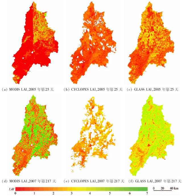
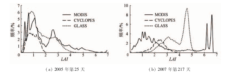
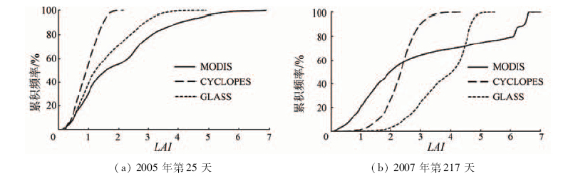
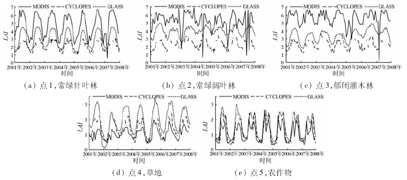
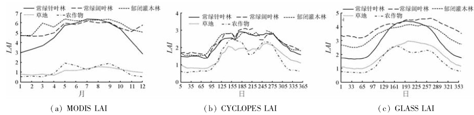
Leaf area index (LAI) is a primary parameter for characterizing vegetation canopy structure. Since LAI can affect many vegetation ecological processes, such as transpiration, interception and energy exchange, it is used as a critical input for ecological models and land surface process models. At present, several global LAI datasets have been generated from different satellite remote sensing data, such as AVHRR, MODIS and VEGETATION, by different retrieval methods. MODIS, CYCLOPES and GLASS LAI datasets are those with higher spatial and temporal resolution. The spatial and temporal consistency of MODIS, CYCLOPES and GLASS LAI datasets was analyzed over Hanjiang River basin, which is covered with several vegetation types. Comparative study revealed the following characteristics: ① CYCLOPES LAI was observed to contain a large number of missing pixels, while MODIS and GLASS LAI products were more spatially and temporally complete. MODIS LAI contained many invalid pixels, whose LAI became much smaller abruptly in comparison with the LAI values just before or after this time. ② The spatial distributions of MODIS, CYCLOPES and GLASS LAI were mainly consistent with the vegetation types of the basin. The spatial distributions of MODIS and GLASS LAI were more consistent than those of CYCLOPES LAI. MODIS LAI was larger than GLASS LAI in forest pixels, while it was contrary in other pixels. CYCLOPES LAI was much smaller than MODIS and GLASS LAI in forest pixels. ③ MODIS, CYCLOPES and GLASS LAI products generally depicted similar temporal trajectories. GLASS LAI had the smoothest and completest trajectories, while the trajectories of MODIS LAI contained a large number of erratic fluctuations. All of these three LAI products depicted similar seasonal changes for different vegetation types. Compared with CYCLOPES LAI, a good agreement was achieved between MODIS and GLASS LAI values.
刘远, 周买春. MODIS,CYCLOPES和GLASS 3种LAI产品在韩江流域的对比[J]. 国土资源遥感, 2018, 30(1): 14-21.
Yuan LIU, Maichun ZHOU. Comparison of MODIS, CYCLOPES and GLASS LAI over Hanjiang River basin. Remote Sensing for Land & Resources, 2018, 30(1): 14-21.
Liu Y B,Ju W M,Chen J M,et al.Spatial and temporal variations of forest LAI in China during 2000—2010[J].Chinese Science Bulletin,2012,57(22):2846-2856.
[2]
Watson D J.Comparative physiological studies on the growth of field crops:I.Variation in net assimilation rate and leaf area between species and varieties,and within and between years[J].Annals of Botany,1947,11(41):41-76.
[3]
Chen J M,Black T A.Defining leaf area index for non-flat leaves[J].Plant,Cell and Environment,1992,15(4):421-429.
[4]
Champeaux J L,Masson V,Chauvin F.ECOCLIMAP:A global database of land surface parameters at 1 km resolution[J].Meteorological Applications,2005,12(1):29-32.
[5]
Los S O,Collatz G J,Sellers P J,et al.A global 9-yr biophysical land surface dataset from NOAA AVHRR data[J].Journal of Hydrometeorology,2000,1(2):183-199.
[6]
Ganguly S,Schull M A,Samanta A,et al.Generating vegetation leaf area index earth system data record from multiple sensors.Part 1:Theory[J].Remote Sensing of Environment,2008,112(12):4333-4343.
[7]
Baret F,Hagolle O,Geiger B,et al.LAI,fAPAR and fCover CYCLOPES global products derived from VEGETATION:Part 1:Principles of the algorithm[J].Remote Sensing of Environment,2007,110(3):275-286.
[8]
Deng F,Chen J M,Plummer S,et al.Algorithm for global leaf area index retrieval using satellite imagery[J].IEEE Transactions on Geoscience and Remote Sensing,2006,44(8):2219-2229.
[9]
Myneni R B,Hoffman S,Knyazikhin Y,et al.Global products of vegetation leaf area and fraction absorbed PAR from year one of MODIS data[J].Remote Sensing of Environment,2002,83(1/2):214-231.
[10]
Bacour C,Baret F,Béal D,et al.Neural network estimation of LAI,fAPAR,fCover and LAI×Cab,from top of canopy MERIS reflectance data:Principles and validation[J].Remote Sensing of Environment,2006,105(4):313-325.
[11]
Hu J N,Tan B,Shabanov N,et al.Performance of the MISR LAI and FPAR algorithm:A case study in Africa[J].Remote Sensing of Environment,2003,88(1/2):324-340.
[12]
Hu J N,Su Y,Tan B,et al.Analysis of the MISR LAI/FPAR product for spatial and temporal coverage,accuracy and consistency[J].Remote Sensing of Environment,2007,107(1/2):334-347.
[13]
Baret F,Weiss M,Lacaze R,et al.GEOV1:LAI and FAPAR essential climate variables and FCOVER global time series capitalizing over existing products.Part1:Principles of development and production[J].Remote Sensing of Environment,2013,137:299-309.
[14]
Liu Y,Liu R G,Chen J M,et al.Expanding MISR LAI products to high temporal resolution with MODIS observations[J].IEEE Transactions on Geoscience and Remote Sensing,2012,50(10):3915-3927.
[15]
Xiao Z Q,Liang S L,Wang J D,et al.Use of general regression neural networks for generating the GLASS leaf area index product from time-series MODIS surface reflectance[J].IEEE Transactions on Geoscience and Remote Sensing,2014,52(1):209-223.
[16]
Pisek J,Chen J M,Deng F.Assessment of a global leaf area index product from SPOT-4 vegetation data over selected sites in Canada[J].Canadian Journal of Remote Sensing,2007,33(4):341-358.
[17]
Liu R,Chen J M,Liu J,et al.Application of a new leaf area index algorithm to China’s landmass using MODIS data for carbon cycle research[J].Journal of Environmental Management,2007,85(3):649-658.
[18]
Li X F,Ju W M,Zhou Y L,et al.Retrieving leaf area index of forests in red soil hilly region using remote sensing data[C]//Proceedings of the SPIE,Volume 7471,Second International Conference on Earth Observation for Global Changes.Chengdu,China:SPIE,2009:74710L.
[19]
Garrigues S,Lacaze R,Baret F,et al.Validation and intercomparison of global Leaf Area Index products derived from remote sensing data[J].Journal of Geophysical Research:Biogeosciences,2008,113(G2):G02028.
Xiang Y,Xiao Z Q,Liang S L,et al.Validation of Global LAnd Surface Satellite(GLASS) leaf area index product[J].Journal of Remote Sensing,2014,18(3):573-596.
[21]
Jacquemoud S,Baret F.PROSPECT:A model of leaf optical properties spectra[J].Remote Sensing of Environment,1990,34(2):75-91.
[22]
Verhoef W.Light scattering by leaf layers with application to canopy reflectance modeling:The SAIL model[J].Remote Sensing of Environment,1984,16(2):125-141.
[23]
Ran Y H,Li X,Lu L,et al.Large-scale land cover mapping with the integration of multi-source information based on the Dempster-Shafer theory[J].International Journal of Geographical Information Science,2012,26(1):169-191.
Ran Y H,Li X,Lu L.China land cover classification at 1 km spatial resolution based on a multi-source data fusion approach[J].Advances in Earth Science,2009,24(2):192-203.
Liu Y,Zhou M C.Comparative analysis on three land cover datasets based on IGBP classification system over Hanjiang River basin[J].Remote Sensing Technology and Application,2017,32(3):575-584.
 2018, Vol. 30
  ), 周买春(