1. State Key Laboratory of Remote Sensing Science, Beijing Normal University and Institute of Remote Sensing and Digital Earth of Chinese Academy of Sciences, Beijing 100875, China 2. State Key Laboratory of Earth Surface Processes and Resource Ecology, Beijing Normal University, Beijing 100875, China 3. Key Laboratory of Environmental Change and Natural Disaster of Ministry of Education, Beijing Normal University, Beijing 100875, China 4. Beijing Engineering Research Center for Global Land Remote Sensing Products, Beijing Normal University, Beijing 100875, China 5. College of Tourism and Environment, Shaanxi Normal University, Xi’an 710062, China;
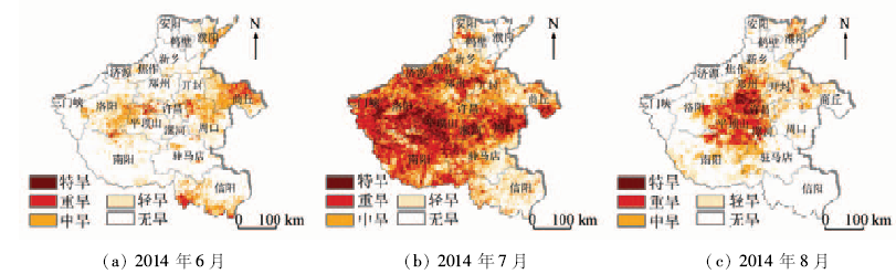
Henan Province was therefore chosen as the study area in this paper. The temperature condition index (TCI),vegetation condition index (VCI) and rainfall condition index (TRCI) were calculated by using the EOS-MODIS surface temperature product MOD11A2,vegetation index products MOD13A3 and tropical rainfall measuring mission’s monthly rainfall rate data TRMM3B43 from 2005 to 2014. Then an agricultural drought index (ADI) monitoring model was built up by weighing these three indices and the weights were determined by using analytic hierarchy process (AHP) analysis method. Grading indices of ADI were derived in terms of the classification scales of drought for standardized precipitation index (SPI) which were authorized by national standard. Finally,the ADI monitoring model was constructed to analyze the drought situation in Henan Province in 2014. The results indicate that the ADI proposed in this paper can well capture the temporal and spatial characteristics of the drought situation in Henan Province.
王俊霞, 朱秀芳, 刘宪锋, 潘耀忠. 基于多源遥感数据的旱情评价研究——以河南省为例[J]. 国土资源遥感, 2018, 30(1): 180-186.
Junxia WANG, Xiufang ZHU, Xianfeng LIU, Yaozhong PAN. Research on agriculture drought monitoring method of Henan Province with multi-sources data. Remote Sensing for Land & Resources, 2018, 30(1): 180-186.
Zhang Q,Yao Y B,Li Y H,et al.Research progress and prospect on the monitoring and early warning and mitigation technology of meteorological drought disaster in Northwest China[J].Advances in Earth Science,2015,30(2):196-213.
Qiu H J,Cao M M,Hao J Q,et al.Relationship between frequency and magnitude of drought damage in China in 1950—2010[J].Scientia Geographica Sinica,2013,33(5):576-580.
[4]
Rhee J,Im J,Carbone G J.Monitoring agricultural drought for arid and humid regions using multi-sensor remote sensing data[J].Remote Sensing of Environment,2010,114(12):2875-2887.
Zhang A Z,Jia G S.Monitoring meteorological drought in semiarid regions using multi-sensor microwave remote sensing data[J].Remote Sensing of Environment,2013,134:12-23.
[7]
Tadesse T,Wilhite D A,Harms S K,et al.Drought monitoring using data mining techniques:A case study for Nebraska,USA[J].Natural Hazards,2004,33(1):137-159.
[8]
李天祺. 基于MODIS陆地产品的河南省旱灾监测方法研究[D].北京:北京师范大学,2015.
Li T Q.Study on Agricultural Drought Monitoring in Henan Province Based on MODIS Products[D].Beijing:Beijing Normal University,2015.
[9]
杜灵通. 基于多源空间信息的干旱监测模型构建及其应用研究[D].南京:南京大学,2013.
Du L T.Drought Monitoring Model Based on Multi-Source Spatial Information and Its Application[D].Nanjing:Nanjing University,2013.
[10]
田庆久,闵祥军.植被指数研究进展[J].地球科学进展,1998,13(4):327-333.
Tian Q J,Min X J.Advances in study on vegetation indices[J].Advance in Earth Sciences,1998,13(4):327-333.
[11]
Kogan F N.Remote sensing of weather impacts on vegetation in non-homogeneous areas[J].International Journal of Remote Sensing,1990,11(8):1405-1419.
Li J L,Lu Y,Jin J,et al.Drought monitoring in Guangxi based on TVDI[J].Popular Science and Technology,2014,16(6):21-23.
[13]
Kogan F N.Application of vegetation index and brightness temperature for drought detection[J].Advances in Space Research,1995,15(11):91-100.
[14]
McKee T B,Doesken N J,Kleist J.The relationship of drought frequency and duration to time scales[C]//Proceedings of the 8th Conference of Applied Climatology.Anaheim,California:American Meteorological Society,1993.
[15]
马苏. 洞庭湖流域农业干旱遥感监测研究[D].长沙:湖南师范大学,2012.
Ma S.Research on the Remote Sensed Monitoring of Agricultral Drought in the Lake Dongting Basin[D].Changsha:Hunan Normal University,2012.
[16]
Theon J S.The tropical rainfall measuring mission(TRMM)[J].Advances in Space Research,1994,14(3):159-165.
Li H P,Zhang S Q,Gao Z Q,et al.Evaluating the utility of MODIS vegetation index for monitoring agricultural drought[J].Spectroscopy and Spectral Analysis,2013,33(3):756-761.
Sun L,Wang F,Li B G,et al.Study on drought monitoring of Wuling Mountain area based on multi-source data[J].Transactions of the Chinese Society for Agricultural Machinery,2014,45(1):246-252.
[20]
Lloyd-Hughes B,Saunders M A.A drought climatology for Europe[J].International Journal of Climatology,2002,22(13):1571-1592.
Ministry of Water Resources of the People’s Republic of China.SL 424—2008 Standard of Classification for Drought Severity[S].Beijing:China Water Power Press,2009.
 2018, Vol. 30
  ), 朱秀芳2,3,4(