High precision geometric rectification of HJ-1A/B CCD imagery based on satellite observation angle information
Liang YANG1(), Yi JIA2, Wanshou JIANG1(), Guo ZHANG1
1.State Key Laboratory of Information Engineering in Surveying, Mapping and Remote Sensing,Wuhan University,Wuhan 430079, China 2.Chang Guang Satellite Technology Co., Ltd., Changchun 130000, China
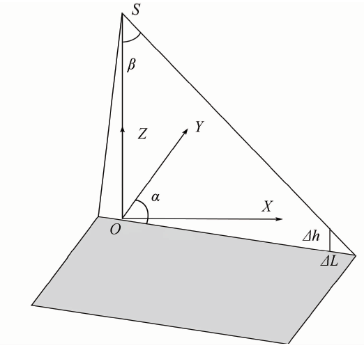
The available standard products of the domestic satellite HJ-1A/B CCD image are level II images, which are generated with systematic correction without considering the distortions caused by terrain undulation. Lacking of the geometric imaging model, it is difficult to do a reliable image rectification on the level II image with the existing methods in the range with big terrain undulation. To solve this problem, the authors propose a method to reconstruct the imaging geometric model based on the observation angle information, which is stored in a SatAngle.txt file. With the reconstructed RPC model, the HJ-1A/B CCD image can be orthorectified just like an original image with rigorous imaging geometric model. The experimental results show that the proposed method can effectively improve the rectification precision and the stability of geometric model fitting.
Tang P, Zhang H W, Zhao Y C , et al. Practice and thoughts of the automatic processing of multispectral images with 30 m spatial resolution on the global scale[J]. Journal of Remote Sensing, 2014,18(2):231-253.
Xiong W C, Shen W M, Wang Q , et al. Research on HJ-1A/B satellites data automatic geometric precision correction design[J]. Engineering Science, 2014,16(3):37-42.
Tang L, Tang P, Yan F L , et al. Design and implementation of automatic accurate geometric correction system for HJ-1 CCD images[J]. Journal of Computer Applications, 2012,32(s2):237-241.
Shan X J, Tang P, Hu C M , et al. Automatic geometric precise correction technology and system based on hierarchical image matching for HJ-1A/B CCD images[J]. Journal of Remote Sensing, 2014,18(2):254-266.
Hu J C, Zhou Z F . HJ-1CCD image geometric accurate rectification based on fast matching and linear rubber sheeting[J]. Hubei Agricultural Sciences, 2015,54(3):703-704,708.
Li Q W, Zhao W L, Yang X M , et al. AST algorithm-based geometric accurate rectification of large HJ satellite image[J]. Remote Sensing for Land and Resources, 2014,26(4):14-22.doi: 10.6046/gtzyyg.2014.04.03.
Pang J P, Hao J M, Zhao J P . Improved algorithm based on SURF for image registration[J]. Remote Sensing for Land and Resources, 2017,29(1):110-115.doi: 10.6046/gtzyyg.2017.01.17.
[8]
Savopol F, Armenakis C .Modelling of the IRS-1C satellite pan stereo-imagery using the DLT approach[C]//Proceedings of 1998 IAPRS Commission IV Symposium on GIS-Between Visions and Applications,Stuttgart:[s.n.], 1998: 511-514.
[9]
Hattori S, Ono T, Raser C F, et al. Orientation of high-resolution satellite images based on affine projection [C]//Proceedings of International Archives of Photogrammetry and Remote Sensing.Amsterdam: ISPRS, 2000: 359-366.
Zhang J Q, Zhang Z X . Strict geometric model based on affine transformation for remote sensing image with high resolution[J]. Geomatics and Information Science of Wuhan University, 2002,27(6):555-559.
[11]
Tao C V, Hu Y . A comprehensive study of the rational function model for photogrammetric processing[J]. Photogrammetric Engineering and Remote Sensing, 2001,67(12):1347-1357.
doi: 10.1002/jqs.617
Zhang G, Li Y, Zhu X Y , et al. Application of RFM in geometric rectification of optical satellite image[J]. Spacecraft Recovery and Remote Sensing, 2010,31(4):51-57.
Yang B L, Lyu T T, Wang S J , et al. Ortho-rectification method for Pleiades satellite images[J]. Remote Sensing for Land and Resources, 2015,27(3):25-29.doi: 10.6046/gtzyyg.2015.03.05.
 2018, Vol. 30
  ), 贾益2, 江万寿1(