Estimation of soil moisture with drought indices in Huaihe River Basin of East China
Wen ZHANG1(), Yan REN2(), Xiaolin MA3, Yijie HU4
1. School of Remote Sensing and Information Engineering, Wuhan University, Wuhan 430079, China 2. Patent Examination Cooperation Center of the Patent Office,SIPO,Zhengzhou 450046,China 3. Administration of Baisha Reservoir, Yuzhou 461670, China 4. School of Resource and Environment, North China University of Water Resources and Electric Power, Zhengzhou 450045, China
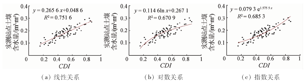
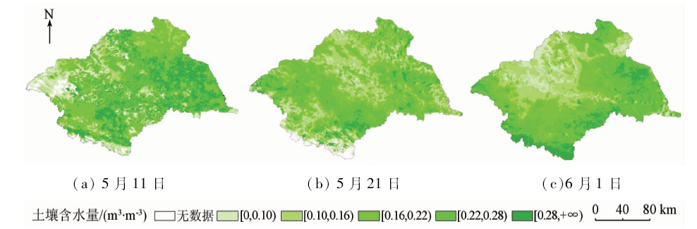
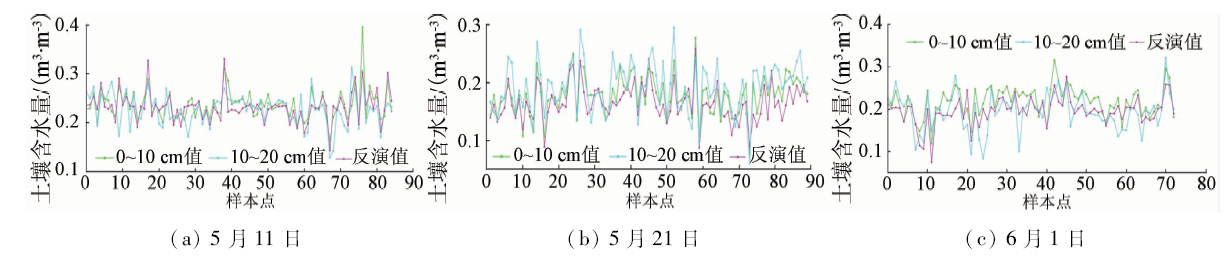
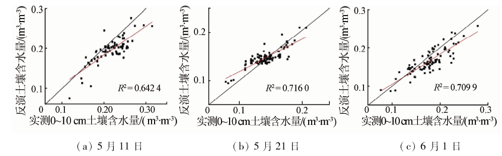
In this study, the authors examined the estimation of soil moisture with various drought indices in Huihe River Basin of East China. MODIS data were used for the estimation. Such drought indices as apparent thermal inertia (ATI) and vegetation supply water index (VSWI) were used for the estimation. On the basis of these drought indices, the authors integrated the drought indices into a comprehensive drought index (CDI) for the study to estimate soil moisture in East China. As dimensionless data, CDI cannot represent the actual soil moisture. The authors introduced the measured data, and built the correlation model between CDI and measured data. CDI can therefore be converted to soil moisture through the model. Finally, the authors used the measured data to verify the reliability and accuracy of the estimation results. The results show that the correlation between measured data and estimation data is high, and R2 values are around 0.7. The method in this study has great application value for estimating soil moisture in large area.
张文, 任燕, 马晓琳, 胡艺杰. 基于综合干旱指数的淮河流域土壤含水量反演[J]. 国土资源遥感, 2018, 30(2): 73-79.
Wen ZHANG, Yan REN, Xiaolin MA, Yijie HU. Estimation of soil moisture with drought indices in Huaihe River Basin of East China. Remote Sensing for Land & Resources, 2018, 30(2): 73-79.
Chen C F, Son N T, Chang L Y , et al. Monitoring of soil moisture variability in relation to rice cropping systems in the Vietnamese Mekong Delta using MODIS data[J]. Applied Geography, 2011,31(2):463-475.
doi: 10.1016/j.apgeog.2010.10.002
Liu M, Wang L L, Cai Q P . Compaveral typical soil’s water content measuring with FDR and TDR[J].Water Resources Informatization, 2016(6):32-36.
[3]
Wagner W, Hahn S, Kidd R , et al. The ASCAT soil moisture product:A review of its specifications,validation results,and emerging applications[J]. Meteorologische Zeitschrift, 2013,22(1):5-33.
doi: 10.1127/0941-2948/2013/0399
[4]
Jordan C F . Derivation of leaf-area index from quality of light on the forest floor[J]. Ecology, 1969,50(4):663-666.
doi: 10.2307/1936256
[5]
Kahle A B . A simple thermal model of the Earth’s surface for geologic mapping by remote sensing[J]. Journal of Geophysical Research, 1977,82(11):1673-1680.
doi: 10.1029/JB082i011p01673
[6]
Price J C . Thermal inertia mapping:A new view of the earth[J]. Journal of Geophysical Research, 1977,82(18):2582-2590.
doi: 10.1029/JC082i018p02582
[7]
Price J C . On the analysis of thermal infrared imagery:The limited utility of apparent thermal inertia[J]. Remote Sensing of Environment, 1985,18(1):59-73.
doi: 10.1016/0034-4257(85)90038-0
[8]
Jackson R D, Pinter Jr P J. Detection of water stress in wheat by measurement of reflected solar and emitted thermal IR radiation [C]//Spectral Signatures of Objects in Remote Sensing.Versailles:Institut National de la Recherche Agronomique, 1981: 399-406.
[9]
Carlson T N, Gillies R R, Perry E M . A method to make use of thermal infrared temperature and NDVI measurements to infer surface soil water content and fractional vegetation cover[J]. Remote Sensing Reviews, 1994,9(1/2):161-173.
doi: 10.1080/02757259409532220
[10]
Sandholt I, Rasmussen K, Andersen J . A simple interpretation of the surface temperature/vegetation index space for assessment of surface moisture status[J]. Remote Sensing of Environment, 2002,79(2/3):213-224.
doi: 10.1016/S0034-4257(01)00274-7
[11]
赵英时 . 遥感应用分析原理与方法[M]. 北京: 科学出版社, 2003.
Zhao Y S. Analysis Principle and Method of Remote Sensing Applications[M]. Beijing: Science Press, 2003.
Guo Y T, Xu J G . Coupling coordination measurement of urbanization and eco-environment system in Huaihe River Basin of China based on fuzzy matter element theory[J]. Chinese Journal of Applied Ecology, 2013,24(5):1244-1252.
Diao W, Meng L K, Zhang D Y , et al. Application of MODIS data on the drought monitoring of Hubei Province[J].Water Resources Informatization, 2013(1):12-15.
Shen G R, Tian G L . Remote sensing monitoring of drought in Huanghe, Huaihe and Haihe Plain based on GIS:The calculation of crop water stress index model[J]. Acta Ecologica Sinica, 2000,20(2):224-228.
Wang P X, Gong J Y, Li X W . Vegetation temperature condition index and its application for drought monitoring[J]. Geomatics and Information Science of Wuhan University, 2001,26(5):412-418.
[17]
Nichol J E, Abbas S . Integration of remote sensing datasets for local scale assessment and prediction of drought[J]. Science of the Total Environment, 2015,505:503-507.
doi: 10.1016/j.scitotenv.2014.09.099
pmid: 25461052
[18]
Cai G Y, Du M Y, Liu Y. Regional drought monitoring and analyzing using MODIS data:A case study in Yunnan Province [C]//Proceedings of the 4th IFIP TC 12 Conference on Computer and Computing Technologies in Agriculture IV.Nanchang,China:Springer, 2010: 243-251.
[19]
宋荣杰 . 基于遥感的旱区土壤湿度反演方法研究[D]. 杨凌:西北农林科技大学, 2013.
Song R J . Study on Soil Moisture Inversion Method Based on Remote Sensing[D]. Yangling:Northwest A and F University, 2013.
Wu L, Zhang Y Z, Xie W H , et al. The inversion of soil water content by the improved apparent thermal inertia[J]. Remote Sensing for Land and Resources, 2013,25(1):44-49.doi: 10.6046/gtzyyg.2013.01.08.
 2018, Vol. 30
  ), 任燕2(