1. Institute of Network Technology, Beijing University of Posts and Telecommunications, Beijing 100876, China 2. National Satellite Meteorological Center, China Meteorological Administration, Beijing 100081, China 3. Insitute of Desert Meteorology, China Meteorological Administration, Urumqi 830002, China 4. Xinjiang Academy of Surveying and Mapping, Urumqi 830002, China
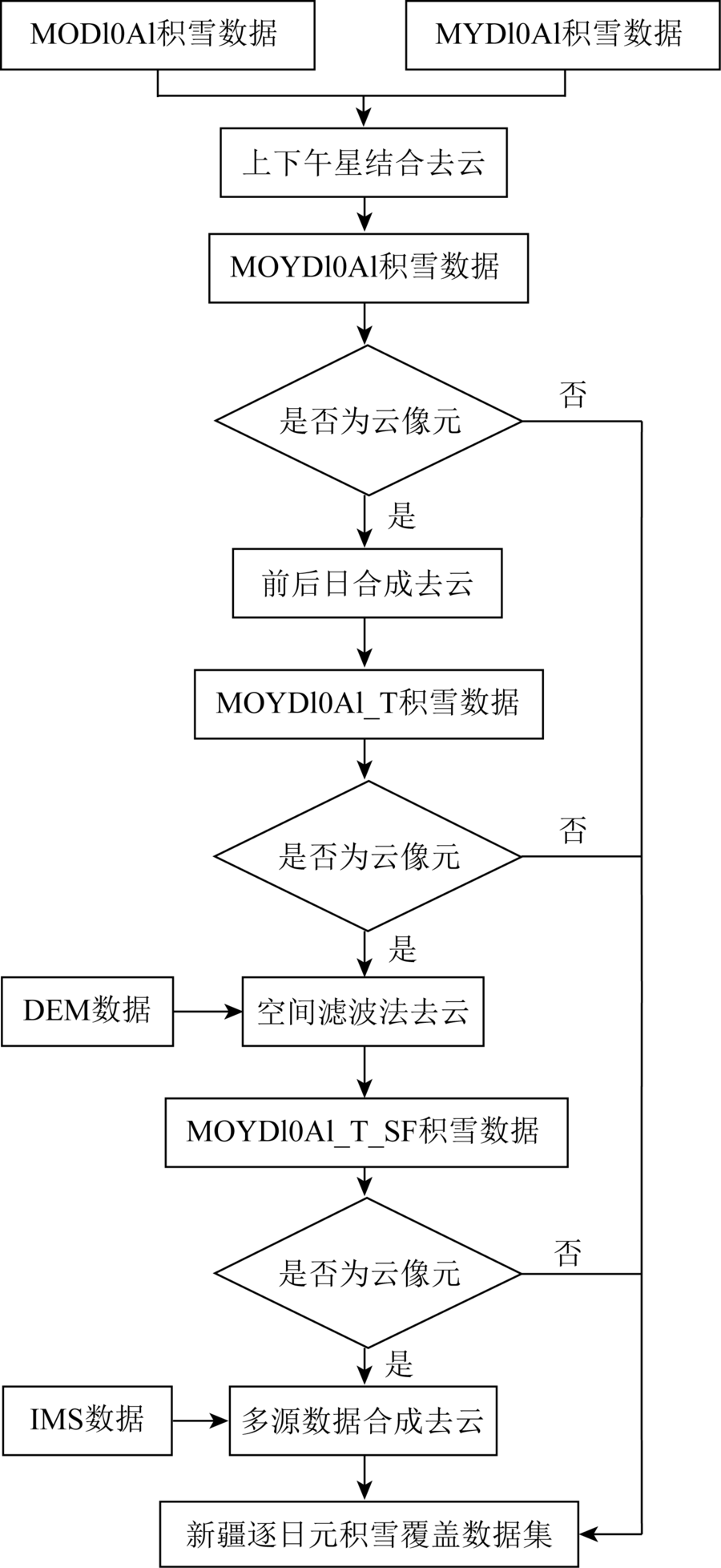
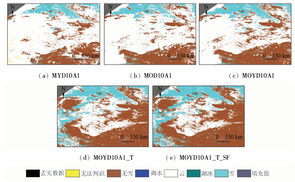
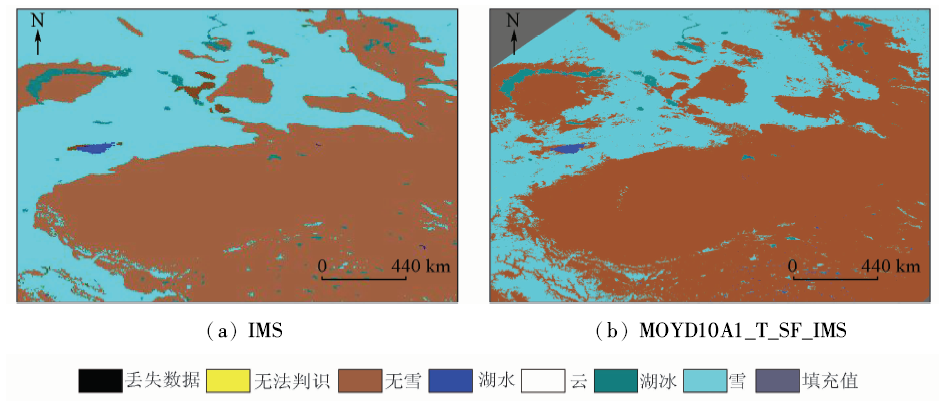
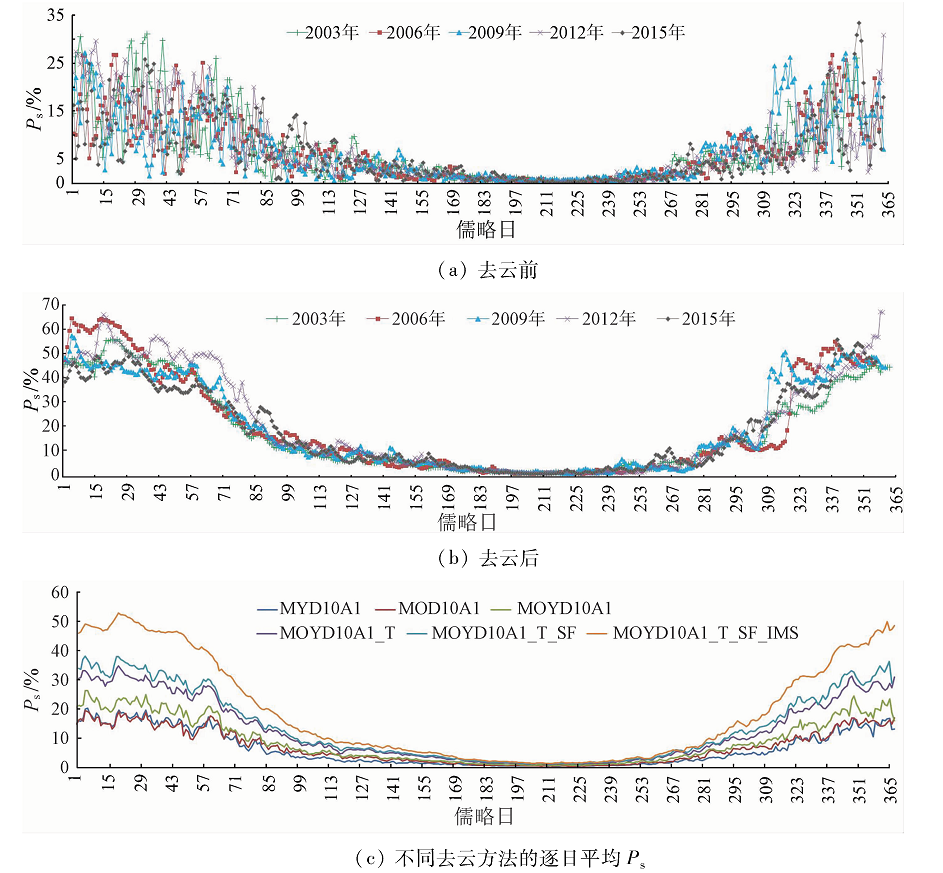
MODIS snow product data constitute one of the most common data in the real-time monitoring and the research on snow cover; nevertheless, the cloud is the biggest factor affecting the application of MODIS snow cover products (MOD10A1 and MYD10A1) to real-time monitoring and researching daily snow cover in Xinjiang region. By introducing such data as the interactive multi-sensor snow ice mapping system (IMS) data and the meteorological station observation data and combining the existent cloud removal methods based on temporal filter method, spatial filter method and multi-sensor data fusion method, the authors established a new cloud removal method based on multi-source remote sensing data, with which the 15-year-long daily snow cover product in clear air of the study area from 2002 to 2016 was generated. In addition, the accuracy of the cloud removed product was evaluated with field experiment data. The results show that the overall monitoring accuracy of the new product after cloud removal reaches 90.61% in the study area, which is close to the overall monitoring accuracy (93.3%) of the MODIS clear air snow cover product before cloud removal in the study area.
Liu Y, Wang H, Zhang P , et al. Accuracy evaluation of MODIS atmospheric correction and its effects on surface-snow density extraction[J]. Remote Sensing for Land and Resources, 2011,23(1):128-132.doi: 10.6046/gtzyyg.2011.01.26.
Ma L Y, Li J G, Li S . Snowmelt flood disaster monitoring based on FY-3/MERSI in Xinjiang[J]. Remote Sensing for Land and Resources, 2015,27(4):73-78.doi: 10.6046/gtzyyg.2015.04.12.
Hu L Q, Wu P F, Liang F C , et al. Analyzing the effect of snow cover in spring and winter and air temperature on frozen ground depth in Xinjiang[J] Journal of Glaciology and Geocryology, 2014,36(1):48-54.
Bai S Y, Wu Q, Shi J Q , et al. Relationship between the spatial and temporal distribution of snow depth and the terrain over the Tibetan Plateau[J]. Remote Sensing for Land and Resources, 2015,27(4):171-178.doi: 10.6046/gtzyyg.2015.04.26.
Liang S Z, Shi P, Xing Q G . A comparison between the algorithms for removing cloud pixel from MODIS NDVI time series data[J]. Remote Sensing for Land and Resources, 2011,23(1):33-36.doi: 10.6046/gtzyyg.2011.01.06.
Sun Z W, Yu P S, Xia L , et al. Progress in study of snow parameter inversion by passive microwave remote sensing[J]. Remote Sensing for Land and Resources, 2015,27(1):9-15.doi: 10.6046/gtzyyg.2015.01.02.
[8]
Xie H J, Wang X W, Liang T G . Development and assessment of combined Terra and Aqua snow cover products in Colorado Plateau,USA and northern Xinjiang,China[J]. Journal of Applied Remote Sensing, 2009,3(1):033559.
doi: 10.1117/1.3265996
Wang Z Y, Che T . Validation and assessment of cloud obscuration reduction of snow cover products in arid areas in China[J]. Arid Zone Research, 2012,29(2):312-319
Liu Y, Li Y, Zhang P . Extraction of snow cover information in sparse vegetation area based on spectral measurement and SRF by using MODIS data[J]. Remote Sensing for Land and Resources, 2013,25(1):26-32.doi: 10.6046/gtzyyg.2013.01.05.
Xu J H, Shu H, Li Y . Mapping of monthly mean snow depth in Northern Xinjiang using a multivariate nonlinear regression Kriging model based on MODIS snow cover data[J]. Remote Sensing for Land and Resources, 2015,27(3):84-91.doi: 10.6046/gtzyyg.2015.03.15.
Zhang R J, Zhao F Y, Fang H B , et al. Remote sensing survey of existing snowlines in the past 30 years in Qinghai-Tibet Plateau[J]. Remote Sensing for Land and Resources, 2010,22(s1):59-63.doi: 10.6046/gtzyyg.2010.s1.14.
Li G H, Wang C, Xi X H , et al. Extraction of glacier snowline based on airborne LiDAR and hyperspectral data fusion[J]. Remote Sensing for Land and Resources, 2013,25(3):79-84.doi: 10.6046/gtzyyg.2013.03.14.
Huang X D, Hao X H, Wang W , et al. Algorithms for cloud removal in MODIS daily snow products[J]. Journal of Glaciology and Geocryology, 2012,34(5):1118-1126.
Tang Z G, Wang J, Li H Y , et al. Accuracy validation and cloud obscuration removal of MODIS fractional snow cover products over Tibetan Plateau[J]. Remote Sensing Technology and Application, 2013,28(3):423-430.
Zhang H, Qiu Y B, Zheng Z J , et al. Comparative study of the feasibility of cloud removal methods based on MODIS seasonal snow cover data over the Tibetan Plateau[J]. Journal of Glaciology and Geocryology, 2016,38(3):714-724.
Zhao M Y, Bie Q, He L , et al. Estimating snow cover accuracy from MODIS and AMSR-E with cloud removal methodology in Qilian Mountains[J]. Arid Land Geography, 2014,37(2):325-332.
Zhang Y, Huang X D, Wang W , et al. Validation and algorithm redevelopment of MODIS daily fractional snow cover products[J]. Arid Zone Research, 2013,30(5):808-814.
Huang X D, Zhang X T, Li X , et al. Accuracy analysis for MODIS snow products of MOD10A1 and MOD10A2 in Northern Xinjiang Area[J]. Journal of Glaciology and Geocryology, 2007,29(5):722-729.
[20]
Dankers R, Jong S M D . Monitoring snow-cover dynamics in Northern Fennoscandia with SPOT VEGETATION images[J]. International Journal of Remote Sensing, 2004,25(15):2933-2949.
doi: 10.1080/01431160310001618374
[21]
Hartman R K, Rost A A, Anderson D M. Operational processing of multi-source snow data [C]//Proceedings of the 63rd Annual Western Snow Conference.Sparks,Nevada:Western Snow Conference, 1995: 147-151.
[22]
Hall D K, Riggs G A, Salomonson V V , et al. MODIS snow-cover products[J]. Remote Sensing of Environment, 2002,83(1/2):181-194.
doi: 10.1016/S0034-4257(02)00095-0
[23]
Parajka J, Pepe M, Rampini A , et al. A regional snow-line method for estimating snow cover from MODIS during cloud cover[J]. Journal of Hydrology, 2010,381(3/4):203-212.
doi: 10.1016/j.jhydrol.2009.11.042
[24]
Gao Y, Xie H J, Lu N , et al. Toward advanced daily cloud-free snow cover and snow water equivalent products from Terra-Aqua MODIS and Aqua AMSR-E measurements[J]. Journal of Hydrology, 2010,385(1/4):23-35.
doi: 10.1016/j.jhydrol.2010.01.022
Fu W X, Shen H F, Li X H , et al. Adaptively spatio-temporal weighted method for removing cloud obscuration from MODIS daily snow cover products[J]. Remote Sensing Information, 2016,31(2):36-43.
[26]
Hall D K, Riggs G A, Salomonson V V . Algorithm Theoretical Basis Document (ATBD) for the MODIS Snow and Sea Ice-Mapping Algorithms[R]. Washington:NASA, 2001.
Hou X G, Zhang P, Zheng Z J , et al. Study of snow depth retrieval based on multi-source data about Aletai Area[J]. Remote Sensing Technology and Application, 2015,30(1):178-185.
Liu X, Jin X, Ke C Q . Accuracy evaluation of the IMS snow and ice products in stable snow covers regions in China[J]. Journal of Glaciology and Geocryology, 2014,36(3):500-507.
 2018, Vol. 30
  ), 郑照军2(