1. College of Environment and Resources,Fuzhou University,Fuzhou 350116,China 2.Postdoctoral Research Station of Information and Communication Engineering, Fuzhou University, Fuzhou 350116, China 3. Key Lab of Spatial Data Mining and Information Sharing, Ministry of Education, Fuzhou 350116, China 4.Center for Region and Urban and Rural Planning,Fuzhou 350116,China 5.Zhicheng College,Fuzhou University,Fuzhou 350002,China
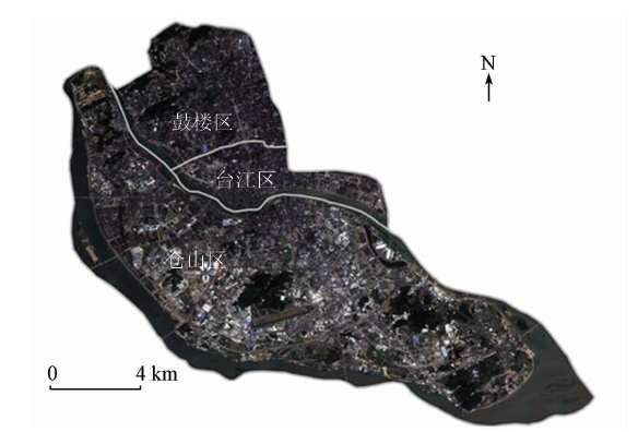
The urban roof greening has the effects such as water interception and ecological environment improvement, and can be an important part of sponge city construction. Taking Gulou, Taijiang, Cangshan Districts of Fuzhou City as the study objects and the remote sensing image of Landsat8 OLI as the main data, the authors extracted the roof greening rate based on sequential maximum angle convex cone(SMACC), constructed the relational models of roof greening rate and global vegetation moisture index(GVMI) humidity indicator, and then simulated and analyzed the roof greening rates. The results show that the roof greening rate in the three districts of Fuzhou is overall low, with an average of only 17.34%; the proportion of greening rate of 10%~20% is 66.55%, and only 5.11% is higher than 50%. The greening rates are different, and there are also changes in humidity, indicating that the roof vegetation has remarkable water interception capacity. The quadratic fumction model of roof humidity h and greening rate r is the optimization model. When the roof greening rate is higher than 16.30%, the intercepting effect begins to be obvious. In the process of greening rate increasing from 30% to 60%, the increasing speed of intercepting capacity becomes the fastest, with an average of up to 57.9%. Two typical blocks were selected and the roof greening rates were simulated and analyzed, which further proves the rationality of the above model. The result confirms the intercepting capacity of roof greening and determines the roof greening threshold under the target of water interception, which provides important reference for sponge city construction.
林璐, 许章华, 黄旭影, 吕福康, 王前锋, 林倩. 福州海绵城市建设中屋顶绿化的截水作用研究[J]. 国土资源遥感, 2018, 30(2): 223-230.
Lu LIN, Zhanghua XU, Xuying HUANG, Fukang LYU, Qianfeng WANG, Qian LIN. Study of water storage effect of roof greening in the construction of Fuzhou sponge city. Remote Sensing for Land & Resources, 2018, 30(2): 223-230.
Dietz M E . Low impact development practices:A review of current research and recommendations for future directions[J]. Water,Air,and Soil Pollution, 2007,186(1/4):351-363.
doi: 10.1007/s11270-007-9484-z
[2]
Church S P . Exploring Green Streets and rain gardens as instances of small scale nature and environmental learning tools[J]. Landscape and Urban Planning, 2015,134:229-240.
doi: 10.1016/j.landurbplan.2014.10.021
[3]
Akbari H, Rose L S, Taha H . Analyzing the land cover of an urban environment using high-resolution orthophotos[J]. Landscape and Urban Planning, 2013,63(1):1-14.
doi: 10.1016/S0169-2046(02)00165-2
Liu C M, Zhang Y Y, Wang Z G , et al. The LID pattern for maintaining virtuous water cyclein urbanized area:A preliminary study of planning and techniques for sponge city[J]. Journal of Natural Resources, 2016,31(5):719-731.
Ming D P, Luo J C, Shen Z F , et al. Research on information extraction and target recognition from high resolution remote sensing image[J]. Science of Surveying and Mapping, 2005,30(3):18-20.
[8]
Huston R, Chan Y C, Chapman H , et al. Source apportionment of heavy metals and ionic contaminants in rainwater tanks in a subtropical urban area in Australia[J]. Water Research, 2012,46(4):1121-1132.
doi: 10.1016/j.watres.2011.12.008
pmid: 22196953
Qiu B X . Key techniques in classification and reconstruction of ecological cities[J].Urban Planning Forum, 2010(3):1-13.
[10]
Oberndorfer E, Lundholm J, Bass B , et al. Green roofs as urban ecosystems:Ecological structures,functions,and services[J]. BioScience, 2007,57(10):823-833.
doi: 10.1641/B571005
Shao T R, Li C S, Zeng H . Resource potential assessment of urban roof greening and development strategies:A case study in Futian central district,Shenzhen,China[J]. Acta Ecologica Sinica, 2012,32(3):4852-4860.
[12]
Niu H, Clark C, Zhou J T , et al. Scaling of economic benefits from green roof implementation in Washington, DC[J]. Environmental Science and Technology, 2010,44(11):4302-4308.
doi: 10.1021/es902456x
pmid: 20462260
[13]
Morales-Pinzón T, Rieradevall J, Gasol C M , et al. Modelling for economic cost and environmental analysis of rainwater harvesting systems[J]. Journal of Cleaner Production, 2015,87:613-626.
doi: 10.1016/j.jclepro.2014.10.021
[14]
García-Montoya M, Bocanegra-Martínez A, Nápoles-Rivera F , et al. Simultaneous design of water reusing and rainwater harvesting systems in a residential complex[J]. Computers and Chemical Engineering, 2015,76:104-116.
doi: 10.1016/j.compchemeng.2015.02.011
[15]
Ward S, Memon F A, Butler D . Performance of a large building rainwater harvesting system[J]. Water Research, 2012,46(16):5127-5134.
doi: 10.1016/j.watres.2012.06.043
pmid: 22840659
[16]
Getter K L, Rowe D B, Andresen J A . Quantifying the effect of slope on extensive green roof stormwater retention[J]. Ecological Engineering, 2007,31(4):225-231.
doi: 10.1016/j.ecoleng.2007.06.004
Li P H, Zhang X Y . Research on remote sensing application in the investigation of green roof[J]. Journal of Jiangxi University of Science and Technology, 2011,32(5):16-18.
Shen X L, Shao Z F, Tian Y J . Build-up areas extraction by textural feature and visual attention mechanism[J]. Acta Geodaetica et Cartographica Sinica, 2014,43(8):842-847.
Qiang Y G, Yin J P, Zhu E , et al. Extraction of building area from remote sensing images based on wavelets transformation and mathematical morphology[J]. Journal of Image and Graphics, 2008,13(8):1459-1464.
Qiao W F, Liu Y S, Xiang L Z , et al. Research on extracting building height rapidly based on high-resolution remote sensing images without parameters[J]. Journal of Geo-Information Science, 2015,17(8):995-1000.
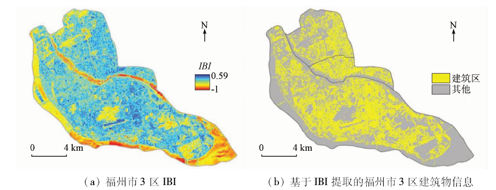
Xu H Q . A new index-based built-up index(IBI) and its eco-environmental significance[J]. Remote Sensing Technology and Application, 2007,22(3):301-308.
Cui Y J, Zhu L, Zhao L J . Abstraction and analysis of vegetation information based on object-oriented and spectra features[J]. Acta Ecologica Sinica, 2013,33(3):867-875.
Cui T X, Gong Z N, Zhao W J , et al. Research on estimating wetland vegetation abundance based on spectral mixture analysis with different endmember model:A case study in Wild Duck Lake wetland,Beijing[J]. Acta Ecologica Sinica, 2013,33(4):1160-1171.
[26]
Roberts D A, Gardner M, Church R , et al. Mapping chaparral in the Santa Monica Mountains using multiple endmember spectral mixture models[J]. Remote Sensing of Environment, 1998,65(3):267-279.
doi: 10.1016/S0034-4257(98)00037-6
[27]
Ichoku C, Karnieli A . A review of mixture modeling techniques for sub-pixel land cover estimation[J]. Remote Sensing Reviews, 1996,13(3/4):161-186.
doi: 10.1080/02757259609532303
Yang S X, Zhang X, Shuai T , et al. Estimating Karst rocky desertification feature abundance by pixel unmixing[J]. Remote Sensing Technology and Application, 2014,29(5):823-832.
Zhang X H, Tian Q J . Application of the temperature-moisture index to the improvement of remote sensing identification accuracy of mangrove[J]. Remote Sensing for Land and Resources, 2012,24(3):65-70.doi: 10.6046/gtzyyg.2012.03.13.
Zhou B R, Li F X, Shen S H , et al. Principal component analysis method acquiring soil moisture information from MODIS data[J]. Journal of Applied Meteorological Science, 2009,20(1):114-118.
Gu S Y, Li W B, Zhang W J . Retrieving soil moisture from TRMM/TMI[J]. Journal of Remote Sensing, 2005,9(2):166-175.
[33]
Ceccato P, Flasse S, Grégoire J M . Designing a spectral index to estimate vegetation water content from remote sensing data:Part 2.Validation and applications[J]. Remote Sensing of Environment, 2002,82(2/3):198-207.
doi: 10.1016/S0034-4257(02)00036-6
 2018, Vol. 30
  ), 许章华1,2,3,4(