Please wait a minute...
 
国土资源遥感  2018, Vol. 30 Issue (3): 1-8    DOI: 10.6046/gtzyyg.2018.03.01
     本期目录 | 过刊浏览 | 高级检索 |
遥感视频卫星应用展望
袁益琴1,2, 何国金1,3(), 江威1,2, 王桂周1,3
1. 中国科学院遥感与数字地球研究所,北京 100094
2. 中国科学院大学, 北京 100049
3. 海南省地球观测重点实验室,三亚 572000
Application of earth observation system of video satellite
Yiqin YUAN1,2, Guojin HE1,3(), Wei JIANG1,2, Guizhou WANG1,3
1. Institute of Remote Sensing and Digital Earth Chinese Academy of Sciences, Beijing 100094, China
2. University of Chinese Academy of Sciences, Beijing 100049, China
3. Key Laboratory for Earth Observation of Hainan Province, Sanya 572000, China
全文: PDF(3845 KB)   HTML  
输出: BibTeX | EndNote (RIS)      
摘要 

目前遥感技术发展迅速,人类逐步进入了以高时间分辨率、高光谱分辨率和高空间分辨率为特征的对地观测新时代。视频卫星的出现为遥感实时对地观测提供了新的契机,契合未来遥感即时商业发展的需求。首先总结视频卫星的国内外发展现状和趋势,介绍视频卫星的成像原理,对比视频卫星的滚扫式成像模式与传统卫星的推扫式成像模式的差异,展望了视频卫星未来在大型商业区车辆实时监测、自然灾害应急快速响应、重大工程监控和军事安全等4个重点领域的应用潜力。

服务
把本文推荐给朋友
加入引用管理器
E-mail Alert
RSS
作者相关文章
袁益琴
何国金
江威
王桂周
关键词 对地观测视频卫星时间分辨率空间分辨率卫星组网    
Abstract

Remote sensing technology is developing rapidly at present,and human beings are entering a new era of earth observation characterized by high temporal resolution,high spectral resolution and high spatial resolution step by step. The appearance of video satellite brings a new favorable opportunity for real-time observation of remote sensing,which corresponds to the needs of future remote sensing real-time commercial development. This paper summarizes the development status and trend of video satellite both in China and abroad. Then the paper introduces the image-forming principle and characteristics of video satellite,and makes a comparison between the roll-broom imaging mode of video satellite and the push-broom imaging mode of traditional satellite. This paper proposes the application of future video satellite from four important aspects, i.e., business intelligence real-time monitoring,the whole process of natural disasters and dynamic monitoring,environment dynamic monitoring and military security.

Key wordsearth observation    video satellite    temporal resolution    spatial resolution    satellite network
收稿日期: 2017-03-01      出版日期: 2018-09-10
:  TP79  
基金资助:国家重点研发计划全球变化及应对专项项目“大尺度全球变化数据产品快速生成方法”(2016YFA0600302);海南省重大科技计划项目“海南省遥感大数据服务平台建设与应用示范”(ZDKJ2016021);“海洋信息资源利用关键技术研究与智慧南海综合服务应用示范”(ZDKJ2016015-1)
通讯作者: 何国金
作者简介: 袁益琴(1992-),女,硕士研究生,主要从事遥感图像处理与应用研究。Email: yuanyq@radi.ac.cn。
引用本文:   
袁益琴, 何国金, 江威, 王桂周. 遥感视频卫星应用展望[J]. 国土资源遥感, 2018, 30(3): 1-8.
Yiqin YUAN, Guojin HE, Wei JIANG, Guizhou WANG. Application of earth observation system of video satellite. Remote Sensing for Land & Resources, 2018, 30(3): 1-8.
链接本文:  
https://www.gtzyyg.com/CN/10.6046/gtzyyg.2018.03.01      或      https://www.gtzyyg.com/CN/Y2018/V30/I3/1
卫星/平台 发射时间 国家或机构 视频颜色 视频分辨率/m 帧率/(帧/s) 成像区域/km2 视频长度/s
LAPAN-TUB SAT 2007.1 印度尼西亚 黑白 200 50 81×81 -
Sumbandliasat 2009.9 南非 黑白 - - - -
太阳动态观测卫星 (SDO) 2010.2 美国NASA 彩色 - - - 1 800
SkySat-1 2013.11 美国Skybox 黑白 1.1 30 2×1.1 90
UrtheCast 2014.1 加拿大 彩色 1.0 30 5×3.4 90
Surrey -V1C 2014.2 美国SSTUS 彩色 <1 100 1 800~3 600
SkySat-2 2014.7 美国Skybox 黑白 1.1 30 2×1.1 90
LAPAN-A2 2014.9 印度尼西亚国家
航空航天研究所
黑白 200 50 81×81 -
天拓二号 2014.9 中国国防科大 黑白 5 25 - 180
吉林一号 2015.10 中国长光卫星公司 彩色 1.13 25 4.6×3.4 90
Tab.1  视频卫星的主要技术指标[11]
项目名称 主要指标
轨道 太阳同步轨道,轨道高度为578 km(Skysat-1)和629 km(Skysat-2)
整星质量/kg 约83
尺寸 小于60 cm×60 cm×95 cm
数据
传输
天线口径/m φ2.4
星下点空间
分辨率/m
0.9(PAN),2(RGB+NIR)
幅宽/km 8
文件格式 16 bit(有效量化位数16bit)
视频
模式
谱段/nm 450~900(PAN)
空间分辨
率/m
1.1
视频覆盖
范围
2.0 km×1.1 km
持续时间/s 90
帧频/(帧/s) 30
帧尺寸 2 560×1 080像素
视频大小 1 920 ×1 080像素
文件格式 MPEG-4压缩(H.264)
视频属性 黑白,1080P全高清视频
Tab.2  Skysat卫星的主要技术指标[14]
项目名称 主要指标
国际空间站轨道 360 km
视频模式 空间分辨率/m 1.0
视频覆盖范围 5.0 km×3.4 km
持续时间/s 90
帧频/(帧/s) 3
帧尺寸 3 024×4 536像素
帧速率 3.25 fps
文件格式 MPEG-4压缩(H.264)
视频属性 彩色,1 080P全高清视频
Tab.3  UrtheCast卫星的“Iris”相机主要技术指标
项目名称 主要指标
轨道 近地太阳同步轨道,轨道高度为656 km
整星质量/kg 95
尺寸 小于60 cm×60 cm×95 cm
卫星转体/(度/秒) 3
侧摆角 -50°~50°
数据传输 天线口径/m φ2
视频模式 空间分辨率/m 1.13
视频覆盖范围 4.6 km×3.4 km
持续时间/s 90
帧频/(帧/s) 25
帧尺寸 2 160×3 840像素
视频大小 1 920×1 080像素
文件格式 MPEG-4压缩(H.264)
视频属性 贝尔彩色,4K超清视频
Tab.4  “吉林一号”视频星的主要技术指标
Fig.1  推扫成像模式示意图
Fig.2  目标凝视成像示意图[6]
Fig.3  从SkySat-1视频影像中进行车辆提取[19]
Fig.4  第一帧Skysat-1视频影像提取车辆密度[19]
Fig.5  2013年9月威利斯顿的红外影像[23]
Fig.6  定南县稀土矿开采图
Fig.7  也门被导弹炸毁的地面
Fig.8  SkySat-1对迪拜飞机实时监测
[1] Gómez C, White J C, Wulder M A . Optical remotely sensed time series data for land cover classification:A review[J]. ISPRS Journal of Photogrammetry and Remote Sensing, 2016,116:55-72.
doi: 10.1016/j.isprsjprs.2016.03.008
[2] 李德仁, 王密, 沈欣 , 等. 从对地观测卫星到对地观测脑[J]. 武汉大学学报(信息科学版), 2017,42(2):143-149.
doi: 10.13203/j.whugis20160526
Li D R, Wang M, Shen X , et al. From earth observation satellite to earth observation brain[J]. Geomatics and Information Science of Wuhan University, 2017,42(2):143-149.
[3] 刘韬 . 国外视频卫星发展研究[J].国际太空, 2014(9):50-56.
Liu T . Research of national and International video satellites[J]. International, 2014(9):50-56.
[4] 朱厉洪, 回征, 任德锋 , 等. 视频成像卫星发展现状与启示[J].卫星应用,2015(10):23-28.
Zhu L H, Hui Z, Ren D F , et al. Video imaging satellite development and the enlightenment[J].Satellite Application, 2015(10):23-28.
[5] 潘益云, 李海超 . 低轨视频卫星成像特性分析[J]. 航天器工程, 2015,24(5):52-57.
Pan Y Y, Li H C . Imaging characteristics analysis for LEO video satellite[J]. Spacecraft Engineering, 2015,24(5):52-57.
[6] 付凯林, 杨芳, 黄敏 , 等. 低轨道视频卫星任务模式的研究与应用[ C]//北京力学会第21届学术年会暨北京振动工程学会第22届学术年会论文集.北京:北京力学会, 2015.
Fu K L, Yang F, Huang M , et al. Research in task mode of low earth orbit video satellite[ C]//Proceedings of the 21st Academic Society of Beijing and the 22nd Symposium of Beijing Institute of Vibration Engineering. 2015.
[7] 赵施柳 .热核艺术的震撼:NASA发布30分钟太阳4K影像[EB/OL].( 2015- 11- 02). .
Zhao S L .The shock of thermonuclear art: 4K video of sun about 30 minutes released by NANA[EB/OL].( 2015- 11- 02). .
[8] 王景泉 . 商业遥感卫星市场的现状与发展趋势[J].卫星应用, 2012(1):49-53.
Wang J Q . The status and development trend of commercial remote sensing satellite market[J].Satellite Application, 2012(1):49-53.
[9] 王握文, 刘小兵 .我首颗视频成像体制微卫星"天拓二号"发射成功[N/OL].光明日报, 2014- 09- 09(01). .
Wang W W,Liu X B .Tiantuo-2.China’s first video imaging system of micro satellite[N/OL].Guangming Daily, 2014- 09- 09(01). .
[10] 邹维荣,宗兆盾 .中国成功发射一颗米级高清动态视频卫星[EB/OL].( 2015- 10- 10). .
Zou W R,Zong Z D .A nanometers HD dynamic video satellite as successfully launched in China[EB/OL].( 2015- 10- 10). .
[11] 王余涛 . 空间视频成像市场前景尚不确定[J].卫星应用, 2014(7):64.
Wang Y T . Uncertain market prospect of video satellite[J].Satellite Application, 2014(7):64.
[12] 刘韬 . Skybox公司高分辨率小微卫星星座开启商业遥感2.0时代[J].卫星应用, 2014(3):70-71.
Liu T . High resolution small satellite companies such as Skybox open a 2.0 era of business remote sensing[J].Satellite Application, 2014(3):70-71.
[13] 张召才 . 国外芯片卫星发展研究[J].国际太空, 2014(5):45-49.
Zhang Z C . Research on the development of foreign chip satellites[J].Space International, 2014(5):45-49.
[14] 赵梦姣 .揭秘“吉林一号”组星-我国航天遥感应用商业化产业化迈出重要一步[EB/OL].( 2015- 10- 20). .
Zhao M J .Revelation of "Jilin-1" group star-a significant step of space remote sensing application commercialization industrialization in China[EB/OL].( 2015- 10- 20). .
[15] 赵英时 . 遥感应用分析原理与方法[M]. 北京: 科学出版社, 2003: 87-91.
Zhao Y S. Analysis Principle and Method of Remote Sensing Application[M]. Beijing: Science Press, 2003: 87-91.
[16] 航天东方红卫星有限公司 .一种新型敏捷卫星机动中成像方法:中国, 201410163903.1[P]. 2014 -04-22.
China Spacesat Company.Novel imaging method in agile satellite maneuvering:CN, 201410163903.1[P]. 2014 -04-22.
[17] 孙志远, 张刘, 金光 , 等. 视频小卫星凝视姿态跟踪的仿真与实验[J]. 光学精密工程, 2011,19(11):2715-2723.
doi: 10.3788/OPE.20111911.2715
Sun Z Y, Zhang L, Jin G , et al. Simulation and experiment on attitude tracking control of small TV satellite[J]. Optics and Precision Engineering, 2011,19(11):2715-2723.
[18] 徐雨果, 刘团结, 尤红建 , 等. HJ1B星CCD相机内方位元素的在轨标定方法[J]. 遥感技术与应用, 2011,26(3):309-314.
Xu Y G, Liu T J, You H J , et al. On-orbit calibration of interior orientation for HJ1BCCD camera[J]. Remote Sensing Technology and Application, 2011,26(3):309-314.
[19] 
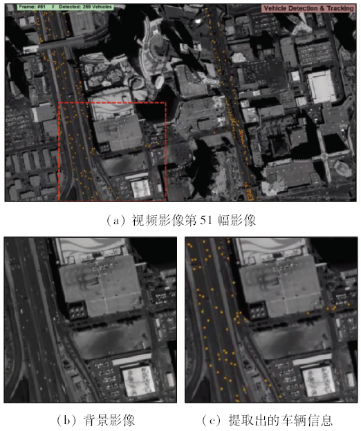
Kopsiaftis G, Karantzalos K. Vehicle detection and traffic density monitoring from very high resolution satellite video data [C]//Proceedings of 2015 IEEE International Geoscience and Remote Sensing Symposium (IGARSS).Milan,Italy:IEEE, 2015: 1881-1884,doi: 10.1109/IGARSS.2015.7326160.
[20] Yang T, Wang X W, Yao B W , et al. Small moving vehicle detection in a satellite video of an urban area[J]. Sensors, 2016,16(9):1528.
doi: 10.3390/s16091528 pmid: 5038801
[21] Larsen S Ø, Koren H, Solberg R . Traffic monitoring using very high resolution satellite imagery[J]. Photogrammetric Engineering & Remote Sensing, 2009,75(7):859-869.
doi: 10.14358/PERS.75.7.859
[22] Leitloff J, Hinz S, Stilla U . Vehicle detection in very high resolution satellite images of city areas[J]. IEEE Transactions on Geoscience and Remote Sensing, 2010,48(7):2795-2806.
doi: 10.1109/TGRS.2010.2043109
[23] Manthos D .SkyTruth releases dynamic map of global flaring[EB/OL].( 2014- 08- 22). .
[24] 张国清, 武向荣 . 高分辨率商业遥感卫星的发展及军事应用[J].现代军事, 2012(6):38-41.
Zhang G Q, Wu X R . The development of high resolution remote sensing satellite business and military applications[J].Conmilit, 2012(6):38-41.
[25] 段云龙, 赵海庆 . 高分辨率遥感卫星的发展及其军事应用探索[J].电光系统, 2013(3):12-16.
Duan Y L, Zhao H Q . Discussion of the development of high-resolution remote sensing satellites and the military applications[J].Electronic and Electro-Optical Systems, 2013(3):12-16.
[26] 李德仁 .推广遥感应用,仍需行业人士共同努力[EB/OL].( 2016- 08- 10). .
Li D R .Promotion of remote sensing application needs the industry to work together[EB/OL].( 2016- 08- 10). .
[1] 张春森, 吴蓉蓉, 李国君, 崔卫红, 冯晨轶. 面向对象的高空间分辨率遥感影像箱线图变化检测方法[J]. 国土资源遥感, 2020, 32(2): 19-25.
[2] 汪洁, 殷亚秋, 于航, 蒋存浩, 万语. 基于RS和GIS的浙江省矿山地质环境遥感监测[J]. 国土资源遥感, 2020, 32(1): 232-236.
[3] 刘玉锋, 潘英, 李虎. 基于高空间分辨率遥感数据的天山云杉树冠信息提取研究[J]. 国土资源遥感, 2019, 31(4): 112-119.
[4] 姚丙秀, 黄亮, 许艳松. 一种结合超像素和图论的高空间分辨率遥感影像分割方法[J]. 国土资源遥感, 2019, 31(3): 72-79.
[5] 卫宝泉, 索安宁, 李颖, 赵建华. LBV变换在国产ZY-3卫星影像中应用研究探讨[J]. 国土资源遥感, 2019, 31(3): 87-94.
[6] 黄惠, 郑雄伟, 孙根云, 郝艳玲, 张爱竹, 容俊, 马红章. 基于引力自组织神经网络的震害遥感影像分类[J]. 国土资源遥感, 2019, 31(3): 95-103.
[7] 樊宪磊, 阎宏波, 瞿瑛. 基于HJ-1A/B CCD地表反照率估算方法比较与验证[J]. 国土资源遥感, 2019, 31(3): 123-131.
[8] 郑艺, 林懿琼, 周建, 甘伟修, 林广旋, 许方宏, 林光辉. 基于资源三号的雷州半岛红树林种间分类研究[J]. 国土资源遥感, 2019, 31(3): 201-208.
[9] 周阳, 张云生, 陈斯飏, 邹峥嵘, 朱耀晨, 赵芮雪. 基于DCNN特征的建筑物震害损毁区域检测[J]. 国土资源遥感, 2019, 31(2): 44-50.
[10] 吴佳奇, 汪韬阳, 彭雨芬, 张过. 视频卫星影像的Bayer插值重建[J]. 国土资源遥感, 2019, 31(2): 51-58.
[11] 梁林林, 江利明, 周志伟, 陈玉兴, 孙亚飞. 无人机遥感影像面向对象分类的冻土热融滑塌边界提取[J]. 国土资源遥感, 2019, 31(2): 180-186.
[12] 吕野, 胡翔云. 利用增量式马尔科夫随机场分割提取高空间分辨率遥感影像道路[J]. 国土资源遥感, 2018, 30(3): 76-82.
[13] 杨亮, 贾益, 江万寿, 张过. 基于观测角信息的HJ-1A/B卫星光学影像几何精纠正[J]. 国土资源遥感, 2018, 30(2): 60-66.
[14] 尹峰, 曹丽琴, 梁鹏. 改进的Welsh颜色迁移算法在GF-2图像融合中的应用[J]. 国土资源遥感, 2017, 29(4): 126-131.
[15] 孙娜, 高志强, 王晓晶, 罗志东. 基于高分遥感影像的黄土高原地区水体高精度提取[J]. 国土资源遥感, 2017, 29(4): 173-178.
Viewed
Full text


Abstract

Cited

  Shared   
  Discussed   
京ICP备05055290号-2
版权所有 © 2015 《自然资源遥感》编辑部
地址:北京学院路31号中国国土资源航空物探遥感中心 邮编:100083
电话:010-62060291/62060292 E-mail:zrzyyg@163.com
本系统由北京玛格泰克科技发展有限公司设计开发