An improved ICM algorithm for remote sensing image segmentation
Jun YANG1, Jianjie PEI2
1. School of Electronic and Information Engineering, Lanzhou Jiaotong University, Lanzhou 730070, China 2. Faculty of Geomatics, Lanzhou Jiaotong University & Gansu Provincial Engineering Laboratory for National Geographic State Monitoring, Lanzhou 730070, China;
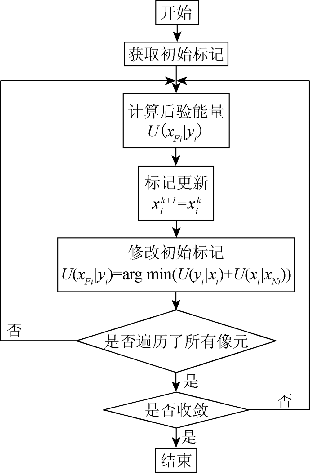
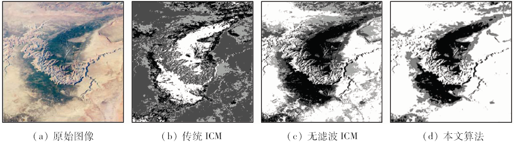
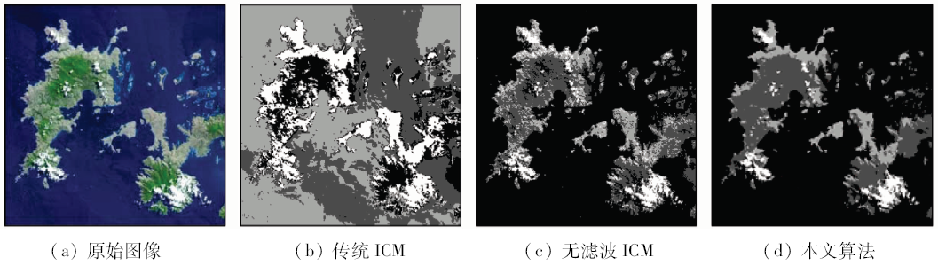
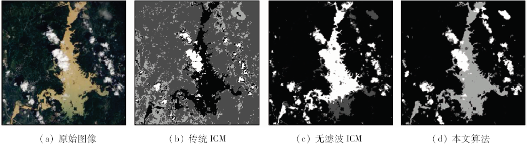
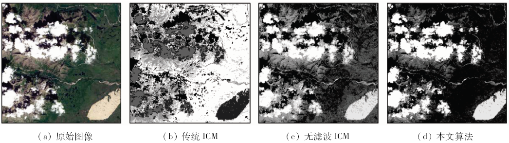
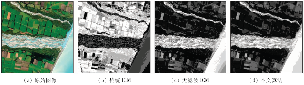
The traditional iterated conditional model(ICM)algorithm, when applied to remote sensing image segmentation, is easy to show discrete patches and isolated points. In view of this phenomenon, an improved ICM remote sensing segmentation algorithm is proposed which is based on Markov random field(MRF). First, the robust bilateral filter(BF)which is efficient in preserving edges and denoising was merged and used for the preprocessing of the remote sensing image, and then the Otsu algorithm was applied to obtaining the initial clusters. The algorithm could overcome some problems that occurred in the traditional K-means algorithm such as the inability in determining the number of clusters, difficulty in controlling algorithm complexities, and appearance of overlapping in the segmented regions. Next, the MRF was used to describe the pixel spatial correlation forming ICM remote sensing image segmentation algorithm with contextual information. By using remote sensing image data validation, the approach proposed in this paper realizes more reliable segmentation results in comparison with the traditional ICM algorithm.
Zheng C, Zhang Y, Wang L G . Multilayer semantic segmentation of remote-sensing imagery using a hybrid object-based Markov random field model[J]. International Journal of Remote Sensing, 2016,37(23):5505-5532.
doi: 10.1080/01431161.2016.1244364
[2]
Gaetano R, Masi G, Poggi G , et al. Marker-controlled watershed-based segmentation of multiresolution remote sensing images[J]. IEEE Transactions on Geoscience and Remote Sensing, 2015,53(6):2987-3004.
doi: 10.1109/TGRS.2014.2367129
Liang R F, Yang F B, Wang Y M , et al. A near-rectangle guided segmentation method for remote sensing images of corn field areas[J]. Remote Sensing for Land and Resources, 2016,28(3):53-59.doi: 10.6046/gtzyyg.2016.03.09.
Lu H, Fu X, Liu C , et al. Study of method for fast segmentation based on UAV image[J]. Remote Sensing for Land and Resources, 2016,28(2):72-78.doi: 10.6046/gtzyyg.2016.02.12.
[5]
Kato Z, Zerubia J . Markov Random Fields in Image Segmentation[M]. Hanover:Now Publisher, 2012.
[6]
Liu G Y, Wang L G, Hong L . Supervised image segmentation using region-level TS-MRF models[J]. Journal of Computational Information Systems, 2013,9(23):9533-9540.
doi: 10.12733/jcis7826
[7]
Doulgeris A P . An automatic u-distribution and Markov random field segmentation algorithm for PolSAR images[J]. IEEE Transactions on Geoscience and Remote Sensing, 2015,53(4):1819-1827.
doi: 10.1109/TGRS.2014.2349575
[8]
Rother C, Kolmogorov V, Blake A . "Grabcut":Interactive foreground extraction using iterated graph cuts[J]. ACM Transactions on Graphics(TOG), 2004,23(3):309-314.
doi: 10.1145/1015706
[9]
Tso B C K, Mather P M . Classification of multisource remote sensing imagery using a genetic algorithm and Markov random fields[J]. IEEE Transactions on Geoscience and Remote Sensing, 1999,37(3):1255-1260.
doi: 10.1109/36.763284
[10]
Chou P B, Brown C M . The theory and practice of Bayesian image labeling[J]. International Journal of Computer Vision, 1990,4(3):185-210.
doi: 10.1007/BF00054995
Hou Y M, Guo L . A novel SAR image segmentation method based on Markov random field[J]. Journal of Electronics & Information Technology, 2007,29(5):1069-1072.
Yang H L, Peng J H . Remote sensing classification based on Markov random field and fuzzy c-means clustering[J]. Acta Geodaeticaet Cartographica Sinica, 2012,41(2):213-218.
Xie Z, Xie N Q, Yao T T . An ICM clustering method based on image space[J]. Journal of Circuits and Systems, 2013,18(2):277-283,290.
[14]
Baumgartner J, Gimenez J, Scavuzzo M , et al. A new approach to segmentation of multispectral remote sensing images based on MRF[J]. IEEE Geoscience and Remote Sensing Letters, 2015,12(8):1720-1724.
doi: 10.1109/LGRS.2015.2421736
Liu G Y, Ma G R, Wang L G , et al. Image Modeling and Segmentation of Wavelet Domain Based on Markov Random Field[M]. Beijing: Science Press, 2010.
[16]
Geman S, Geman D .Stochastic relaxation, Gibbs distributions, and the Bayesian restoration of images[J].IEEE Transactions on Pattern Analysis and Machine Intelligence, 1984, PAMI-6(6):721-741.
doi: 10.1080/02664769300000058
pmid: 22499653
[17]
Sarkar A, Biswas M K, Kartikeyan B , et al. A MRF model-based segmentation approach to classification for multispectral imagery[J]. IEEE Transactions on Geoscience and Remote Sensing, 2002,40(5):1102-1113.
doi: 10.1109/TGRS.2002.1010897
[18]
Li S Z . Markov Random Field Modeling in Image Analysis[M]. 3rd ed.London:Springer, 2009.
[19]
Berthod M, Kato Z, Yu S , et al. Bayesian image classification using Markov random fields[J]. Image and Vision Computing, 1996,14(4):285-295.
doi: 10.1007/978-94-017-2217-9_45
 2018, Vol. 30