Comparison and analysis of the interference identification methods for microwave measurements over snow land
Ying WU, Sulin JIANG, Zhenhui WANG
Key Laboratory of Meteorological Disaster, Ministry of Education (KLME)/ Joint International Research Laboratory of Climate and Environment Change (ILCEC)/ Collaborative Innovation Center on Forecast and Evaluation of Meteorological Disasters (CIC-FEMD)/Key Laboratory for Aerosol-Cloud-Precipitation of China Meteorological Administration, Nanjing University of Information Science and Technology, Nanjing 210044, China
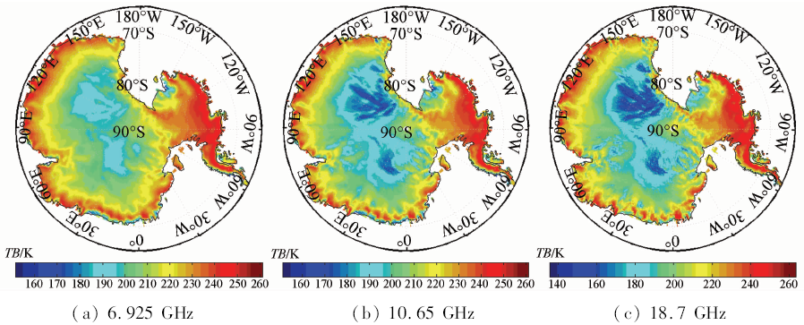
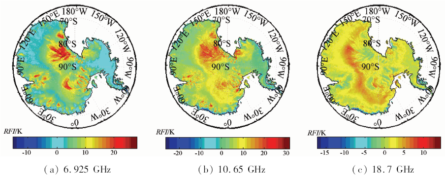
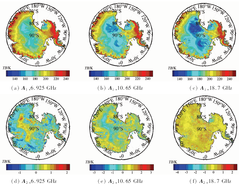
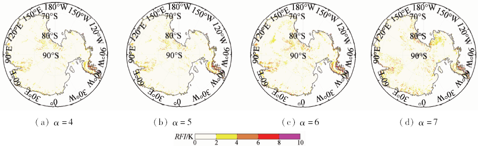
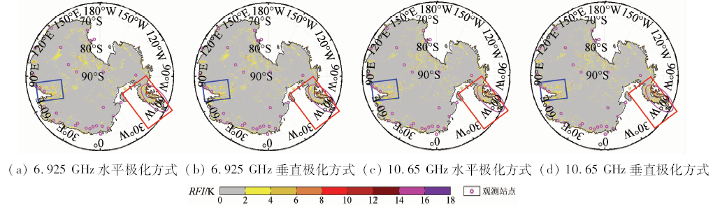
The influence of radio-frequency interference (RFI) on spaceborne microwave radiometer measurements is increasingly prominent, which largely reduces the accuracy of geophysical parameter inversion from microwave observations. RFI over Antarctica land was detected and analyzed using spectral difference, normalized principal component analysis (NPCA) and double principal component analysis (DPCA) method based on AMSR-E (the advanced microwave scanning radiometer - earth observing system) Leval 2A measurements during July 1-7, 2011. It is found that, over snow or ice-covered land, the RFI signals are difficult to be detected by spectral difference method, while NPCA method works but for costal areas. However, the DPCA method works well over the Atlantic land. Furthermore. It is also found that stronger RFI signals are detected widely over the Antarctica land at low frequency channels of AMSR-E, and most of the strong RFI signals are collocated with research stations. In general, the RFI is stronger at horizontal polarization channels than those at vertical polarization channels, but in some parts, RFI signals at 10.65 GHz for vertical polarization are stronger than those for horizontal polarization.
Zou X L . Serial of applications of satellite observations introduction to microwave imager radiance observations from polar-orbiting meteorological satellites[J]. Advances in Meteorological Science and Technology, 2012,2(3):45-50.
Shi J C, Du Y, Du J Y , et al. Progresses on microwave remote sensing of land surface parameters[J]. Science China Earth Sciences, 2012,55(7):1052-1078.
Zhang S B, Guan L . Effect of AMSR-E data interference on the retrieval of land surface parameters[J]. China Environmental Science, 2015,35(1):260-268.
Wu Y, Wang Z H . Advances in the study of land surface emissivity retrieval from passive microwave remote sensing[J]. Remote Sensing for Land and Resources, 2012,24(4):1-7.doi: 10.6046/gtzyyg.2012.04.01.
Qian B, Lu Q F, Yang S Y , et al. Review on microwave land surface emissivity by satellite remote sensing[J]. Progress in Geophysics, 2016,31(3):960-964.
Li Q, Zhong R F . Multiple surface parameters retrieval of simulated AMSR-E data[J]. Remote Sensing for Land and Resources, 2011,23(1):42-47.doi: 10.6046/gtzyyg.2011.01.08.
Bao Y S, Mao F, Min J Z , et al. Retrieval of bare soil moisture from FY-3B/MWRI data[J]. Remote Sensing for Land and Resources, 2014,26(4):131-137.doi: 10.6046/gtzyyg.2014.04.21.
Mao K B, Shi J C, Li Z L , et al. The land surface temperature and emissivity retrieved from the AMSR passive microwave data[J]. Remote Sensing for Land and Resources, 2005,17(3):14-17.doi: 10.6046/gtzyyg.2005.03.04.
Zhou F C, Song X N, Li Z L . Progress of land surface temperature retrieval based on passive microwave remote sensing[J]. Remote Sensing for Land and Resources, 2014,26(1):1-7.doi: 10.6046/gtzyyg.2014.01.01.
Liu J, Ma H Z, Yang L , et al. A survey of surface temperature retrieval by passive microwave remote sensing[J]. Remote Sensing Technology and Application, 2012,27(6):812-821.
Sun Z W, Yu P S, Xia L , et al. Progress in study of snow parameter inversion by passive microwave remote sensing[J]. Remote Sensing for Land and Resources, 2015,27(1):9-15.doi: 10.6046/gtzyyg.2015.01.02.
[12]
Li L, Njoku E G, Im E , et al. A preliminary survey of radio-frequency interference over the U.S. in Aqua AMSR-E data[J]. IEEE Transactions on Geoscience and Remote Sensing, 2004,42(2):380-390.
doi: 10.1109/TGRS.2003.817195
[13]
Li L, Gaiser P W, Bettenhausen M H , et al. WindSat radio-frequency interference signature and its identification over land and ocean[J]. IEEE Transactions on Geoscience and Remote Sensing, 2006,44(3):530-539.
doi: 10.1109/TGRS.2005.862503
[14]
Njoku E G, Ashcroft P, Chan T K , et al. Global survey and statistics of radio-frequency interference in AMSR-E land observations[J]. IEEE Transactions on Geoscience and Remote Sensing, 2005,43(5):938-947.
doi: 10.1109/TGRS.2004.837507
[15]
Wu Y, Weng F Z . Detection and correction of AMSR-E radio-frequency interference[J]. Acta Meteorologica Sinica, 2011,25(5):669-681.
doi: 10.1007/s13351-011-0510-0
[16]
Wu Y, Weng F Z . Applications of an AMSR-E RFI detection and correction algorithm in 1-DVAR over land[J]. Journal of Meteorological Research, 2014,28(4):645-655.
doi: 10.1007/s13351-014-3075-x
[17]
Lacava T, Coviello I, Faruolo M , et al. A multitemporal investigation of AMSR-E C-band radio-frequency interference[J]. IEEE Transactions on Geoscience and Remote Sensing, 2013,51(4):2007-2015.
doi: 10.1109/TGRS.2012.2228487
[18]
Zou X L, Zhao J, Weng F Z , et al. Detection of radio-frequency interference signal over land from FY-3B microwave radiation imager (MWRI)[J]. IEEE Transactions on Geoscience and Remote Sensing, 2012,50(12):4994-5003.
doi: 10.1109/TGRS.2012.2191792
[19]
Zhao J, Zou X L, Weng F Z . WindSat radio-frequency interference signature and its identification over Greenland and Antarctic[J]. IEEE Transactions on Geoscience and Remote Sensing, 2013,51(9):4830-4839.
doi: 10.1109/TGRS.2005.862503
Guan L, Zhang S B . Source analysis of radio-frequency interference over Europe land from advanced microwave scanning radiometer-E[J]. Acta Optica Sinica, 2014,34(7):0728004.
[21]
Research stations and transportation in Antarctica[EB/OL].[ 2016- 10- 18] .
 2018, Vol. 30