1. College of Earth Sciences, Chengdu University of Technology, Chengdu 610059, China 2. College of Engineering and Technical, Chengdu University of Technology, Leshan 614000, China 3. Key Laboratory of Geoscience Spatial Information Technology, Ministry of Nature Resources, Chengdu 610059, China
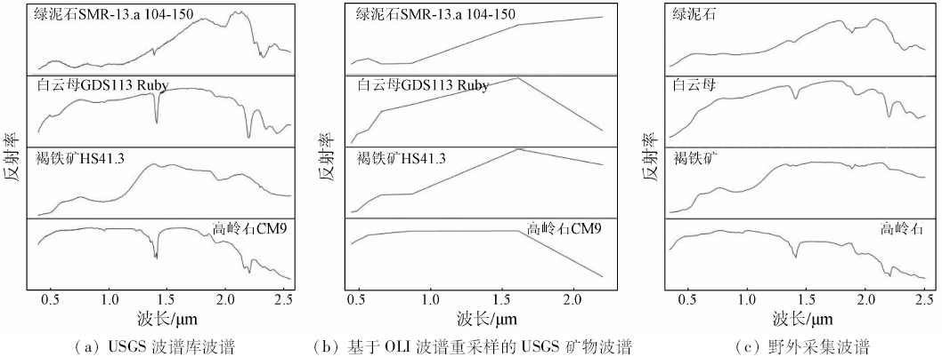
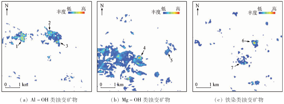
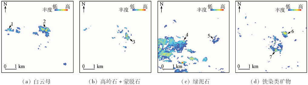
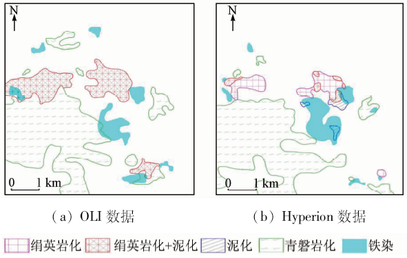
The enhancing of NIR band and SWIR2 band of OLI data makes the spectra become the diagnostic spectra of ferric iron minerals, Al-OH and Mg-OH alteration minerals. The authors used the mixture tuned matched filtering (MTMF) mapping method to extract ferric iron, Al-OH and Mg-OH alteration minerals in Tiegelong prospective block of the Duolong porphyry Cu-Au ore concentration area. Compared with the results of mineral mapping from Hyperion data, the three mineral mapping types extracted from Landsat8 OLI are reliable. At the same time, the spatial distribution pattern of alteration minerals agrees with the hydrothermal alteration zone of typical porphyry copper deposits. The remote sensing alteration zones from interior to exterior of the Tiegelong porphyry Cu ore block are phyllic+argillic zone (Al-OH minerals) and propylitic zone (Mg-OH minerals), and the ferric iron minerals are between the arephyllic+argillic and propylitic zones.
Rui Z Y, Lu Y, Li G M , et al. Looking forward to the prospects of porphyry copper deposits in Tibet[J]. Geology in China, 2003,30(3):302-308.
[3]
周平 . 新常态下中国铜资源供需前景分析与预测[D].北京:中国地质大学(北京), 2015.
Zhou P . An analysis and forecast of China copper supply and demand prospects under the new normal economy[D].Beijing:China University of Geosciences( Beijing), 2015.
[4]
Lowell J D, Guilbert J M . Lateral and vertical alteration-mineralization zoning in porphyry ore deposits[J]. Economic Geology, 1970,65(4):373-408.
doi: 10.2113/gsecongeo.65.4.373
[5]
Rowan L C, Schmidt R G, Mars J C . Distribution of hydrothermally altered rocks in the Reko Diq,Pakistan mineralized area based on spectral analysis of ASTER data[J]. Remote Sensing of Environment, 2006,104(1):74-87.
doi: 10.1016/j.rse.2006.05.014
[6]
Zhang T B, Yi G H, Li H M , et al. Integrating data of ASTER and landsat-8 OLI(AO) for hydrothermal alteration mineral mapping in Duolong porphyry Cu-Au deposit,Tibetan Plateau,China[J]. Remote Sensing, 2016,8(11):890.
doi: 10.3390/rs8110890
Zhang Y F, Yuan J M, Yang Z A , et al. Type classification of 2D scatter plot of remote sensing image based on the physical meaning and extraction of remote sensing alteration information[J]. Remote Sensing for Land and Resources, 2013,25(2):57-62.doi: 10.6046/gtzyyg.2013.02.11.
Zhang Y F, Wu D W, Yuan J M , et al. The model and application of multi-level detaching technique of remote sensing alteration information[J]. Remote Sensing for Land and Resources, 2011,23(4):6-13.doi: 10.6046/gtzyyg.2011.04.02.
[9]
Yang Z A, Peng S L, Zhu G C , et al. Spectrum spatial structure characteristic analysis of remote sensing alteration information and interference factors[J]. Journal of Central South University of Technology, 2009,16(4):647-652.
doi: 10.1007/s11771-009-0107-2
[10]
Sojdehee M, Rasa I, Nezafati N , et al. Application of spectral analysis to discriminate hydrothermal alteration zones at Daralu copper deposit,SE Iran[J]. Arabian Journal of Geosciences, 2015,9(1):41.
Zhang T B, Tang J X, Li Z J , et al. Remote sensing geological characteristics and ore prediction in the Ga’erqiong Cu-Au deposit,Tibet[J]. Remote Sensing for Land and Resources, 2014,26(4):170-178.doi: 10.6046/gtzyyg.2014.04.27.
[12]
Ramadan T M, Kontny A . Mineralogical and structural characterization of alteration zones detected by orbital remote sensing at Shalatein District,SE Desert,Egypt[J]. Journal of African Earth Sciences, 2004,40(1/2):89-99.
doi: 10.1016/j.jafrearsci.2004.06.003
[13]
Pournamdari M, Hashim M, Pour A B . Spectral transformation of ASTER and Landsat TM bands for lithological mapping of Soghan ophiolite complex,south Iran[J]. Advances in Space Research, 2014,54(4):694-709.
doi: 10.1016/j.asr.2014.04.022
Bie X J, Zhang T B, Sun C M , et al. Study of methods for extraction of remote sensing information of rocks and altered minerals from Luobusha ophiolite in East Tibet[J]. Remote Sensing for Land and Resources, 2013,25(3):72-78.doi: 10.6046/gtzyyg.2013.03.13.
[15]
Cui J, Yan B K, Wang R S , et al. Regional-scale mineral mapping using ASTER VNIR/SWIR data and validation of reflectance and mineral map products using airborne hyperspectral CASI/SASI data[J]. International Journal of Applied Earth Observation and Geoinformation, 2014,33:127-141.
doi: 10.1016/j.jag.2014.04.014
[16]
Di Tommaso I, Rubinstein N . Hydrothermal alteration mapping using ASTER data in the Infiernillo porphyry deposit, Argentina[J]. Ore Geology Reviews, 2007,32(1/2):275-290.
doi: 10.1016/j.oregeorev.2006.05.004
[17]
Rowan L C, Mars J C . Lithologic mapping in the Mountain Pass,California area using Advanced Spaceborne Thermal Emission and Reflection Radiometer(ASTER) data[J]. Remote Sensing of Environment, 2003,84(3):350-366.
doi: 10.1016/S0034-4257(02)00127-X
[18]
Abbaszadeh M, Hezarkhani A . Enhancement of hydrothermal alteration zones using the spectral feature fitting method in Rabor Area,Kerman,Iran[J]. Arabian Journal of Geosciences, 2013,6(6):1957-1964.
doi: 10.1007/s12517-011-0495-0
Yan B K, Liu S W, Wang R S , et al. Quantitative inversion of the SiO2 content in surface rocks using thermal infrared remote sensing[J]. Geological Bulletin of China, 2006,25(5):639-643.
Zhang Y J, Zeng Z M, Chen W . The methods for extraction of alteration anomalies from the ETM+(TM) data and their application:Method selection and technological flow chart[J]. Remote Sensing for Land and Resources, 2003,15(2):44-49.doi: 10.6046/gtzyyg.2003.02.11.
[21]
张廷斌 . 斑岩铜矿遥感蚀变信息重现性与优选研究[D]. 成都:西南交通大学, 2013.
Zhang T B . On the repeatability and optimization of remote sensing mineralized alterations about the porphyry copper deposits:A case study of the typical porphyry copper deposits in Tibet[D]. Chengdu:Southwest Jiaotong University, 2013.
[22]
Pour A B, Hashim M . Hydrothermal alteration mapping from Landsat-8 data,Sar Cheshmeh copper mining district,south-eastern Islamic Republic of Iran[J]. Journal of Taibah University for Science, 2015,9(2):155-166.
doi: 10.1016/j.jtusci.2014.11.008
Tang N, Wang C, Tang J X , et al. Alteration information extraction based on principal component analysis using OLI data:A case study of Doloong Cu-Au deposit,Tibet[J] Mineral Deposits, 2014,33(s1):745-746.
Cheng Y, Tong L Q . The research on model of the alteration mineral mapping base on multi-level separate background and an application examples[J]. Remote Sensing Technology and Application, 2015,30(3):586-591.
Liu J S, Hu B, He Z W . The application of remote sensing technique for porphyry copper exploration in the Gezan arc region[J]. Computing Techniques for Geophysical and Geochemical Exploration, 2015,37(6):790-796.
Hou Z Q, Lyu Q T, Wang A J , et al. Continental collision and related metallogeny:A case study of mineralization in Tibetan Orogen[J]. Mineral Deposits, 2003,22(4):319-333.
Zhang J S . Study on three porphyry-type deposits’geological features and regional structural ore-controlling model in Eastern Gandise Metallogenic Belt[D]. Chengdu:Chengdu University of Technology, 2012.
Hu Z H . Multivariate information prospecting prediction of Duo-Long porphyry copper deposit forecasting area in Tibet[D]. Chengdu:Chengdu University of Technology, 2012.
Sun Z M . Copper-gold mineralization and metallogenic regularity of Duolong mineralization area in western Bangongco-Nujiang[D]. Changchun:Jilin University, 2015.
[30]
Mars J C, Rowan L C . Regional mapping of phyllic-and argillic-altered rocks in the Zagros magmatic arc,Iran,using advanced spaceborne thermal emission and reflection radiometer(ASTER) data and logical operator algorithms[J]. Geosphere, 2006,2(3):161-186.
doi: 10.1130/GES00044.1
[31]
Bedini E . Mapping alteration minerals at Malmbjerg molybdenum deposit,central East Greenland,by Kohonen self-organizing maps and matched filter analysis of HyMap data[J]. International Journal of Remote Sensing, 2012,33(4):939-961.
doi: 10.1080/01431161.2010.542202
[32]
Clark R N, Swayze G A, Wise R A , et al. USGS Digital Spectral Library Splib06a[R].[s.l.]:U.S. Geological Survey, 2007.
[33]
Cudahy T J, Ramanaidou E R . Measurement of the hematite:Goethite ratio using field visible and near-infrared reflectance spectrometry in channel iron deposits,Western Australia[J]. Australian Journal of Earth Sciences, 1997,44(4):411-420.
doi: 10.1080/08120099708728322
[34]
Molan Y E, Refahib D, Tarashti A H . Mineral mapping in the Maherabad area,eastern Iran,using the HyMap remote sensing data[J]. International Journal of Applied Earth Observation and Geoinformation, 2014,27:117-127.
doi: 10.1016/j.jag.2013.09.014
[35]
张玉君 . Landsat8简介[J]. 国土资源遥感, 2013,25(1):176-177.
Zhang Y J . Introduction of Landsat8[J] Remote Sensing for Land and Resources[J], 2013,25(1):176-177.
[36]
Kruse F A, Baugh W M, Perry S L . Validation of DigitalGlobe WorldView-3 Earth imaging satellite shortwave infrared bands for mineral mapping[J]. Journal of Applied Remote Sensing, 2015,9(1):096044.
doi: 10.1117/1.JRS.9.096044
[37]
Asadzadeh S, De Souza Filho C R .A review on spectral processing methods for geological remote sensing[J]. International Journal of Applied Earth Observation and Geoinformation, 2016,47:69-90.
doi: 10.1016/j.jag.2015.12.004
[38]
Boardman J W, Kruse F A . Analysis of imaging spectrometer data using N-dimensional geometry and a mixture-tuned matched filtering approach[J]. IEEE Transactions on Geoscience and Remote Sensing, 2011,49(11):4138-4152.
doi: 10.1109/TGRS.2011.2161585
Yan B K, Dong X F, Wang Z , et al. Mineral information extraction technology by airborne hyperspectral remote sensing and its application progress:An example of mineralization belts of western China[J]. 2016,3(4):55-62.
 2018, Vol. 30
  ), 易桂花1, 钟康惠1, 别小娟1, 王继斌1, 孙姣姣1