Change detection for mine environment based on domestic high resolution satellite images
Lijuan WANG1,2,3, Xiao JIN2,3(), Hujun JIA2,3, Yao TANG2,3, Guochao MA2,3
1. College of Environment and Civil Engineering, Chengdu University of Technology, Chengdu 610045, China 2. Sichuan Academy of Safety Science and Technology, Chengdu 610045, China 3. Key Laboratory of Measurement and Control of Major Hazard Sources in Sichuan Province, Chengdu 610045, China
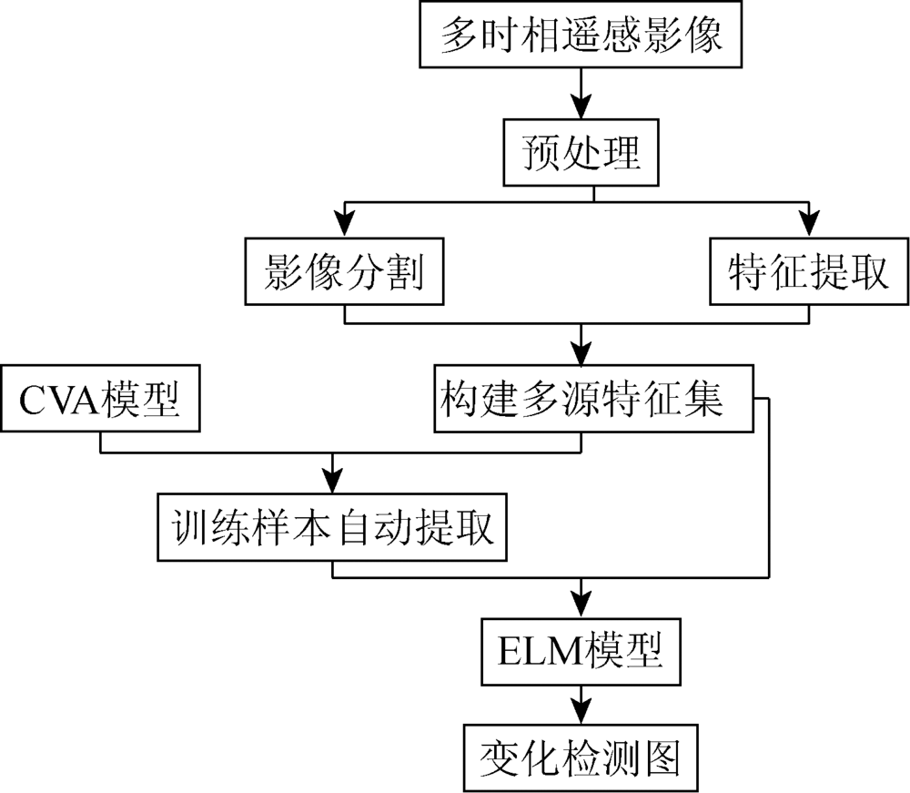
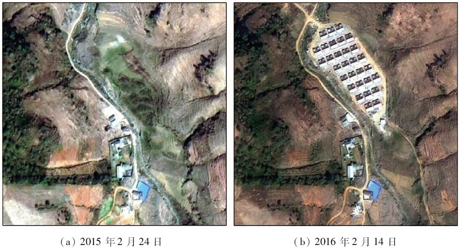
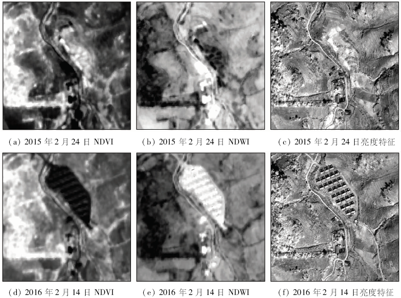
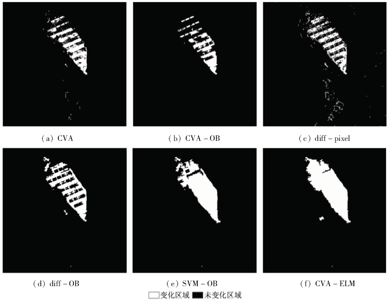
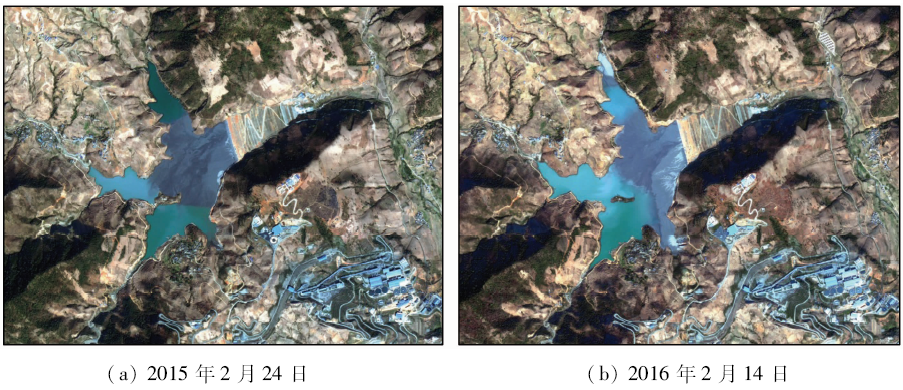
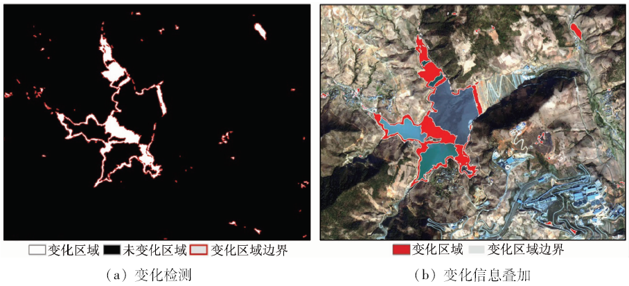
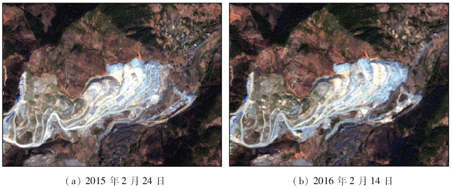
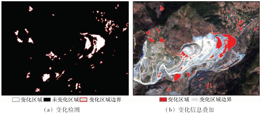
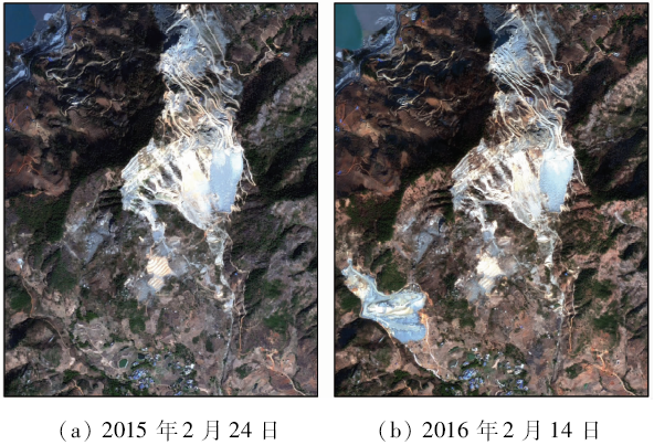
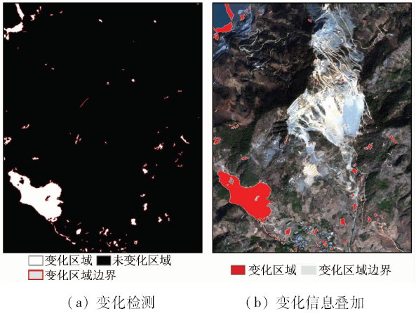
With the development of mine monitoring technology towards the quantification and automation, the traditional remote sensing technology based on visual interpretation is not suitable for mine monitoring. In order to improve the automation of mine remote sensing monitoring and make up for deficiencies in traditional monitoring methods, the authors constructed an object-based change detection method with high degree of automation for dynamic monitoring of mine and the surrounding environment based on GF-2 remote sensing images. The method automatically selected training samples based on change vector analysis (CVA) and extracted change information by using extreme learning machine (ELM). The experimental results show that the detection accuracy of this method is 98.73%, and it can be used in the dynamic monitoring and analysis of mine environment with highly automation. Taking the typical mine and tailings pond in Miyi County of Sichuan Province as examples, the authors carried out the dynamic monitoring of mines and the surrounding areas based on GF-2 remote sensing images. The changes of mine and its surroundings were accurately detected, which verifies the feasibility of the method and provides examples for large-scale remote sensing monitoring in mine.
Zhang K, Ma S B, Liu L P . Remote sensing monitoring of the mineral resources exploration and mining environment of the salt lake based on SPOT5 data[J]. Remote Sensing for Land and Resources, 2012,24(3):146-153.doi: 10.6046/gtzyyg.2012.03.26.
[2]
Rogan J, Franklin J, Roberts D A . A comparison of methods for monitoring multitemporal vegetation change using Thematic Mapper imagery[J]. Remote Sensing of Environment, 2002,80(1):143-156.
doi: 10.1016/S0034-4257(01)00296-6
Lu Y G, Liu C, Wang J . Integrated solutions for mine remote sensing monitoring based on domestic satellite images:A case study of Tibet[J]. Remote Sensing for Land and Resources, 2014,26(4):85-90.doi: 10.6046/gtzyyg.2014.04.14.
An Z H, Nie H F, Wang H , et al. Study and analysis of application of ZY-1 02C satellite data to remote sensing monitoring technology for exploration of mineral resources[J]. Remote Sensing for Land and Resources, 2015,27(2):174-182.doi: 10.6046/gtzyyg.2015.02.27.
Wei J L, Zhou Y Z, Shao H Y , et al. Remote sensing monitoring of mine based on data of GF-1 - in the case of Huili polymetallic mining area[J]. Nonferrous Metals (Mine Section), 2016,68(4):86-91.
[6]
Roy M, Ghosh S, Ghosh A . A novel approach for change detection of remotely sensed images using semi-supervised multiple classifier system[J]. Information Sciences, 2014,269:35-47.
doi: 10.1016/j.ins.2014.01.037
Chang F Z, Zhao Y D, Liu S L . CUDA parallel algorithm for CVA change detection of remote sensing imagery[J]. Journal of Remote Sensing, 2016,20(1):114-128.
Huang W, Huang J L, Wang L H , et al. Remote sensing image change detection based on change vector analysis of PCA component[J]. Remote Sensing for Land and Resources, 2016,28(1):22-27.doi: 10.6046/gtzyyg.2016.01.04.
[9]
Wang R, Kwong S, Wang X Z , et al. Segment based decision tree induction with continuous valued attributes[J]. IEEE Transactions on Cybernetics, 2015,45(7):1262-1275.
doi: 10.1109/TCYB.2014.2348012
pmid: 25291806
[10]
Tan K, Li E Z, Du Q , et al. An efficient semi-supervised classification approach for hyperspectral imagery[J]. ISPRS Journal of Photogrammetry and Remote Sensing, 2014,97:36-45.
doi: 10.1016/j.isprsjprs.2014.08.003
[11]
Tan K, Jin X, Plaza A , et al. Automatic change detection in high-resolution remote sensing images by using a multiple classifier system and spectral-spatial features[J]. IEEE Journal of Selected Topics in Applied Earth Observations and Remote Sensing, 2016,9(8):3439-3451.
doi: 10.1109/JSTARS.2016.2541678
[12]
Li W, Chen C, Su H J , et al. Local binary patterns and extreme learning machine for hyperspectral imagery classification[J]. IEEE Transactions on Geoscience and Remote Sensing, 2015,53(7):3681-3693.
doi: 10.1109/TGRS.2014.2381602
[13]
Samat A, Du P J, Liu S C , et al. E 2LMs:Ensemble extreme learning machines for hyperspectral image classification [J]. IEEE Journal of Selected Topics in Applied Earth Observations and Remote Sensing, 2014,7(4):1060-1069.
doi: 10.1109/JSTARS.4609443
[14]
Hussain M, Chen D M, Cheng A , et al. Change detection from remotely sensed images: From pixel-based to object-based approaches[J]. ISPRS Journal of Photogrammetry and Remote Sensing, 2013,80:91-106.
doi: 10.1016/j.isprsjprs.2013.03.006
Zhang S, Chen J F, Gong J Z . Object-oriented classification based on C5.0 algorithm[J]. Science of Surveying and Mapping, 2016,41(6):117-121,125.
[16]
Huo C L, Zhou Z X, Lu H Q , et al. Fast object-level change detection for VHR images[J]. IEEE Geoscience and Remote Sensing Letters, 2010,7(1):118-122.
doi: 10.1109/LGRS.2009.2028438
 2018, Vol. 30
  ), 贾虎军2,3, 唐尧2,3, 马国超2,3