Please wait a minute...
 
国土资源遥感  2018, Vol. 30 Issue (3): 159-166    DOI: 10.6046/gtzyyg.2018.03.22
     本期目录 | 过刊浏览 | 高级检索 |
青海湖流域景观格局空间粒度效应分析
翟俊1, 侯鹏1, 赵志平2, 肖如林1(), 颜长珍3, 聂学敏4
1. 环境保护部卫星环境应用中心,北京 100094
2. 中国环境科学研究院,北京 100012
3. 中科院寒区旱区环境与工程研究所,兰州 730000
4. 青海省生态环境遥感监测中心,西宁 810007
An analysis of landscape pattern spatial grain size effects in Qinghai Lake watershed
Jun ZHAI1, Peng HOU1, Zhiping ZHAO2, Rulin XIAO1(), Changzhen YAN3, Xuemin NIE4
1. Satellite Environment Center, Ministry of Environmental Protection, Beijing 100094, China
2. Chinese Research Academy of Environmental Sciences, Beijing 100012, China
3. Cold and Arid Regions Environmental and Engineering Research Institute, Chinese Academy of Sciences, Lanzhou 730000, China
4. Ecological and Environmental Monitoring Center of Remote Sensing of Qinghai Province, Xining 810007, China
全文: PDF(6822 KB)   HTML  
输出: BibTeX | EndNote (RIS)      
摘要 

流域是生态系统的基本单元和重要空间尺度单元,流域尺度景观格局分析的科学性很大程度上依赖于最佳空间粒度的选取是否准确。选择青海湖流域为研究区,基于卫星遥感数据资料,利用面向对象分类方法,解译获得流域景观数据,通过重采样得到不同空间粒度的流域景观数据,计算得到不同景观格局指数并绘制各指数与空间粒度之间的关系曲线,识别景观格局指数的尺度效应,评估空间粒度增加而引起的景观格局指数信息损失量,确定流域尺度景观格局分析的最佳空间粒度。结果表明: 流域景观格局指数随着空间粒度增大变化显著,但规律不同; 综合景观指数的空间粒度效应和信息损失量变化特征,流域景观格局分析的最佳空间粒度选择以90 m为最佳。

服务
把本文推荐给朋友
加入引用管理器
E-mail Alert
RSS
作者相关文章
翟俊
侯鹏
赵志平
肖如林
颜长珍
聂学敏
关键词 流域尺度景观格局最佳粒度    
Abstract

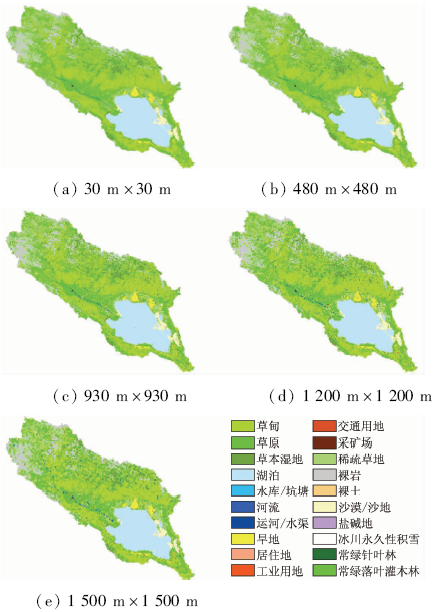
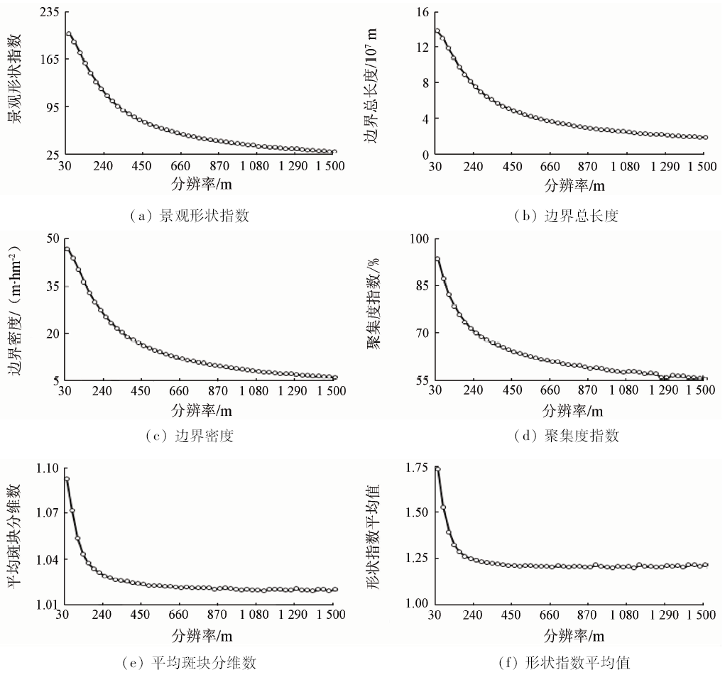
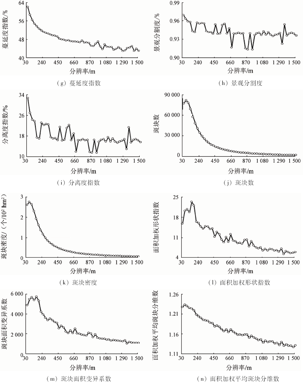
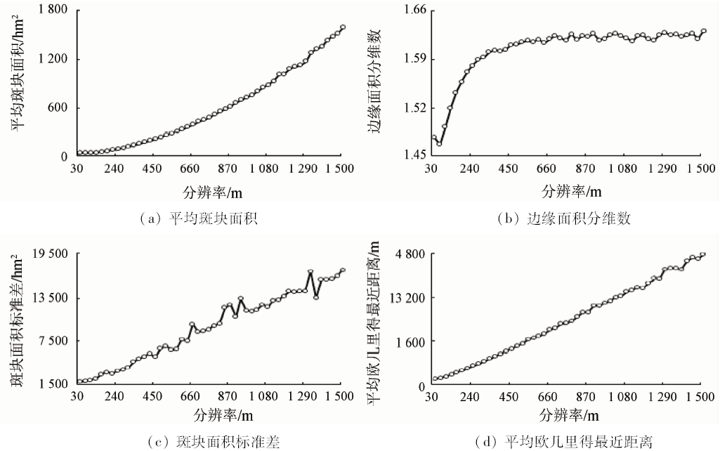
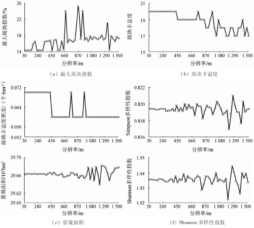
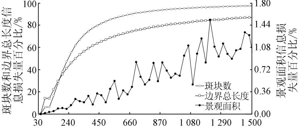
Watershed is the basic and important spatial scale unit of ecosystem. The scientific analysis of watershed scale landscape pattern depends heavily on the accuracy of the selection of the optimal grain size. In this paper, Qinghai Lake watershed was selected as the study area. Based on the object-oriented classification method, the authors interpreted satellite remote sensing data to generate watershed landscape data. Resampling method was used to obtain different spatial grain size watershed landscape data. Then the landscape pattern indexes were calculated and statistical relation curve was drawn between each landscape pattern index and grain size. Thus the scale effect of landscape pattern index could be identified. Finally, landscape pattern index information loss caused by increasing grain size was used to determine the optimum spatial grain size of watershed scale landscape pattern analysis. The result showed watershed landscape pattern index changed significantly with the increase of spatial grain size, but laws of change were different. Taking into account the landscape pattern spatial grain size effect and the change characteristics of information loss, the authors hold that the best spatial grain size choice of watershed landscape pattern analysis was 90 m.

Key wordswatershed    scale    landscape pattern    optimal grain size
收稿日期: 2017-03-27      出版日期: 2018-09-10
:  TP79  
基金资助:国家重点研发计划“重大生态工程生态效益监测与评估”(2017YFC0506506);“基于多源数据融合的生态系统评估技术及其应用研究”(2016YFC0500206)
通讯作者: 肖如林
作者简介: 翟 俊(1985-),男,博士,高级工程师,主要研究方向为环境遥感应用。Email: zhaij@lreis.ac.cn。
引用本文:   
翟俊, 侯鹏, 赵志平, 肖如林, 颜长珍, 聂学敏. 青海湖流域景观格局空间粒度效应分析[J]. 国土资源遥感, 2018, 30(3): 159-166.
Jun ZHAI, Peng HOU, Zhiping ZHAO, Rulin XIAO, Changzhen YAN, Xuemin NIE. An analysis of landscape pattern spatial grain size effects in Qinghai Lake watershed. Remote Sensing for Land & Resources, 2018, 30(3): 159-166.
链接本文:  
https://www.gtzyyg.com/CN/10.6046/gtzyyg.2018.03.22      或      https://www.gtzyyg.com/CN/Y2018/V30/I3/159
Fig.1  青海湖流域地理位置
Fig.2  青海湖流域不同空间粒度景观举例
景观格局指数 拟合函数 函数模型 R2
景观形状指数 幂函数 y = 352.61x-0.628 0.959 4
边界总长度 幂函数 y = 2e+8x-0.645 0.957 4
边界密度 幂函数 y = 82.876x-0.645 0.957 4
聚集度指数 幂函数 y = 93.324x-0.137 0.994 6
平均斑块分维数 幂函数 y = 1.064 6x-0.013 0.770 5
形状指数平均值 幂函数 y = 1.465 7x-0.059 0.653 9
蔓延度指数 幂函数 y = 62.387x-0.093 0.974 3
景观分割度 幂函数 y = 0.966 7x-0.009 0.397 2
分离度指数 幂函数 y = 28.556x-0.167 0.502 1
斑块数 幂函数 y = 319 685x-1.246 0.933 9
斑块密度 幂函数 y = 10.78x-1.246 0.933 9
面积加权形状指数 幂函数 y = 33.778x-0.411 0.808 7
斑块面积变异系数 幂函数 y = 10 600x-0.541 0.878 3
面积加权平均
斑块分维数
幂函数 y = 1.270 4x-0.029 0.927 2
平均斑块面积 二次函数 y = 0.519 8x2 +
5.711 1x + 12.88
0.999 4
边缘面积分维数 对数函数 y = 0.040 8lnx +
1.483 1
0.820 9
斑块面积标准差 线性函数 y = 322x + 1 252.1 0.974 7
平均欧几里得
最近距离
线性函数 y = 95.658x - 69.067 0.997 6
Tab.1  主要景观格局指数及其空间粒度变化的拟合函数
Fig.3-1  典型景观格局指数的空间粒度效应曲线(幂函数型)
Fig.3-2  典型景观格局指数的空间粒度效应曲线(幂函数型)
Fig.4  典型景观格局指数的空间粒度效应曲线(二次函数、对数函数、线性函数型)
Fig.5  典型景观格局指数的空间粒度效应曲线(分段函数、稳定且变化幅度增大型)
Fig.6  空间粒度效应引起的景观格局指数信息损失
[1] 侯鹏, 王桥, 王昌佐 , 等. 流域土地利用/土地覆被变化的生态效应[J] 地理研究, 2011,30(11):2092-2098.
Hou P, Wang Q, Wang C Z , et al. Ecological effect of land-use and land-cover change in a watershed scope[J] Geographical Research, 2012,30(11):2092-2098.
[2] 邬建国 . 景观生态学中的十大研究论题[J]. 生态学报, 2002,24(9):2074-2076.
doi: 10.3321/j.issn:1000-0933.2004.09.033
Wu J G . The key research topics in landscape ecology[J]. Acta Ecologica Sinica, 2002,24(9):2074-2076.
[3] Gustafson E J . Quantifying landscape spatial pattern:What is the state of the art?[J]. Ecosystems, 1998,1(2):143-156.
doi: 10.1007/s100219900011
[4] 张娜 . 生态学中的尺度问题:内涵与分析方法[J]. 生态学报, 2006,26(7):2340-2355.
Zhang N . Scale issues in ecology:Concepts of scale and scale analysis[J]. Acta Ecologica Sinica, 2006,26(7):2340-2355.
[5] 邬建国 . 景观生态学——格局、过程、尺度与等级[M]. 2版.北京: 高等教育出版社, 2007: 95-152.
Wu J G .Landscape Ecology Pattern, Process,Scale and Hierarchy[M].2nd ed. Beijing: Higher Education Press, 2007: 95-152.
[6] 宗秀影, 刘高焕, 乔玉良 , 等. 黄河三角洲湿地景观格局动态变化分析[J]. 地球信息科学学报, 2009,11(1):91-97.
doi: 10.3969/j.issn.1560-8999.2009.01.014
Zong X Y, Liu G H, Qiao Y L , et al. Study on dynamic changes of wetland landscape pattern in Yellow River delta[J]. Journal of Geo-Information Science, 2009,11(1):91-97.
[7] 张帅, 邵全琴, 刘纪远 , 等. 黄河源区玛多县土地利用/覆被及景观格局变化的遥感分析[J]. 地球信息科学, 2007,9(4):109-115,128.
Zhang S, Shao Q Q, Liu J Y , et al. Land use and landscape pattern change in Madoi County,the source region of Yellow River[J]. Geo-Information Science, 2007,9(4):109-115,128.
[8] 毕如田, 高艳 . 典型地貌景观指数的多尺度效应分析——以山西省运城市为例[J]. 地球信息科学学报, 2012,14(3):338-343.
doi: 10.3724/SP.J.1047.2012.00338
Bi R T, Gao Y . Analysis of multi-scale effect of landscape indices of classical landforms in Yuncheng City,Shanxi Province[J]. Journal of Geo-Information Science, 2012,14(3):338-343.
[9] 郭冠华, 陈颖彪, 魏建兵 , 等. 粒度变化对城市热岛空间格局分析的影响[J]. 生态学报, 2012,32(12):3764-3772.
doi: 10.5846/stxb201107181068
Guo G H, Chen Y B, Wei J B , et al. Impacts of grid sizes on urban heat island pattern analysis[J]. Acta Ecologica Sinica, 2012,32(12):3764-3772.
[10] 孙晓宇, 苏奋振, 吕婷婷 , 等. 珠江口西岸土地利用景观格局变化及驱动力分析[J]. 地球信息科学学报, 2009,11(4):436-441.
doi: 10.3969/j.issn.1560-8999.2009.04.005
Sun X Y, Su F Z, Lyu T T , et al. Analysis on landscape spatial pattern changes of land use and its driving forces in coastal zone of western Pearl River estuary[J]. Journal of Geo-Information Science, 2009,11(4):436-441.
[11] 王思远, 刘纪远, 张增祥 , 等. 近10年中国土地利用格局及其演变[J]. 地理学报, 2002,57(5):523-530.
doi: 10.3321/j.issn:0375-5444.2002.05.003
Wang S Y, Liu J Y, Zhang Z X , et al. Spatial pattern change of land use in China in recent 10 years[J]. Acta Geographica Sinica, 2002,57(5):523-530.
[12] 申卫军, 邬建国, 林永标 , 等. 空间粒度变化对景观格局分析的影响[J]. 生态学报, 2003,23(12):2506-2519.
doi: 10.3321/j.issn:1000-0933.2003.11.003
Shen W J, Wu J G, Lin Y B , et al. Effects of changing grain size on landscape pattern analysis[J]. Acta Ecologica Sinica, 2003,23(12):2506-2519.
[13] Turner M G, O’Neill R V,Gardner R H ,et al.Effects of changing spatial scale on the analysis of landscape pattern[J]. Landscape Ecology, 1989,3(3/4):153-162.
doi: 10.1007/BF00131534
[14] Wu J G, Shen W J, Sun W Z , et al. Empirical patterns of the effects of changing scale on landscape metrics[J]. Landscape Ecology, 2002,17(8):761-782.
doi: 10.1023/A:1022995922992
[15] Wu J G . Effects of changing scale on landscape pattern analysis:Scaling relations[J]. Landscape Ecology, 2004,19(2):125-138.
doi: 10.1023/B:LAND.0000021711.40074.ae
[16] 于磊, 赵彦伟, 张远 , 等. 基于最佳分析粒度的大辽河流域湿地景观格局分析[J]. 环境科学学报, 2011,31(4):873-879.
Yu L, Zhao Y W, Zhang Y , et al. Landscape pattern analysis of wetlands in the Daliaohe Watershed,based on optimal grain size[J]. Acta Scientiae Circumstantiae, 2011,31(4):873-879.
[17] 郭琳, 宋戈, 张远景 , 等. 基于最佳分析粒度的巴彦县土地利用景观空间格局分析[J]. 资源科学, 2013,35(10):2052-2060.
Guo L, Song G, Zhang Y J , et al. Land-use spatial analysis for Bayan County based on optimal grain size[J]. Resources Science, 2013,35(10):2052-2060.
[18] 王艳芳, 沈永明, 陈寿军 , 等. 景观格局指数相关性的幅度效应[J], 生态学杂志, 2012,31(8):2091-2097.
Wang Y F, Shen Y M, Chen S J , et al. Range effect of the correlations among landscape metrics[J], Chinese Journal of Ecology, 2012,31(8):2091-2097.
[19] 游丽平, 林广发, 杨陈照 , 等. 景观指数的空间尺度效应分析——以厦门岛土地利用格局为例[J]. 地球信息科学, 2008,10(1):74-79.
You L P, Lin G F, Yang C Z , et al. The effects of spatial scales on landscape indices——A case study of the landuse pattern of Xiamen Island[J]. Geo-Information Science, 2008,10(1):74-79.
[20] 陈利顶, 傅伯杰, 徐建英 , 等. 基于"源-汇"生态过程的景观格局识别方法——景观空间负荷对比指数[J]. 生态学报, 2003,23(11):2406-2413.
doi: 10.3321/j.issn:1000-0933.2003.11.025
Chen L D, Fu B J, Xu J Y , et al. Location-weighted landscape contrast index:A scale independent approach for landscape pattern evaluation based on "Source-Sink" ecological processes[J]. Acta Ecologica Sinic, 2003,23(11):2406-2413.
[21] 崔步礼, 常学礼, 左登华 , 等. 沙地景观中矢量数据栅格化方法及尺度效应[J]. 生态学报, 2009,29(5):2463-2472.
Cui B L, Chang X L, Zuo D H , et al. Rasterizing vector data and its scaling effect for a sand landscape[J]. Acta Ecologica Sinic, 2009,29(5):2463-2472.
[22] 吕志强, 吴志峰, 张景华 . 基于最佳分析尺度的广州市景观格局分析[J]. 地理与地理信息科学, 2007,23(4):89-92.
Lyu Z Q, Wu Z F, Zhang J H . Landscape pattern analysis of Guangzhou based on optimization-scale[J]. Geography and Geo-Information Science, 2007,23(4):89-92.
[23] 郑建蕊, 蒋卫国, 周廷刚 , 等. 洞庭湖区湿地景观指数选取与格局分析[J]. 长江流域资源与环境, 2010,19(3):305-310.
Zheng J R, Jiang W G, Zhou T G , et al. Selection of wetland landscape indices and analysis of landscape pattern in Dongting Lake area[J]. Resources and Environment in the Yangtze Basin, 2010,19(3):305-310.
[24] 邢宇 . 青藏高原32年湿地对气候变化的空间响应[J]. 国土资源遥感, 2015,27(3):99-107.doi: 10.6046/gtzyyg.2015.03.17.
doi: 10.6046/gtzyyg.2015.03.17
Xing Y . Spatial responses of wetland change to climate in 32 years in Qinghai-Tibet Plateau[J]. Remote Sensing for Land and Resources, 2015,27(3):99-107.doi: 10.6046/gtzyyg.2015.03.17.
[25] 江波, 张路, 欧阳志云 . 青海湖湿地生态系统服务价值评估[J]. 应用生态学报, 2015,26(10):3137-3144.
Jiang B, Zhang L, Ouyang Z Y . Ecosystem services valuation of Qinghai Lake[J]. Chinese Journal of Applied Ecology, 2015,26(10):3137-3144.
[26] 姜翠红, 李广泳, 程滔 , 等. 青海湖流域生态服务价值时空格局变化及其影响因子研究[J]. 资源科学, 2016,38(8):1572-1584.
doi: 10.18402/resci.2016.08.15
Jiang C H, Li G Y, Cheng T , et al. Spatial-temporal pattern variation and impact factors of ecosystem service values in the Qinghai Lake Watershed[J]. Resources Science, 2016,38(8):1572-1584.
[27] 杨娅楠, 王金亮, 陈光杰 , 等. 抚仙湖流域土地利用格局与水质变化关系[J]. 国土资源遥感, 2016,28(1):159-165.doi: 10.6046/gtzyyg.2016.01.23.
doi: 10.6046/gtzyyg.2016.01.23
Yang Y N, Wang J L, Chen G J , et al. Relationship between land use pattern and water quality change in Fuxian Lake basin[J]. Remote Sensing for Land and Resources, 2016,28(1):159-165.doi: 10.6046/gtzyyg.2016.01.23.
[1] 江娜, 陈超, 韩海丰. 海岸带地类统计模型中DEM空间尺度优选方法[J]. 自然资源遥感, 2022, 34(1): 34-42.
[2] 吴琳琳, 李晓燕, 毛德华, 王宗明. 基于遥感和多源地理数据的城市土地利用分类[J]. 自然资源遥感, 2022, 34(1): 127-134.
[3] 方梦阳, 刘晓煌, 孔凡全, 李明哲, 裴小龙. 一种基于GEE平台制作逐年土地覆盖数据的方法——以黄河流域为例[J]. 自然资源遥感, 2022, 34(1): 135-141.
[4] 杜懿, 王大洋, 王大刚. GPM卫星降水产品空间降尺度研究——以贵州省为例[J]. 自然资源遥感, 2021, 33(4): 111-120.
[5] 李特雅, 宋妍, 于新莉, 周圆锈. 卫星热红外温度反演钢铁企业炼钢月产量估算模型[J]. 自然资源遥感, 2021, 33(4): 121-129.
[6] 王美雅, 徐涵秋. 中外超大城市热岛效应变化对比研究[J]. 自然资源遥感, 2021, 33(4): 200-208.
[7] 范田亿, 张翔, 黄兵, 钱湛, 姜恒. 湘江流域TRMM卫星降水产品降尺度研究与应用[J]. 自然资源遥感, 2021, 33(4): 209-218.
[8] 温银堂, 王铁柱, 王书涛, 王贵川, 刘诗瑜, 崔凯. 基于多尺度分割的高分辨率遥感影像镶嵌线自动提取[J]. 自然资源遥感, 2021, 33(4): 64-71.
[9] 于新莉, 宋妍, 杨淼, 黄磊, 张艳杰. 结合空间约束的卷积神经网络多模型多尺度船企场景识别[J]. 自然资源遥感, 2021, 33(4): 72-81.
[10] 杨雯娜, 周亮, 孙东琪. 基于分区-集成的黄河流域生态脆弱性评价[J]. 自然资源遥感, 2021, 33(3): 211-218.
[11] 杨蕴雪, 张艳芳. 基于空间距离指数的延河流域生态敏感性时空演变特征[J]. 自然资源遥感, 2021, 33(3): 229-237.
[12] 朱瑜馨, 吴门新, 鲍艳松, 李鑫川, 张锦宗. FY-3D/MWRI L1B亮温LST反演与降尺度研究[J]. 自然资源遥感, 2021, 33(3): 27-35.
[13] 姜亚楠, 张欣, 张春雷, 仲诚诚, 赵俊芳. 基于多尺度LBP特征融合的遥感图像分类[J]. 自然资源遥感, 2021, 33(3): 36-44.
[14] 王华, 李卫卫, 李志刚, 陈学业, 孙乐. 基于多尺度超像素的高光谱图像分类研究[J]. 自然资源遥感, 2021, 33(3): 63-71.
[15] 刘万军, 高健康, 曲海成, 姜文涛. 多尺度特征增强的遥感图像舰船目标检测[J]. 自然资源遥感, 2021, 33(3): 97-106.
Viewed
Full text


Abstract

Cited

  Shared   
  Discussed   
京ICP备05055290号-2
版权所有 © 2015 《自然资源遥感》编辑部
地址:北京学院路31号中国国土资源航空物探遥感中心 邮编:100083
电话:010-62060291/62060292 E-mail:zrzyyg@163.com
本系统由北京玛格泰克科技发展有限公司设计开发