Please wait a minute...
 
国土资源遥感  2018, Vol. 30 Issue (3): 230-237    DOI: 10.6046/gtzyyg.2018.03.31
     本期目录 | 过刊浏览 | 高级检索 |
基于多源遥感数据西藏山南地区活动断层解译
王阳明1,2, 张景发2, 刘智荣1, 申旭辉2
1. 防灾科技学院,河北 065201
2. 中国地震局地壳应力研究所,北京 100085
Active faults interpretation of Shannan area in Tibet based on multi-source remote sensing data
Yangming WANG1,2, Jingfa ZHANG2, Zhirong LIU1, Xuhui SHEN2
1. Institute of Disaster Prevention, Hebei 065201, China
2. Institute of Crustal Dynamics, CEA, Beijing 100085, China
全文: PDF(12193 KB)   HTML  
输出: BibTeX | EndNote (RIS)      
摘要 

利用多源遥感数据从多尺度重新对西藏山南地区活动断层进行遥感解译,并综合前人研究成果对其位置及活动性进行判定。首先,采用具有全天候和穿透性的Sentinel-1雷达图像和光谱信息丰富的Landsat ETM+影像作为主要数据源,并结合高空间分辨率的高分二号遥感影像,提取并分析不同尺度的地质构造信息; 其次,将DEM数据与ETM+遥感影像进行融合,获取三维可视化遥感影像,方便从不同角度、不同层次进行活动断层的构造地貌分析; 最后,综合雷达遥感与光学遥感各自的成像优势,利用图像预处理、图像增强处理与多源遥感图像融合等处理来降低活动断层遥感解译的多解性与可疑性,明晰了西藏山南研究区的活动断层遥感影像特征。根据活动断层遥感解译标志,在研究区共解译出主要活动断裂带4条,分别为: 雅鲁藏布江断裂带、札达—拉孜—邛多江断裂带、桑日—错那断裂带和达吉岭—昂仁—仁布断裂带。研究区的活动断层解译结果表明,综合应用多源遥感数据可以大大提高活动断层解译的准确率与可信度,并为研究区后续研究提供借鉴。

服务
把本文推荐给朋友
加入引用管理器
E-mail Alert
RSS
作者相关文章
王阳明
张景发
刘智荣
申旭辉
关键词 西藏山南地区多源遥感数据活动断层解译    
Abstract

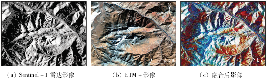
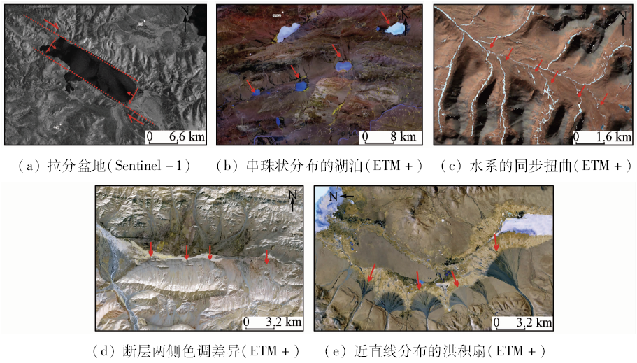
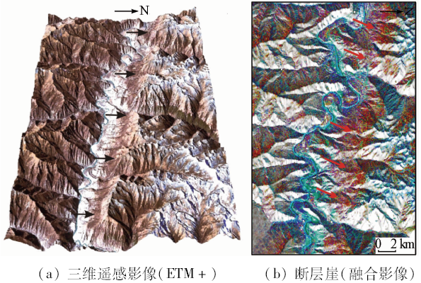
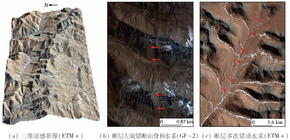
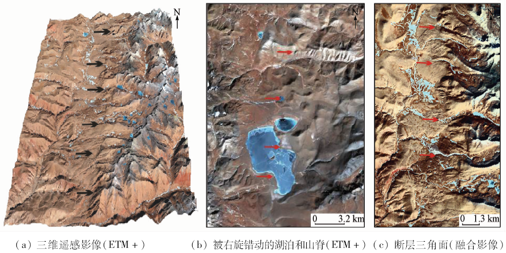
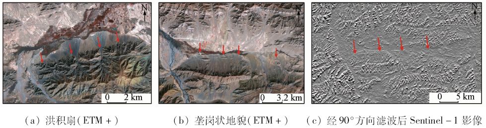
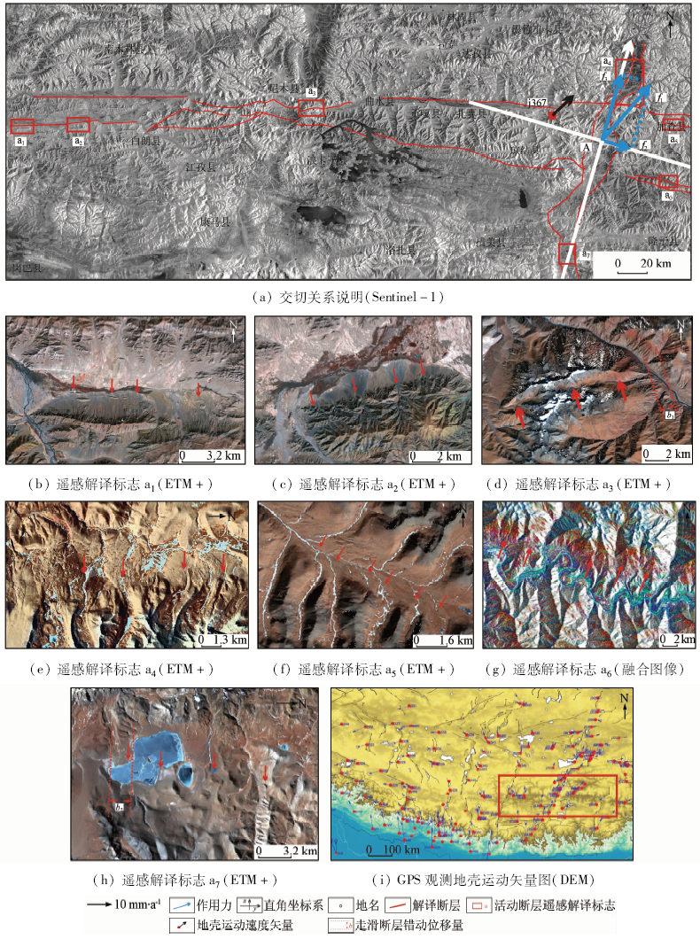
The remote sensing interpretation of active faults in Shannan region of Tibet was carried out by using multi-source remote sensing data, which showed remarkable difference from previous work. In addition, previous researches made by other people were used to study the distribution and activity of active faults synthetically. First, taking Sentinel-1 Radar images which have properties of all-weather, side looking and penetrating and Landsat ETM+ images that have abundant spectral information as master data sources, combined with high resolution GF-2 remote sensing image, the authors extracted and analyzed geological structure information at different scales. What is more, it was convenient to analyze tectonic geomorphology of active faults from different angles and levels with the help of the fusion of DEM data and ETM+ remote sensing images so as to make 3D visualization remote sensing images. Finally, the authors used a wide range of methods such as image preprocessing, image enhancement and multi-source remote sensing image fusion to reduce the multiple solutions and dubiety of active fault remote sensing interpretation. With the help of Radar and optical remote sensing respective imaging advantages, the authors clearly displayed the characteristics of active fault remote sensing image of the study area. According to the remote sensing interpretation marks of active faults, a total of 4 active faults were interpreted in the study area: the Yarlung Zangbo River fault, the Zanda-Lhaze-Qiongduojiang fault, the Sangri-Cona fault and the Darjeeling-Ngamring-Rinbung fault. The results of active fault interpretation in the study area show that the application of multi-source remote sensing data could greatly improve the accuracy and credibility of the interpretation of active faults and provide a reference for later researches on the study area.

Key wordsShannan area in Tibet    multi-source remote sensing data    active fault interpretation
收稿日期: 2017-03-29      出版日期: 2018-09-10
:  TP79  
基金资助:中国地震局地壳应力研究所中央级公益性科研院所基本科研业务专项项目“结合D-InSAR和建筑物结构模型的震害建筑物定量评估”(ZDJ2017-29)
作者简介: 王阳明(1990-),男,硕士研究生,主要从事遥感地质方面的研究。Email: wojiaowangyangming@163.com。
引用本文:   
王阳明, 张景发, 刘智荣, 申旭辉. 基于多源遥感数据西藏山南地区活动断层解译[J]. 国土资源遥感, 2018, 30(3): 230-237.
Yangming WANG, Jingfa ZHANG, Zhirong LIU, Xuhui SHEN. Active faults interpretation of Shannan area in Tibet based on multi-source remote sensing data. Remote Sensing for Land & Resources, 2018, 30(3): 230-237.
链接本文:  
https://www.gtzyyg.com/CN/10.6046/gtzyyg.2018.03.31      或      https://www.gtzyyg.com/CN/Y2018/V30/I3/230
Fig.1  研究区地质构造简图
Fig.2  GS光谱锐化融合
Fig.3  线状构造解译标志
Fig.4  雅鲁藏布江断裂带加查县附近断层三维遥感影像
Fig.5  札达—拉孜—邛多江断裂带三维遥感影像及断层左旋错断山脊和水系
Fig.6  桑日—错那断裂带三维遥感影像及被错动的湖泊和山脊
Fig.7  断层位置确定
序号 编号 断层名称 走向 性质 长度/km
1 F1 雅鲁藏布江断裂带 EW 正断层 南倾 330
2 F2 札达—拉孜—邛多江断裂带 近WNW 走滑
断层
左旋 220
3 F3 桑日—错那断裂带 总体为近NW的波状 走滑
断层
右旋,部分区域发育有正断层 120
4 F4 达吉岭—昂仁—仁布断裂带 EN转EW 逆断
部分区域为隐伏断层,南倾 64
Tab.1  研究区主要活动断层解译
Fig.8  研究区活动断层遥感解译(ETM+)
Fig.9  研究区内主要活动断层交切关系
Fig.10  拉分盆地受力分析(ETM+)
[1] 郭慧, 王鑫 . 河北隆尧现今地裂缝与1966年邢台地震关系[J]. 华北地震科学, 2017,35(1):10-16.
Guo H, Wang X . Relationship between the present-day ground fissure in Hebei Longyao and the 1966 Xingtai earthquake[J]. North China Earthquake Sciences, 2017,35(1):10-16.
[2] 郭慧, 江娃利, 谢新生 . 1976年唐山Ms7.8地震乐亭—滦南地区NW向地裂缝带赵滩点位调查[J]. 地震学报, 2016,38(4):644-655.
Guo H, Jiang W L, Xie X S . Investigation on Zhaotan site in NW-trending ground fissure zone of 1976 Ms7.8 Tangshan earthquake in Laoting-Luannan region[J]. Acta Seismologica Sinica, 2016,38(4):644-655.
[3] 徐锡伟, 闻学泽, 叶建青 , 等. 汶川Ms8.0地震地表破裂带及其发震构造[J]. 地震地质, 2008,30(3):597-629.
Xu X W, Wen X Z, Ye J Q , et al. The Ms8.0 Wenchuan earth-quake surface ruptures and its seismogenic structure[J]. Seismology and Geology, 2008,30(3):597-629.
[4] 张建毅, 薄景山, 袁一凡 , 等. 活动断层及其避让距离研究综述[J]. 自然灾害学报, 2012,21(2):9-18.
Zhang J Y, Bo J S, Yuan Y F , et al. Review of research on active fault and its setback[J]. Journal of Natural Disasters, 2012,21(2):9-18.
[5] 谢广林 . 中国活动断裂遥感信息分析[M]. 北京: 地震出版社, 2000, 1-18.
Xie G L , Remote sensing information analysis of active faults in China[M]. Beijing: Seismological Press, 2000, 1-18.
[6] 邓起东 . 活动断层的研究进展与方向[M] //国家地震局地质研究所.活动断层研究(1).北京: 地震出版社, 1991, 1-6.
Deng Q D. Research progress and direction of active faults[M] //Institute of Geology, China Earthquake Administration.Research of Active Faults(1).Beijing:Seismological Press, 1991, 1-6.
[7] 赵福岳, 张瑞江, 陈华 , 等. 青藏高原隆升的生态地质环境响应遥感研究[J]. 国土资源遥感, 2012,24(3):116-121.doi: 10.6046/gtzyyg.2012.03.21.
doi: 10.6046/gtzyyg.2012.03.21
Zhao F Y, Zhang R J, Chen H , et al. Study of Qinghai-Tibet Plateau uplift response to eco-geological environment based on remote sensing[J]. Remote Sensing for Land and Resources, 2012,24(3):116-121.doi: 10.6046/gtzyyg.2012.03.21.
[8] 朱菲菲 . 雅鲁藏布江中游谢通门南北向活动断层带特征及工程效应研究[D]. 成都:成都理工大学, 2008.
Zhu F F . The research of the North-South active fault belt in Xiatongmoin in the middle reaches of the Yarlung Zangbo River and effection engineering[D]. Chengdu:Chengdu University of Technology, 2008.
[9] 王瑜, 李齐, 万景林 , 等. 西藏南部地区南北向构造的形成及动力学探讨[J]. 地震地质, 2000,22:117-124.
Wang Y, Li Q, Wan J L , et al. Formation and dynamic analysis of NS trending structures in southern Tibet[J]. Seismology and Geology, 2000,22:117-124.
[10] Yin A . Cenozoic tectonic evolution of Asia:A preliminary synjournal[J]. Tectonophysics, 2010,488(1):293-325.
doi: 10.1016/j.tecto.2009.06.002
[11] 潘桂棠, 丁俊, 姚东生 , 等. 青藏高原及邻区地质图说明书(1∶1 500 000)[M]. 成都: 成都地图出版社, 2004: 1-47.
Pan G T, Ding J, Yao D S , et al. Instructions of the Qinghai-Tibet Plateau and Adjacent Area Geological Map(1∶1 500 000)[M]. Chengdu: Chengdu Cartographic Publishing House, 2004: 1-47.
[12] 刘智荣, 黄静宜, 白相东 . 银川活动断层卫星遥感图像解译[J]. 防灾科技学院学报, 2012,14(1):17-25.
doi: 10.3969/j.issn.1673-8047.2012.01.004
Liu Z R, Huang J Y, Bai X D , Interpretation and analysis of the Yinchuan active faults based on satellite remote sensing images[J]. Journal of Institute of Disaster Prevention, 2012,14(1):17-25.
[13] 郑文俊, 郭华, 袁道阳 , 等. 遥感影像信息在活动断层研究中的应用[J]. 高原地震, 2002,14(2), 15-21.
doi: 10.3969/j.issn.1005-586X.2002.02.003
Zheng W J, Guo H, Yuan D Y , et al. Application of remote sensing image information in the research of active faults[J]. Earthquake Research in Plateau, 2002,14(2), 15-21.
[14] 张景发, 姜文亮, 田甜 , 等. 活动断层调查中的高分辨率遥感技术应用方法研究[J]. 地震学报, 2016,38(3):386-398.
doi: 10.11939/jass.2016.03.006
Zhang J F, Jiang W L, Tian T , et al. High resolution remote sensing application research in active fault surveying[J]. Acta Seismologica Sinica, 2016,38(3):386-398.
[15] 张培震, 王琪, 马宗晋 . 中国大陆现今构造运动的GPS速度场与活动地块[J]. 地学前缘, 2002,9(2):430-441.
Zhang P Z, Wang Q, Ma Z J . GPS velocity field and active crustal blocks of contemporary tectonic deformation in continental China[J]. Earth Science Frontiers, 2002,9(2):430-441.
[16] 刘小汉, 琚宜太, 韦利杰 , 等. 再论雅鲁藏布江缝合带构造模型[J]. 中国科学( D辑), 2009,39(4):448-463.
Liu X H, Qu Y T, Wei L J , et al. The discussion again of Yarlung Zangbo Suture Zone’s structural model[J]. Science China Earth Sciences, 2009,39(4):448-463.
[17] 贺日政, 高锐 . 西藏高原南北向裂谷研究意义[J]. 地球物理学进展, 2003,18(1):35-43.
doi: 10.3969/j.issn.1004-2903.2003.01.006
He R Z, Gao R . Some significances of studying north-southern rift in Tibet Plateau[J]. Progress in Geophysics, 2003,18(1):35-43.
[18] 吴珍汉, 叶培盛, 吴中海 , 等. 青藏铁路沿线断裂活动的灾害效应[J]. 现代地质, 2003,17(1):1-7.
doi: 10.3969/j.issn.1000-8527.2003.01.001
Wu Z H, Ye P S, Wu Z H , et al. Hazard effects of active faulting along the Golmud-Lhasa railway across the Tibetan Plateau[J]. Geoscience, 2003,17(1):1-7.
[1] 易佳思, 胡翔云. 基于Grabcut融合多源数据提取不透水面[J]. 国土资源遥感, 2018, 30(3): 174-180.
[2] 侯小刚, 郑照军, 李帅, 陈雪华, 崔宇. 近15年新疆逐日无云积雪覆盖产品生成及精度验证[J]. 国土资源遥感, 2018, 30(2): 214-222.
[3] 王俊霞, 朱秀芳, 刘宪锋, 潘耀忠. 基于多源遥感数据的旱情评价研究——以河南省为例[J]. 国土资源遥感, 2018, 30(1): 180-186.
[4] 董丽娜, 张微, 王雪, 陈玲, 杨金中, 莫子奋. 江西盛源火山盆地遥感地质解译与铀矿找矿前景分析[J]. 国土资源遥感, 2015, 27(4): 102-108.
[5] 刘新星, 陈建平, 曾敏, 代晶晶, 裴英茹, 任梦依, 王娜. 基于多源遥感数据的西藏羌多地区地质构造解译[J]. 国土资源遥感, 2015, 27(3): 154-160.
[6] 许旭, 郜昂, 朱萍萍, 周增科. 基于多源遥感数据的生态系统服务价值评估——以河北省为例[J]. 国土资源遥感, 2013, 25(4): 180-186.
[7] 李凤, 高昭良. 面向土地利用分类的多源遥感数据混合贝叶斯网络分类器[J]. 国土资源遥感, 2011, 23(2): 47-52.
Viewed
Full text


Abstract

Cited

  Shared   
  Discussed   
京ICP备05055290号-2
版权所有 © 2015 《自然资源遥感》编辑部
地址:北京学院路31号中国国土资源航空物探遥感中心 邮编:100083
电话:010-62060291/62060292 E-mail:zrzyyg@163.com
本系统由北京玛格泰克科技发展有限公司设计开发