1. International Institute for Earth System Science, Nanjing University, Nanjing 210023, China 2. Jiangsu Provincial Key Laboratory of Geographic Information Science and Technology, Nanjing 210023, China 3. Jiangsu Center for Collaborative Innovation in Geographical Information Resource Development and Application, Nanjing 210023, China
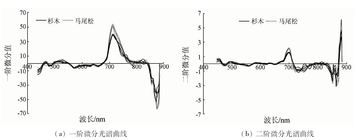
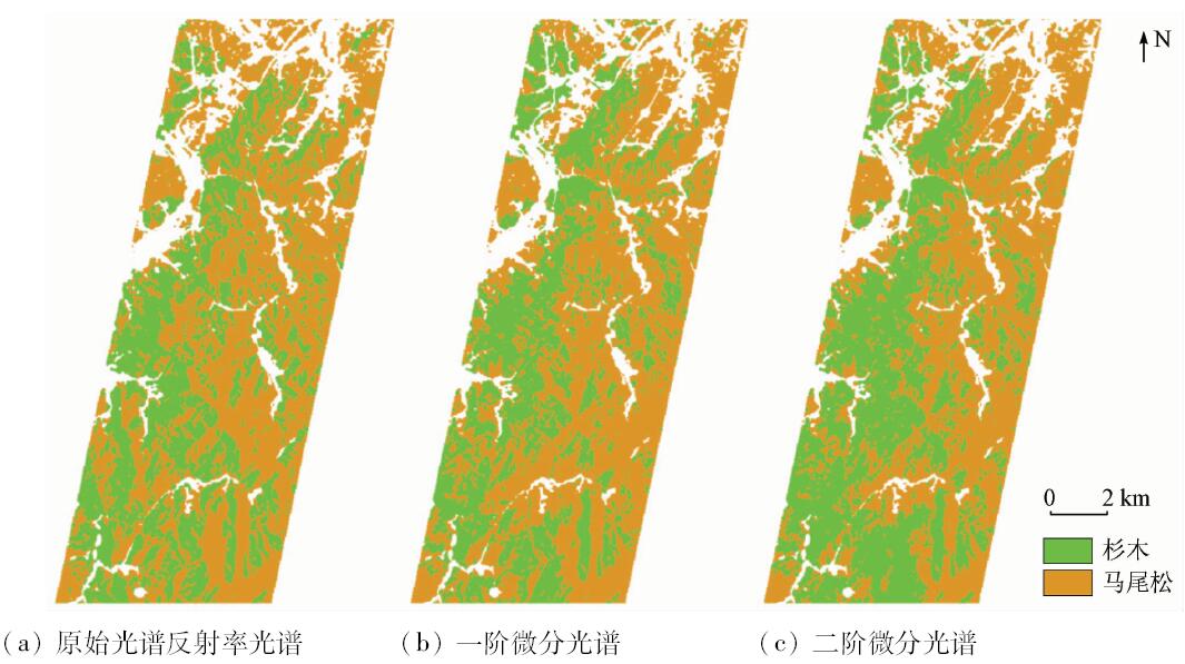
Hyperspectral remote sensing can distinguish small spectrum differences between ground objects, and is expected to solve the classification problem of tree species. In this paper, by using Hyperion hyperspectral image, combined with the ground measured samples, classification of Pinus massoniana and Cunninghamia lanceolata in Wucheng of Huangshan City was conducted. With the 1st and 2nd differential transformation of the image, spectral band combination of 487~559 nm and 681~742 nm differs significantly, and hence was chosen to conduct supervised classification using support vector machine. Classification accuracy of raw, 1st and 2nd differential transformation image reaches 76.50%, 81.42% and 88.52% with Kappa coefficient being 0.528 4, 0.625 7 and 0.769 1 respectively. The results show that 2nd differential transformation and band selection of hyperspectral data can improve the classification accuracy of Pinus massoniana and Cunninghamia lanceolata, thus providing a foundation for further study of classification of coniferous forest with hyperspectral remote sensing.
Ballanti L, Blesius L, Hines E , et al. Tree species classification using hyperspectral imagery:A comparison of two classifiers[J]. Remote Sensing. 2016,8(6):445.
doi: 10.3390/rs8060445
[2]
George R, Padalia H , Kushwaha S P S.Forest tree species discrimination in western Himalaya using EO-1 Hyperion[J]. International Journal of Applied Earth Observation and Geoinformation. 2014,28(1):140-149.
doi: 10.1016/j.jag.2013.11.011
[3]
Asadzadeh S, Roberto D S F C . A review on spectral processing methods for geological remote sensing[J]. International Journal of Applied Earth Observation and Geoinformation. 2016,47:69-90.
doi: 10.1016/j.jag.2015.12.004
Wang Z H, Ding L X . Tree species discrimination based on leaf-level hyperspectral characteristic analysis[J]. Spectroscopy and Spectral Analysis. 2010,30(7):1825-1829.
[5]
Clark M L, Roberts D A, Clark D B . Hyperspectral discrimination of tropical rain forest tree species at leaf to crown scales[J]. Remote Sensing of Environment. 2005,96(3):375-398.
doi: 10.1016/j.rse.2005.03.009
[6]
Peerbhay K Y, Mutanga O, Ismail R . Commercial tree species discrimination using airborne AISA Eagle hyperspectral imagery and partial least squares discriminant analysis (PLS-DA) in KwaZulu-Natal,South Africa[J]. ISPRS Journal of Photogrammetry and Remote Sensing. 2013,79(5):19-28.
doi: 10.1016/j.isprsjprs.2013.01.013
[7]
Heinzel J, Koch B . Investigating multiple data sources for tree species classification in temperate forest and use for single tree delineation[J]. International Journal of Applied Earth Observation and Geoinformation. 2012,18(18):101-110.
doi: 10.1016/j.jag.2012.01.025
[8]
Cho H, Lee K S . Comparison between hyperspectral and multispectral images for the classification of coniferous species[J]. Korean Journal of Remote Sensing. 2014,30(1):25-36.
doi: 10.7780/kjrs.2014.30.1.3
Zang Z, Lin H, Sun H , et al. Study on hyper-spectral dimension reduction and classification for main southern coniferous species[J]. Journal of Central South University of Forestry and Technology, 2010,30(11):20-25.
[10]
Plaza A, Benediktsson J A, Boardman J W , et al. Recent advances in techniques for hyperspectral image processing[J]. Remote Sensing of Environment. 2009,113(1):S110-S122.
doi: 10.1016/j.rse.2007.07.028
Ding H, Fang Y M, Yang X H , et al. Community characteristics of a subtropical evergreen broad-leaved forest in Huangshan,Anhui Province,East China[J]. Biodiversity Science. 2016,24(8):875-887.
[12]
Puletti N, Camarretta N, Corona P . Evaluating EO1-Hyperion capability for mapping conifer and broadleaved forests[J]. European Journal of Remote Sensing. 2016,49(1):157-169.
doi: 10.5721/EuJRS20164909
[13]
Scheffler D, Karrasch P. Preprocessing of hyperspectral images:A comparative study of destriping algorithms for EO1-Hyperion [C]//Proceedings of the International Society for Optical Engineering. 2013,8892(6):1504-1507.
[14]
Kuusk A, Lang M, Nilson T . Simulation of the reflectance of ground vegetation in sub-boreal forests[J]. Agricultural and Forest Meteorology. 2004,126(1):33-46.
doi: 10.1016/j.agrformet.2004.05.004
 2018, Vol. 30
  ), 申怀飞1,2, 徐凯健1,2