Effect of radio-frequency interference on the retrieval of land surface temperature from microwave radiation imager
Ying WU, Sulin JIANG, Zhenhui WANG
Key Laboratory of Meteorological Disaster, Ministry of Education (KLME)/ Joint International Research Laboratory of Climate and Environment Change (ILCEC)/ Collaborative Innovation Center on Forecast and Evaluation of Meteorological Disasters (CIC-FEMD)/Key Laboratory for Aerosol-Cloud-Precipitation of China Meteorological Administration, Nanjing University of Information Science and Technology, Nanjing 210044, China
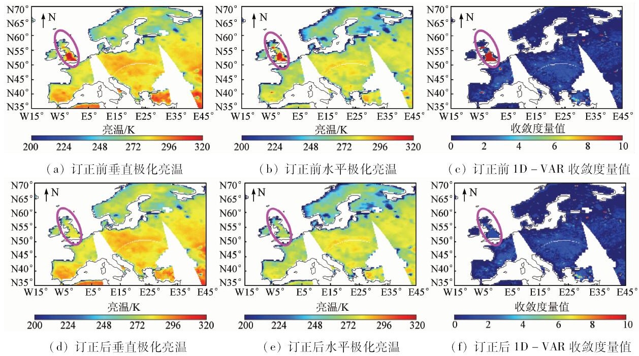
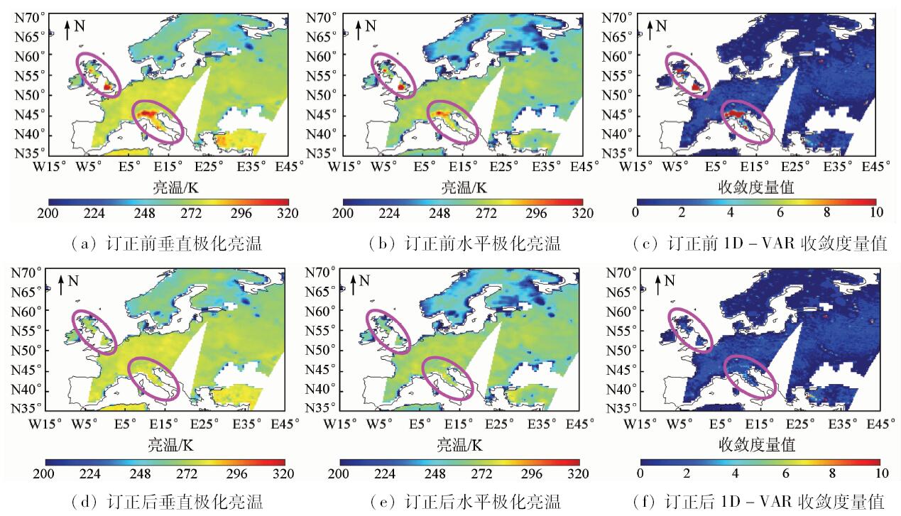
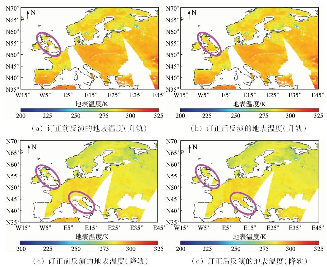
Radio-frequency interference (RFI) over European land was detected and analyzed using convergence metric of one dimensional variational retrieval (1D-VAR) method and then its influence on the retrieval of land surface temperature (LST) was studied based on FY-3B microwave radiation imager (MWRI) Level 1 measurements conducted. Next, two linear regression equations were proposed to correct RFI-contaminated MWRI data. By comparing the retrieved LST products through 1D-VAR method from MWRI measurements before and after RFI correction, it was found that the convergence metric of 1D-VAR analyzing RFI identification method was effective for the observations over the land. Moreover, retrieved LST which were interfered by RFI were abnormally high with large deviations. And the RFI correction algorithm was used effec tively to improve the inversion precision and the utilization ratio of microwave data. Therefore, it is necessary to effectively identify and correct RFI prior to low-frequency observations with spaceborne microwave imagers to retrieve LST.
吴莹, 姜苏麟, 王振会. 无线电频率干扰对MWRI资料反演地表温度的影响[J]. 国土资源遥感, 2018, 30(4): 90-96.
Ying WU, Sulin JIANG, Zhenhui WANG. Effect of radio-frequency interference on the retrieval of land surface temperature from microwave radiation imager. Remote Sensing for Land & Resources, 2018, 30(4): 90-96.
Zhang T J, Jin R, Gao F . Overview of the satellite remote sensing of frozen ground:Passive microwave sensors[J]. Advances in Earth Science, 2009,24(10):1073-1083.
Zhou F C, Song X N, Li Z L . Progress of land surface temperature retrieval based on passive microwave remote sensing[J]. Remote Sensing for Land and Resources, 2014,26(1):1-7.doi: 10.6046/gtzyyg.2014.01.01.
Liu J, Ma H Z, Yang L , et al. A survey of surface temperature retrieval by passive microwave remote sensing[J]. Remote Sensing Technology and Application, 2012,27(6):812-821.
Mao K B, Shi J C, Li Z L , et al. A physics-based statistical algorithm for retrieving land surface temperature from AMSR-E passive microwave data[J]. Science in China(series D)Earth Science, 2006,36(12):1170-1176.
Li Q, Zhong R F . Multiple surface parameters retrieval of simulated AMSR-E data[J]. Remote Sensing for Land and Resources, 2011,23(1):42-47.doi: 10.6046/gtzyyg.2011.01.08.
Wang Y W, Song X N, Tang B H , et al. Validation of FY-2C derived land surface temperature over the source region of the Yellow River:A case study of Maqu County[J]. Remote Sensing for Land and Resources, 2015,27(4):68-72.doi: 10.6046/gtzyyg.2015.04.11.
Wang Y H, Xiao Y . A temporal-spatial variation analysis of land surface temperature in Beijing[J]. Remote Sensing for Land and Resources, 2014,26(3):146-152.doi: 10.6046/gtzyyg.2014.03.24.
Mao K B, Shi J C, Li Z L , et al. The land surface temperature and emissivity retrieved from the AMSR passive microwave data[J]. Remote Sensing for Land and Resources, 2005,17(3):14-17.doi: 10.6046/gtzyyg.2005.03.04.
[10]
Li L, Njoku E G, Im E , et al. A preliminary survey of radio-frequency interference over the U.S. in Aqua AMSR-E data[J]. IEEE Transactions on Geoscience and Remote Sensing, 2004,42(2):380-390.
doi: 10.1109/TGRS.2003.817195
[11]
Li L.Gaiser P W, Bettenhausen M H , et al. WindSat radio-frequency interference signature and its identification over land and ocean[J]. IEEE Transactions on Geoscience and Remote Sensing, 2006,44(3):530-539.
doi: 10.1109/TGRS.2005.862503
[12]
Njoku E G, Ashcroft P, Chan T K , et al. Global survey and statistics of radio-frequency interference in AMSR-E land observations[J]. IEEE Transactions on Geoscience and Remote Sensing, 2005,43(5):938-947.
doi: 10.1109/TGRS.2004.837507
[13]
Lacava T, Coviello I, Faruolo M , et al. A multitemporal investigation of AMSR-E C-band radio-frequency interference[J]. IEEE Transactions on Geoscience and Remote Sensing, 2013,51(4), 2007-2015.
doi: 10.1109/TGRS.2012.2228487
[14]
Wu Y, Weng F Z . Detection and correction of AMSR-E radio-frequency interference[J]. Acta Meteorologica Sinica, 2011,25(5):669-681.
doi: 10.1007/s13351-011-0510-0
[15]
Wu Y, Weng F Z . Applications of an AMSR-E RFI detection and correction algorithm in 1D-VAR over land[J]. Journal of Meteorological Research, 2014,28(4):645-655.
doi: 10.1007/s13351-014-3075-x
[16]
Zou X L, Zhao J, Weng F Z , et al. Detection of radio-frequency interference signal over land from FY-3B microwave radiation imager(MWRI)[J]. IEEE Transactions on Geoscience and Remote Sensing, 2012,50(12):4994-5003.
doi: 10.1109/TGRS.2012.2191792
[17]
Zhao J, Zou X L, Weng F Z . WindSat radio-frequency interference signature and its identification over Greenland and Antarctic[J]. IEEE Transactions on Geoscience and Remote Sensing, 2013,51(9):4830-4839.
doi: 10.1109/TGRS.2012.2230634
Guan L, Zhang S B . Source analysis of radio-frequency interference over Europe land from advanced microwave scanning radiometer-E[J]. Acta Optica Sinica, 2014,34(7):277-283.
Zhang S B, Guan L . Effect of AMSR-E data interference on the retrieval of land surface parameters.[J]. China Environmental Science, 2015,35(1):260-268.
[20]
Boukabara S A, Garrett K, Chen W C , et al. MiRS:An all-weather 1DVAR satellite data assimilation and retrieval system[J]. IEEE Transactions on Geoscience and Remote Sensing, 2011,49(9):3249-3272.
doi: 10.1109/TGRS.2011.2158438
[21]
Weng F Z, Han Y, Delst P V, et al. JCSDA community radiative transfer model (CRTM) [C]//Proceedings 14th International ATOVS Study Conference. 2005: 217-222.
[22]
Yang H, Weng F Z, Lyu L Q , et al. The FengYun-3 microwave radiation imager on-orbit verication[J]. IEEE Transactions on Geoscience and Remote Sensing, 2011,49(11):4552-4560.
doi: 10.1109/TGRS.2011.2148200
 2018, Vol. 30