Spatial-temporal characteristics of vegetation phenology in Shaanxi Province based on MODIS time series
Hongzhu HAN1,2, Jianjun BAI1,2(), Bo ZHANG3, Gao MA3
1. School of Geography and Tourism, Shaanxi Normal University, Xi’an 710062, China; 2. National Demonstration Center for Experimental Geography Education, Shaanxi Normal University, Xi’an 710062, China; 3. China Academy of Space Technology Xi’an , Xi’an 710000, China;
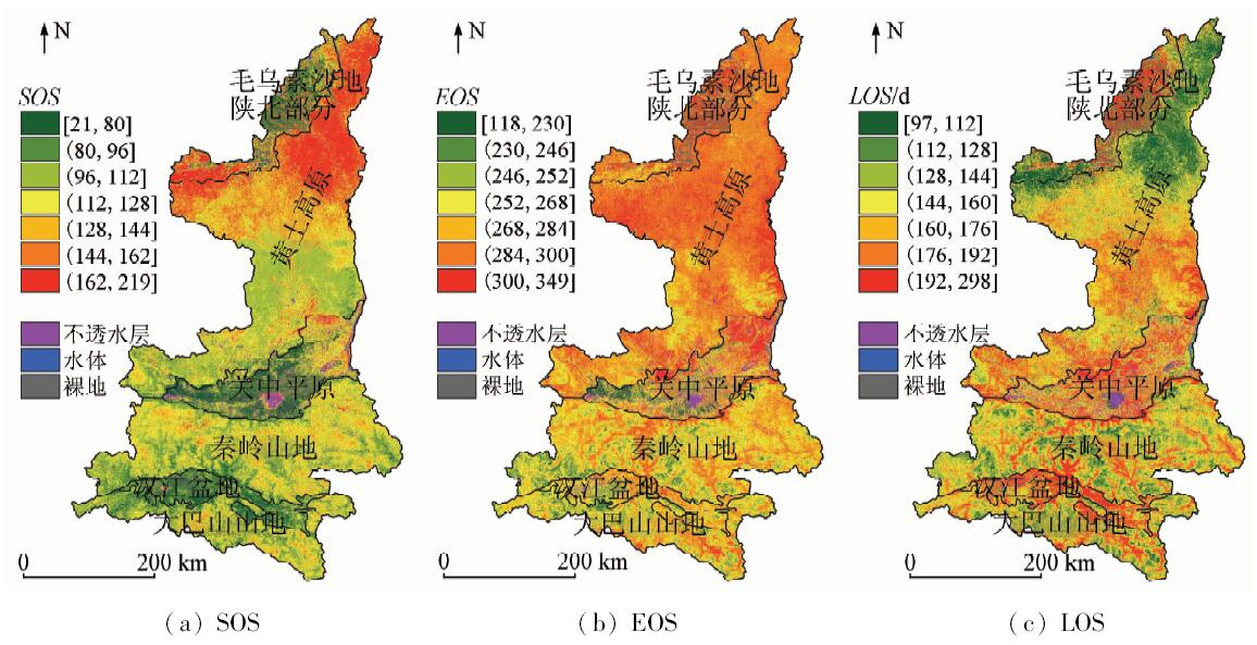
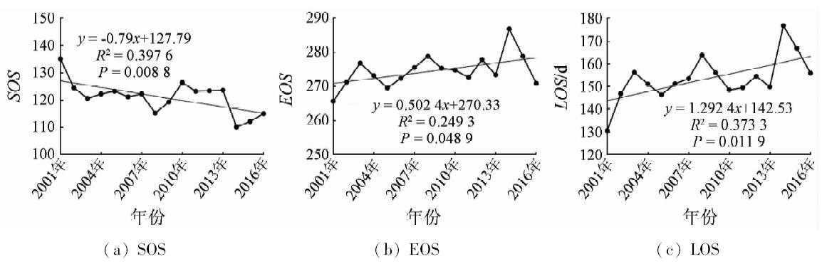
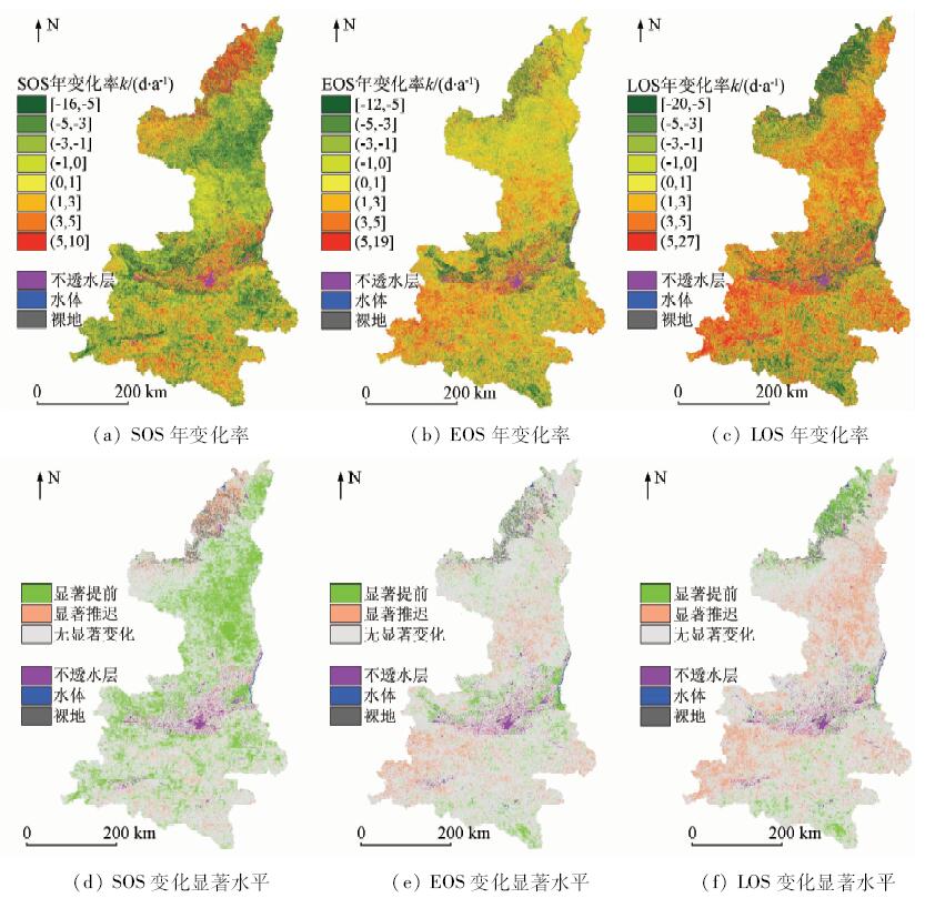
Remote sensing has been widely used in the study of natural geographical environment as an effective method to monitor the large-scale of surface. Among them, as a regular and periodic event in nature, vegetation phenology plays an important role in the natural environment, especially climate change. With Shaanxi Province as the study area and on the basis of the time series reconstruction of the MODIS NDVI data by using the Savitzky-Golay filtering method, the authors extracted and analyzed the vegetation phenology parameters of Shaanxi Province for the spatio-temporal changes from 2001 to 2016. The conclusions are as follows: ①The spatial distribution characteristics of vegetation phenology are in good agreement with the spatial distribution of different landforms in Shaanxi Province. ②The average start of season(SOS) was on the 120th day, the average end of season(EOS) was on the 280th day, and the average length of season(LOS) was 160 days; ③ From 2001 to 2016, the change of SOS was -0.79 d/a (R2=0.4, P<0.01) , the EOS was 0.50 d/a (R2=0.25, P<0.05), and the LOS was 1.29 d/a(R2=0.37,P<0.05); ④ In the period of different phenological stages, the spatial distribution of phenological change trend of vegetation in Shaanxi Province is relatively large.
韩红珠, 白建军, 张波, 马高. 基于MODIS时序的陕西省植被物候时空变化特征分析[J]. 国土资源遥感, 2018, 30(4): 125-131.
Hongzhu HAN, Jianjun BAI, Bo ZHANG, Gao MA. Spatial-temporal characteristics of vegetation phenology in Shaanxi Province based on MODIS time series. Remote Sensing for Land & Resources, 2018, 30(4): 125-131.
Zheng J Y, Ge Q S, Hao Z X . Effect of climate warming on plant phenology change in China in last 40 years[J]. Chinese Science Bulletin, 2002,47(20):1582-1587.
[3]
Jeong S J, Ho C H, Gim H J , et al. Phenology shifts at start vs.end of growing season in temperate vegetation over the Northern Hemisphere for the period 1982—2008[J]. Global Change Biology, 2011,17(7):2385-2399.
doi: 10.1111/j.1365-2486.2011.02397.x
Li R P, Zhou G S, Zhang H L . Research advances in plant phenology[J]. Chinese Journal of Applied Ecology, 2006,17(3):541-544.
[5]
Zhang X Y, Friedl M A, Schaaf C B , et al. Monitoring vegetation phenology using MODIS[J]. Remote Sensing of Environment, 2003,84(3):471-475.
doi: 10.1016/S0034-4257(02)00135-9
[6]
Piao S L, Fang J Y, Zhou L M , et al. Variations in satellite-derived phenology in China’s temperate vegetation[J]. Global Change Biology, 2006,12(4):672-685.
doi: 10.1111/gcb.2006.12.issue-4
[7]
Chen X, Tan Z J, Schwartz M D , et al. Determining the growing season of land vegetation on the basis of plant phenology and satellite data in Northern China[J]. International Journal of Biometeorology, 2000,44(2):97-101.
doi: 10.1007/s004840000056
[8]
Ding M J, Zhang Y L, Sun X M , et al. Spatiotemporal variation in alpine grassland phenology in the Qinghai-Tibetan Plateau from 1999 to 2009[J]. Chinese Science Bulletin, 2013,58(3):396-405.
doi: 10.1007/s11434-012-5407-5
Hou X H, Niu Z, Gao S , et al. Monitoring vegetation phenology in farming-pastoral zone using SPOT-VGT NDVI data[J]. Transactions of the Chinese Society of Agricultural Engineering, 2013,29(1):142-150,294.
Li Z G, Yang P, Zhou Q B , et al. Research on spatiotemporal pattern of crop phenological characteristics and cropping system in North China based on NDVI time series data[J]. Acta Ecologica Sinica, 2009,29(11):6216-6226.
He Y, Fan G F, Zhang X W , et al. Vegetation phenology monitoring and spatio-temporal dynamics in Zhejiang Province in past 10 years[J]. Chinese Agricultural Science Bulletin, 2012,28(16):117-124.
Zhang H, Ren Z Y . Comparison and application analysis of several NDVI time-series reconstruction methods[J]. Scientia Agricultura Sinica, 2014,47(15):2998-3008.
Song C Q, Ke L H, You S C , et al. Comparison of three NDVI time-series fitting methods based on TIMESAT:Taking the grassland in northern Tibet as case[J]. Remote Sensing Technology and Application, 2011,26(2):147-155.
[16]
Roerink G J, Menenti M, Verhoef W . Reconstructing cloudfree NDVI composites using Fourier analysis of time series[J]. International Journal of Remote Sensing, 2000,21(9):1911-1917.
doi: 10.1080/014311600209814
[17]
Chen J, Jönsson P, Tamura M , et al. A simple method for reconstructing a high-quality NDVI time-series data set based on the Savitzky-Golay filter[J]. Remote Sensing of Environment, 2004,91(3):332-344.
doi: 10.1016/j.rse.2004.03.014
Cai B F, Yu R . Advance and evaluation in the long time series vegetation trends research based on remote sensing[J]. Journal of Remote Sensing, 2009,13(6):1177-1186.
Gu Z H . A Study of Calculating Multiple Cropping Index of Crop in China Using SPOT/VGT Multi-Temporal NDVI Data[D]. Beijing:Beijing Normal University, 2003.
[20]
Zhou L M, Tucker C J, Kaufmann R K , et al. Variation in northern vegetation activity inferred from satellite data of vegetation index during 1981 to 1999[J]. Journal of Geophysical Research, 2001,106:20069-20083.
doi: 10.1029/2000JD000115
[21]
Yu H Y, Luedeling E, Xu J C . Winter and spring warming result in delayed spring phenology on the Tibetan Plateau[J]. Proceedings of the National Academy of Sciences of the United States of America, 2010,107(51):22151-22156.
doi: 10.1073/pnas.1012490107
pmid: 21115833
[22]
Kafaki S B, Mataji A, Hashemi S A . Monitoring growing season length of deciduous broad leaf forest derived from satellite data in Iran[J]. American Journal of Environmental Sciences, 2009,5(5):647-652.
doi: 10.3844/ajessp.2009.647.652
Wang J P, Liu L Y, Jia K , et al. Spatiotemporal variation of vegetation phenology and its affecting factors in the Mu Us Sandy Land[J]. Journal of Desert Research, 2015,35(3):624-631.
Zhang S W, Guo Y, Quan H H . Fundamental relief types and their classification index used in provincial geographic conditions monitoring in Shaanxi[J]. Standardization of Surveying and Mapping, 2012,28(4):13-16.
Xia H M, Li A N, Zhao W , et al. Spatiotemporal variations of forest phenology in the Qinling zone based on remote sensing monitoring,2001—2010[J]. Progress in Geography, 2015,34(10):1297-1305.
[26]
Myneni R B, Keeling C D, Tucker C J , et al. Increased plant growth in the north high latitudes from 1981 to 1991[J]. Nature, 1997,386(6626):698-702.
doi: 10.1038/386698a0
[27]
Julien Y, Sobrino J A . Global land surface phenology trends from GIMMS database[J]. International Journal of Remote Sensing, 2009,30(13):3495-3513.
doi: 10.1080/01431160802562255
Fan D Q, Zhao X S, Zhu W Q , et al. Review of influencing factors of accuracy of plant phenology monitoring based on remote sensing data[J]. Progress in Geography, 2016,35(3):304-319.
 2018, Vol. 30
  ), 张波3, 马高3