Please wait a minute...
 
国土资源遥感  2018, Vol. 30 Issue (4): 182-186    DOI: 10.6046/gtzyyg.2018.04.27
     本期目录 | 过刊浏览 | 高级检索 |
无人机平台航空遥感监测核电站温排水——以辽宁省红沿河核电站为例
王祥1, 王新新1, 苏岫1(), 孟庆辉1, 邹德君2, 伊晓东3, 王林1, 文世勇1, 赵建华1
1. 国家海洋环境监测中心国家海洋局近岸海域生态环境重点实验室,大连 116023
2. 大连航天北斗科技股份有限公司,大连 116023
3. 大连理工大学土木工程学院测量与空间信息技术研究所,大连 116023
Thermal discharge monitoring of nuclear power plant with aerial remote sensing technology using a UAV platform: Take Hongyanhe Nuclear Power Plant,Liaoning Province,as example
Xiang WANG1, Xinxin WANG1, Xiu SU1(), Qinghui MENG1, Dejun ZOU2, Xiaodong YI3, Lin WANG1, Shiyong WEN1, Jianhua ZHAO1
1. Key Laboratory for Ecological Environment in Coastal Areas (SOA), National Marine Environmental Monitoring Center , Dalian 116023, China
2. Dalian Aerospace Beidou Technology Co., Ltd., Dalian 116023, China
3. Research Institute of Surveying and Spatial Information Technology, School of Civil and Engineering, Dalian University of Technology, Dalian 116023, China
全文: PDF(4321 KB)   HTML  
输出: BibTeX | EndNote (RIS)      
摘要 

针对现有监测技术手段难以满足核电站温排水常态化监测业务需求的现状,以辽宁省红沿河核电站温排水监测为例,构建基于无人机平台的航空遥感监测系统,开展温排水热扩散信息的遥感提取研究,并分别以四次多项式拟合及同步实测数据订正实现广角成像畸变校正与水体表面温度信息的获取。独立样本同步实测数据验证表明,水体表面温度反演平均偏差在0.4 ℃以内。结果分析显示,高效、便捷的无人机平台遥感监测系统可有效弥补现有监测技术手段的不足,且精度较高,有望在核电站温排水环境影响评估及业务监测中得到进一步的推广应用。

服务
把本文推荐给朋友
加入引用管理器
E-mail Alert
RSS
作者相关文章
王祥
王新新
苏岫
孟庆辉
邹德君
伊晓东
王林
文世勇
赵建华
关键词 无人机平台航空遥感温排水广角成像畸变    
Abstract

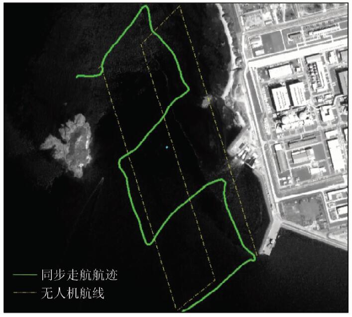
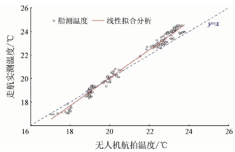
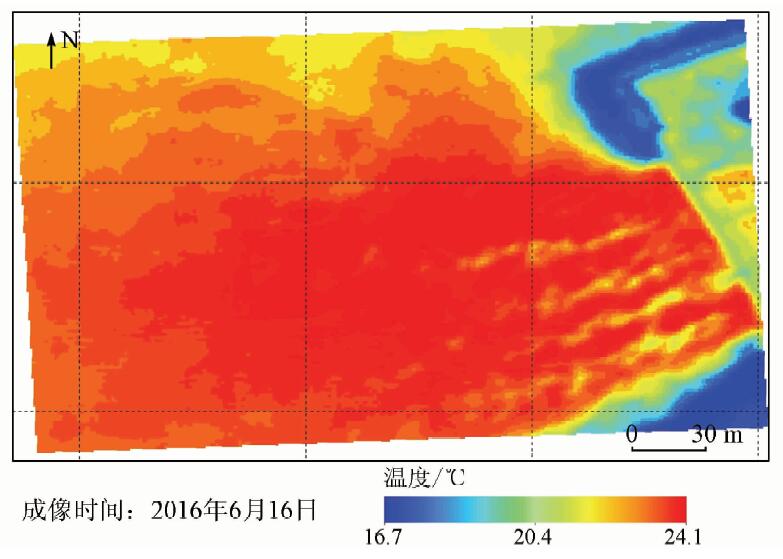
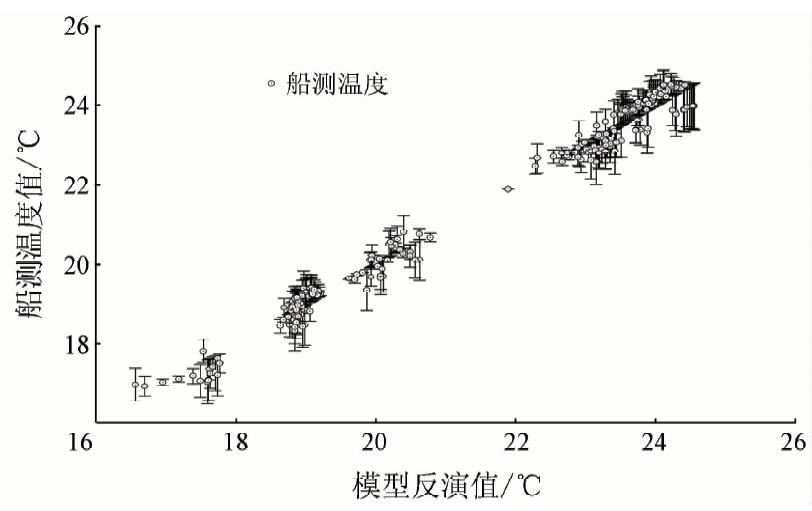
Existing monitoring approaches are not effective in dealing with routine thermal discharge monitoring requirements of nuclear power plants. This paper describes a monitoring methodology using an aerial remote sensing monitoring system based on an unmanned aerial vehicle (UAV) platform by taking the monitoring of the thermal discharge of the Hongyanhe Nuclear Power Plant, Liaoning Province as an example, and conducts a study of remote sensing extraction of thermal diffusion information of the thermal discharge. In this study, quartic polynomial fitting and real data correction are used to correct the wide-angle distortion and acquire the water body surface temperature information, respectively. Synchronized measured data validation of independent samples indicates that the system can acquire diffusion information of the thermal discharge accurately, and the retrieval error of the surface water temperature is within 0.4 °C. Results analysis shows that this efficient and convenient aerial remote sensing monitoring system based on a UAV platform can effectively make up inadequacies of existing monitoring technical measures and offers high precision. This system is expected to be further adopted and applied for post-assessment of the environmental impact of nuclear power plant thermal discharge and service monitoring.

Key wordsunmanned aerial vehicle (UAV) platform    aerial remote sensing    thermal discharge    wide-angle imaging distortion
收稿日期: 2017-04-11      出版日期: 2018-12-07
:  X57X87  
基金资助:高分辨率对地观测系统重大专项“高分海域使用动态监测与污染监测研究”(41-Y30B12-9001-14/16);海洋公益性行业科研专项“国家海洋局海域无人机监视监测关键技术研究与应用示范”共同资助(201405028)
通讯作者: 苏岫
作者简介: 王祥(1984-),男,助理研究员,博士,主要从事航空/航天遥感海洋信息获取及应用研究。Email: xwang@nmemc.org.cn
引用本文:   
王祥, 王新新, 苏岫, 孟庆辉, 邹德君, 伊晓东, 王林, 文世勇, 赵建华. 无人机平台航空遥感监测核电站温排水——以辽宁省红沿河核电站为例[J]. 国土资源遥感, 2018, 30(4): 182-186.
Xiang WANG, Xinxin WANG, Xiu SU, Qinghui MENG, Dejun ZOU, Xiaodong YI, Lin WANG, Shiyong WEN, Jianhua ZHAO. Thermal discharge monitoring of nuclear power plant with aerial remote sensing technology using a UAV platform: Take Hongyanhe Nuclear Power Plant,Liaoning Province,as example. Remote Sensing for Land & Resources, 2018, 30(4): 182-186.
链接本文:  
https://www.gtzyyg.com/CN/10.6046/gtzyyg.2018.04.27      或      https://www.gtzyyg.com/CN/Y2018/V30/I4/182
Fig.1  无人机航拍及同步走航航迹
Fig.2  “桶形畸变”影像
Fig.3  同心圆修正模型
Fig.4  同心圆模型修正桶形畸变
样点编号 拟合结果偏差
一次回归拟合 四次多项式拟合
1 -0.017 0
2 -0.022 -0.001
3 -0.019 0
4 -0.017 0
5 -0.011 0.001
6 -0.008 -0.003
7 -0.012 -0.003
8 -0.008 0.001
9 -0.013 -0.003
Tab.1  影像畸变校正结果比对
Fig.5  无人机航拍影像的温度标定
Fig.6  热扩散专题图
Fig.7  无人机航拍数据精度验证
[1] 朱利, 赵利民, 王桥 , 等. 核电站温排水分布卫星遥感监测及验证[J]. 光谱学与光谱分析, 2014,34(11):3079-3084.
Zhu L, Zhao L M, Wang Q , et al. Monitoring the thermal plume from nuclear power plant using satellite remote sensing data:Modeling and validation[J]. Spectroscopy and Spectral Analysis, 2014,34(11):3079-3084.
[2] 许静, 朱利, 姜建 , 等. 基于HJ-1B与TM热红外数据的大亚湾核电基地温排水遥感监测[J]. 中国环境科学, 2014,34(5):1181-1186.
doi: 10.3969/j.issn.1000-6923.2014.05.019
Xu J, Zhu L, Jiang J , et al. Monitoring thermal discharge in Daya Bay plant based on thermal infrared band of HJ-1B and TM remote sensing data[J]. China Environmental Science, 2014,34(5):1181-1186.
[3] 周颖, 巩彩兰, 匡定波 , 等. 基于环境减灾卫星热红外波段数据研究核电厂温排水分布[J]. 红外与毫米波学报, 2012,31(6):544-549.
Zhou Y, Gong C L, Kuang D B , et al. Distribution of thermal discharge from a power plant:Analysis of thermal infrared data from the environmental mitigation satellite[J]. Journal of infrared and millimeter waves, 2012,31(6):544-549.
[4] 许静 . 基于HJ-1B红外相机监测宁德核电温排水研究[D].北京:中国地质大学(北京), 2014.
Xu J . The Study on Monitoring Thermal Discharge of Ningde Nuclear Power Plant with HJ-1B Infarred Camera Data[D].Beijing:Beijing University of Geoscience(Beijing), 2014.
[5] 王祥, 苏岫, 王新新 , 等. 基于Landsat-8卫星数据的红沿河核电站温排水监测[J]. 红外, 2015,36(8):22-27.
Wang X, Su X, Wang X X , et al. Thermal plume monitoring of Hongyanhe nuclear power plant based on Landsat-8 satellite data[J]. Infrared, 2015,36(8):22-27.
[6] 张永红, 陈翰阅, 陈宜金 , 等. 基于Landsat-8/TIRS的红沿河核电基地海表温度反演算法比对[J]. 航天返回与遥感, 2015,36(5):96-104.
doi: 10.3969/j.issn.1009-8518.2015.05.012
Zhang Y H, Chen H Y, Chen Y J , et al. Comparative study on sea surface temperature retrieval methods of Hongyanhe nuclear power plant based on Landsat-8/TIRS[J]. Spacecraft recovery and remote sensing, 2015,36(5):96-104.
[7] 贺佳惠, 梁春利, 李明松 . 核电站近岸温度场航空热红外遥感测量数据处理研究[J]. 国土资源遥感, 2010,22(3):51-53.doi: 10.6046/gtzyyg.2010.03.11.
He J H, Liang C L, Li M S . Temperature field airborne thermal remote sensing survey of the alongshore nuclear power station[J]. Remote sensing for land and resources, 2010,22(3):51-53.doi: 10.6046/gtzyyg.2010.03.11.
[8] 孙恋君, 王凤英, 朱晓翔 . 田湾核电站温排水环境影响遥感调查[J]. 中国辐射卫生, 2011,20(3):330-332.
Sun L J, Wang F Y, Zhu X X . Remote sensing survey on environmental effects of thermal plume caused by Tianwan nuclear power station[J]. Chinese Journal of Radiological Health, 2011,20(3):330-332.
[9] Donlon C J, Minnett P J, Gentemann C , et al. Toward improved validation of satellite sea surface skin temperature measurements for climate research[J]. Journal of Climate, 2002,15(4):353-369.
doi: 10.1175/1520-0442(2002)015<0353:TIVOSS>2.0.CO;2
[10] Katsaros K B . The aqueous thermal boundary layer[J]. Boundary-Layer Meteorology, 1980,18(1):107-127.
doi: 10.1007/BF00117914
[1] 陈洁, 高子弘, 王珊珊, 金鼎坚. 三峡库区航空遥感地质调查技术发展综述[J]. 国土资源遥感, 2020, 32(2): 1-10.
[2] 石海岗, 梁春利, 张建永, 张春雷, 程旭. 岸线变迁对田湾核电站温排水影响遥感调查[J]. 国土资源遥感, 2020, 32(2): 196-203.
[3] 金鼎坚, 王建超, 吴芳, 高子弘, 韩亚超, 李奇. 航空遥感技术及其在地质调查中的应用[J]. 国土资源遥感, 2019, 31(4): 1-10.
[4] 陈凯, 房成法, 李儒. 航空遥感灾害应急区域协同优化研究[J]. 国土资源遥感, 2018, 30(3): 55-59.
[5] 魏永明, 魏显虎, 陈玉. 岷江流域映秀—茂县段地震次生地质灾害分布规律及发展趋势分析[J]. 国土资源遥感, 2014, 26(4): 179-186.
[6] 罗元华, 张志峰, 李志忠, 杨日红.  三峡工程库底清理中的遥感动态监测[J]. 国土资源遥感, 2005, 17(2): 69-71.
[7] 戴芹, 马建文, 陈雪, 刘建明, 王尔和. 航空遥感数据的贝叶斯网络分类[J]. 国土资源遥感, 2005, 17(1): 34-36.
[8] 卓宝熙. 风沙地区遥感图像分析及其对选线的意义[J]. 国土资源遥感, 2003, 15(4): 1-5.
[9] 王治华, 杨日红, 王毅. 秭归沙镇溪镇千将坪滑坡航空遥感调查[J]. 国土资源遥感, 2003, 15(3): 5-9,53.
[10] 本刊. 中国国土资源航空物探遥感中心简介[J]. 国土资源遥感, 2002, 14(1): 70-70.
[11] 高芳琴, 吴健平, 孙建中. 基于航空遥感数据的绿地信息提取与制图系统[J]. 国土资源遥感, 2001, 13(2): 57-61.
[12] 牛宝茹, 马贺平, 伍跃中, 吴军虎, 赵顺阳. 航空遥感技术在新疆和硕—库尔勒段高速公路工程地质调查中的应用[J]. 国土资源遥感, 1999, 11(4): 26-28.
[13] 张义彬, 曲家惠. 世界遥感技术发展现状及其地质应用[J]. 国土资源遥感, 1998, 10(4): 67-75.
[14] 龚卫红, 王毅敏. 彩红外遥感在果树资源调查中的应用[J]. 国土资源遥感, 1998, 10(4): 20-23.
[15] 李志中, 赵长英. 川藏公路中段地质灾害现象的航空遥感研究[J]. 国土资源遥感, 1998, 10(3): 14-18.
Viewed
Full text


Abstract

Cited

  Shared   
  Discussed   
京ICP备05055290号-2
版权所有 © 2015 《自然资源遥感》编辑部
地址:北京学院路31号中国国土资源航空物探遥感中心 邮编:100083
电话:010-62060291/62060292 E-mail:zrzyyg@163.com
本系统由北京玛格泰克科技发展有限公司设计开发