Please wait a minute...
 
国土资源遥感  2018, Vol. 30 Issue (4): 206-211    DOI: 10.6046/gtzyyg.2018.04.31
     本期目录 | 过刊浏览 | 高级检索 |
典型目标地面光谱信息系统设计与实现
张东辉, 赵英俊, 秦凯
核工业北京地质研究院遥感信息与图像分析技术国家级重点实验室,北京 100029
Design and construction of the typical ground target spectral information system
Donghui ZHANG, Yingjun ZHAO, Kai QIN
National Key Laboratory of Remote Sensing Information and Imagery Analyzing Technology, Beijing Research Institute of Uranium Geology, Beijing 100029, China
全文: PDF(3376 KB)   HTML  
输出: BibTeX | EndNote (RIS)      
摘要 

针对现有地物波谱库数据采集传感器单一、地物种类划分泛化性弱以及缺乏有效集成最新光谱分析模型等问题,提出构建典型目标地面光谱信息系统,对地面光谱数据获取、分析、处理和综合信息提取等技术进行科学设计和集成,并基于客户端层和服务器层(C/S)结构设计实现系统的信息表达。以岩矿和土壤重金属提取为例开展了示范研究。研究表明,系统达到了高效、快速和准确挖掘光谱蕴含的丰富地物信息的研究目标,为地物识别、资源勘查和生态环境评价等工作提供了技术支撑。

服务
把本文推荐给朋友
加入引用管理器
E-mail Alert
RSS
作者相关文章
张东辉
赵英俊
秦凯
关键词 典型目标地物光谱信息系统高光谱遥感    
Abstract

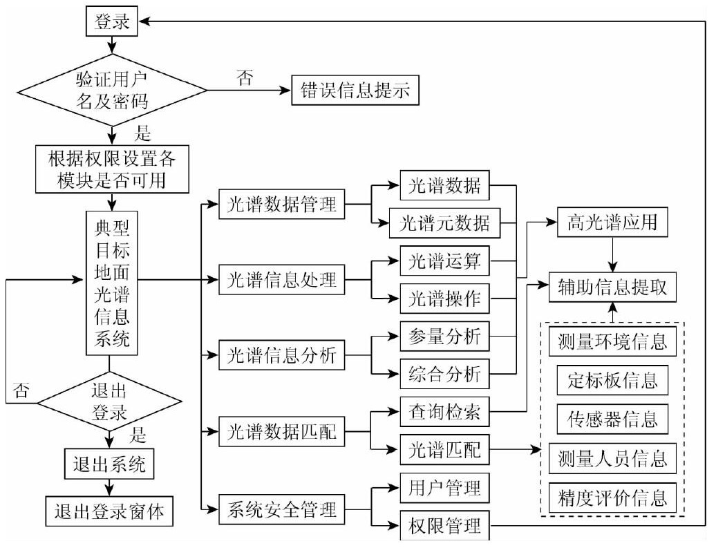
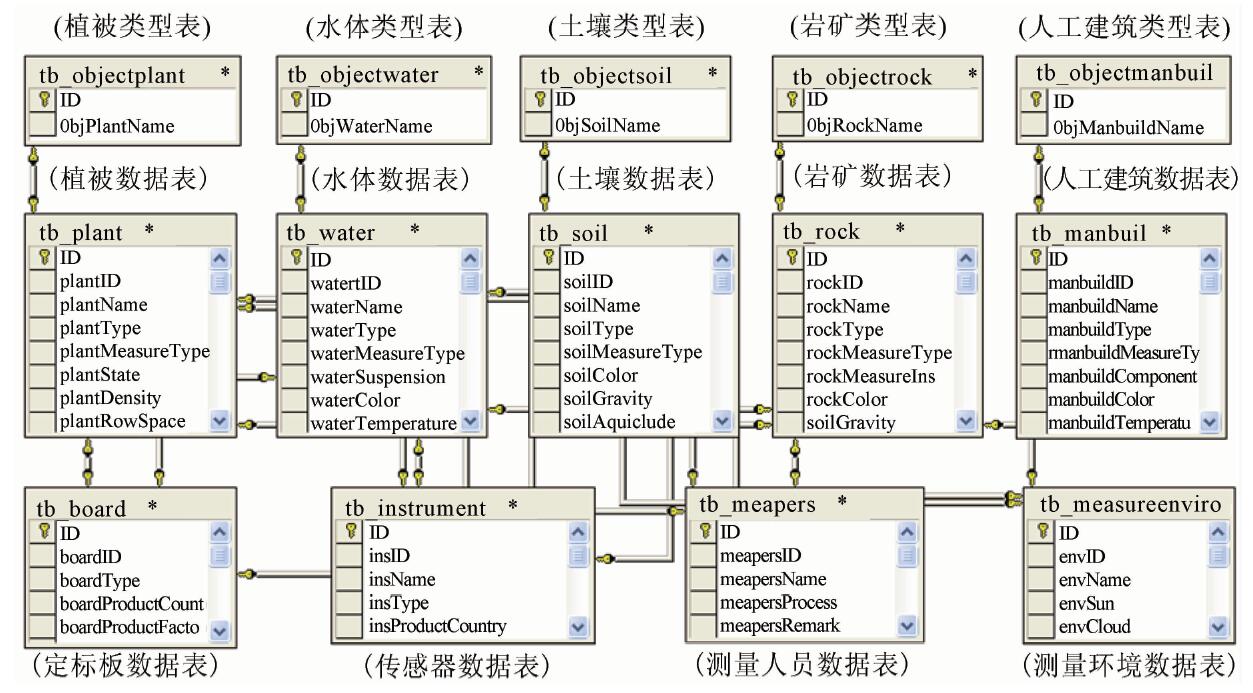
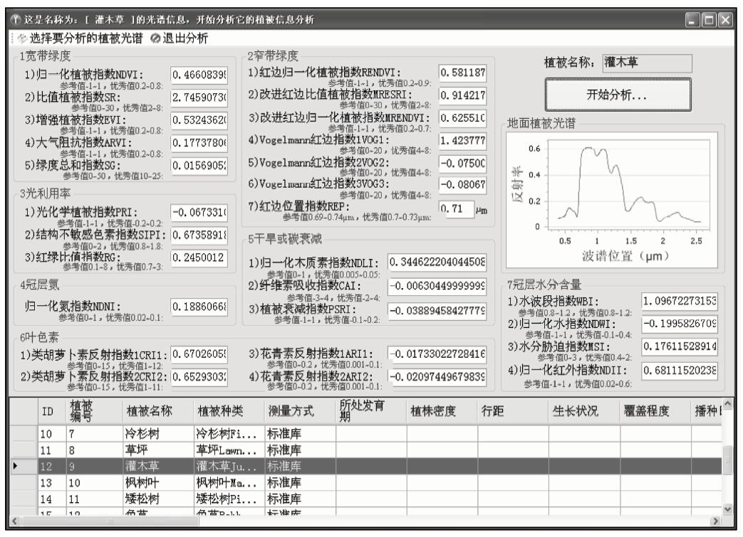
The spectral data in existing object spectrum library have some disadvantages, such as single data acquisition sensor; unreasonable ground objects classification and no efficient integration of the latest spectral analysis models. In order to solve these problems, this paper proposes a typical target ground spectral information system. The ground spectral data acquisition, analysis, processing and integrated information extraction are designed and integrated, and the information expression of the system is constructed based on the client layer and the server layer (C/S) structure. Taking the extraction of rocks, mines, and heavy metals from soils as an example, the authors conducted a demonstration study. The research shows that the system has achieved the goal of efficient, fast and accurate excavation of the rich ground information contained in the spectra, thus providing technical support for land identification, resource exploration and ecological environment evaluation.

Key wordstypical object    object spectral    information system    hyperspectral remote sensing
收稿日期: 2017-06-01      出版日期: 2018-12-07
:  P208  
基金资助:国家自然科学基金项目“高光谱矿物岩石集成学习研究”(41602333);“十三五”装备预先研究专项技术项目“周界安全综合探测技术研究”(32101080302);遥感信息与图像分析技术国家级重点实验室重点基金项目“典型地面光谱数据库构建研究”(9140C720105140C72001);中国地质调查局项目“机载高光谱调查”共同资助(12120113073000)
作者简介: 张东辉(1985-),男,博士,高级工程师,主要从事高光谱遥感技术与应用研究。Email: donghui222@163.com
引用本文:   
张东辉, 赵英俊, 秦凯. 典型目标地面光谱信息系统设计与实现[J]. 国土资源遥感, 2018, 30(4): 206-211.
Donghui ZHANG, Yingjun ZHAO, Kai QIN. Design and construction of the typical ground target spectral information system. Remote Sensing for Land & Resources, 2018, 30(4): 206-211.
链接本文:  
https://www.gtzyyg.com/CN/10.6046/gtzyyg.2018.04.31      或      https://www.gtzyyg.com/CN/Y2018/V30/I4/206
Fig.1  典型目标地面光谱信息系统结构
Fig.2  典型目标地面光谱信息系统数据表结构与表间关系
Fig.3  植被光谱综合分析系统提取光谱参数
Fig.4  系统支持下的土壤光谱处理结果
[1] 卞小林, 邵芸, 张风丽 , 等. 典型地物微波特性知识库的设计与实现[J]. 国土资源遥感, 2015,27(4):189-194.doi: 10.6046/gtzyyg.2015.04.29.
doi: 10.6046/gtzyyg.2015.04.29
Bian X L, Shao Y, Zhang F L , et al. Construction of the library of targets microwave properties[J]. Remote Sensing for Land and Resources, 2015,27(4):189-194.doi: 10.6046/gtzyyg.2015.04.29.
[2] 张妍, 薄立群, 路兴昌 . 长春净月潭地物波谱数据库的研究与开发[J]. 遥感信息, 2002,17(2):25-27.
doi: 10.3969/j.issn.1000-3177.2002.02.006
Zhang Y, Bo L Q, Lu X C . Design and development of object spectrum database in Jingyuetan of Changchun[J]. Remote Sensing Information, 2002,17(2):25-27.
[3] 田振坤, 刘素红, 傅莺莺 . 我国典型地物标准波谱数据库数据管理子系统设计与开发[J]. 计算机工程与应用, 2005,41(1):210-213.
doi: 10.3321/j.issn:1002-8331.2005.01.064
Tian Z K, Liu S H, Fu Y Y . Design and realization of spectral data management in the standard spectral knowledge base[J]. Computer Engineering and Applications, 2005,41(1):210-213.
[4] 方静, 刘文清, 李素文 . 基于Web的痕量气体特征光谱数据库[J]. 计算机工程, 2008,34(5):260-262.
Fang J, Liu W Q, Li S W . Web-based chararcteristic spectral data-base of trace gas[J]. Computer Engineering, 2008,34(5):260-262.
[5] 万余庆, 张凤丽, 闫永忠 . 矿物岩石高光谱数据库分析[J]. 地球信息科学, 2001,3(3):54-58.
doi: 10.3969/j.issn.1560-8999.2001.03.015
Wan Y Q, Zhang F L, Yan Y Z . The analysis of mineral and rock’s hyper-spectral library[J]. Geo-information science, 2001,3(3):54-58.
[6] 李新双 . 光谱数据库的设计及光谱匹配技术研究[D]. 武汉:武汉大学, 2005.
Li X S . Design of Spectral Database and Research on Spectral Matching Technology[D]. Wuhan:Wuhan University, 2005.
[7] 田庆久, 王世新, 王乐意 , 等. 典型地物标准波谱数据库系统设计[J]. 遥感技术与应用, 2003,18(4):185-190.
doi: 10.3969/j.issn.1004-0323.2003.04.001
Tian Q J, Wang S X, Wang L Y , et al. Remote sensing standardized spectral database system design[J]. Remote Sensing Technology and Application, 2003,18(4):185-190.
[8] 范俊甫 . 兖州矿区典型地物波谱数据库建设与应用研究[D]. 泰安:山东科技大学, 2011.
Fan J F . Study on Construction and Implementation of Typical Ground Object Spectrum Database in Fuzhou Mining Area[D]. Taian:Shandong University of Science and Technology, 2011.
[9] 李少鹏 . 新疆典型荒漠植物光谱数据库系统设计与实现[D]. 乌鲁木齐:新疆农业大学, 2013.
Li S P . The Design and Development of Xinjiang Typical Desert Plants Spectral Database System[D]. Urumqi:Xinjiang Agricultural University, 2013.
[10] 李少鹏, 李霞, 黄祥志 , 等. 新疆典型荒漠植物光谱数据库构建[J]. 新疆农业科学, 2013,50(6):1128-1136.
Li S P, Li X, Huang X Z , et al. Spectrum database construction of typical desert plants in Xinjiang[J]. Xinjiang Agricultural Sciences, 2013,50(6):1128-1136.
[1] 王茜, 任广利. 高光谱遥感异常信息在阿尔金索拉克地区铜金矿找矿工作中的应用[J]. 自然资源遥感, 2022, 34(1): 277-285.
[2] 高文龙, 张圣微, 林汐, 雒萌, 任照怡. 煤矿开采中SOM的遥感估算和时空动态分析[J]. 自然资源遥感, 2021, 33(4): 235-242.
[3] 姜亚楠, 张欣, 张春雷, 仲诚诚, 赵俊芳. 基于多尺度LBP特征融合的遥感图像分类[J]. 自然资源遥感, 2021, 33(3): 36-44.
[4] 臧传凯, 沈芳, 杨正东. 基于无人机高光谱遥感的河湖水环境探测[J]. 自然资源遥感, 2021, 33(3): 45-53.
[5] 赵龙贤, 代晶晶, 赵元艺, 姜琪, 刘婷玥, 傅明海. 基于RS和GIS技术的西藏多龙矿集区矿山选址研究[J]. 国土资源遥感, 2021, 33(2): 182-191.
[6] 苗苗, 谢小平. 基于GIS和RS的山东日照海岸带1988—2018年间演化分析[J]. 国土资源遥感, 2021, 33(2): 237-247.
[7] 胡新宇, 许章华, 陈文慧, 陈秋霞, 王琳, 刘辉, 刘智才. 基于PROBA/CHRIS影像的归一化阴影植被指数NSVI构建与应用效果[J]. 国土资源遥感, 2021, 33(2): 55-65.
[8] 孙珂. 融合超像元与峰值密度特征的遥感影像分类[J]. 国土资源遥感, 2020, 32(4): 41-45.
[9] 王瑞军, 张春雷, 孙永彬, 王诜, 董双发, 王永军, 闫柏琨. 高光谱在甘肃红山多金属找矿模型构建中的应用[J]. 国土资源遥感, 2020, 32(3): 222-231.
[10] 陈炫炽, 陈蓉, 吴愈锋, 王跃跃. 基于RS和GIS的都匀茶树种植地质背景调查[J]. 国土资源遥感, 2020, 32(1): 224-231.
[11] 李亚平, 卢小平, 张航, 路泽忠, 王舜瑶. 基于GIS和RUSLE的淮河流域土壤侵蚀研究——以信阳市商城县为例[J]. 国土资源遥感, 2019, 31(4): 243-249.
[12] 任广利, 杨敏, 李健强, 高婷, 梁楠, 易欢, 杨军录. 高光谱蚀变信息在金矿找矿预测中的应用研究——以北山方山口金矿线索为例[J]. 国土资源遥感, 2017, 29(3): 182-190.
[13] 苏红军, 刘浩. 一种利用空间和光谱信息的高光谱遥感多分类器动态集成算法[J]. 国土资源遥感, 2017, 29(2): 15-21.
[14] 张川, 叶发旺, 徐清俊, 刘洪成, 孟树. 新疆白杨河铀铍矿区航空高光谱矿物填图及蚀变特征分析[J]. 国土资源遥感, 2017, 29(2): 160-166.
[15] 林娜, 杨武年, 王斌. 基于核方法的高光谱遥感图像混合像元分解[J]. 国土资源遥感, 2017, 29(1): 14-20.
Viewed
Full text


Abstract

Cited

  Shared   
  Discussed   
京ICP备05055290号-2
版权所有 © 2015 《自然资源遥感》编辑部
地址:北京学院路31号中国国土资源航空物探遥感中心 邮编:100083
电话:010-62060291/62060292 E-mail:zrzyyg@163.com
本系统由北京玛格泰克科技发展有限公司设计开发