Retrieval of concentration of total suspended matter from GF-1 satellite and field measured spectral data during flood period in Poyang Lake
Chen GAO, Jian XU(), Dan GAO, Lili WANG, Yeqiao WANG
School of Geography and Environment Science & Ministry of Education’s Key Laboratory of Poyang Lake Wetland and Watershed Research, Jiangxi Normal University, Nanchang 330022, China
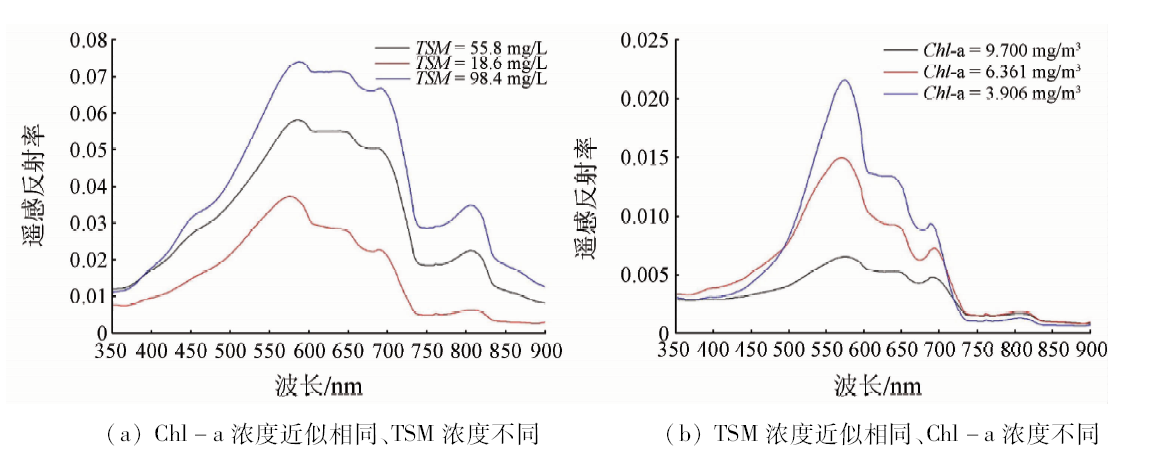
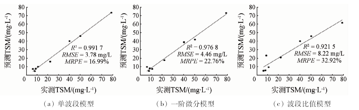
Total suspended matter is one of the important parameters to evaluate water quality. In this study, 33 data samples containing reflectance of water surface, concentration of total suspended matter and chlorophyll-a were used to conduct retrieval of total suspended matter, establish retrieval model and verify accuracy of model based on comparative analysis between field measured spectral reflectance and total suspended matter in Poyang Lake during the flood season. These models were single band, first-order differential and band ratio, respectively. The results showed that the R2 of three models was greater than 0.9, and the best was the single band model, and R2, RMSE and MRPE were 0.9805, 3.78mg/L and 16.99%, respectively. The single band model gave the better performance when it was applied to GF-1 satellite image data on August 3, 2015 and was validated, with R2, RMSE and MRPE being 0.8477, 12.23mg/L and 35.22%, respectively. It was also shown that the overall level of suspended matter concentration was low and the average value was 23.26mg/L. The higher value of total suspended matter was concentrated in the northern channel area. The concentration values of suspended matter was distributed uniformly in other areas of Poyang Lake. This model was further applied to GF-1 satellite image data on October 24, 2015 and was validated using 21 data samples of total suspended matter concentration obtained on October 23 and October 24, 2015. The retrieval accuracy was close to the result of image on August 3, 2015. The results indicate that this model can be also applied to retrieving the total suspended matter concentration of other periods in Poyang Lake. By analysis of field measured spectral reflectance and application of remote sensing image data, this study can provide reference for the retrieval of total suspended matter and environment monitoring of Poyang Lake.
高晨, 徐健, 高丹, 王莉莉, 王野乔. 基于GF-1与实测光谱数据鄱阳湖丰水期总悬浮物浓度反演[J]. 国土资源遥感, 2019, 31(1): 101-109.
Chen GAO, Jian XU, Dan GAO, Lili WANG, Yeqiao WANG. Retrieval of concentration of total suspended matter from GF-1 satellite and field measured spectral data during flood period in Poyang Lake. Remote Sensing for Land & Resources, 2019, 31(1): 101-109.
Ma Y L, Ma Y Q . Protection and utilization of Poyang Lake Wetland[J].Territory and Natural Resources Study, 2003(4):66-67.
[2]
de Leeuw J, Shankman D, Wu G , et al. Strategic assessment of the magnitude and impacts of sand mining in Poyang Lake,China[J]. Regional Environmental Change, 2010,10(2):95-102.
doi: 10.1007/s10113-009-0096-6
Li H J, Chen X L, Lu J Z , et al. Numerical simulation of suspended sediment concentration in Lake Poyang during flood season considering dredging activities[J]. Journal of Lake Science, 2016,28(2):421-431.
Wang X Q, Wang Q M, Wu Q Y , et al. Estimating suspended sediment concentration in coastal waters of Minjiang River using remote sensing images[J]. Journal of Remote Sensing, 2003,7(1):54-57.
Wang X Y, Li W D, Yan X H , et al. Information extraction for suspended sediment in Lake Chaohu and its distribution based on Landsat TM/ETM+ data[J]. Journal of Lake Science, 2007,19(3):255-260.
Liu X L, Shen F, Zhu W J , et al. Quantitative retrieval for suspended sediment concentration by using MERIS satellite data in the Yangtze River Estuary[J]. Resources and Environment in the Yangtze Basin, 2009,18(11):1026-1031.
[7]
Yu Q, Tian Y Q, Chen R F , et al. Functional linear analysis of in situ hyperspectral data for assessing CDOM in rivers[J]. Photogrammetric Engineering and Remote Sensing, 2010,76(10):1147-1158.
doi: 10.14358/PERS.76.10.1147
Song Q J, Ma R H, Tang J W , et al. Models of estimated total suspend matter concentration base on hyper-spectrum in Lake Taihu,in autumn[J]. Journal of Lake Science, 2008,20(2):196-202.
Chen J H, Xu H Q . Modeling of the suspended solid concentration of the Jin River based on high-spectral resolution data[J]. Remote Sensing Technology and Application, 2008,23(6):653-657.
Sun D Y, Li Y M, Wang Q , et al. Study on remote sensing estimation of suspended matter concentrations based on in situ hyperspectral data in Lake Tai waters[J]. Journal of Infared and Millimeter Waves, 2009,28(2):124-128.
[11]
白照广 . 高分一号卫星的技术特点[J].中国航天, 2013(8):5-9.
Bai Z G . The technical features of GF-1 satellite[J].Erospace China, 2013(8):5-9.
[12]
刘茜 , David G. Rossiter.基于高光谱数据和MODIS影像的鄱阳湖悬浮泥沙浓度估算[J]. 遥感技术与应用, 2008,23(1):7-11.
Liu Q, David G . R.Estimation on suspended sedimentation concentration of Poyang Lake using MODIS and hyperspectral data[J]. Remote Sensing Technology and Application, 2008,23(1):7-11.
Wang Y J, Zhang P Q, Dong W J , et al. Experimental study on reflected spectrum and estimating amount of suspended sediment[J].Journal of Sediment Research, 2007(5):36-41.
Cheng Q, Liu B, Li T , et al. Research on remote sensing retrieval of suspended sediment concentration in Hangzhou Bay by GF-1 satellite[J]. Marine Environmental Science, 2015,34(4):558-563.
[15]
Li J, Chen X, Tian L , et al. Improved capabilities of the Chinese high-resolution remote sensing satellite GF-1 for monitoring suspended particulate matter (SPM) in inland waters:Radiometric and spatial considerations[J]. ISPRS Journal of Photogrammetry and Remote Sensing, 2015,106:145-156.
doi: 10.1016/j.isprsjprs.2015.05.009
Shi H, Shen W J, Li Y , et al. Characteristics of GF images and application in eco-environmental monitoring in Taihu Lake[J]. Journal of Nanjing Forestry University (Natural Sciences Edition), 2016,40(6):63-68.
Li S H, Hui C X . A study on the quantitative model of the suspended sediment concentration from the meteorological satellite imagery[J]. Journal of Remote Sensing, 2001,5(2):154-160.
Tang J W, Tian G L, Wang X Y , et al. The methods of water spectra measurement and analysis I:Above-water method[J]. Journal of Remote Sensing, 2004,8(1):37-44.
Tang Z M, He Z G, Han Y M , et al. The measurement on suspended sediment concentration[J]. Acta Scientiarum Natyralium Universitatis Sunyatseni, 2003,42(2):244-247.
Chen Y W, Chen K N, Hu Y H . Discussion on possible error for phytoplankton chlorophyll-a concentration analysis using hot-ethanol extraction method[J]. Journal of Lake Science, 2006,18(5):550-552.
Zeng Q, Zhao Y, Tian L Q , et al. Evaluation the atemospheric correction methods for water color remote sensing by using HJ-1A/1B CCD image-taking Poyang Lake in China as a case[J]. Spectroscopy and Spectral Analysis, 2013,33(5):1320-1326.
Zeng Q, Zhang H D, Chen X L , et al. Evaluation on the atmospheric correction methods for water color remote SENSING by using MERIS image:A case study on chlorophyll-a concentration of Lake Poyang[J]. Journal of Lake Science, 2016,28(6):1306-1315.
[25]
Rundquist D C, Han L, Schalles J F , et al. Remote measurement of algal chlorophyll in surface waters:The case for the first derivative of reflectance near 690 nm[J]. Photogrammetric Engineering and Remote Sensing, 1996,62(2):195-200.
doi: 10.1016/S0924-2716(96)90007-6
[26]
Song K, Li L, Wang Z , et al. Retrieval of total suspended matter (TSM) and chlorophyll-a (Chl-a) concentration from remote-sensing data for drinking water resources[J]. Environmental Monitoring and Assessment, 2012,184(3):1449-1470.
doi: 10.1007/s10661-011-2053-3
pmid: 21526431
Chen X L, Wu Z Y, Tian L Q , et al. Inversion model for dynamic monitoring of suspended sediment:A case study on Poyang Lake[J]. Research on Remote Sensing Monitoring, 2007,25(6):19-22.
Chen J, Zhou G H, Wen Z H , et al. Study on quantitative model for suspended sediment concentration in Taihu Lake[J]. Spectroscopy and Spectral Analysis, 2010,30(1):137-141.
[29]
Gao B C . NDWI:A normalized difference water index for remote sensing of vegetation liquid water from space[J].Remote Sensing of Environment, 1996(58):257-266.
Bi H Y, Wang S Y, Zeng J Y , et al. Comparison and analysis of several common water extraction methods based on TM image[J]. Remote Sensing Information, 2012,27(5):77-82.
Cui L J, Zhai Y F, Wu G F . Dredging being moved southward enlarges the impacted region in Poyang Lake:The evidences from multi-remote sensing images[J]. Acta Ecologica Sinica, 2013,33(11):3520-3525.
Jiang F, Qi S H, Liao F Q , et al. Hydrological and sediment effects from sand mining in Poyang Lake during 2001—2010[J]. Acta Geographica Sinica, 2015,70(5):837-845.
[33]
Binding C E, Bowers D G ,Mitchelson-Jacob E G.Estimating suspended sediment concentrations from ocean colour measurements in moderately turbid waters:The impact of variable particle scattering properties[J]. Remote Sensing of Environment, 2005,94(3):373-383.
doi: 10.1016/j.rse.2004.11.002
 2019, Vol. 31
  ), 高丹, 王莉莉, 王野乔