Please wait a minute...
 
国土资源遥感  2019, Vol. 31 Issue (1): 271-276    DOI: 10.6046/gtzyyg.2019.01.35
  地理信息系统 本期目录 | 过刊浏览 | 高级检索 |
基于消息调度机制的地质服务体系构建及应用实践
张学利1, 马娜1, 杨燕2, 宋敦江3(), 汪健平4, 刘国5, 赵永明1
1.有色金属华东地质勘查局,南京 210007
2.中国地质调查局发展研究中心,北京 100037
3.中国科学院科技战略咨询研究院,北京 100037
4.山东省海洋资源与环境研究院,烟台 264006
5.中国地质图书馆,北京 100083
Development and application of the geological processing service system based on message scheduling
Xueli ZHANG1, Na MA1, Yan YANG2, Dunjiang SONG3(), Jianping WANG4, Guo LIU5, Yongming ZHAO1
1.East China Mineral Exploration and Development Bureau, Nanjing 210007, China
2.Development Research Center of China Geological Survey, Beijing 100037, China
3.Institutes of Science and Development, CAS, Beijing 100037, China
4.Shandong Marine Resource and Environment Research Institute, Yantai 264006, China
5.National Geological Library of China, Beijing 100083, China
全文: PDF(3624 KB)   HTML  
输出: BibTeX | EndNote (RIS)      
摘要 

分析了当前地质数据处理共享服务的现状与问题,提出了一种基于消息调度机制的分布式地质服务体系,该架构是地质服务体系的新尝试,初步解决了地质数据处理服务共享中的复用性问题。在简要介绍消息调度机制的概念和应用模式的基础上,基于发布/订阅模式设计了地质数据处理服务共享应用架构,实现了地质数据处理算法库的封装、地质数据服务共享的发布、描述了地质数据处理消息的流程,并以流程化地质数据处理在线服务为示例,简述了流程的设计和执行。实践证明,该体系能够复用已有的地质数据处理应用软件,满足互联网应用系统的快速开发的需要,节省算法重新编码和服务生产,可以在地质数据处理服务中推广使用。

服务
把本文推荐给朋友
加入引用管理器
E-mail Alert
RSS
作者相关文章
张学利
马娜
杨燕
宋敦江
汪健平
刘国
赵永明
关键词 消息队列地质算法库服务服务复用    
Abstract

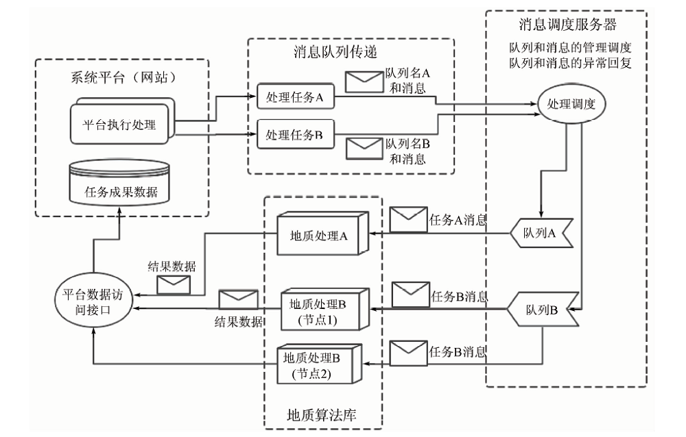
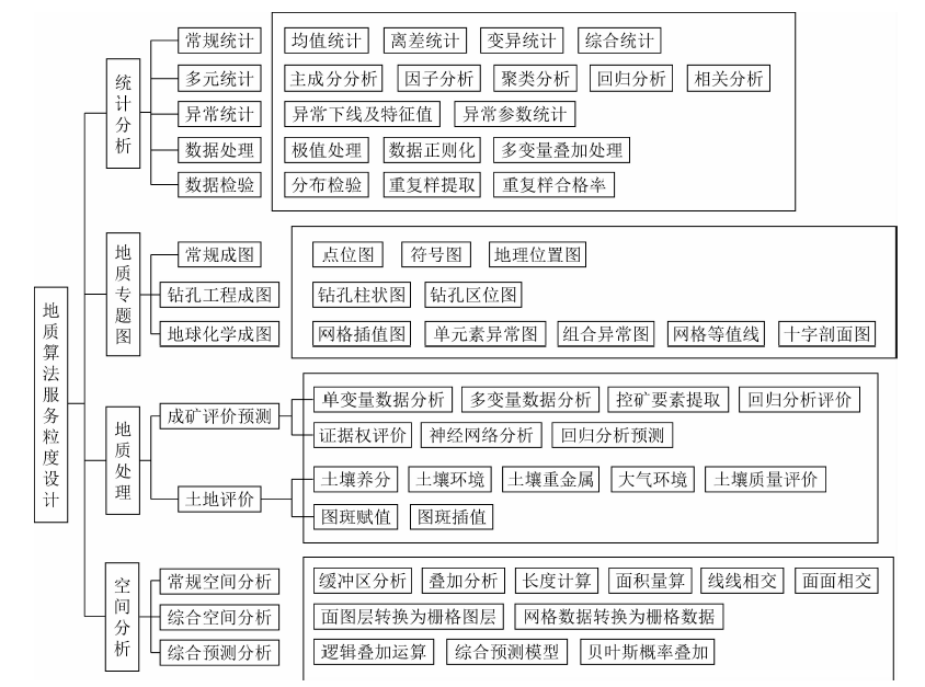
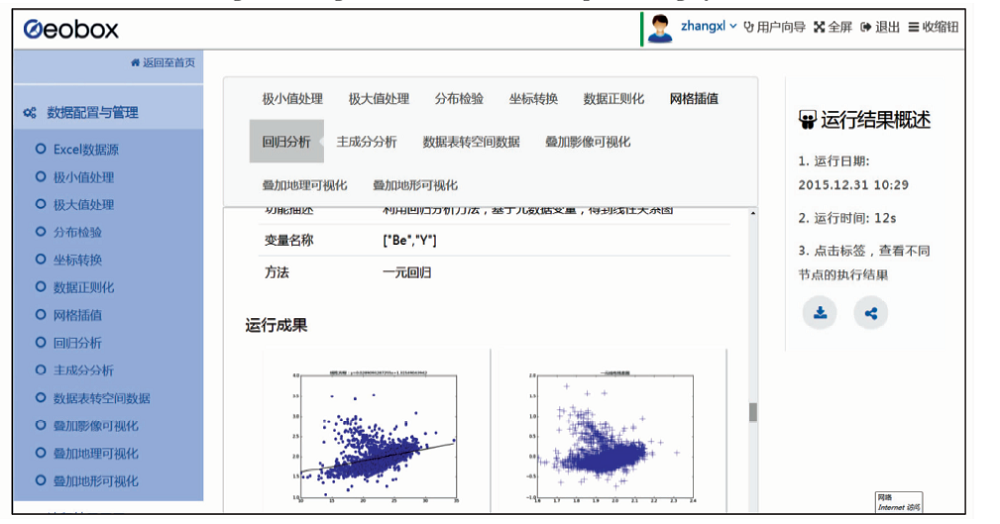
This paper analyzes the current situation and existing problems of geological data processing services,and proposes a distributed geological service system based on message scheduling mechanism. The architecture is a new attempt of the geological service system,and it preliminarily solves the reuse problem of geological data services and processing services. Firstly,the concept of message mechanism and application model is introduced; secondly, geological processing service application architecture of message scheduling mechanism is designed and the geological algorithm library service package as well as geological data sharing service is realized,and the geological message processing process is described. Lastly,an online processing services flow is demonstrated. Practice has proved that the scheduling mechanism can greatly reuse geological data services and processing services so as to meet the rapid development of Internet application system to save algorithm re-encoding and service production, so it can be widely used in geological data processing services.

Key wordsmessage queue    geological algorithm library    service reuse
收稿日期: 2017-11-09      出版日期: 2019-03-14
:  TP311  
基金资助:国家自然科学基金项目"空间插值的微分几何方法研究"和山东省2015年度农业重大应用技术创新课题"基于大数据的远洋渔业综合服务技术集成与示范"资助(41471338);山东省2015年度农业重大应用技术创新课题"基于大数据的远洋渔业综合服务技术集成与示范"
通讯作者: 宋敦江
作者简介: 张学利(1984-),男,硕士,工程师,主要从事地质云计算应用和WebGIS研发方面的研究。Email:273907398@qq.com。
引用本文:   
张学利, 马娜, 杨燕, 宋敦江, 汪健平, 刘国, 赵永明. 基于消息调度机制的地质服务体系构建及应用实践[J]. 国土资源遥感, 2019, 31(1): 271-276.
Xueli ZHANG, Na MA, Yan YANG, Dunjiang SONG, Jianping WANG, Guo LIU, Yongming ZHAO. Development and application of the geological processing service system based on message scheduling. Remote Sensing for Land & Resources, 2019, 31(1): 271-276.
链接本文:  
https://www.gtzyyg.com/CN/10.6046/gtzyyg.2019.01.35      或      https://www.gtzyyg.com/CN/Y2019/V31/I1/271
Fig.1  消息队列模式图
Fig.2  地质服务体系架构
名称 代号 类型
消息唯一认证码 Id 数值
用户编号 UserID 数值
地质处理服务类型 GeoServiceType 字符串
地质处理服务中文名称 ServiceName 字符串
地质处理服务英文名称 ServiceEnName 字符串
数据服务地址 DataAddress 字符串
地质处理服务参数 Param 数组
地质处理算法名称 AlgorithmName 字符串
地质处理算法标示码 AlgorithmID 数值
Tab.1  地质消息体参数
Fig.3  地质处理算法分类设计图
功能描述 开发工具
网站开发主平台 Play
业务数据库 PostGIS
内存数据库 Redis
消息调度服务器 RabbitMQ
负载均衡 Ngnix
地质云计算环境 Docker集群
WebGIS服务器 ArcGIS Server
Tab.2  平台开发工具列表
Fig.4  地质消息处理流程
Fig.5  流程化在线处理系统设计界面
Fig.6  流程在线处理结果界面
[1] Granell C, Díaz L, Gould M . Service-oriented applications for environmental models:Reusable geospatial services[J]. Environmental Modelling and Software, 2010,25(2):182-198.
doi: 10.1016/j.envsoft.2009.08.005
[2] Best B D, Halpin P N, Fujioka E , et al. Geospatial web services within a scientific workflow:Predicting marine mammal habitats in a dynamic environment[J]. Ecological Informatics, 2007,2(3):210-223.
doi: 10.1016/j.ecoinf.2007.07.007
[3] Feng M, Liu S G, Euliss Jr N H, et al. Prototyping an online wetland ecosystem services model using open model sharing standards[J]. Environmental Modelling and Software, 2011,26(4):458-468.
doi: 10.1016/j.envsoft.2010.10.008
[4] Fitch P, Bai Q F. A standards based web service interface for hydrological models[C]// Cairns.18th World IMACS/MODSIM Congress.Australia: 2009.
[5] 王卷乐, 游松财, 谢传节 , 等. 面向Web的地学数据共享服务平台架构设计[J]. 地球信息科学, 2004,6(4):62-65.
doi: 10.3969/j.issn.1560-8999.2004.04.014
Wang J L, You S C, Xie C J , et al. Study on web-oriented geo-data sharing platform system structure[J]. Geo-Information Science, 2004,6(4):62-45.
[6] 苏国辉, 申延平, 孙记红 , 等. 全球油气地质信息共享系统[J]. 地球信息科学, 2012,14(2):217-222.
doi: 10.3724/SP.J.1047.2012.00217
Su G H, Shen Y P, Sun J H , et al. The global oil and gas geology database information sharing system based on ArcGIS Serve[J]. Journal Of Geo-Information Science, 2012,14(2):217-222.
[7] 马维峰, 王晓蕊, 高山 . 基于关系数据库和WebGIS的中国东部地球化学科学数据库[J]. 地球科学-中国地质大学学报, 2008,33(3):423-430.
doi: 10.3321/j.issn:1000-2383.2008.03.019
Ma W F, Wang X R, Gao S . Geochemistry science database system for East China based on relational database and WebGIS[J]. Earth Science—Journal of China University of Geosciences, 2008,33(3):432-430.
[8] 高振记, 谢华锋, 李志伟 , 等. 油气资源地质调查大数据架构与应用研究[J]. 地理信息世界, 2016,23(1):18-23.
Gao Z J, Xie H F, Li Z W , et al. Research on the architecture and application of the big data in oil and gas geological survey[J]. Geomatics World, 2016,23(1):18-23.
[9] 缪谨励, 屈红刚, 许哲 , 等. 地学大数据技术研究实验平台GeoBDA[J]. 地理信息世界, 2014,21(6):48-52.
doi: 10.3969/j.issn.1672-1586.2014.06.009
Miao J L, Qu H G, Xu Z , et al. The experimental platform of technical study of the big data of geoscience:GeoBDA[J]. Geomatics World, 2014,21(6):48-52.
[10] 谭永杰 . 地质大数据体系建设的总体框架研究[J]. 中国地质调查, 2016,3(3):1-6.
TAN Y J . Architecture investigation of the construction of geological big data system[J]. Geological Survey of China, 2016,3(3):1-6.
[11] 姜作勤, 马智民, 杨东来 , 等. 地质信息服务体系框架研究[J]. 中国地质, 2007,34(1):173-178.
doi: 10.3969/j.issn.1000-3657.2007.01.025
Jiang Z Q, Ma Z M, Yang D L , et al. Framework of the geological information service system[J]. Geology in China, 2007,34(1):173-178.
[12] 刘荣梅, 严光生, 夏庆霖 . 从第34届国际地质大会看地学信息技术发展趋势[J]. 地质通报, 2013,32(4):685-692.
doi: 10.3969/j.issn.1671-2552.2013.04.016
Liu R M, Yan G S, Xia Q L . The progress and development trend of the geoscience information technology viewed from the abstracts submitted to the 34th IGC held in Brisbane,Australia[J]. Geological Bulletin of China, 2013,32(4):685-692.
[13] 胡磊, 乐鹏, 龚健雅 , 等. 异步地理信息网络处理服务方法研究[J]. 武汉大学学报(信息科学版), 2016,41(5):679-685.
doi: 10.13203/j.whugis20140413
Hu L, Le P, Gong J Y , et al. An approach to asynchronous geoprocessing service[J]. Geomatics and Information Science of Wuhan University, 2016,41(5):679-685.
[14] 刘熙, 胡志勇 . 基于Docker容器的Web集群设计与实现[J]. 电子设计工程, 2016,24(8):117-119.
doi: 10.3969/j.issn.1674-6236.2016.08.033
Liu X, Hu Z Y . Design and implementation of Web cluster based on Docker container[J]. Electronic Design Engineering, 2016,24(8):117-119.
[15] 刘思尧, 李强, 李斌 . 基于Docker技术的容器隔离性研究[J]. 软件, 2015,36(4):110-113.
doi: 10.3969/j.issn.1003-6970.2015.04.025
Liu S R, Li Q, Li B . Research on isolation of container based on Docker technology[J]. Software, 2015,36(4):110-113.
[1] 刁明光, 刘文静, 李静, 刘芳, 王彦佐. 矿山遥感监测矢量成果数据动态变化检测方法[J]. 国土资源遥感, 2020, 32(3): 240-246.
[2] 随欣欣, 眭素文. 基于MapGIS和ArcGIS的遥感解译成果图件数据库设计与实现[J]. 国土资源遥感, 2018, 30(4): 218-224.
[3] 熊文兵, 莫伟华, 丁美花, 王君华, 莫建飞. 基于开源GIS的生态质量气象评价系统[J]. 国土资源遥感, 2018, 30(2): 243-248.
[4] 任丽艳, 李英成, 薛艳丽, 丁晓波, 吴豪. 基于北斗技术的无人机飞行监管系统开发与应用[J]. 国土资源遥感, 2018, 30(2): 238-242.
[5] 倪金生, 刘翔, 杨劲林, 潘健, 苏晓玉. 多源动态异构空间标绘内容整合研究[J]. 国土资源遥感, 2017, 29(1): 208-212.
[6] 吴新强, 周娅, 王如意, 张会兵, 秦兴国. MapGIS地学数据和符号库的ArcGIS转换方案[J]. 国土资源遥感, 2015, 27(4): 183-188.
[7] 郝明, 张建龙, 牛瑞卿, 梁虹. 地质调查信息网格结点建设——以西南地区为例[J]. 国土资源遥感, 2015, 27(4): 195-199.
[8] 孙记红, 苏国辉, 杨辰, 何书锋. 面向业务的海洋地质数据服务平台构建方法[J]. 国土资源遥感, 2015, 27(2): 190-195.
[9] 周伟, 黄炜, 王彦佐, 李敬敏, 刘若溪. 资源一号02C卫星数据管理与服务系统研建[J]. 国土资源遥感, 2014, 26(1): 179-185.
[10] 贾春阳, 李卫华, 李小春. 基于自适应权值FNEA算法的高分辨率遥感图像分割[J]. 国土资源遥感, 2013, 25(4): 22-25.
[11] 张明洋, 马维峰, 唐湘丹, 李仙伟. 地质灾害三维遥感解译成果的自动制图方法[J]. 国土资源遥感, 2013, 25(2): 164-167.
[12] 秦学秀, 张保钢. 道路定线技术在北京市规划道路数据管理系统建设中的应用[J]. 国土资源遥感, 2013, 25(2): 180-184.
[13] 施益强, 吴丽娜, 吴陈锋. 基于GIS的雷达数据三维可视化与预警系统设计与实现[J]. 国土资源遥感, 2013, 25(1): 171-175.
[14] 王建超, 郭大海, 郑雄伟. 机载POS直接地理定位软件AeroDG的设计与实现[J]. 国土资源遥感, 2007, 19(4): 28-32.
Viewed
Full text


Abstract

Cited

  Shared   
  Discussed   
京ICP备05055290号-2
版权所有 © 2015 《自然资源遥感》编辑部
地址:北京学院路31号中国国土资源航空物探遥感中心 邮编:100083
电话:010-62060291/62060292 E-mail:zrzyyg@163.com
本系统由北京玛格泰克科技发展有限公司设计开发