1.Beijing Key Laboratory for Remote Sensing of Environment and Digital Cities, Faculty of Geographical Science, Beijing Normal University, Beijing 100875, China 2.Key Laboratory of Environmental Change and Natural Disaster of Ministry of Education, Faculty of Geographical Science, Beijing Normal University, Beijing 100875, China 3.State Key Laboratory of Earth Surface Processes and Resource Ecology, Faculty of Geographical Science, Beijing Normal University, Beijing 100875, China 4.Chinese Research Academy of Environmental Sciences, Beijing 100012, China
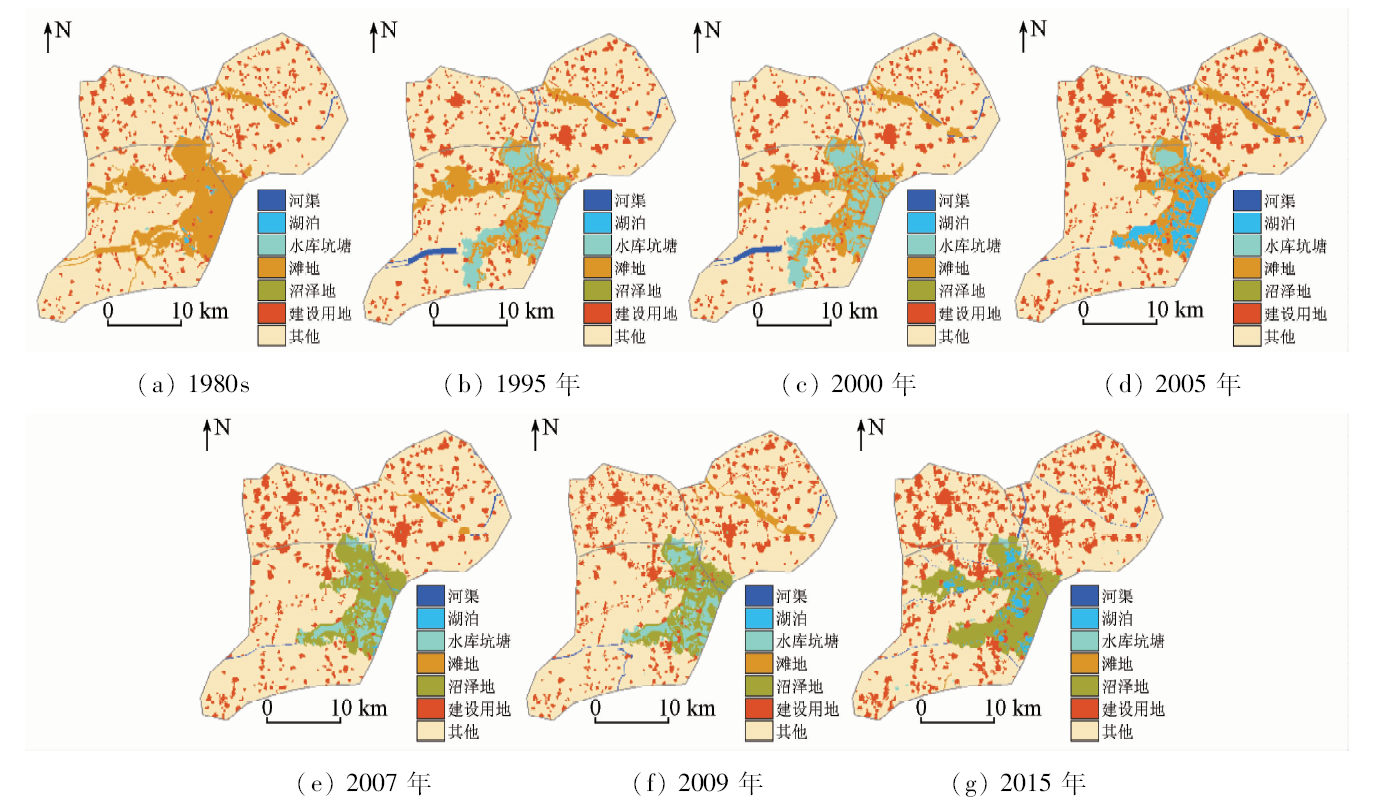
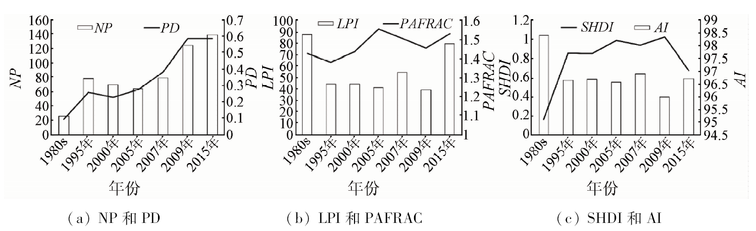
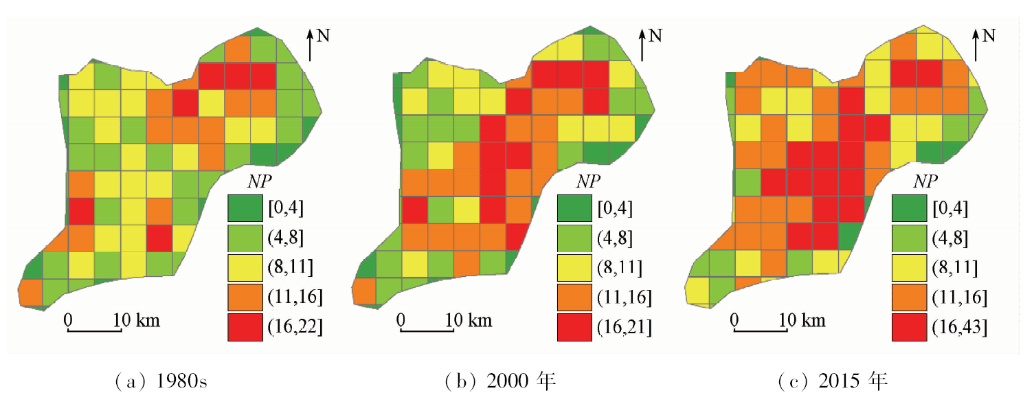
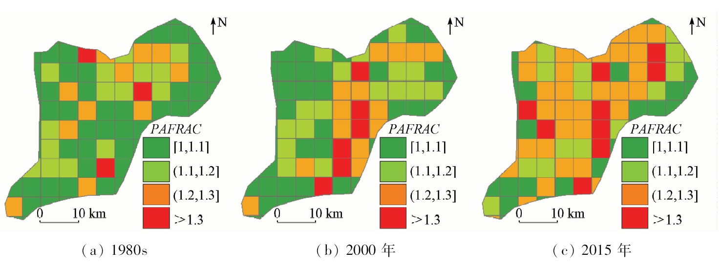
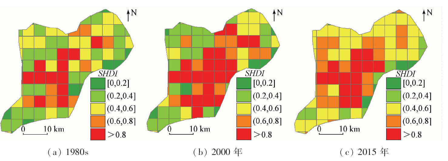
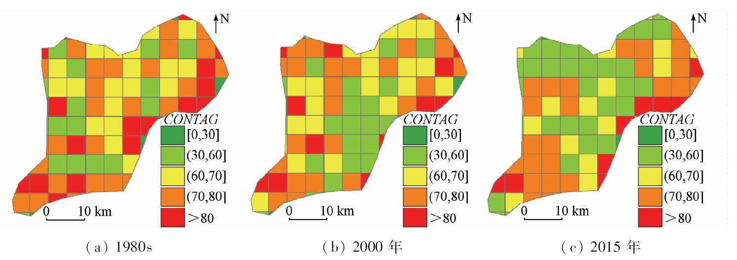
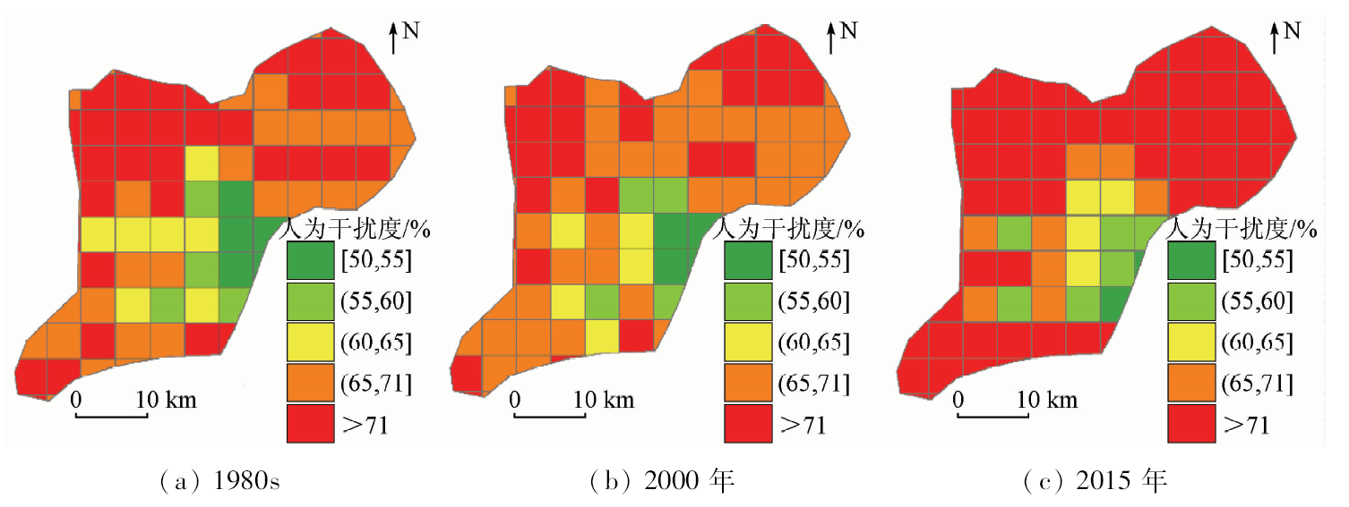
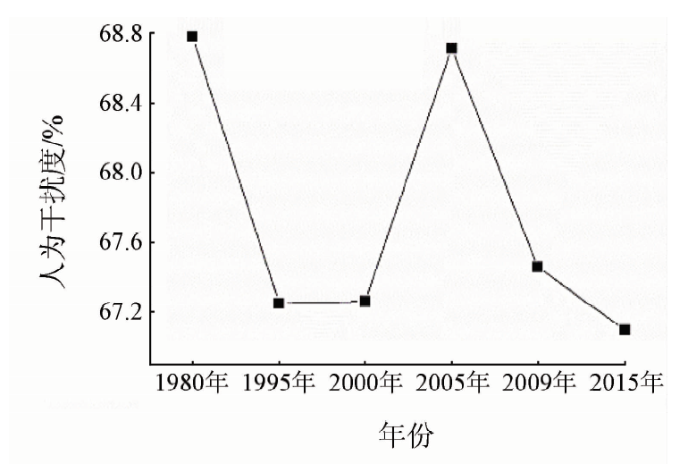
Wetland, one of the most important ecosystems on Earth, is well known as belonging to three major ecosystems together with forest and ocean. In recent years, wetland ecosystems have been threatened by the impact of human activities and urban development. It is of great significance to carry out the study of the relationship between wetland landscape evolution and human disturbance and to protect the ecological environment of wetland in Xiong’an New Area. In this paper, the authors analyzed the wetland landscape evolution and the response to human disturbance in Xiong’an New Area based on the moving window landscape method by using the land use data from the late 1980s to 2015. Some conclusions have been reached: From the 1980s to 2015, wetland landscape changed in Xiong’an New Area. From the time series, the wetland area showed a decrease trend mainly and wetland fragmentation increased gradually. The patch shape became complicated and the degree of connection was reduced. From the spatial distribution pattern, after the year of 2000, the wetlands fragmentation gradually increased in the central and northeastern area, and the fragmentation from the core area of the central wetlands to the edge gradually increased. From the 1980s to 2015, human disturbances showed a decreased trend mainly. The human disturbance decreased in the central and southwestern area from the 1980s to 2000. From 2000 to 2015, the human disturbance increased and then slowed down, which indicated that the wetland had shifted to the low intensity and sustainable development under the implementation of wetland protection policies. The human disturbance of the surrounding areas was affected by the expansion of construction land. The human disturbance has a good correspondence with wetland distribution.
吕金霞, 蒋卫国, 王文杰, 刘颖慧, 邓越, 王晓雅. 基于移动窗口法雄安新区湿地景观演变及其与人为干扰间的关系[J]. 国土资源遥感, 2019, 31(2): 140-148.
Jinxia LYU, Weiguo JIANG, Wenjie WANG, Yinghui LIU, Yue DENG, Xiaoya WANG. Wetland landscape evolution and its relation to human disturbance in Xiong’an New Area based on the moving window method. Remote Sensing for Land & Resources, 2019, 31(2): 140-148.
Du P J, Chen Y, Tan K . Monitoring and analyzing wetland landscape pattern change and ecological security using remote sensing images:A case study of Jiangsu coastal wetland[J]. Remote Sensing for Land and Resources, 2014,26(1):158-166.doi: 10.6046/gtzyyg.2014.01.27.
[2]
Jiang W G, Lyu J X, Wang C C , et al. Marsh wetland degradation risk assessment and change analysis:A case study in the Zoige Plateau,China[J]. Ecological Indicators, 2017,82:316-326.
doi: 10.1016/j.ecolind.2017.06.059
Miao L L, Jiang W G, Wang S D , et al. Comprehensive assessments and zoning of ecological service functions for Beijing wetland based on RS and GIS[J]. Remote Sensing for Land and Resources, 2013,25(3):102-108.doi: 10.6046/gtzyyg.2013.03.18.
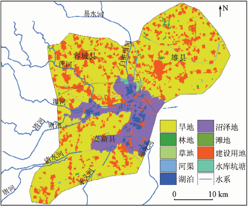
Li J G, Li G B, Cui H M , et al. Degradation of reed wetland and protection in Baiyangdian[J]. South-to-North Water Transfers and Water Science and Technology, 2004,2(3):35-38.
Zhang M, Gong Z N, Zhao W J . Analysis of driving forces of Baiyangdian wetland evolution during 1984—2013[J]. Chinese Journal of Ecology, 2016,35(2):499-507.
Bai J H, Fang J S, Huang L B , et al. Landscape pattern evolution and its driving factors of Baiyangdian lake-marsh wetland system[J]. Geographical Research, 2013,32(9):1634-1644.
[8]
Abdullah S A, Nakagoshi N . Changes in landscape spatial pattern in the highly developing state of Selangor,peninsular Malaysia[J]. Landscape and Urban Planning, 2006,77(3):263-275.
doi: 10.1016/j.landurbplan.2005.03.003
Shi Y T, Wen H Y, Qiao G J . An analysis of impact of human activities on wetland ecological environment in Luanhe River estuary[J]. South-to-North Water Transfers and Water Science and Technology, 2011,9(3):124-128.
Chen A L, Zhu B Q, Chen L D , et al. Dynamic changes of landscape pattern and eco-disturbance degree in Shuangtai estuary wet land of Liaoning Province[J]. Chinese Journal of Applied Ecology, 2010,21(5):1120-1128.
Kuang W H, Yang T R, Yan F Q . Regional urban land-cover characteristics and ecological regulation during the construction of Xiong’an New District,Hebei Province,China[J]. Acta Geographica Sinica, 2017,72(6):947-959.
Jiang L G, Lyu P Y, Feng Z M , et al. Land use patterns of the Xiong’an New Area and comparison among potential choices of start zone[J]. Resources Science, 2017,39(6):991-998.
Zhou Y . Assessment of the Ecological Health of Wetlands in Baiyangdian Nature Reserve by RS and GIS Techniques[D]. Baoding:Hebei University, 2017.
[14]
Liu J Y, Kuang W H, Zhang Z X , et al. Spatiotemporal characteristics,patterns,and causes of land-use changes in China since the late 1980s[J]. Journal of Geographical Sciences, 2014,24(2):195-210.
doi: 10.1007/s11442-014-1082-6
[15]
Ning J, Liu J Y, Kuang W H , et al. Spatiotemporal patterns and characteristics of land-use change in China during 2010—2015[J]. Journal of Geographical Sciences, 2018,28(5):547-562.
doi: 10.1007/s11442-018-1490-0
[16]
陆健健 . 中国滨海湿地的分类[J].环境导报, 1996 (1):1-2.
Lu J J . Classification of coastal wetlands of China[J].Environment Herald, 1996 (1):1-2.
[17]
McDonnell M J, Pickett S T A . Ecosystem structure and function along urban-rural gradients:An unexploited opportunity for ecology[J]. Ecology, 1990,71(4):1232-1237.
doi: 10.2307/1938259
Liu Q, Liu S L, Zhao Q H , et al. Gradient analysis of landscape pattern affected by hydroelectric station based on moving window method[J]. Journal of Mountain Science, 2012,30(5):638-646.
Liu J P, Dong C Y, Sheng L X , et al. Landscape pattern change of the marsh and its response to human disturbance in the Small Sanjiang Plain,1955—2010[J]. Scientia Geographica Sinica, 2016,36(6):879-887.
Sun Y G, Zhao D Z, Wu T , et al. Temporal and spatial dynamic changes and landscape pattern response of Hemeroby in Dayang estuary of Liaoning Province,China[J]. Acta Ecologica Sinica, 2012,32(12):3645-3655.
Xiao C, Xie X F, Wu T , et al. Dynamic changes of landscape pattern and hemeroby in Ximen Island wetland,Zhejiang Province,China[J]. Chinese Journal of Applied Ecology, 2014,25(11):3255-3262.
 2019, Vol. 31