1.College of Geomatics, Xi’an University of Science and Technology, Xi’an 710054, China; 2.School of Geology and Environment, Xi’an University of Science and Technology, Xi’an 710054, China;
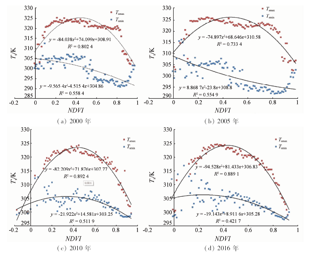
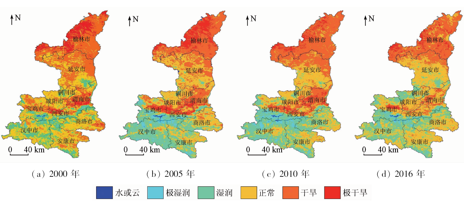
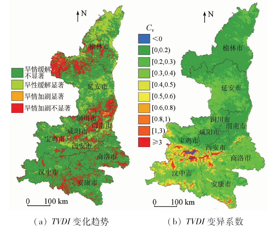
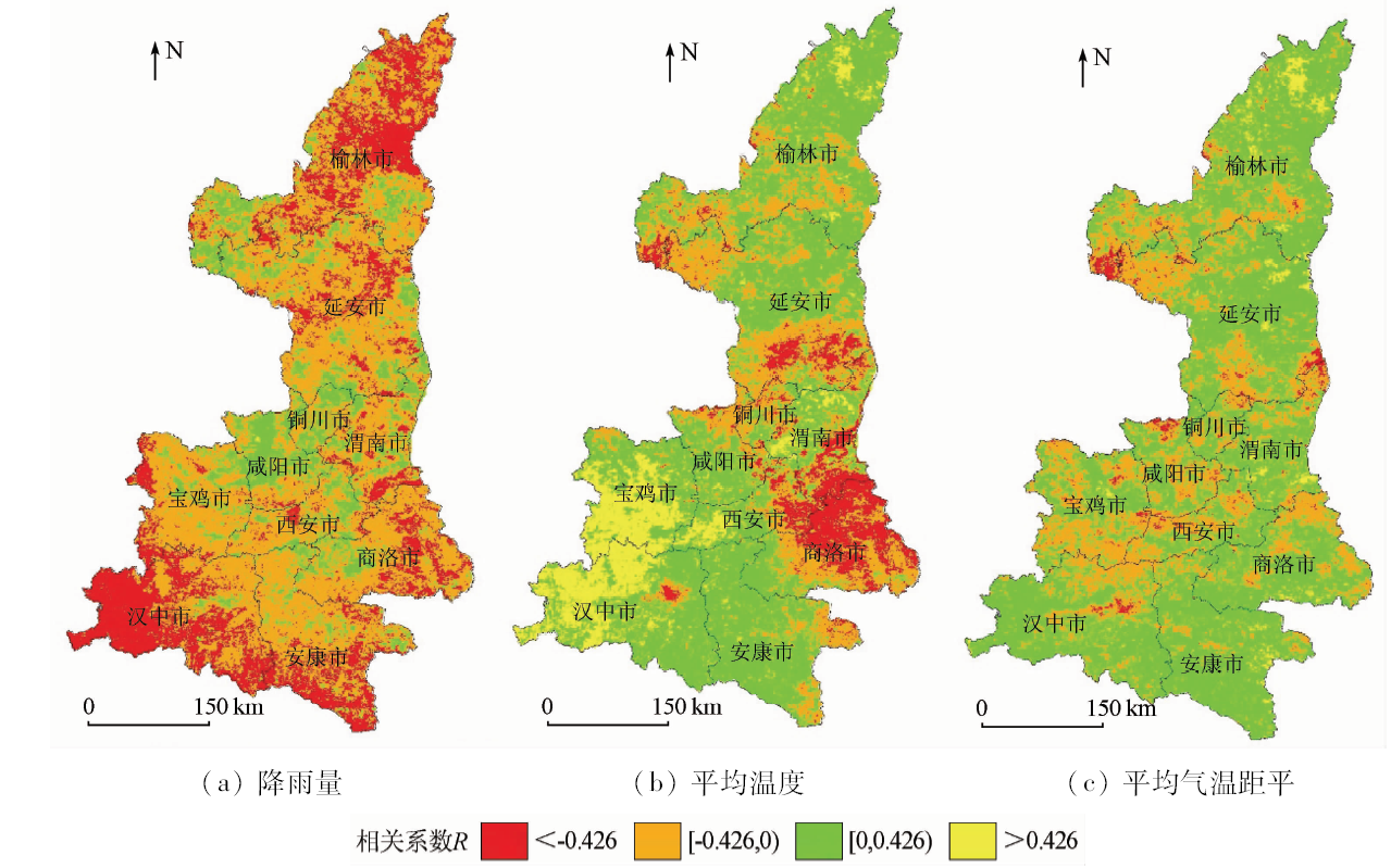
Based on MODIS normalized difference vegetation index (NDVI) and land surface temperature (Ts) data, the authors constructed a bi-parabolic NDVI-Ts space which was verified by the filed measured soil moisture, and monitored the spatial and temporal distribution characteristics of drought conditions in Shaanxi Province from 2000 to 2016 based on the TVDI obtained from bi-parabolic NDVI-Ts space. The results show that the NDVI-Ts space was bi-parabolic and there was a significant negative correlation (P<0.05) between TVDI and 10 cm depth filed measured soil moisture. Spatially, the drought in Shaanxi Province during 2000—2016 were mainly distributed in the northwest, north of Shaanxi and the northeastern regions of Guanzhong plain; the drought area of Shaanxi Province accounted for 31.95% in 2000 and 27.65% in 2016, respectively. It is found that drought was significantly relieved in most northern part of Yulin City, the middle part of Yan’an City and the central part of Guanzhong Plain and some parts of southern Shaanxi, which accounted for 14.45 %. The drought conditions in 84.48 % of the province were changed, but the change failed to pass the significant test. 97.62% of the province had a small variation coefficient, which was between 0 and 0.8. It was mainly distributed in northern Shaanxi, south of Guanzhong Plain, and it showed that the drought conditions were stable in Shaanxi Province. There was a significant negative correlation between drought and annual precipitation, accounting for 23.74 % (P<0.1). With the increase of rainfall, TVDI decreased, and the drought was relieved. It was mainly distributed in most areas of Yulin City, central parts of Yan’an City, north and northwest of Hanzhong City, Ankang City, northern parts of Weinan City, eastern parts of Shangluo City and western and northern parts of Baoji City. It is found that the changes of drought in other areas were not significantly affected by precipitation. The annual temperature was not dominant factors that resulted in the change of drought in Shaanxi Province.
刘英, 岳辉, 侯恩科. MODIS数据在陕西省干旱监测中的应用[J]. 国土资源遥感, 2019, 31(2): 172-179.
Ying LIU, Hui YUE, Enke HOU. Drought monitoring based on MODIS in Shaanxi. Remote Sensing for Land & Resources, 2019, 31(2): 172-179.
Liu L Y, Liao J S, Chen X Z , et al. The microwave temperature vegetation drought index (MTVDI) based on AMSR-E,brightness temperatures for long-term drought assessment across China(2003—2010)[J]. Remote Sensing of Environment, 2017,199(15):302-320.
doi: 10.1016/j.rse.2017.07.012
Zhang Q, Yao Y B, Li Y H , et al. Research progress and prospect on the monitoring and early warning and mitigation technology of meteorological drought disaster in Northwest China[J]. Advances in Earth Science, 2015,30(2):196-213.
Wang L T, Wang S X, Zhou Y , et al. Advances and application analysis of drought monitoring using remote sensing[J]. Journal of Remote Sensing, 2011,15(6):1322-1330.
[4]
Sandholt I, Rasmussen K, Andersen J . A simple interpretation of the surface temperature/vegetation index space for assessment of surface moisture status[J]. Remote Sensing of Environment, 2002,79(2):213-224.
doi: 10.1016/S0034-4257(01)00274-7
[5]
Wan Z, Wang P, Li X P . Using MODIS land surface temperature and normalized difference vegetation index products for monitoring drought in the southern Great Plains,USA[J]. International Journal of Remote Sensing, 2004,25(1):61-72.
doi: 10.1080/0143116031000115328
[6]
Bajgiran P R, Darvishsefat A A, Khalili A , et al. Using AVHRR-based vegetation indices for drought monitoring in the northwest of Iran[J]. Journal of Arid Environments, 2008,72(6):1086-1096.
doi: 10.1016/j.jaridenv.2007.12.004
[7]
Haroon M A, Zhang J H, Yao F M . Drought monitoring and performance evaluation of MODIS-based drought severity index (DSI) over Pakistan[J]. Natural Hazards, 2016,84(2):1349-1366.
doi: 10.1007/s11069-016-2490-y
[8]
Du L T, Song N P, Liu K , et al. Comparison of two simulation methods of the temperature vegetation dryness index (TVDI) for drought monitoring in semi-arid regions of China[J]. Remote Sensing, 2017,9(2):177.
doi: 10.3390/rs9020177
Yan N, Li D K, Du J W , et al. Monitoring of drought situation in Shaanxi Province based on MODIS land product LST,NDVI and EVI[J]. Journal of Natural Disaster, 2010,19(4):178-182.
Li J, Wang L X, Shen C , et al. Application and comparison of several drought monitoring models in Northern Shaanxi[J]. Chinese Journal of Agrometeorology, 2014,35(1):97-102.
Bai X J, Wang P X, Xie Y , et al. Spatial distribution characteristics of droughts in Guanzhong Plain based on structural similarity[J]. Transactions of the Chinese Society for Agricultural, 2015,46(11):345-351.
Quan W T, Zhou H, Li H M , et al. Multiple band drought index(MBDI)retrieve and comparison between FY-3C/MERSI and MODIS[J]. Arid Land Geography, 2016,39(4):835-842.
Liu Y, Ma B D, Wu L X , et al. Drought remote sensing for winter wheat based on double parabola NDVI-ST space[J]. Transactions of the Chinese Society for Agricultural Machinery, 2012,43(5):55-63.
[14]
Liu Y, Wu L X, Yue H . Biparabolic NDVI-Ts space and soil moisture remote sensing in an arid and semi-arid area[J]. Canadian Journal of Remote Sensing, 2015,41(3):159-169.
doi: 10.1080/07038992.2015.1065705
Liu Y, Hou E K, Yue H . Dynamic monitoring and trend analysis of vegetation change in Shendong mining area based on MODIS[J]. Remote Sensing for Land and Resources, 2017,29(2):132-137.doi: 10.6046/gtzyyg.2017.02.19.
[16]
Carlson T N, Gillies R R, Perry E M . A method to make use of thermal infrared temperature and NDVI measurements to infer surface soil water content and fractional vegetation cover[J]. Remote Sensing Review, 1994,9(1-2):161-173.
doi: 10.1080/02757259409532220
[17]
Moran M S, Clarke T R, Inoue Y , et al. Estimating crop water deficit using the relation between surface-air temperature and spectral vegetation index[J]. Remote Sensing of Environment, 1994,49(3):246-263.
doi: 10.1016/0034-4257(94)90020-5
Liu Y, Yue H, Zhang F , et al. Drought monitoring of winter wheat in Henan Province based on LAI-Ts space[J]. Chinese Journal of Agrometeorology, 2018,39(2):129-139.
[20]
Liu Y, Yue H . The temperature vegetation dryness index (TVDI) based on bi-parabolic NDVI-Ts space and gradient-based structural similarity (GSSIM) for long-term drought assessment across Shaanxi Province,China(2000—2016)[J]. Remote Sensing, 2018,10(6):959.
doi: 10.3390/rs10060959
 2019, Vol. 31