Please wait a minute...
 
国土资源遥感  2019, Vol. 31 Issue (3): 59-64    DOI: 10.6046/gtzyyg.2019.03.08
  技术方法 本期目录 | 过刊浏览 | 高级检索 |
空谱特征分层融合的高光谱图像特征提取
姚本佐1, 何芳2
1. 安徽公安职业学院,合肥 230088
2. 火箭军工程大学核工程学院,西安 710025
Spatial and spectral feature hierarchical fusion for hyperspectral image feature extraction
Benzuo YAO1, Fang HE2
1. Anhui Police College, Hefei 230088, China
2. School of Nuclear Engineering,Rocket Force Engineering University, Xi’an 710025, China;
全文: PDF(3769 KB)   HTML  
输出: BibTeX | EndNote (RIS)      
摘要 

利用基于光谱维的特征提取方法将原始高光谱图像数据降到一定维数,对降维后的数据采用多尺度自适应加权滤波器(adaptive weighted filters,AWF)进行滤波,将在所有尺度上得到的滤波结果分层融合为新的图像,设计了分层融合框架,有效提取出了高光谱图像中重要的空谱特征,从而提高了分类精度。又将主成分分析(principal component analysis,PCA)算法融入到该框架中,提出了分层融合-主成分分析(hierarchical fusion principal component analysis,HF-PCA)算法。该方法不仅降低了波段间的冗余性,而且削弱了样本的类内差异性,提高了高光谱图像的分类精度。在Indian Pines和Salinas数据库上的实验结果表明,即使在训练样本数量较少的情况下,由HF-PCA算法得到的分类精度明显高于其他算法,2种数据总体分类精度的最大值分别为86.73%和95.01%,有效提高了高光谱图像的分类精度。

服务
把本文推荐给朋友
加入引用管理器
E-mail Alert
RSS
作者相关文章
姚本佐
何芳
关键词 空谱特征分层融合分层融合-主成分分析高光谱图像分类    
Abstract

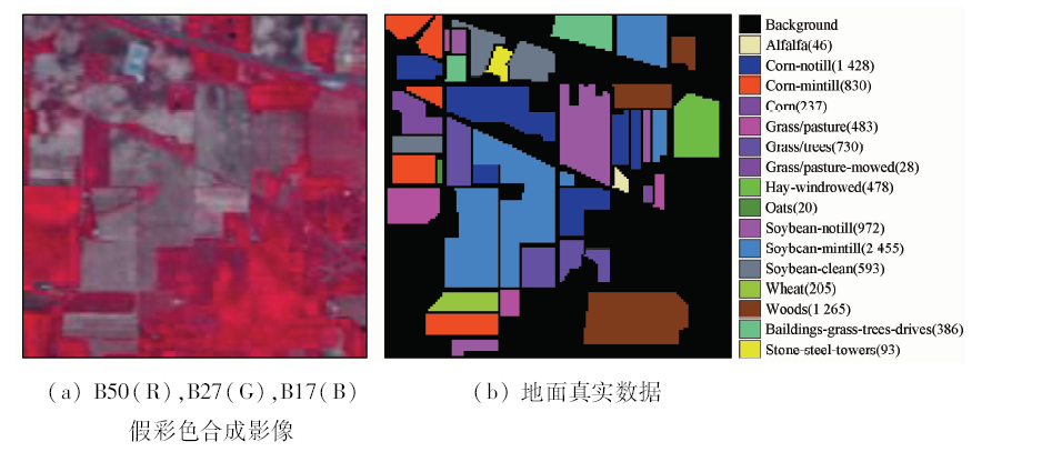
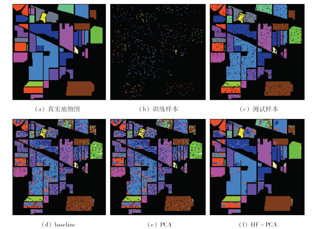
In this paper, the multi-dimensional adaptive weighted filter (AWF) is used to filter the hyperspectral image with a certain dimension which are reduced by the feature extraction method based on spectral dimension. Then, the filter results obtained on all scales are hierarchical fusion into a new image, and the hierarchical fusion framework is designed. These treatments make the essential spatial and spectral features in hyperspectral images extracted effectively, so the classification accuracy is improved. The principal component analysis (PCA) algorithm is integrated into the framework, and a hierarchical fusion-principal component analysis (HF-PCA) algorithm is proposed. This method not only reduces the redundancy between bands, but also weakens the internal differences of the samples and improves the classification accuracy of hyperspectral images. Experimental results on the Indian Pines and Salinas databases demonstrate that the classification accuracy obtained by the HF-PCA algorithm is significantly higher than that of other algorithms, even when the number of training samples is small, and the maximum value of the overall classification accuracy is 86.73% and 95.01%, respectively. The classification accuracy of hyperspectral images is improved effectively.

Key wordsspatial and spectral feature    hierarchical fusion    hierarchical fusion-principal component analysis    hyperspectral image classification
收稿日期: 2018-10-08      出版日期: 2019-08-30
:  TP751  
基金资助:质量工程项目安徽省教育厅警务实战技能教学团队资助
作者简介: 姚本佐(1964-),男,副教授,主要从事警务指挥与战术方向研究。Email: ybZ135@sina.com.。
引用本文:   
姚本佐, 何芳. 空谱特征分层融合的高光谱图像特征提取[J]. 国土资源遥感, 2019, 31(3): 59-64.
Benzuo YAO, Fang HE. Spatial and spectral feature hierarchical fusion for hyperspectral image feature extraction. Remote Sensing for Land & Resources, 2019, 31(3): 59-64.
链接本文:  
https://www.gtzyyg.com/CN/10.6046/gtzyyg.2019.03.08      或      https://www.gtzyyg.com/CN/Y2019/V31/I3/59
Fig.1  AWF示意图
Fig.2  单次HF-PCA算法框架
Fig.3  Indian Pines图像
Fig.4  Salinas图像
Fig.5  Indian Pines数据库各算法的分类结果
地物类别 KNN PCA HF-PCA 地物类别 KNN PCA HF-PCA
Alfalfa 80.56 80.56 97.78 Oats 80.00 70.00 100
Corn-notill 46.57 45.84 84.32 Soybeans-notill 61.21 60.46 87.06
Corn-mintill 57.49 56.60 79.06 Soybeans-mintill 66.21 64.71 90.21
Corn 28.00 29.33 47.20 Soybeans-clean 44.40 43.16 70.05
Grass/pasture 78.87 78.21 87.93 Wheat 94.36 93.33 98.15
Grass/trees 94.37 94.52 97.63 Woods 88.02 88.69 95.97
Grass/pasture-mowed 100 100 97.78 Buildings-grass-tree-drives 41.14 39.78 62.94
Hay-windrowed 94.71 94.05 98.37 Stone-steel-towers 85.54 85.54 92.53
Tab.1  Indian Pines数据库不同算法各类地物的分类精度
Fig.6  Salinas数据库各算法分类结果
地物类别 KNN PCA HF-PCA 地物类别 KNN PCA HF-PCA
Brocoli-green-weeds_1 98.54 98.54 99.75 Soil-vinyard-develop 97.49 97.39 99.56
Brocoli-green-weeds_2 98.54 98.43 99.70 Corn-senesced-green-weeds 83.94 83.20 92.49
Fallow 80.88 79.09 96.62 Lettuce-romained-4wk 88.93 88.93 89.76
Fallow-rough-plow 98.70 98.70 99.07 Lettuce-romained-5wk 100 100 99.97
Fallow-smooth 95.36 96.27 97.83 Lettuce-romained-6wk 97.57 96.91 99.05
Stubble 98.85 98.85 99.78 Lettuce-romained-7wk 87.54 87.44 96.83
Celery 98.93 98.93 99.60 Vinyard_untrained 59.65 59.32 88.25
Grapes-untrained 70.39 69.30 89.57 Vinyard_vertical-trellis 89.66 89.60 96.18
Tab.2  Salinas数据库不同算法各类地物的分类精度
[1] 高晓惠 . 高光谱数据处理技术研究[D]. 西安:中国科学院大学, 2013.
Gao X H . Research on Technologies of Hyperspectral Data Processing[D]. Xi’an:University of Chinese Academy of Science, 2013.
[2] Plaza A, Benediktsson J A, Boardman J W , et al. Recent advances in techniques for hyperspectral image processing[J]. Remote Sensing of Environment, 2009,113(s1):S110-S122.
[3] Bioucas-Dias J M, Plaza A, Camps-Valls G , et al. Hyperspectral remote sensing data analysis and future challenges[J]. IEEE Geoscience and Remote Sensing Magazine, 2013,1(2):6-36.
[4] 王晓飞, 侯传龙, 阎秋静 , 等. 基于相关向量机的高光谱图像噪声评估算法[J]. 红外与激光工程, 2014,43(12):4159-4163.
Wang X F, Hou C L, Yan Q J , et al. Noise estimation algorithm based on relevance vector machine for hyperspectral imagery[J]. Infrared and Laser Engineering, 2014,43(12):4159-4163.
[5] 张成业, 秦其明, 陈理 , 等. 高光谱遥感岩矿识别的研究进展[J]. 光学精密工程, 2015,23(8):2407-2418.
Zhang C Y, Qin Q M, Chen L , et al. Research and development of mineral identification utilizing hyperspectral remote sensing[J]. Optics and Precision Engineering, 2015,23(8):2407-2418.
[6] 邓承志, 张绍泉, 汪胜前 , 等. L1稀疏正则化的高光谱混合像元分解算法比较[J]. 红外与激光工程, 2015,44(3):1092-1097.
Deng C Z, Zhang S Q, Wang S Q , et al. Hyperspectral unmixing algorithm based on L1 regularization[J]. Infrared and Laser Engineering, 2015,44(3):1092-1097.
[7] 唐中奇, 付光远, 陈进 , 等. 基于多尺度分割的高光谱图像稀疏表示与分类[J]. 光学精密工程, 2015,23(9):2708-2714.
Tang Z Q, Fu G Y, Chen J , et al. Multiscale segmentation-based sparse coding for hyperspectral image classification[J]. Optics and Precision Engineering, 2015,23(9):2708-2714.
[8] 王琳, 李迅, 包云轩 , 等. 遥感技术在交通气象灾害监测中的应用进展[J]. 国土资源遥感, 2018,30(4):1-7.doi: 10.6046/gtzyyg.2018.04.01.
Wang L, Li X, Bao Y X , et al. Research progress of remote sensing application meteorological disasters[J]. Remote Sensing for Land and Resources, 2018,30(4):1-7.doi: 10.6046/gtzyyg.2018.04.01.
[9] 叶珍 . 高光谱图像特征提取与分类算法研究[D]. 西安:西北工业大学, 2015.
Ye Z . Research on Feature Extraction and Classification Algorithm for Hyperspectral Image[D]. Xi’an:Northwestern Polytechnical University, 2015.
[10] 黄鸿, 杨媚, 张满菊 . 基于稀疏鉴别嵌入的高光谱遥感影像分类[J]. 光学精密工程, 2013,21(11):2922-2930.
doi: 10.3788/OPE.20132111.2922
Huang H, Yang M, Zhang M J . Hyperspectral remote sensing image classification based on SDE[J]. Optics and Precision Engineering, 2013,21(11):2922-2930.
[11] 黄鸿, 郑新磊 . 加权空-谱与最近邻分类器相结合的高光谱图像分类[J]. 光学精密工程, 2016,24(4):873-881.
Huang H, Zheng X L . Hyperspectral image classification with combination of weighted spatial-spectral and KNN[J]. Optics and Precision Engineering, 2016,24(4):873-881.
[12] Li H, Wei Y, Li L , et al. Hierarchical feature extraction with local neural response for image recognition[J]. IEEE Transactions on Systems Man and Cybernetics Part B:Cybernetics, 2012,43(2):412-424.
[13] Pu H Y, Chen Z H, Wang B . A novel spatial-spectral similarity measure for dimensionality reduction and classification of hyperspectral imagery[J]. IEEE Transactions on Geoscience and Remote Sensing, 2014,52(11):7008-7022.
[14] 金鹏磊 . 空谱联合高光谱数据降维与分类方法研究[D]. 西安:西安电子科技大学, 2014.
Jin P L . Researches on Spatial-Spectral Based Dimensionality Reduction and Classification of Hyperspectral Data[D]. Xi’an:Xidian University, 2014.
[1] 韩彦岭, 崔鹏霞, 杨树瑚, 刘业锟, 王静, 张云. 基于残差网络特征融合的高光谱图像分类[J]. 国土资源遥感, 2021, 33(2): 11-19.
[2] 阿茹罕, 何芳, 王标标. 加权空-谱主成分分析的高光谱图像分类[J]. 国土资源遥感, 2019, 31(2): 17-23.
[3] 刘万军, 李天慧, 曲海成. 基于Fisher准则和TrAdaboost的高光谱相似样本分类算法[J]. 国土资源遥感, 2018, 30(4): 41-48.
Viewed
Full text


Abstract

Cited

  Shared   
  Discussed   
京ICP备05055290号-2
版权所有 © 2015 《自然资源遥感》编辑部
地址:北京学院路31号中国国土资源航空物探遥感中心 邮编:100083
电话:010-62060291/62060292 E-mail:zrzyyg@163.com
本系统由北京玛格泰克科技发展有限公司设计开发