A high resolution remote sensing image segmentation method based on superpixel and graph theory
Bingxiu YAO1, Liang HUANG1,2(), Yansong XU1
1. Faculty of Land Resource Engineering, Kunming University of Science and Technology, Kunming 650093,China 2. Surveying and Mapping Geo-Informatics Technology Research Center on Plateau Mountains of Yunnan Higher Education, Kunming 650093, China
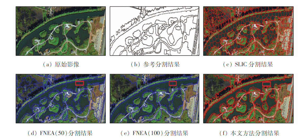
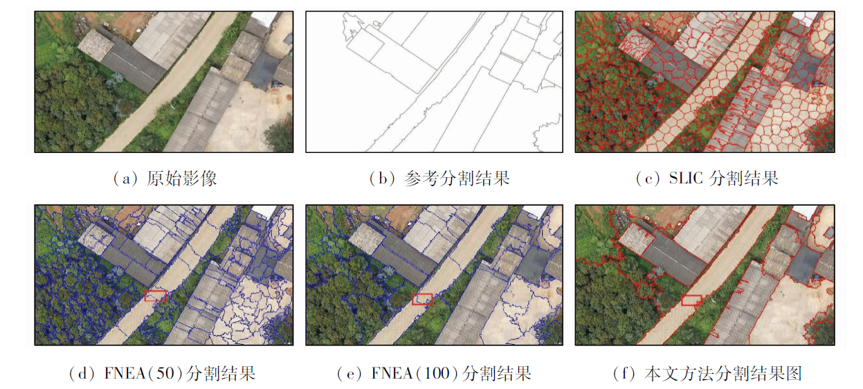
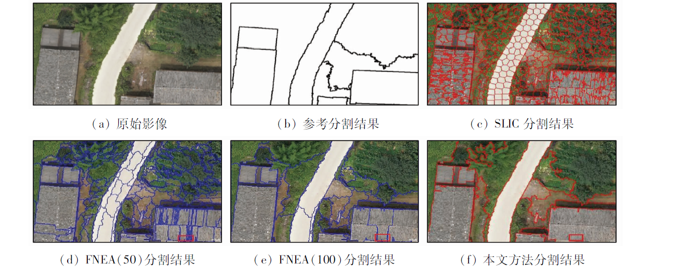
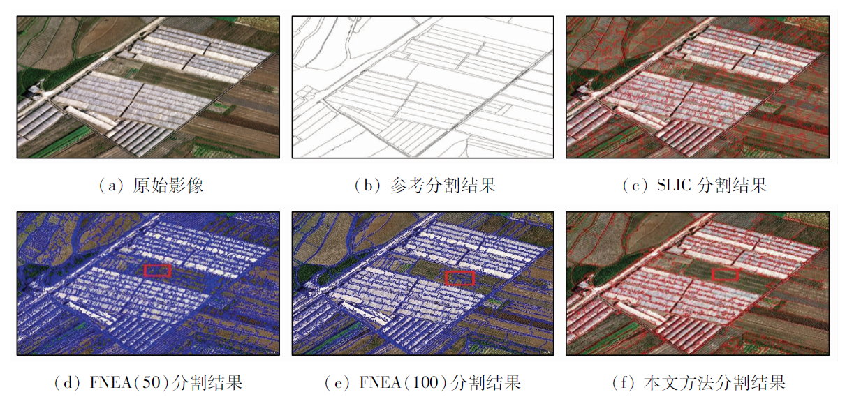
Superpixel segmentation has become a new hotspot in remote sensing image preprocessing, but it has the problem of over segmentation. To solve this problem, the authors propose a high resolution remote sensing image segmentation method combining superpixel and graph theory. First, the simple linear iterative clustering (SLIC) algorithm is used to divide the image into superpixels, then the superpixels are merged by the graph theory algorithm, the local variance corresponding to the combined number of the merged numbers are calculated, and the appropriate image segmentation number is determined. Finally, according to the appropriate image segmentation number, the graph theory algorithm is used to recluster and merge the superpixels. Four groups of remote sensing images of different scenes and different spatial resolutions were selected as experimental data. The qualitative and quantitative analysis of experimental results was evaluated. Experimental results show that the proposed method can effectively overcome the effect of over segmentation results and achieve good segmentation results.
Liu J, Li P J . A high resolution image segmentation method by combined structural and spectral characteristics[J]. Acta Geodaetica Et Cartographica Sinica, 2014,43(5):466-473.
Su T F, Li H Y, Qu Z Y . A study of road segmentation from the high resolution remote sensing image[J]. Remote Sensing for Land and Resources, 2015,27(3):1-6.doi: 10.6046/gtzyyg.2015.03.01.
[3]
Szekely G J, Rizzo M L . Hierarchical clustering via joint between-within distances:Extending ward’s minimum variance method[J]. Journal of Classification, 2005,22(2):151-183.
[4]
Johnson S C . Hierarchical clustering schemes[J]. Psychometrika, 1967,32(3):241-254.
[5]
Ren X, Malik J . Learning a classification model for segmentation [C]//Proceedings 9th IEEE International Conference on Computer Vision.IEEE, 2003,1:10-17.
[6]
Shi J B, Malik J . Normalized cuts and image segmentation[J]. IEEE Transactions on Pattern Analysis and Machine Intelligence, 2000,22(8):888-905.
[7]
Felzenszwalb P F, Huttenlocher D P . Efficient graph-based image segmentation[J]. International Journal of Computer Vision, 2004,59(2):167-181.
[8]
Bergh M V D, Boix X, Roig G , et al. Seeds:Superpixels extracted via energy-driven sampling[J]. International Journal of Computer Vision, 2015,111(3):298-314.
[9]
Moore A P, Prince S J D, PWarrell J, et al. Superpixel lattices [C]//2008 IEEE Conference on Computer Vision and Pattern Recognition.IEEE, 2008: 1-8.
[10]
Wang Y, Ye Y, Shi X . Multi-focus image fusion based on entropy rate superpixel segmentation[J]. Opto-Electronic Engineering, 2014,41(9):56-62.
[11]
Wang C, Guo Y, Zhu J , et al. Video object co-segmentation via subspace clustering and quadratic pseudo-boolean optimization in an MRF framework[J]. IEEE Transactions on Multimedia, 2014,16(4):903-916.
[12]
Fu H, Cao X, Tang D , et al. Regularity preserved superpixels and supervoxels[J]. IEEE Transactions on Multimedia, 2014,16(4):1165-1175.
[13]
Shen J, Du Y, Wang W , et al. Lazy random walks for superpixel segmentation[J]. IEEE Transactions on Image Processing, 2014,23(4):1451-1462.
[14]
Vincent L, Soille P . Watersheds in digital spaces:An efficient algorithm based on immersion simulations[J]. IEEE Transactions on Pattern Analysis and Machine Intelligence, 1991,13(6):583-598.
[15]
Comaniciu D, Meer P . Mean shift:A robust approach toward feature space analysis[J]. IEEE Transactions on Pattern Analysis and Machine Intelligence, 2002,24(5):603-619.
[16]
Achanta R, Shaji A, Smith K , et al.SLIC superpixels[EB/OL].( 2010 -06-00). .
[17]
Chen J, Li Z, Huang B . Linear spectral clustering superpixel[J]. IEEE Transactions on Image Processing, 2017,26(7):3317-3330.
[18]
Froyland G, Padberg-Gehle K . A rough-and-ready cluster-based approach for extracting finite-time coherent sets from sparse and incomplete trajectory data[J]. Chaos:An Interdisciplinary Journal of Nonlinear Science, 2015,25(8):888-905.
[19]
Levinshtein A, Stere A, Kutulakos K N , et al. TurboPixels:Fast superpixels using geometric flows[J]. IEEE Transactions on Pattern Analysis and Machine Intelligence, 2009,31(12):2290-2297.
[20]
Shen J, Hao X, Liang Z , et al. Real-time superpixel segmentation by DBSCAN clustering algorithm[J]. IEEE Transactions on Image Processing, 2016,25(12):5933-5942.
[21]
Guimarães S, Kenmochi Y, Cousty J , et al.Hierarchizing graph-based image segmentation algorithms relying on region dissimilarity:The case of the Felzenszwalb-Huttenlocher method[J]. Mathematical Morphology-Theory and Applications, 2017, hal-01342967v3.
[22]
Schick A, Fischer M, Stiefelhagen R . An evaluation of the compactness of superpixels[J]. Pattern Recognition Letters, 2014,43(1):71-80.
 2019, Vol. 31
  ), 许艳松1