Estimation of forest leaf area index based on GF-1 WFV data
Xiaotong LI, Xianlin QIN(), Shuchao LIU, Guifen SUN, Qian LIU
Key Laboratory of Forestry Remote Sensing and Information Techniques, State Forestry Administration, Research Institute of Forest Resources Information Technique, Chinese Academy of Forestry, Beijing 100091, China
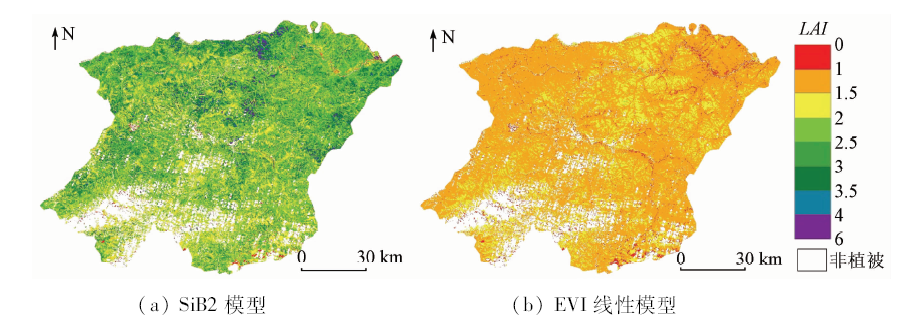
以国产高分一号(GF-1)宽幅数据(wide field of view,WFV)为数据源,采用简单生物圈模型2(simple biosphere model2,SiB2)对黑龙江省漠河县森林植被叶面积指数(leaf area index,LAI)进行估算,并与增强植被指数(enhanced vegetation index,EVI)线性模型的估算结果进行对比,结合地面实测LAI数据分别对这2种模型估算结果进行精度评价。结果表明,采用EVI线性模型估算LAI,决定系数R2为0.582,均方根误差(root mean square error,RMSE)为0.701; 而采用SiB2模型估算LAI,R2为0.798,RMSE为0.358,均比EVI线性模型有所改善。该研究发现,结合中高空间分辨率的GF-1 WFV数据,SiB2模型更适宜于该研究区森林植被的LAI反演。
In this study, domestic GF-1 WFV data were used as the data source, SiB2 model was used to estimate the LAI of forest vegetation in Mohe County of Heilongjiang Province and the value was compared with the estimation result of the enhanced vegetation index (EVI) linear model. Estimation results of the two models were combined with the synchronous ground LAI data for accuracy evaluation. The results show that the coefficient of determination (R2) of the LAI estimated by the EVI linear model is 0.582, and its root mean square error (RMSE) is 0.701. The R2 of the LAI estimated by the SiB2 model is 0.798, and its RMSE is 0.358. Compared with the performance of the EVI linear model, the results estimated by the SiB2 model are improved on both R2 and RMSE. The results show that the SiB2 model is more suitable for LAI inversion of forest vegetation in the study area, in combination with the high spatial resolution GF-1 WFV data.
Chen J M . Canopy architecture and remote sensing of the fraction of photosynthetically active radiation absorbed by boreal conifer forests[J]. IEEE Transactions on Geoscience and Remote Sensing, 1996,34(6):1353-1368.
Liu Y B, Ju W M, Chen J M , et al. Spatial and temporal variations of forest LAI in China during 2000—2010[J]. Chinese Science Bulletin, 2012,57(16):1435-1445.
[3]
Fang H, Liang S, Kuusk A . Retrieving leaf area index using a genetic algorithm with a canopy radiative transfer model[J]. Remote Sensing of Environment, 2003,85(3):257-270.
Cai B F, Shao X . Leaf area index petrieval based on remotely sensed data and PROSPECT+SAIL model[J]. Remote Sensing for Land and Resources, 2007,19(2):39-43.doi: 10.6046/gtzyyg.2007.02.10.
Liu Y, Wu L X, Ma B D . Remote sensing monitoring of soil moisture on the basis of TM/ETM+ spectral space[J]. Journal of China University of Mining and Technology, 2013,42(2):296-301.
Xing L W, Li X J, Li A S , et al. A comparative study on estimation model for leaf area index of vegetation in marshes in Honghe national nature reserve based on hyperspectral and multispectral vegetation indices[J]. Wetland Science, 2013,11(3):313-319.
[8]
Turner D P, Cohen W B, Kennedy R E , et al. Relationships between leaf area index and Landsat TM spectral vegetation indices across three temperate zone sites[J]. Remote Sensing of Environment, 1999,70(1):52-68.
[9]
Sellers P J, Randall D A, Collatz G J , et al. A revised land surface parameterization (SiB2) for atmospheric GCMs.Part I:Model formulation[J]. Journal of Climate, 1996,9(4):676-705.
[10]
Sellers P J, Los S O, Tucker C J , et al. A revised land surface parameterization (SiB2) for atmospheric GCMs,PartII:The generation of global fields of terrestrial biophysical parameters from satellite data[J]. Journal of Climate, 1996,9(4):706-737.
Gao Z Q, Bian L G, Cheng Y J , et al. Modeling of energy budget using simple biosphere model version 2 (SiB2) over Tibetan Naqu prairie[J]. Journal of Applied Meteorological Science, 2002,13(2):129-141.
He Z Q, Shen X Y, Wang Y S , et al. Modeling of the surface turbulence fluxes over a typical steppe prairie in Inner Mongolia,China by using the simple biosphere model 2(SiB2)[J]. Climatic and Environmental Research, 2011,16(3):353-368.
[13]
Boegh E, Soegaard H, Broge N , et al. Airborne multispectral data for quantifying leaf area index,nitrogen concentration,and photosynthetic efficiency in agriculture[J]. Remote Sensing of Environment, 2002,81(2):179-193.
[14]
周以良 . 中国大兴安岭植被[M]. 北京: 科学出版社, 1991: 4-6.
Zhou Y L. Vegetation of Da Hinggan Ling in China[M]. Beijing: Science Press, 1991: 4-6.
Liu S J . Simulation of forest fire growth in an integrated 3D virtual geographical environment in Daxinganling Huzhong area[J].Journal of Anhui Agricultural Sciences, 2015(14):306-310,331.
Sun G F, Qin X L, Yin L Y , et al. Changes analysis of post-fire vegetation spectrum and index based on time series GF-1 WFV images[J]. Spectroscopy and Spectral Analysis, 2018,38(2):511-517.
Zhang M, Yuan H . The PauTa criterion and rejecting the abnormal value[J]. Journal of Zhengzhou University of Technology, 1997,18(1):84-88.
[19]
Zhou M C, Ishidaira H, Hapuarachchi H P , et al. Estimating potential evapotranspiration using Shuttleworth-Wallace model and NOAA-AVHRR NDVI data to feed a distributed hydrological model over the Mekong River basin[J]. Journal of Hydrology, 2006,327(1-2):151-173.
[20]
Sellers P J . Canopy reflectance,photosynjournal,and transpiration[J]. International Journal of Remote Sensing, 1985,6(8):1335-1372.
[21]
Monteith J L, Unsworth M H . Principles of Environmental Physics[M]. London:Edward Arnold, 1990: 290-292.
[22]
Harrison E F, Minnis P, Barkstrom B R , et al. Seasonal variation of cloud radiative forcing derived from the earth radiation budget experiment[J]. Journal of Geophysical Research, 1990,95(d11):18687-18703.
[23]
Sellers P J, Berry J A, Collatz G J , et al. Canopy reflectance,photosynjournal and transpiration.Part III:A re-analysis using improved leaf models and a new canopy integration scheme[J]. Remote Sensing of Environment, 1992,42(3):187-216.
 2019, Vol. 31
  ), 刘树超, 孙桂芬, 刘倩