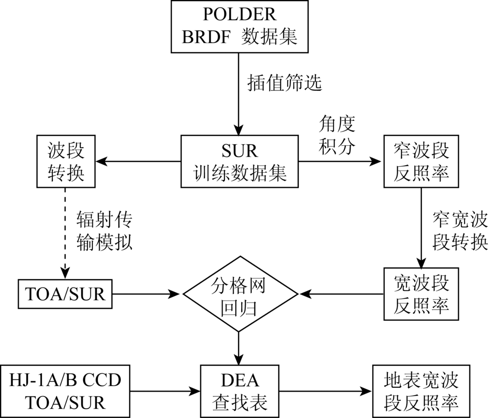
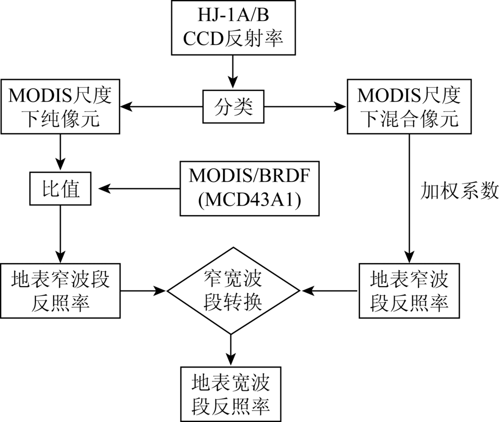
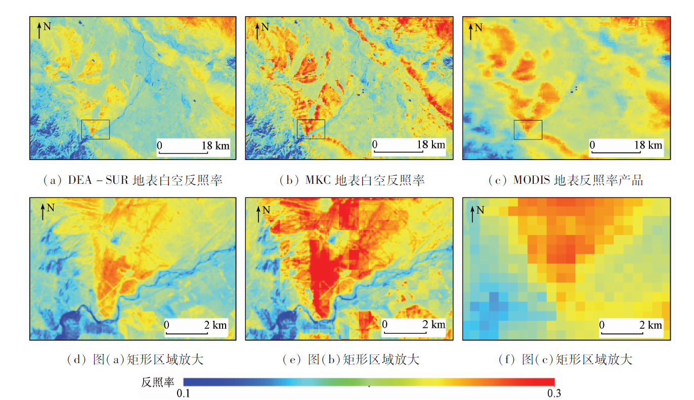
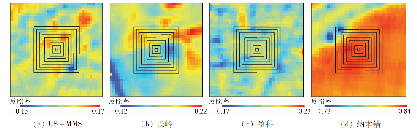
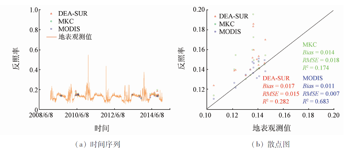
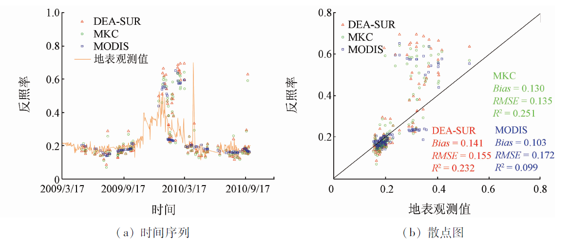
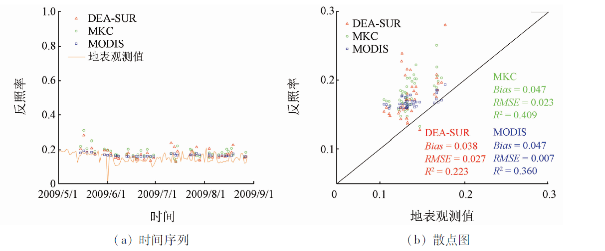
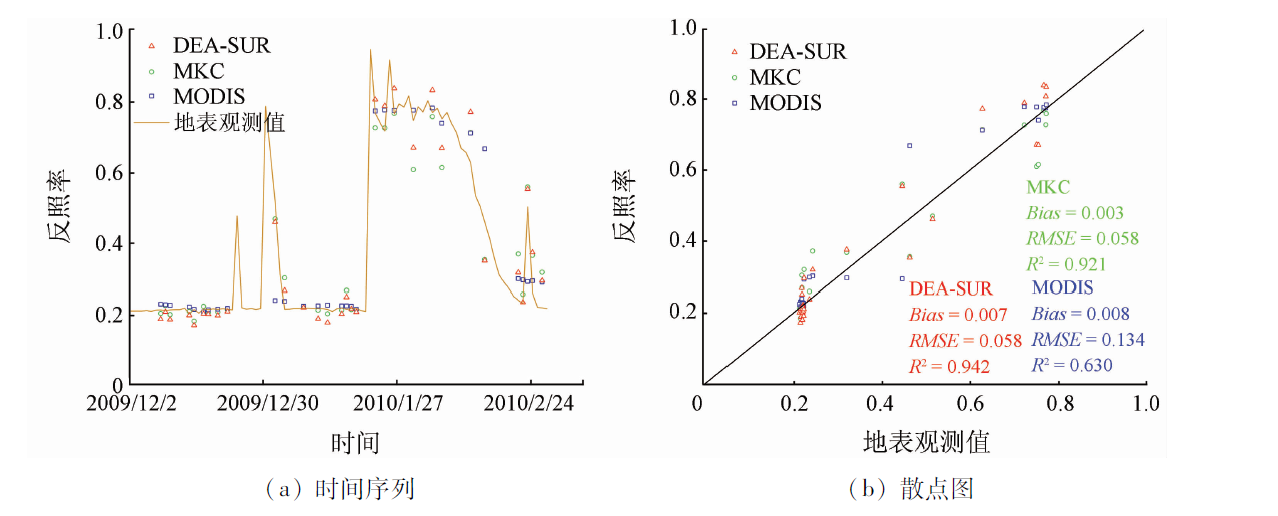
High spatial resolution surface albedo datasets are of critical importance for weather forecast and global climate change studies. The Chinese Huanjing-1 satellites (HJ-1 A/B) can provide wide swath, short revisit time, and high spatial resolution (30 m) remote sensing observations, and hence can be considered as a perfect input data source for generating high spatial resolution surface albedo datasets. In this study, the authors compared and evaluated two methods for estimating surface albedo from HJ-1 A/B CCD data: the direct estimation algorithm from surface reflectance (DEA-SUR) and the method based on MODIS kernel coefficients (MKC). The visual interpretation and clarity index methods were employed for evaluating the fineness of the images. The results show that the clarity and fineness of imagery were greatly improved by the DEA-SUR and MKC methods, compared with the MODIS surface albedo products. It has been demonstrated that the DEA-SUR method is much better than MKC method in avoiding the mosaic effects. Four sites (US-MMS, CN-Cng, Yingke, and Namco) were used for validating and comparing the DEA-SUR and MKC methods. The results show that the DEA-SUR method and the MKC method have similar estimation accuracies during the snow-free period (root mean squared error (RMSE) is 0.015~0.041). In contrast, the estimation error is much larger during the snow-covered period.
Dickinson R E . Land surface processes and climate-surface albedos and energy balance[J]. Advances in Geophysics, 1983,25:305-353.
[2]
Qu Y, Liang S, Liu Q , et al. Mapping surface broadband albedo from satellite observations:A review of literatures on algorithms and products[J]. Remote Sensing, 2015,7(1):990-1020.
[3]
Schaaf C, Gao F, Strahler A , et al. First operational BRDF,albedo nadir reflectance products from MODIS[J]. Remote Sensing of Environment, 2002,83(1-2):135-148.
[4]
Liu Q, Wang L, Qu Y , et al. Preliminary evaluation of the long-term GLASS albedo product[J]. International Journal of Digital Earth, 2013,6(s1):69-95.
[5]
Qu Y, Liu Q, Liang S , et al. Direct-estimation algorithm for mapping daily land-surface broadband albedo from MODIS data[J]. IEEE Transactions on Geoscience and Remote Sensing, 2014,52(2):907-919.
[6]
Riihelä A, Manninen T, Laine V , et al. CLARA-SAL:A global 28 yr timeseries of Earth’s black-sky surface albedo[J]. Atmospheric Chemistry and Physics, 2013,13(7):3743-3762.
[7]
Shuai Y, Masek J G, Gao F , et al. An algorithm for the retrieval of 30-m snow-free albedo from Landsat surface reflectance and MODIS BRDF[J]. Remote Sensing of Environment, 2011,115(9):2204-2216.
[8]
He T, Liang S, Wang D , et al. Evaluating land surface albedo estimation from Landsat MSS,TM,ETM+,and OLI data based on the unified direct estimation approach[J]. Remote Sensing of Environment, 2018,204:181-196.
Sun C K, Liu Q, Wen J G , et al. An algorithm for retrieving land surface albedo from HJ-1 CCD data[J]. Remote Sensing for Land and Resources, 2013,25(4):58-63.doi: 10.6046/gtzyyg.2013.04.10.
[10]
He T, Liang S, Wang D , et al. Land surface albedo estimation from Chinese HJ satellite data based on the direct estimation approach[J]. Remote Sensing, 2015,7(5):5495-5510.
[11]
Gao B, Jia L, Wang T . Derivation of land surface albedo at high resolution by combining HJ-1A/B reflectance observations with MODIS BRDF products[J]. Remote Sensing, 2014,6(9):8966-8985.
Zhang H, Jiao Z D, Li X W , et al. A priori knowledge application in the retrieval of surface albedo using HJ-1 CCD data[J]. Journal of Remote Sensing, 2013,17(2):286-305.
[13]
Qu Y, Liang S, Liu Q , et al. Estimating Arctic sea-ice shortwave albedo from MODIS data[J]. Remote Sensing of Environment, 2016,186:32-46.
[14]
Lewis P, Barnsley M J . Influence of the sky radiance distribution on various formulations of the Earth surface albedo [C]//Proceedings of the Conference on Physical Measurements and Signatures in Remote Sensing.France:ISPRS, 1994: 707-715.
[15]
Pizurica A, Vanhamel I, Sahli H , et al. A Bayesian approach to nonlinear diffusion based on a Laplacian prior for ideal image gradient [C]//IEEE 13th Workshop on Statistical Signal Processing.Bordeaux:IEEE, 2005: 477-482.
[16]
Lucht W, Schaaf C, Strahler A . An algorithm for the retrieval of albedo from space using semiempirical BRDF models[J]. IEEE Transactions on Geoscience and Remote Sensing, 2000,38(2):977-998.
[17]
Jiao Z, Zhang X, Bréon F M , et al. The influence of spatial resolution on the angular variation patterns of optical reflectance as retrieved from MODIS and POLDER measurements[J]. Remote Sensing of Environment, 2018,215:371-385.
 2019, Vol. 31
  )
)