1. National Key Laboratory of Remote Sensing Information and Image Analysis Technology, Beijing Research Institute of Uranium Geology, Beijing 100029, China 2. Zachry Department of Civil Engineering, Texas A&M University, Texas 77843, USA
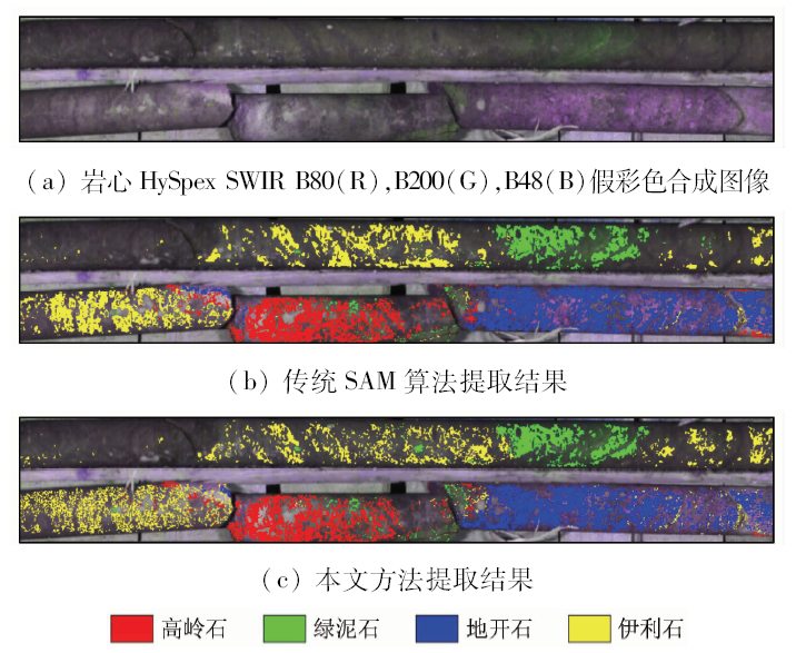
Hyperspectral data are characterized by many bands, but the strong correlation between the adjacent bands makes it redundant and ineffective, which becomes a challenge for information extraction. To solve this problem, this paper proposes a method combining wavelet packet transform and weight SAM. First, radiometric calibration, reflectivity calculation and wavelet denoising are conducted on the raw hyperspectral data. Second, by using daubechies4 as the wavelet basis, the target and reference spectra are both processed with an 8-layer wavelet packet decomposition, and information entropy feature vector is based on the decomposition coefficient to characterize the features of the raw spectra. Third, efforts are made to find the feature range, in which the difference in information entropy feature vector between the target and reference spectra is huge, and a weight in this range is set. Finally, alteration minerals are mapped according to the SAM principle. In this study, experiments were conducted to testify the feasibility and effectiveness of the method by using the HySpex SWIR hyperspectral core data of a volcanic type uranium deposit in southern China. The results indicate that the new algorithm can efficiently characterize the raw spectral information by using the wavelet packet information entropy feature vector. Furthermore, the local characteristic information can be extruded by setting difference feature range, and different minerals can be more easily distinguished by this method with a total classification accuracy of 75.33% and a kappa coefficient of 0.706 3. The method proposed by the authors performs better than the traditional SAM algorithm and has a great application potential.
Yang D C, Chen J, Gao Z H , et al. Extraction of hydrocarbon micro-seepage information based on TG-1 hyperspectral data[J]. Remote Sensing for Land and Resources, 2018,30(2):107-113.doi: 10.6046/gtzyyg.2018.02.15.
Niu Y B, Wang B . A novel target spectrum learning algorithm for small target detection in hyperspectral imagery[J]. Journal of Infrared and Millimeter Waves, 2017,36(4):471-480.
[4]
Mulla D J . Twenty five years of remote sensing in precision agriculture:Key advances and remaining knowledge gaps[J]. Biosystems Engineering, 2013,114(4):358-371.
[5]
Li X K, Wu T X, Liu K , et al. Evaluation of the Chinese fine spatial resolution hyperspectral satellite TianGong-1 in urban land-cover classification[J]. Remote Sensing, 2016,8(5):438-454.
Liu K, Zhang L F, Yang H , et al. Hyperspectral unstructured background target detection approach based on object-oriented analysis[J]. Spectroscopy and Spectral Analysis, 2013,33(6):1653-1657.
[7]
Bedini E . Mineral mapping in the Kap Simpson complex,central East Greenland,using HyMap and ASTER remote sensing data[J]. Advances in Space Research, 2011,47(1):60-73.
Yao J L, Zhang C, Ye F W , et al. Hyperspectral alteration mineral feature and its geological significance of drill core in Zoujiashan uranium deposit of Xiangshan orefield[J]. Uranium Geology, 2017,33(6):376-380.
[9]
Hamza M H , Al-Thubaiti A S,Dhieb M,et al.Dasymetric mapping as a tool to access the spatial distribution of population in Jeddah City (Kingdom of Saudi Arabia)[J]. Current Urban Studies, 2016,4(4):329-342.
He Z H, He B B . Weight spectral angle mapper (WSAM) method for hyperspectral mineral mapping[J]. Spectroscopy and Spectral Analysis, 2011,31(8):2200-2204.
Zhang Y, Zhang J L, Zhao X S , et al. Extraction of mineral alteration information from core hyperspectral images based on weight of absorption peak[J]. Remote Sensing for Land and Resources, 2015,27(2):154-159.doi: 10.6046/gtzyyg.2015.02.24.
Lyu Y L, Li S K, Wang K R , et al. Studies monitoring yield of winter wheat with a modified spectral angle algorithm[J]. Xinjiang Agricultural Sciences, 2011,48(1):1-5.
[13]
Seo Y, Kim S . River stage forecasting using wavelet packet decomposition and data-driven models[J]. Procedia Engineering, 2016,154:1225-1230.
[14]
Zhang X Y, Li P J . Lithological mapping from hyperspectral data by improved use of spectral angle mapper[J]. International Journal of Applied Earth Observation and Geoinformation, 2014,31(5):95-109.
Cen Y, Zhang G Z, Zhang L F , et al. Spectral uncertainty of terrestrial objects and the applicability of spectral angle mapper algorithm[J]. Spectroscopy and Spectral Analysis, 2015,35(10):2841-2845.
Tian M J . Comparative Study of Mineral Mapping Methods Based on Hyperion and SASI Data[D].Beijing:China University of Geosciences ( Beijing), 2017.
[17]
Sankar A S, Nair S S, Dharan V S , et al. Wavelet sub band entropy based feature extraction method for BCI[J]. Procedia Computer Science, 2015,46:1476-1482.
Guo H, Yang K M, Zhang W W , et al. Classification of a hyperspectral image based on wavelet packet entropy feature vector angle[J]. Journal of Image and Graphics, 2017,22(2):205-211.
Zhang C, Ye F W, Xu Q J , et al. Drill core hyperspectral technology system and its application in mineral prospecting[J]. Geological Science and Technology Information, 2016,35(6):177-183.
Zhang C, Ye F W, Yao J L , et al. Implementation method of drill core logging based on imaging spectrometer[J]. Remote Sensing Information, 2017,32(5):69-74.
 2019, Vol. 31