1. College of Public Administration, Nanjing Agricultural University, Nanjing 210095, China 2. National Phosphate Resources Development and Utilization Engineering Technology Research Center, Kunming 650500, China 3. College of Resources and Environment, Nanjing Agricultural University, Nanjing 210095, China
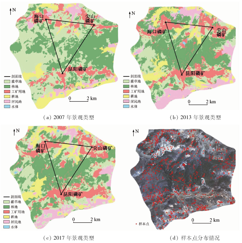
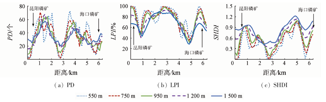
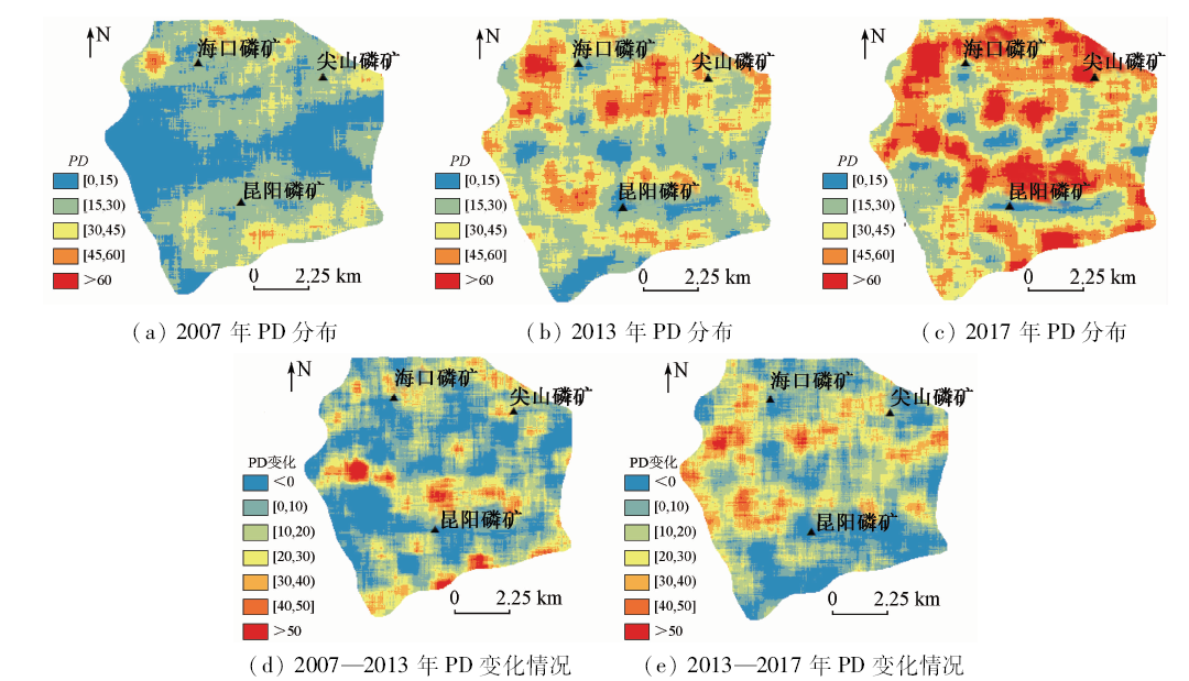
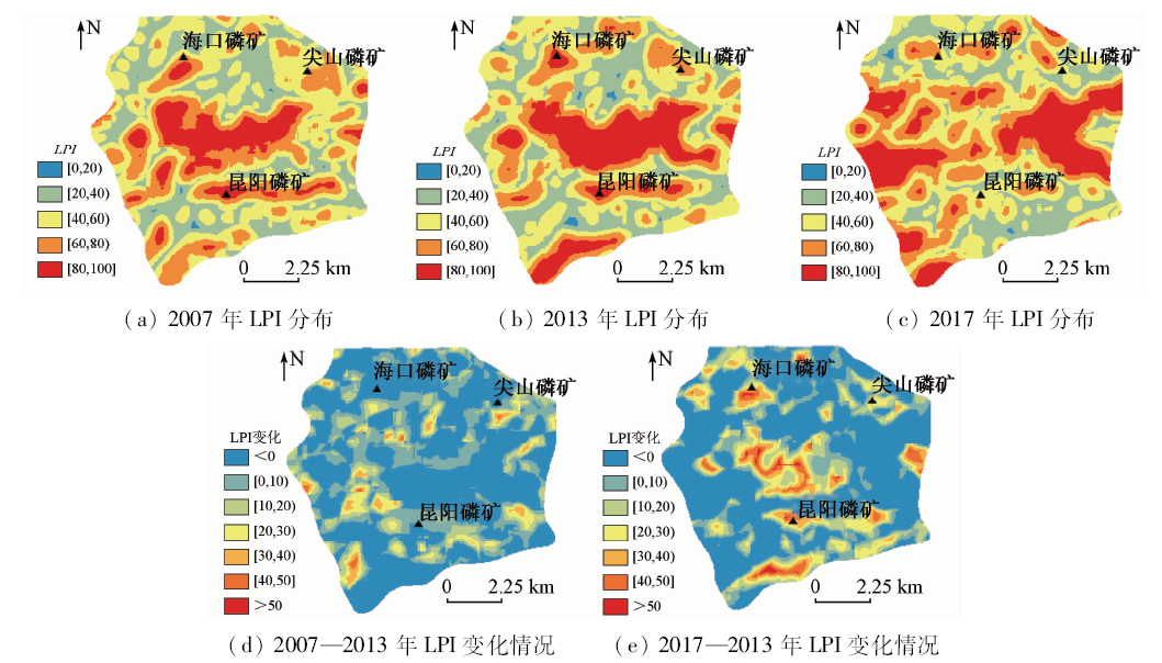
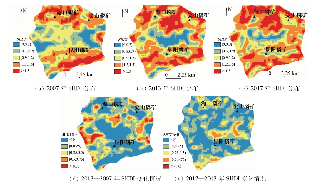
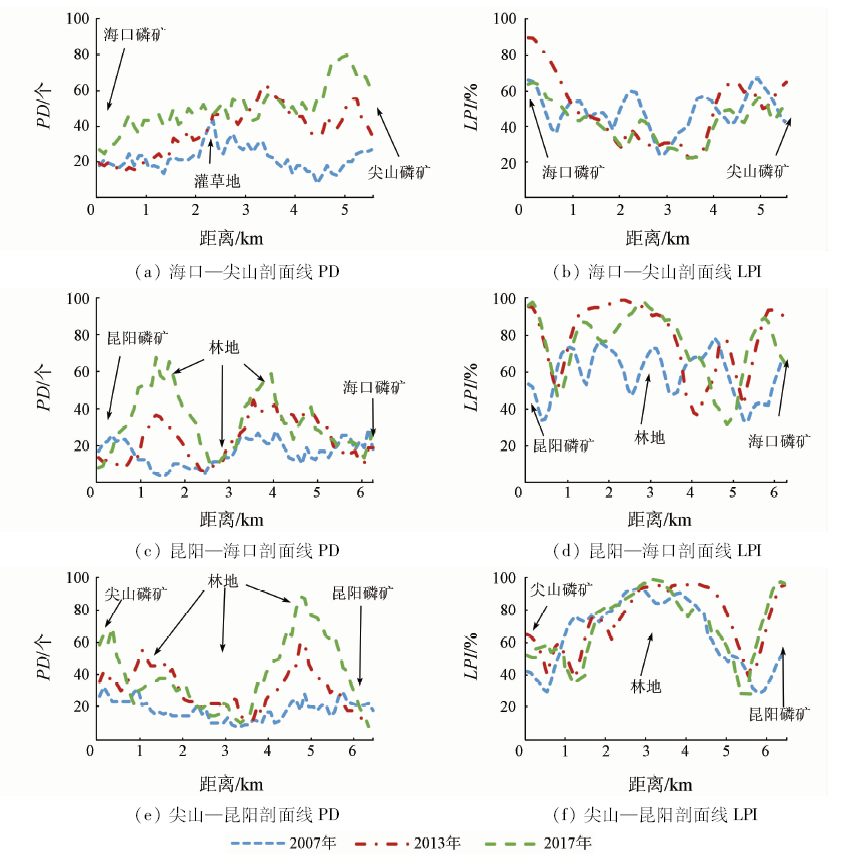
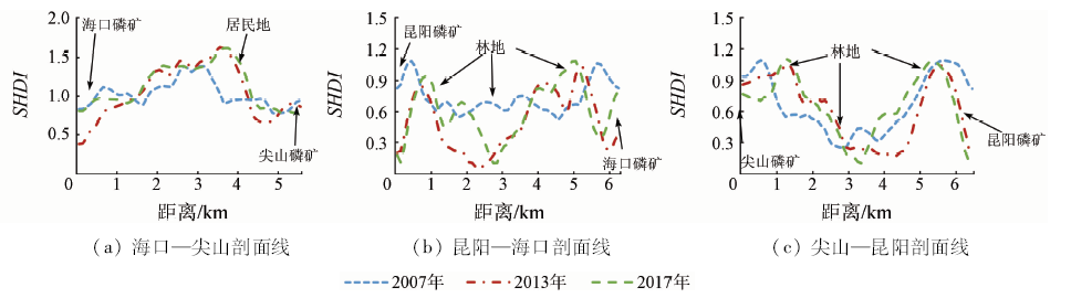
This study is aimed to discuss the temporal and spatial evolution of landscape pattern under the impact of mining work. With the support of moving window analysis and geographic information system (GIS) technology, the authors extracted the spatial distribution map of landscape fragmentation and diversity index from three remote sensing image data in one open-air mining site in Kunming from 2007 to 2017. On the basis of obtaining landscape types and determining appropriate window scales, the spatial distribution maps of landscape fragmentation and diversity index were extracted, and then mining site cores were connected to build transects for spatial overlay analysis. The result shows that, under the most suitable window range of 950 m, the high value center of landscape fragmentation and diversity index spread from the regional edge to the center from 2007 to 2017. The effect of patch aggregation in open mining area was remarkable, and the fragmentation and diversity effect of surrounding area in nearly 1~2 km were obvious year by year. At the same time, the area beyond 2.5 km of the mining center was on the whole not affected by mining activities. The result visually shows the rule for the temporal and spatial evolution of landscape pattern affected by mining activities, and the result can provide data support for follow-up work.
梅昭容, 李云驹, 康翔, 魏善宝, 潘剑君. 基于移动窗口分析法的矿区景观格局时空演变研究[J]. 国土资源遥感, 2019, 31(4): 60-68.
Zhaorong MEI, Yunju LI, Xiang KANG, Shanbao WEI, Jianjun PAN. Temporal and spatial evolution in landscape pattern of mining site area based on moving window method. Remote Sensing for Land & Resources, 2019, 31(4): 60-68.
Su C H, Fu B J . Discussion on links among landscape pattern,ecological process,and ecosystem services[J]. Chinese Journal of Nature, 2012,34(5):277-283.
Chen Y, Chen S J, Du P J , et al. Change analysis of land cover and landscape pattern in coal mining area based on China small satellite remote sensing data[J].Remote Sensing Information,2012(2):85-90.
Han W B, Jia W, Sun T S . Change of land use and landscape pattern in Pingshuo open coal mines based on the 3S technology[J]. China Land Science, 2012,26(4):60-65.
Gao X, Cai X F, Wang J , et al. Analysis of landscape pattern change and its driving forces in typical mining area of Guizhou Province during 10 years[J]. Environment Science and Technology, 2013,36(11):168-174.
Tan L, He X Y, Chen W , et al. Gradient analysis of urban green space landscape pattern in Shenyang City based on QuickBird image[J]. Chinese Journal of Ecology, 2008,27(7):1141-1148.
Xu X R, Xie G Z, Qiu P H , et al.Dynamic analysis of landscape changes in Bamen port and the surrounding lands of Hainan Provience from 1964 to 2015[J]. Acta Ecologica Sinica, 2018(20):1-10.
[9]
Whittaker R H . Vegetation of the Siskiyou Mountains,Oregon and California[J]. Ecological Monographs, 1960,30(4):279-338.
Zhang L L, Zhao Y H, Yin S , et al. Gradient analysis of dry valley of Minjiang River landscape pattern,based on moving window method[J]. Acta Ecologica Sinica, 2014,34(12):3276-3284.
Liu Q, Liu S L, Zhao Q H , et al. Gradient analysis of landscape pattern affected by hydroelectric station based on moving window method[J]. Journal of Mountain, 2012,30(5):628-635.
Li D K, Ding S Y, Liang G F , et al. Landscape heterogeneity of mountainous and hilly area in the western Henan Province based on moving window method[J]. Acta Ecologica Sinica, 2014,34(12):3414-3424.
Zhang L L, Kong F H, Yin H W , et al. Spatial pattern change of Jinan City based on landscape metrics and moving window method[J]. Chinese Journal of Ecology, 2010,29(8):1591-1598.
Xie X Y, Zeng X, Li J . Evaluation of nature suitability for human settlement in Chongqing[J]. Resources and Environment in the Yangtze Basin, 2014,23(10):1351-1359.
Zhang L P, Zhang S W, Ye H C , et al. Landscape indices of land damage and land reclamation in an opencast coal mine[J]. Resource Science, 2014,36(1):55-64.
Lu F L, Wang X C, Zhang H B , et al. Landscape pattern change and its driving force in Jiaozuo mining area from 1980 to 2015[J]. Research of Soil and Water Conservation, 2018,25(4):237-243.
Li C J, Liu L Y, Wang J H , et al. Comparison of two methods of fusing remote sensing images with fidelity of spectral information[J]. Journal of Image and Graphics, 2004,9(11):1376-1385.
Liu E J, Luo Z D, Zhang X L , et al. Comparison of fusion algorithms for GF-1 data from extracted of distribution information on production and construction projects[J].Journal of Soil and Water Conservation,2018(3):358-363.
Song Y T, Jiang D, Huang Y H , et al. Research on the priority of the land use types extraction of opencast mine area based on oriented classification[J]. Remote Sensing Technology and Application, 2016,31(3):572-579.
You L P, Lin G F, Yang C Z , et al. The effects of spatial scales on landscape indices:A case study of the land use pattern of Xiamen Island[J]. Journal of Geo-Information Science, 2008,10(1):74-79.
Xu L, Bian X Q, Qin X L , et al. Effects of grain size change on landscape pattern indices of Heifei City[J]. Chinese Journal of Applied Ecology, 2010,21(5):1167-1173.
 2019, Vol. 31
  )
)