Landslide activity characteristics and stability analysis based on high-resolution remote sensing image: A case study of Dongmiaojia landslide
Weijie JIA1,2, Zhihua WANG1
1. Institute of Geographic Sciences and Natural Resources Research, China Academy of Sciences, Beijing 100101, China 2. China Aero Geophysical Survey and Remote Sensing Center for Natural Resources, Beijing 100083, China
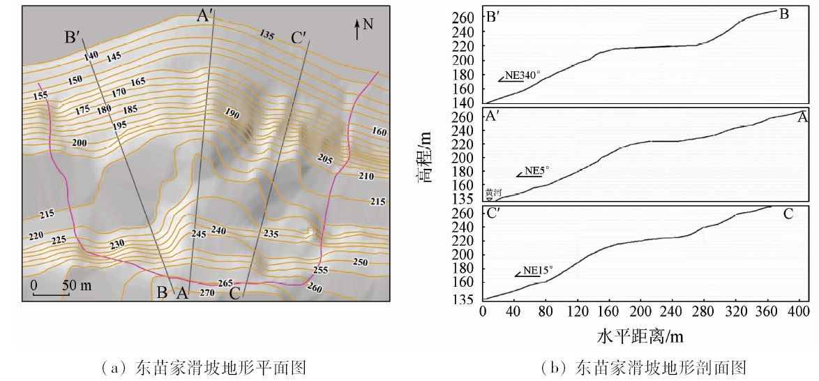
Based on the digital landslide technology, the authors employed revised 10 high-resolution remote sensing images between 2002 and 2016 as remote sensing image information source, densified ASTER DEM data as landslide elevation information source, and 1:200 000 Luoyang City regional geological maps as the geological environment source and, in combination with Dongmiaojia landslide, analyzed the creation conditions and active characteristics of the landslide, and predicted the present stability situation of landslide. The result shows that the active process of Dongmiaojia landslide can be divided into four stages, i.e., the first landslide activity, the subsequent traction activity, the front landslide activity and the follow-up activity, which formed topography of four level terraces with seven platforms and the front steep slope. The estimation of the total size of the Dongmiaojia landslide is 425.4×10 4 m 3. The comparison of ten high-resolution images indicates that there has been no obvious deformation and displacement in the Dongmiaojia landslide in recent years.
贾伟洁, 王治华. 基于高分辨率遥感影像的滑坡活动特征及稳定性分析——以东苗家滑坡为例[J]. 国土资源遥感, 2019, 31(4): 174-181.
Weijie JIA, Zhihua WANG. Landslide activity characteristics and stability analysis based on high-resolution remote sensing image: A case study of Dongmiaojia landslide. Remote Sensing for Land & Resources, 2019, 31(4): 174-181.
Li Q B, Xu G G, and Ying J H . Stability analysis and treatment measures of Dongmiaojia landslide in Xiaolangdi Dam of Yellow river[ C].Chinese Water Conservancy Society Excellent Essays in 1999.Beijing: 1999: 367-371.
Wang X B, Xu W J, and Zhang B Y , et al., Strength reduction of DDA and its application in Dongmiaojia landslide[J]. Journal of Tsinghua University (Science & Technology), 2012,52(6):814-820.
[3]
Xu W J, Jie Y X, Li Q B , et al. Genesis,mechanism,and stability of the Dongmiaojia landslide,Yellow River,China[J]. International Journal of Rock Mechanics & Mining Sciences, 2014,67(2):57-68.
Wang Z H . The application of remote sensing technique to the hydro-electric construction of earlier stage in China[J]. Remote Sensing for Land and Resource, 1995,7(3):1-8.doi: 10.6046/gtzyyg.1995.03.01
[5]
王治华 . 数字滑坡技术及其应用[J]. 现代地质, 2005,19(2):157-164.
Wang Z H , Progress and applications for digital landslide[J]. Geoscience, 2005,19(2):157-164.
[6]
王治华 . 滑坡遥感[M]. 北京: 科学出版社, 2012.
Wang Z H. Remote Sensing for Landslide[M]. Beijing: Science Press, 2012.
[7]
王治华 . 数字滑坡技术及其典型应用[J]. 中国地质调查, 2016,3(3):47-54.
Wang Z H . Digital landslide technology and its typical application[J]. Geological Survey of China, 2016,3(3):47-54.
Li Z J, Teng W F, and Zhou A G , et al. The prediction of reservoir-induced earthquake in Xiaolangdi area,Yellow River[J]. Journal of Geological Hazards and Environment Preservation, 2000,11(4):306-309.
Tong L Q, Guo Z C . A study of remote sensing image features of typical landslides[J]. Remote Sensing for Land and Resource, 2013,25(1):86-92.doi: 10.6046/gtzyyg.2013.01.16.
Hu J C, Zhou Z S, Li C , et al. Dongmiaojia landslide stability evaluation and treatment method[J]. Journal of Zhongyuan University of Technology. 2015,26(6):57-60.
[12]
Jiang X, Wan L, Wang X , et al. Permeability Heterogeneity in a Fractured Sandstone-Mudstone Rock Mass in Xiaolangdi Dam Site,Central China[J]. Acta Geologica Sinica(English,Edition), 2009,83(5):962-970.
Wang Z H, Jia W J . Study on Xintan landslide in Three Gorge based on digital landslide technique[J]. Journal of Engineering Geology, 2017,25(3):762-771.
 2019, Vol. 31