1. College of Civil Engineering and Architecture, Southwest University of Science and Technology, Mianyang 621010, China 2. College of Surveying and Geographic Information, Lanzhou Jiaotong University, Lanzhou 730070, China 3. Institute of Geographic Science and Resources, Chinese Academy of Sciences, Beijing 100101, China
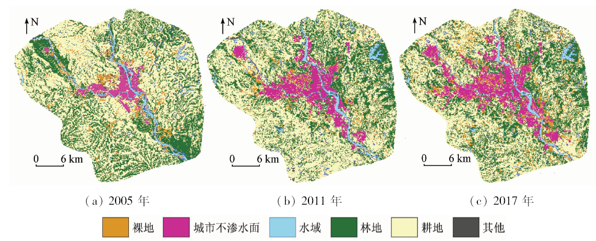
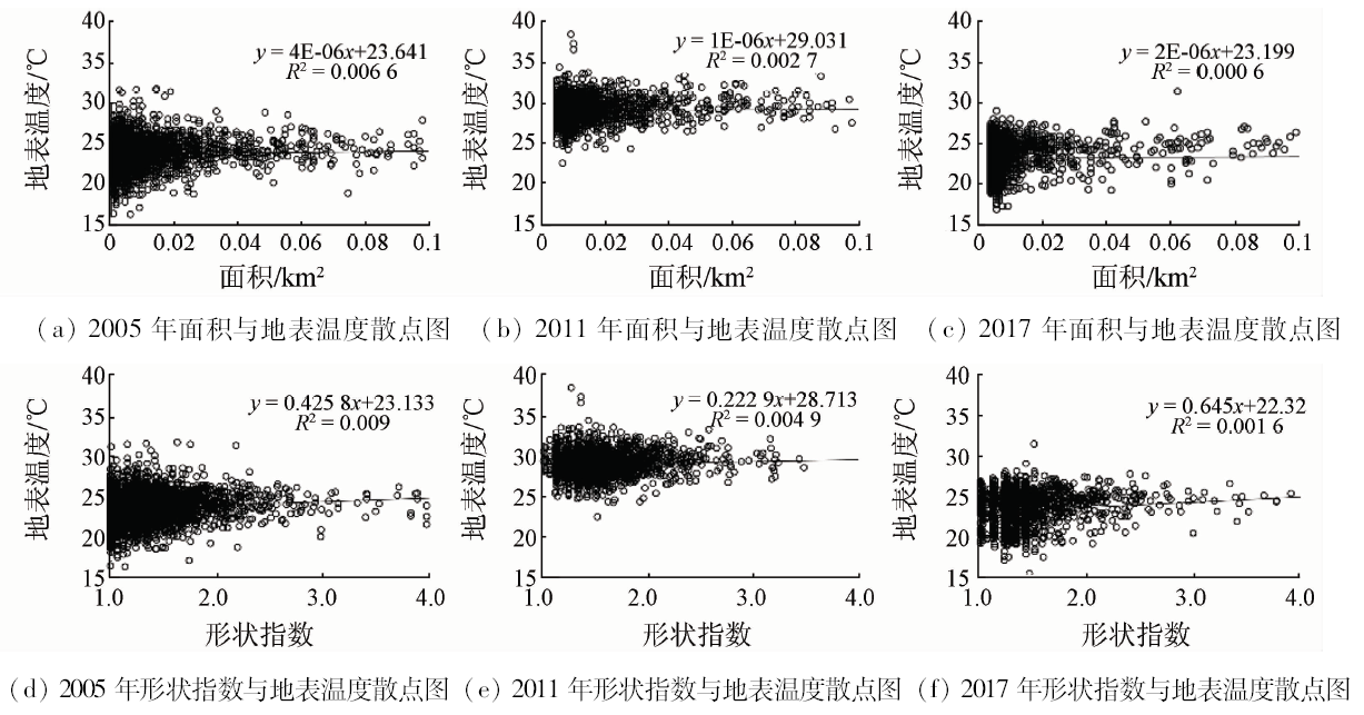
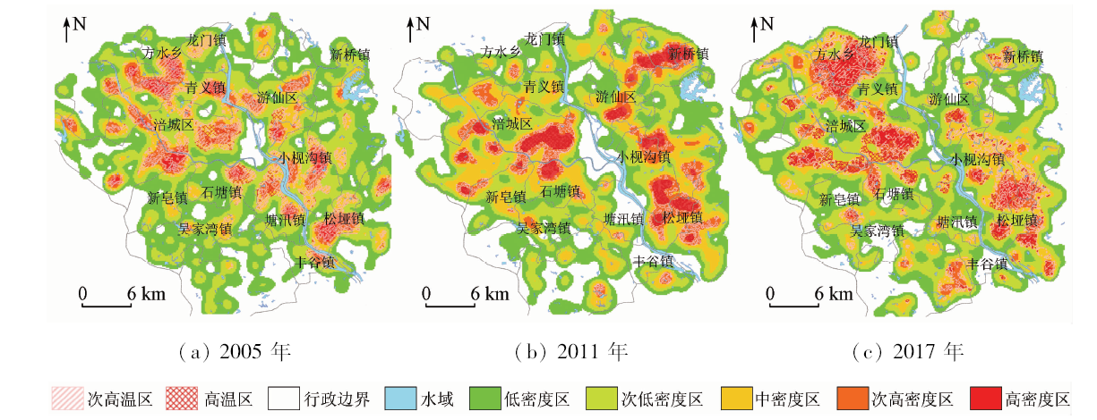
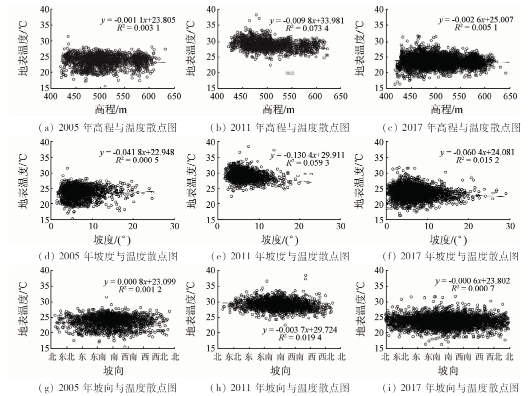
Bare land is considered to be an important source causing urban heat island (UHI) in the urban underlying surface. However, quantitative description of the contribution of bare land to UHI in different periods of urbanization remains vague. Taking three phase Landsat TM/OLI remote sensing images from 2005 to 2017 of Mianyang, a mountain city in southwest China, as the research area and based on inverting the thermal environment response characteristics of land use/land cover change, the authors constructed the contribution index of bare land to UHI effect and analyzed the spatial and temporal changes of the surface thermal environment of bare land in the process of urbanization. The results are as follows: (1) In 2005—2017, bare land accounted for 4.73% (53.98 km 2 in 2005) to 6.34% (72.28 km 2 in 2011) in the study area, showing a trend of “increasing first and then decreasing” with total area (5.54 km 2) decreasing. Bare land was mainly distributed along new roads, urban development zones and urban-rural boundaries. (2) In 2005—2017, with the spatial agglomeration of bare land patches, the surface temperature of bare land in high-density area was significantly higher than that in low-density area, but the influence of bare land topography (elevation, slope, aspect), patch area and shape on the surface temperature of bare land was not significant. (3) In 2005—2017, the absolute difference of surface temperature between bare land and rural areas increased from 1.73 ℃ to 2.12 ℃, which was lower than the temperature of urban impermeable surface and rural area (3.07~3.23 ℃), and the contribution of bare land to urban heat island effect increased from 34% (2005) to 37% (2011) and finally decreased to 20% (2017). This study can provide a scientific basis for evaluating the spatial and temporal changes of urban bare land elements and mitigating the urban heat island effect.
曹琦, 师满江, 周亮, 王婷, 彭黎君, 郑仕雷. 山地城市裸地时空变化的热环境响应特征研究[J]. 国土资源遥感, 2019, 31(4): 190-198.
Qi CAO, Manjiang SHI, Liang ZHOU, Ting WANG, Lijun PENG, Shilei ZHENG. Study of the response characteristics of thermal environment with spatial and temporal changes of bare land in the mountain city. Remote Sensing for Land & Resources, 2019, 31(4): 190-198.
Hansen M C, Egorov A, Potapov P V , et al. Monitoring conterminous United States (CONUS) land cover change with web-enabled Landsat data (WELD)[J]. Remote Sensing of Environment, 2014,140(1):466-484.
Gao H Y, Guo S L, Liu W Z . Characteristics of soil respiration in fallow and its influencing factors at arid-highland of Loess Plateau[J]. Acta Ecologica Sinica, 2011,31(18):5217-5224.
Huang J Q, Zheng Y F, Xu J X , et al. O3 dry deposition flux observation and soil resistance modeling over a bare soil in Nanjing area in autumn[J]. Chinese Journal of Applied Ecology, 2016,27(10):3196-3204.
Xu Q, Li L J, Zhao W H , et al. Spatial distribution of building sites and related emissions of particulate across Beijing,China[J]. Environmental Monitoring in China, 2015,31(5):78-85.
Hu H L, Chen Y H, Gong A D . Advances in the application of remotely sensed data to the study of urban heat island[J]. Remote Sensing for Land and Resources, 2005,17(3). 5-9.doi: 10.6046/gtzyyg.2005.03.02.
Du J L, Zhu J W, Xie J C , et al. An overview of urban land use research based on GIS[J]. Remote Sensing for Land and Resources, 2018,30(3):9-17.doi: 10.6046/gtzyyg.2018.03.02.
[7]
Omran E S E . Detection of land-use and surface temperature change at different resolutions[J]. Journal of Geographic Information System, 2012,4(3):189-203.
Li H, Zeng Y N, Liu Q H . A remote sensing image-based study of the relationship between urban heat island and land use/cover changes in Changsha City[J]. Remote Sensing for Land and Resources, 2008,20(4):47-52.doi: 10.6046/gtzyyg.2008.04.12.
Wang Z B, Yang Y C . Analysing the primary pattern of the space expansion of the mountainous city guided by urban planning[J]. Journal of Mountain Science, 2008,26(6):652-664.
Zhu Z H, Xu G G, Chen X R , et al. Vegetation restoration and ecological protection techniques for road slopes and bare hills[J].Chinese Science and Technology Achievements,2014(16):26-30.
[11]
Estoque R C, Murayama Y . Monitoring surface urban heat island formation in a tropical mountain city using Landsat data(1987—2015)[J]. ISPRS Journal of Photogrammetry and Remote Sensing, 2017,133:18-29.
Han G F, Ye L, Sun Z W . Influence of aspect on land surface temperature in mountainous city:A case study in central area of Chongqing City[J]. Acta Ecologica Sinica, 2014,34(14):4017-4024.
Lyu Z Q, Pang R, Zhu J S , et al. The correlation analysis of surface thermal environment and settlement characteristics in the hilly city[J]. Journal of Chongqing University. 2017,40(5):60-71.
Cai Z, Han G F . Assessing land surface temperature in the mountain city with different urban spatial form based on local climate zone scheme[J]. Journal of Mountain Science, 2018,36(4):617-627.
[15]
刘鑫 . 遥感探测技术在山区城市热环境中的应用研究[D]. 昆明:昆明理工大学, 2011.
Liu X . Application of Remote Sensing Detection Technology in Urban Thermal Environment in Mountainous Areas[D]. Kunming:Kunming University of Technology, 2011.
Kuang W H . Advance and future prospects of urban land use/cover change and ecological regulation of thermal environment[J]. Scientia Geographica Sinica, 2018,38(10):1643-1652.
[17]
Ranagalage M, Estoque R C, Zhang X , et al. Spatial changes of urban heat island formation in the Colombo District,Sri Lanka:Implications for sustainability planning[J]. Sustainability, 2018,10(5):1367.
Li X, Xu H Q, Li J , et al. Extraction of bare soil features from SPOT-5 imagery based on NDSI and NDISI[J]. Journal of Geo-Information Science, 2016,18(1):117-123.
Liu J Y, Ning J, Kuang W H , et al. Spatio-temporal patterns and characteristics of land-use change in China during 2010—2015[J]. Acta Ggeographica Sinica, 2018,73(5):789-802.
[22]
Shi M, Xie Y, Cao Q . Spatiotemporal changes in rural settlement land and rural population in the middle basin of the Heihe River,China[J]. Sustainability, 2016,8(7):614.
Duan Y M, Liu Y, Liu X H , et al. Identification of polycentric urban structure of central Chongqing using points of interest big data[J]. Journal of Natural Resources, 2018,33(5):788-800.
Chi T L, Zeng J, Liu C . A study of evolution mechanism and diffusion mode pattern of thermal environment for Wuhan City in the past 30 years[J]. Remote Sensing for Land and Resources, 2017,29(4):197-204.doi: 10.6046/gtzyyg.2017.04.30.
[25]
王璐瑶 . 武汉土地利用对城市热环境的影响研究[D]. 武汉:华中师范大学, 2016.
Wang L Y . Analysis on the Influence of Land Use on City Thermal Environment[D]. Wuhan:Central China Normal University, 2016.
[26]
Feng H, Zhao X, Chen F , et al. Using land use change trajectories to quantify the effects of urbanization on urban heat island[J]. Advances in Space Research, 2014,53(3):463-473.
 2019, Vol. 31
  ), 周亮2, 王婷3, 彭黎君1, 郑仕雷1