1. College of Computer and Information, Fujian Agriculture and Forestry University, Fuzhou 350002, China 2. Research Center for Resource and Environment Spatial Information Statistics of Fujian Province,Fujian Agriculture and Forestry University, Fuzhou 350002, China
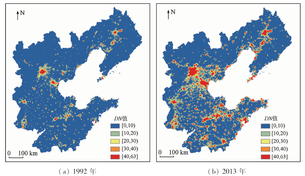
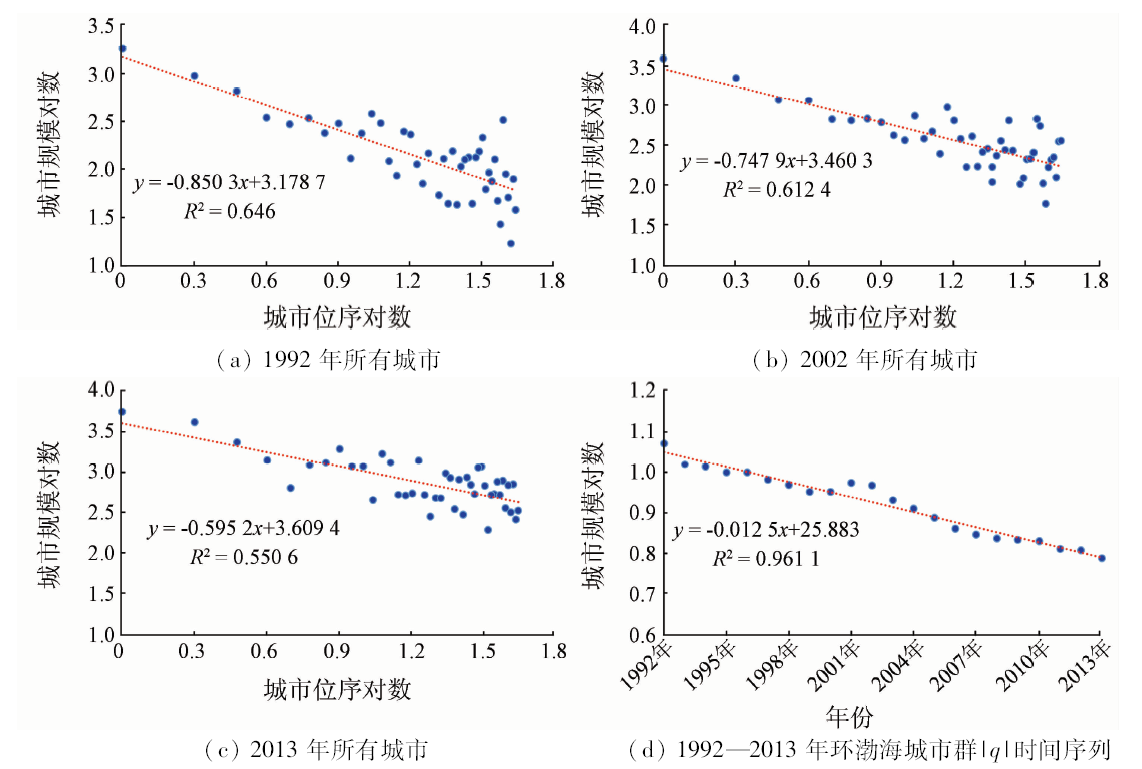
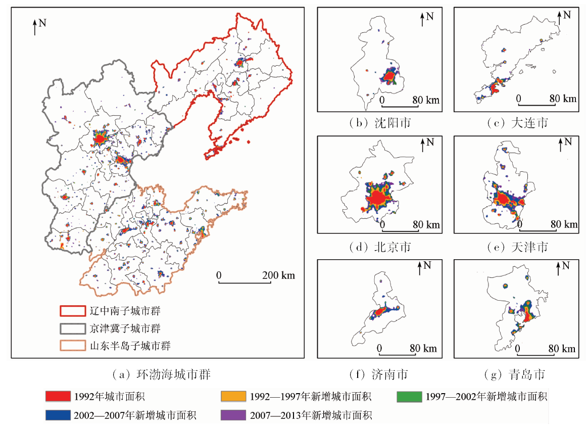
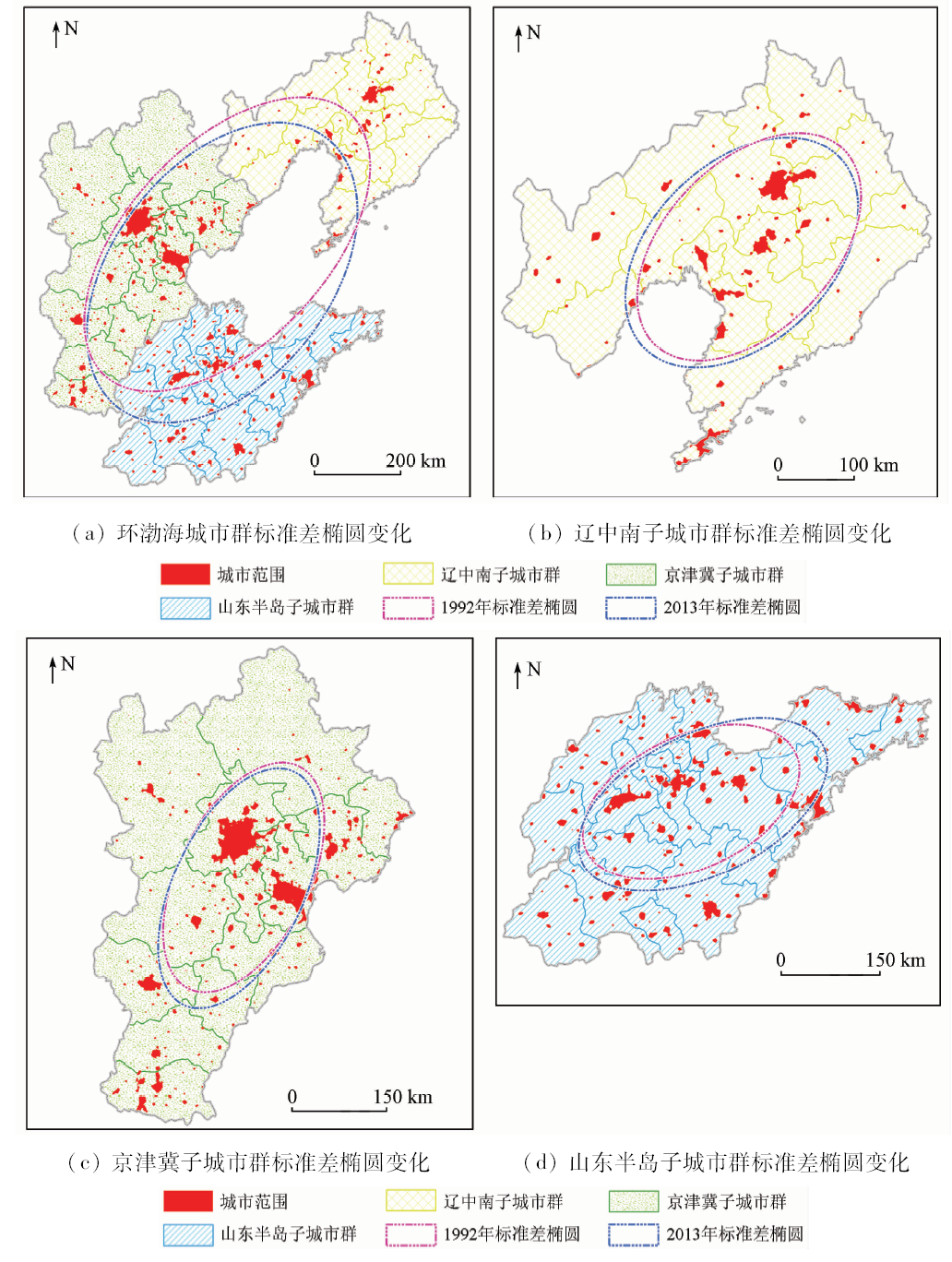
The study of the spatio-temporal evolution of urban agglomeration is of great importance for optimizing the spatial structure of urban agglomeration and promoting the coordinated development of cities. Taking the circum-Bohai urban agglomeration as a study case, the authors revealed the characteristics and objective law of urban evolution process from spatial and temporal dimensions. On the basis of DMSP/OLS night-time light data, the spatial distribution and area of urban from 1992 to 2013 were obtained for the circum-Bohai urban agglomeration. Using the rank-size rule model, the authors determined the size characteristics of urban area. Combined with urban spatial expansion speed index and standard deviation ellipsoid method, the intensity and spatial dynamics of urban area change were clarified in the circum-Bohai urban agglomeration. Some conclusions have been reached: (1) from 1992 to 2013, there was a significant increase of the total night-time lights in the circum-Bohai urban agglomeration, with the overall growth rate being 135.89%. (2) The effect of radiative driving effect of the central cities of the urban agglomeration on the surrounding areas gradually enhanced, and the distribution scale of the urban agglomeration changed from the unbalanced state to the equilibrium state with time. (3) The spatial expansion of the urban agglomeration was characterized by the ring stratification around central cities. The evolution pattern of the urban agglomeration was from west to east and from north to south, and its gravity center shifted to the southwest. It can be inferred that the driving force of the circum-Bohai urban agglomeration development was mainly concentrated in the coastal cities. The study can provide data supports and references for the coordinated development of the circum-Bohai urban agglomeration and even the whole country.
Wu J N, Chen S B, Yao S M . Review and prospect of research on spatial structure of China’s urban agglomerations[J].Modern City Research,2013(12):97-101.
Ni Y, Zhou X C, Jiang W . A reducing saturation method for DMSP/OLS nighttime light image combining Landsat data[J]. Remote Sensing Technology and Application, 2017,32(4):721-727.
Chai B H, Li P J, Zhang R J , et al. Urban expansion extraction using Landsat series data and DMSP/OLS nighttime light data:A case study of Tianjin area[J]. Acta Scientiarum Naturalium Universitatis Pekinensis, 2016,52(3):475-485.
Geng L Y, Ma M G . Advance in method comparison of reconstructing remote sensing time series data sets[J]. Remote Sensing Technology and Application, 2014,29(02):362-368.
Yang M, Wang S X, Zhou Y , et al. Review on applications of DMSP/OLS night-time emissions data[J]. Remote Sensing Technology and Application, 2011,26(1):45-51.
[8]
Castells-Quintana D . Malthus living in a slum:Urban concentration,infrastructure and economic growth[J]. Journal of Urban Economics, 2017,98:158-173.
Li D R, Yu H R, Li X . The spatial-temporal pattern analysis of city development in countries along the Belt and Road Initiative based on nighttime light data[J]. Geomatics and Information Science of Wuhan University, 2017,42(6):711-720.
[10]
Amaral S, Monteiro A M V, Camara G ,et al.DMSP/OLS night-time light imagery for urban population estimates in the Brazilian Amazon[J]. International Journal of Remote Sensing, 2006,27(5):855-870.
Wu J S, Liu H, Peng J , et al. Hierarchical structure and spatial pattern of China’s urban system:Evidence from DMSP/OLS nightlight data[J]. Acta Geographica Sinica, 2014,69(6):759-770.
[12]
Huang Q X, He C Y, Gao B , et al. Detecting the 20 year city-size dynamics in china with a rank clock approach and DMSP/OLS nighttime data[J]. Landscape and Urban Planning, 2015,137:138-148.
Han X D, Zhou Y, Wang S X , et al. GDP Spatialization in China based on DMSP/OLS data and land use data[J]. Remote Sensing Technology and Application, 2012,27(3):396-405.
Liu L . Urban sprawl metrics based on night-time light data for metropolitan areas[J]. Remote sensing for land and resources, 2018,30(2):208-213.doi: 10.6046/gtzyyg.2018.02.28.
Jin M, Deng S Q, Yang C S , et al. Multi-scale clustering analysis on China urban based on nighttime image[J]. Remote Sensing Technology and Application, 2017,32(5):973-982.
Yang Y, Li Y J, He C Y , et al. A comparative study on spatiotemporal dynamics of city size distribution among three urban agglomerations in Bohai rim:Based on the analysis and perspective of nighttime light data from 1992 to 2012[J]. Economic Geography, 2016,36(4):59-69.
Gai M, Zhang L P, Tian C S . Economic development disparities and spatial pattern evolution in Bohai Sea economic zone[J]. Economic Geography, 2013,33(4):22-28.
Wang L, Wang Y Y, Zhang Y . Coupling coordination degree of urban land use benefit and urbanization:A case of 27 cites in the Bohai rim region[J]. Ecological Economy, 2017,33(5):25-28.
Wang L W, Feng C C . Spatial expansion pattern and its driving dynamics of Beijing-Tianjin-Hebei metropolitan region:Based on nighttime light data[J]. Acta Geographica Sinica, 2016,71(12):2155-2169.
He C Y, Li J G, Chen J , et al. The urbanization model and process in Bohai Sea surrounding area in the 1990s by using DMSP/OLA data[J]. Acta Geographica Sinica, 2005,60(3):409-417.
Cao Z Y, Wu Z F, Kuang Y Q , et al. Correction of DMSP/OLS night-time light images and its application in China[J]. Journal of Geo-Information Science, 2015,17(9):1092-1102.
Zou J G, Chen Y H, Tian J , et al. Construction of the calibration model for DMSP/OLS nighttime light images based on ArcGIS[J]. Journal of Geomatics, 2014,39(4):33-37.
Guo J K, Chen Y Y, Yu X H , et al. Rank-size distribution and mechanism of port system in the Bohai rim during the past thirty years[J]. Acta Geographica Sinica, 2017,72(10):1812-1826.
Shu S, Yu B L, Wu J P , et al. Methods for deriving urban built-up area using night-light data:Assessment and application[J]. Remote Sensing Technology and Application, 2011,26(2):169-176.
Wang C Y, Wu G Y, Zhang C . Research on spatial structure of the Chengdu-Chongqing urban agglomeration based on the DMSP/OLS nighttime light data[J]. Urban Development Studies, 2015,22(11):20-24.
 2019, Vol. 31