Extraction of urban built-up areas based on Sentinel-2Aand NPP-VIIRS nighttime light data
Zhili LIU1, Qibin ZHANG1, Depeng YUE1(), Yuguang HAO2, Kai SU1
1. College of Forestry, Beijing Forestry University, Beijing 100083, China 2. Experimental Center of Desert Forestry, Chinese Academy of Forestry, Bayannur 015200, China
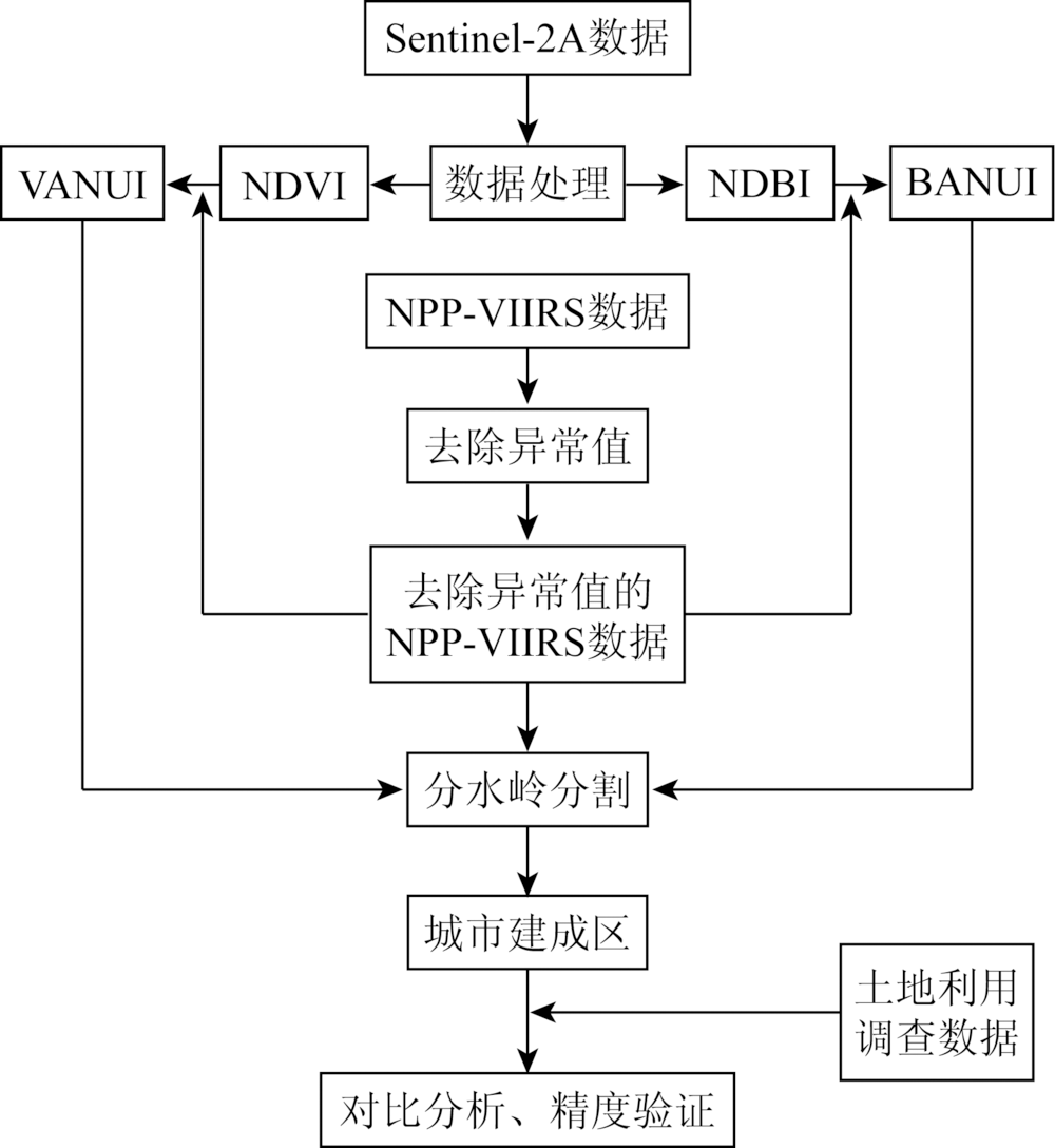
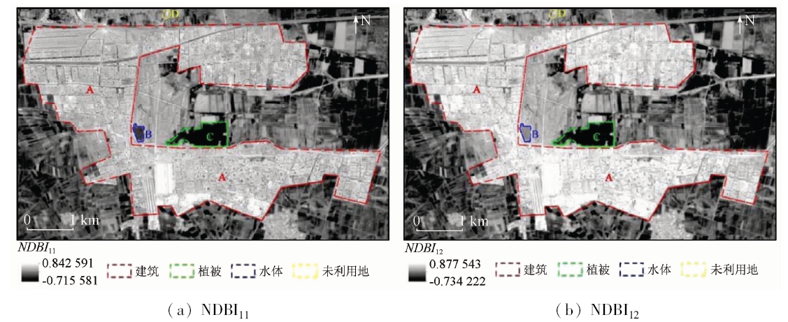
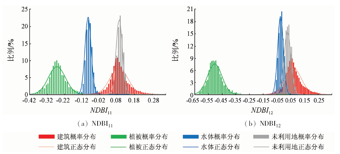
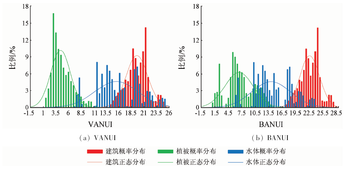
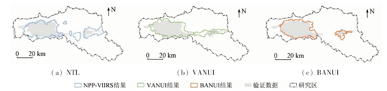
Recently, the utilization of nighttime light data and optical remote sensing images to extract urban built-up areas has become a research hotspot, and the vegetation adjusted nighttime light data (NTL) urban index (VANUI) is widely used. However, it may easily lead to confusion of buildings and water bodies at the edge of the city, and the spatial resolution is relatively low. Therefore, some improvements were made on this index in this paper, and the building adjusted NTL urban index was proposed. The means was used to extract urban built-up areas in Baotou City in this paper. Firstly, normalized difference build-up index (NDBI) was extracted from Sentinel-2A image data and it was combined with NTL to obtain building adjusted NTL urban index BANUI with the spatial resolution of 20 m, which has higher spatial resolution and more information about the building. Finally, the watershed segmentation algorithm was applied to the extraction of urban built-up area of Baotou City from BANUI, VANUI and NTL, and the results were comparatively studied. The extraction results show that the overall precision of the urban built-up area extracted by BANUI could reach 93.61%, the Kappa coefficient is 0.793 4, the user accuracy is 81.34%, and the producer accuracy is 85.34%. The extraction results are consistent with the distribution of actual urban built-up area, and the accuracy is high. The result is better than the area extracted by the other two kinds of data. This method could provide some reference for the study of the extraction of urban built-up area from NTL, and could also be used to monitor the development of urban planning.
Luo T, Liu Y F, Kong X S . System coupling between urbanization and eco-environment:Research progress in China[J]. Tropical Geography, 2014,34(2):266-274.
Li H J, Liu Y L, Tan R H , et al. A new algorithm of urban built-up area boundary extraction based on high-resolution panchromatic image[J].Bulletin of Surveying and Mapping,2015(7):36-41.
Deng L Y, Shen Z F, Ke Y M . Built-up area extraction and urban expansion analysis based on remote sensing images[J]. Journal of Geo-Information Science, 2018,20(7):996-1003.
Li Z, Yang X M, Meng F , et al. The method of multi-source remote sensing synergy extraction in urban built-up area[J]. Journal of Geo-Information Science, 2017,19(11):1522-1529.
[5]
李欣 . 南昌市城市建成区遥感监测及模拟研究[D]. 南昌:东华理工大学, 2017.
Li X . Remote Sensing Monitoring and Simulation Study of Urban Built-up Area in Nanchang City[D]. Nanchang:East China University of Technology, 2017.
Liu L . Urban sprawl metrics based on night-time light data for metropolitan areas[J]. Remote Sensing for Land and Resources, 2018,30(2):208-213.doi: 10.6046/gtzyyg.2018.02.28.
[7]
Zhang Q L, Schaaf C, Seto K C . The vegetation adjusted NTL urban index:A new approach to reduce saturation and increase variation in nighttime luminosity[J]. Remote Sensing of Environment, 2013,129(2):32-41.
[8]
Meng X, Han J, Huang C . An improved vegetation adjusted nighttime light urban index and its application in quantifying spatiotemporal dynamics of carbon emissions in China[J]. Remote Sensing, 2017,9(8):829.
Bi K Y, Niu Z, Huang N, et al.Identifying vegetation with decision tress model based on object-oriented method using multi-temporal Sentinel-2A images[J].Geography and Geo-Information Science , 2017, 33(5):16-20, 27, 127.
Yang B, Li D, Wang L , et al. Retrieval of surface vegetation biomass information and analysis of vegetation feature based on Sentinel-2A in the upper of Minjiang River[J]. Science and Technology Review, 2017,35(21):74-80.
Li X W, Shi H, Zhang Y , et al. Cyanobacteria blooms monitoring in Taihu Lake based on the Sentinel-2A satellite of European Space Agency[J]. Environmental Monitoring in China, 2018,34(4):169-176.
Li F, Mi X N, Liu J , et al. Spatialization of GDP in Beijing using NPP-VIIRS data[J]. Remote Sensing for Land and Resources, 2016,28(3):19-24.doi: 10.6046/gtzyyg.2016.03.04.
Tang M . Urban Built-up Area Extraction From Logarithm Transformed NPP-VIIRS Nighttime Light Composite Data[D]. Shanghai:East China Normal University, 2017.
[14]
Zhang Q L, Seto K C . Mapping urbanization dynamics at regional and global scales using multi-temporal DMSP/OLS nighttime light data[J]. Remote Sensing of Environment, 2011,115(9):2320-2329.
[15]
Yu B L, Tang M, Wu Q S , et al. Urban built-up area extraction from log-transformed NPP-VIIRS nighttime light composite data[J]. IEEE Geoscience and Remote Sensing Letters, 2018,15(8):1279-1283.
Cai H Y, Yao G Q . Optimized method for road extraction from high resolution remote sensing image based on watershed algorithm[J]. Remote Sensing for Land and Resources, 2013,25(3):25-29.doi: 10.6046/gtzyyg.2013.03.05.
[17]
Lewis H G, Brown M . A generalized confusion matrix for assessing area estimates from remotely sensed data[J]. International Journal of Remote Sensing, 2001,22(16):3223-3235.
Guo Y J, Wang Y, Zheng Y , et al. Temporal and spatial evolution of landscapes in Jianhu Lake basin of northwestern Yunnan Province[J]. Journal of Zhejiang A & F University, 2018,35(4):695-704.
Guo S S, Hu S G, Qu S J . Multi-scale analysis of farmland landscape dynamic pattern in the middle reaches of the Yangtze River[J]. Resources and Environment in the Yangtze Basin, 2018,27(7):1637-1646.
 2019, Vol. 31
  ), 郝玉光2, 苏凯1