Please wait a minute...
 
国土资源遥感  2019, Vol. 31 Issue (4): 258-263    DOI: 10.6046/gtzyyg.2019.04.33
  地理信息系统 本期目录 | 过刊浏览 | 高级检索 |
基于多源遥感数据的地理信息质量检测
李冲, 李昊霖(), 佘毅
四川省测绘产品质量监督检验站,成都 610041
Quality inspection of geographic information products based on multi-source remote sensing data
Chong LI, Haolin LI(), Yi SHE
Sichuan Quality Supervision and Testing Center of Surveying and Mapping Product, Chengdu 610041, China
全文: PDF(2386 KB)   HTML  
输出: BibTeX | EndNote (RIS)      
摘要 

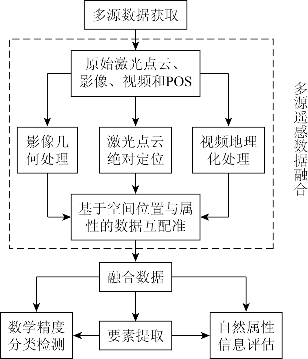
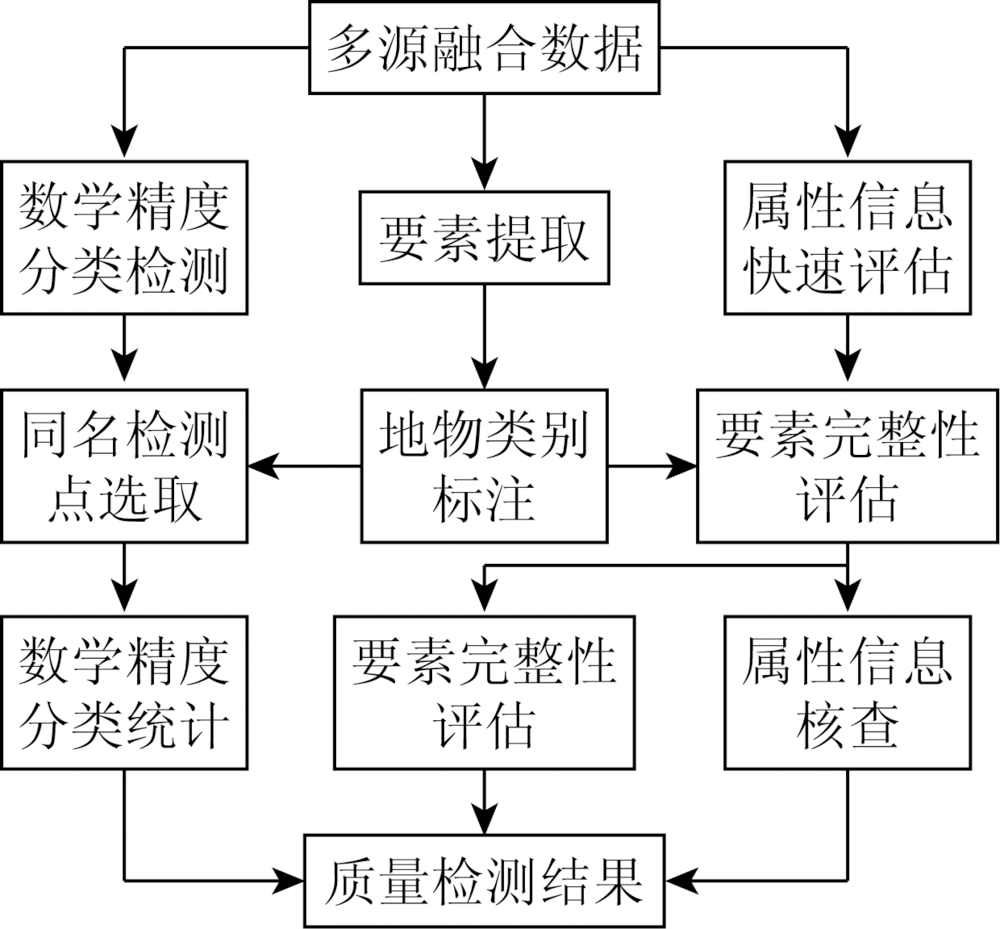
数学精度、要素属性正确性、逻辑一致性是当前地理信息产品质量检测的主要内容,其中精度和属性的检查多采用人工外业实地巡检方式,检测数据的获取具有离散性,属性正确性检查受人为因素影响较大,且该方法劳动强度大、成本高、效率低,对于特殊区域的检查实施困难。通过研究面向地理信息产品质量检测的低空机载激光点云、影像、视频及位置与姿态数据(position and orientation system,POS)的融合处理技术,提出了基于多源低空遥感数据的地理信息产品要素数学精度分类检测与属性评估方法。研究表明,本文方法能够有效用于地理信息产品的质量检测。

服务
把本文推荐给朋友
加入引用管理器
E-mail Alert
RSS
作者相关文章
李冲
李昊霖
佘毅
关键词 激光雷达航空影像地理信息质量检验精度检测    
Abstract

Mathematical precision, correctness of attributes and logical consistency are the main contents of current quality inspection of geographic information products. The inspection of precision and attributes mostly uses manual field inspection methods. This method has several problems: First, the acquisition of test data is discrete; second, the property correctness check is greatly affected by human factors; third, the inspection work has high labor intensity, high cost and low efficiency; fourth, it is difficult to do check and implementation work in special areas. In this paper, the technology of laser point cloud, image, video, POS (position and orientation system) and other data acquired by low-altitude drones for the third-party quality inspection of geographic information products was studied. The attribute evaluation of geographic information products based on multi-source low-altitude remote sensing data is proposed, and the method of mathematical precision classification detection is put forward. The experiment shows that the method proposed in this paper can be applied to the quality inspection of geographic information products.

Key wordsLiDAR    aerial imagery    geographic information    quality inspection    accuracy detection
收稿日期: 2018-10-26      出版日期: 2019-12-03
:  TP79  
基金资助:四川省测绘地理信息局科技支撑项目“多传感器无人机外业巡检系统关键技术研究”(J2017ZC07);国家时空信息基础设施建设与服务关键技术标准研究项目“产品质量及测评技术标准研制”共同资助(2016YFF0201300)
通讯作者: 李昊霖
作者简介: 李 冲(1983-),男,博士研究生,高级工程师,主要从事地理信息成果质量控制研究。Email: 79689585@qq.com。
引用本文:   
李冲, 李昊霖, 佘毅. 基于多源遥感数据的地理信息质量检测[J]. 国土资源遥感, 2019, 31(4): 258-263.
Chong LI, Haolin LI, Yi SHE. Quality inspection of geographic information products based on multi-source remote sensing data. Remote Sensing for Land & Resources, 2019, 31(4): 258-263.
链接本文:  
https://www.gtzyyg.com/CN/10.6046/gtzyyg.2019.04.33      或      https://www.gtzyyg.com/CN/Y2019/V31/I4/258
Fig.1  基于多源遥感数据的产品质量检测流程
Fig.2  机载激光点云绝对定位模型
Fig.3  质量检测步骤
数据类型 数据量/MB 面积/km2 时间 备注
监测数据 41.7 1 208 2017年 待检数据
激光点云 1 034.2 25 2017年4月 参考数据
影像数据 1 925.1 25 2017年4月 参考数据
Tab.1  试验数据信息
Fig.4  数学精度检测点选取
Fig.5  分类别的要素数学精度
Fig.6  要素完整性评估
Fig.7  属性信息核查
方法 获取时间 数据融合处理时间 数学精度检测时间 属性评估时间
本文方法 约12.0 约6.0 约4.0 约6.0
人工外业 约80.0 约4.0 约4.0
Tab.2  检测数据获取及处理时间对比
方法 检测点数/个 中误差/m 评价方式
本文方法 111 3.2 全类别
人工外业 100 3.0 归为一类
Tab.3  产品数学精度检测结果对比
方法 错漏总数 城区错漏数 城郊错漏数
本文方法 50 30 20
人工外业 35 28 7
  产品属性评估结果对比
[1] 张继贤, 顾海燕 . 关于新型测绘的探索[J]. 测绘科学, 2016,41(2):3-10.
Zhang J X, Gu H Y . The exploration of new surveying and mapping[J]. Science of Surveying and Mapping, 2016,41(2):3-10.
[2] 李冲, 邓智文, 何鑫星 , 等. 信息化地理信息产品检查与评价系统构建技术[J]. 地理空间信息, 2017,15(2):12-14.
Li C, Deng Z W, He X X , et al. Quality inspection and evaluation technology for geographic information products[J]. Geospatial Information, 2017,15(2):12-14.
[3] Teng G E, Zhou M, Li C R, et al.Mini-UAV LiDAR for power line inspection[J].ISPRS-International Archives of the Photogrammetry, Remote Sensing and Spatial Information Sciences , 2017, XLII- 2/W7:297-300.
[4] 刘正军 . 大型无人机电力线路巡检数据采集与处理技术[M]. 北京: 中国电力出版社, 2015: 177-181.
Liu Z J. Large UAV Electric Power Line Inspection Data Acquisition and Processing Technology[M]. Beijing: China Electric Power Press, 2015: 177-181.
[5] 李昊霖, 李冲, 黄瑞金 , 等. A3数码航摄仪飞行重叠度检查[J]. 遥感信息, 2015,30(6):58-62.
Li H L, Li C, Huang R J , et al. An overlap check method for A3 digital aerial camera[J]. Remote Sensing Information, 2015,30(6):58-62.
[6] 姚春静 . 机载LiDAR点云数据与遥感影像配准的方法研究[D]. 武汉:武汉大学, 2010.
Yao C J . Research on Registration of LiDAR Point Data and Remote Sensing Images[D]. Wuhan:Wuhan University, 2010.
[7] 董保根 . 机载LiDAR点云与遥感影像融合的地物分类技术研究[D]. 郑州:解放军信息工程大学, 2013.
Dong B G . Research on Classification Technologies of Land Cover by Fusing Airborne LiDAR Point Clouds and Remote Sensing Imagery[D]. Zhengzhou:Information Engineering University, 2013.
[8] 尚大帅, 马东洋, 高振峰 , 等. 机载LiDAR点云数据与影像数据融合[J]. 测绘工程, 2012,21(1):18-20.
Shang D S, Ma D Y, Gao Z F , et al. Data fusion of point cloud and aerial image derived from LiDAR system[J]. Engineering of Surveying and Mapping, 2012,21(1):18-20.
[9] 杨浩 . 基于机载LiDAR点云的真正射影像生成方法研究[D]. 绵阳:中国工程物理研究院, 2015.
Yang H . Research on Generation Method of True Ortho Based on Airborne LiDAR Point Cloud[D]. Mianyang:China Academy of Engineering Physics, 2015.
[10] 谢潇, 朱庆, 张叶廷 , 等. 多层次地理视频语义模型[J]. 测绘学报, 2015,44(5):555-562.
doi: 10.11947/j.AGCS.2015.20140176
Xie X, Zhu Q, Zhang Y T , et al. Hierarchical semantic model of geovideo[J]. Acta Geodaetica et Cartographica Sinica, 2015,44(5):555-562.
[11] 李峰, 刘文龙 . 机载LiDAR系统原理与点云处理方法[M]. 北京: 煤炭工业出版社, 2017: 54-57.
Li F, Liu W L. The Principle of Airborne LiDAR and Approaches of Processing Point Clouds[M]. Beijing: China Coal Industry Publishing House, 2017: 54-57.
[12] 闫利, 蒋宇雯 . 激光点云与航空影像融合分类[J].测绘通报,2015(10):44-46.
Yan L, Jiang Y W . Fusion classification of laser point cloud and airborne image[J].Bulletin of Surveying and Mapping,2015(10):44-46.
[13] 尚大帅 . 机载LiDAR点云数据滤波与分类技术研究[D]. 郑州:解放军信息工程大学, 2012.
Shang D S . Research on Filtering and Classification of Airborne LiDAR Data[D]. Zhengzhou:Information Engineering University, 2012.
[14] 龚亮 . 机载LiDAR点云数据分类技术研究[D]. 郑州:解放军信息工程大学, 2011.
Gong L . Research on Classification of Airborne LiDAR Data[D]. Zhengzhou:Information Engineering University, 2011.
[1] 吴芳, 李瑜, 金鼎坚, 李天祺, 郭华, 张琦洁. 无人机三维地障信息提取技术应用于航空物探飞行轨迹规划[J]. 自然资源遥感, 2022, 34(1): 286-292.
[2] 吴芳, 金鼎坚, 张宗贵, 冀欣阳, 李天祺, 高宇. 基于CZMIL测深技术的海陆一体地形测量初探[J]. 自然资源遥感, 2021, 33(4): 173-180.
[3] 赵龙贤, 代晶晶, 赵元艺, 姜琪, 刘婷玥, 傅明海. 基于RS和GIS技术的西藏多龙矿集区矿山选址研究[J]. 国土资源遥感, 2021, 33(2): 182-191.
[4] 马振宇, 陈博伟, 庞勇, 廖声熙, 覃先林, 张怀清. 基于林火特征分类模型的森林火情等级制图[J]. 国土资源遥感, 2020, 32(1): 43-50.
[5] 李奇, 王建超, 韩亚超, 高子弘, 张永军, 金鼎坚. 基于CZMIL Nova的中国海岸带机载激光雷达测深潜力分析[J]. 国土资源遥感, 2020, 32(1): 184-190.
[6] 陈炫炽, 陈蓉, 吴愈锋, 王跃跃. 基于RS和GIS的都匀茶树种植地质背景调查[J]. 国土资源遥感, 2020, 32(1): 224-231.
[7] 李亚平, 卢小平, 张航, 路泽忠, 王舜瑶. 基于GIS和RUSLE的淮河流域土壤侵蚀研究——以信阳市商城县为例[J]. 国土资源遥感, 2019, 31(4): 243-249.
[8] 杜磊, 陈洁, 李敏敏, 郑雄伟, 李京, 高子弘. 机载激光雷达技术在滑坡调查中的应用——以三峡库区张家湾滑坡为例[J]. 国土资源遥感, 2019, 31(1): 180-186.
[9] 杨思睿, 薛朝辉, 张玲, 苏红军, 周绍光. 高光谱与LiDAR数据融合研究——以黑河中游张掖绿洲农业区精细作物分类为例[J]. 国土资源遥感, 2018, 30(4): 33-40.
[10] 董茜, 李江风, 方世明, 方昆升. 基于GIS的地质公园保护区划分——以湖北神农架世界地质公园为例[J]. 国土资源遥感, 2016, 28(3): 154-159.
[11] 邵秋芳, 彭培好, 黄洁, 刘智, 孙小飞, 邵怀勇. 长江上游安宁河流域生态环境脆弱性遥感监测[J]. 国土资源遥感, 2016, 28(2): 175-181.
[12] 邢宇. 青藏高原32年湿地对气候变化的空间响应[J]. 国土资源遥感, 2015, 27(3): 99-107.
[13] 陈琪, 赵志芳, 何彬仙, 王頔, 习靖. 基于RS和GIS技术的矿山环境恢复与治理规划——以云南省元阳某金矿矿集区为例[J]. 国土资源遥感, 2015, 27(3): 167-171.
[14] 胡莹瑾, 崔海明. 基于RS和GIS的农作物估产方法研究进展[J]. 国土资源遥感, 2014, 26(4): 1-7.
[15] 李晓燕, 姜广辉, 胡磊, 李瑜. 基于GIS与虚拟现实的土地利用总体规划仿真展示平台设计[J]. 国土资源遥感, 2014, 26(4): 195-200.
Viewed
Full text


Abstract

Cited

  Shared   
  Discussed   
京ICP备05055290号-2
版权所有 © 2015 《自然资源遥感》编辑部
地址:北京学院路31号中国国土资源航空物探遥感中心 邮编:100083
电话:010-62060291/62060292 E-mail:zrzyyg@163.com
本系统由北京玛格泰克科技发展有限公司设计开发