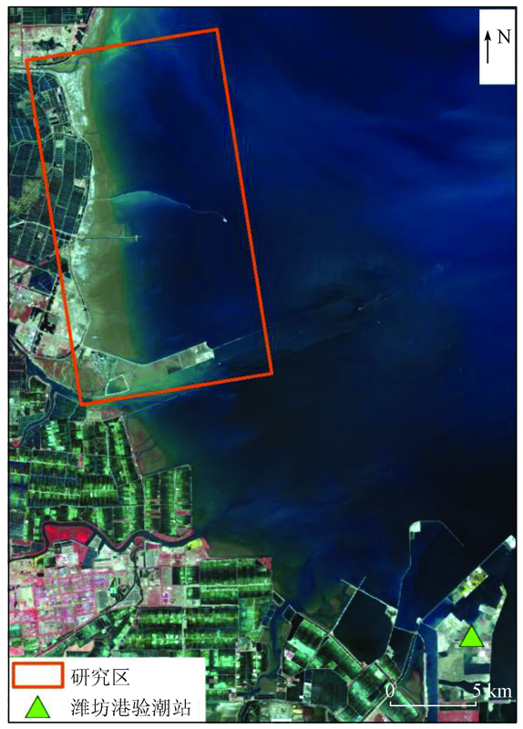
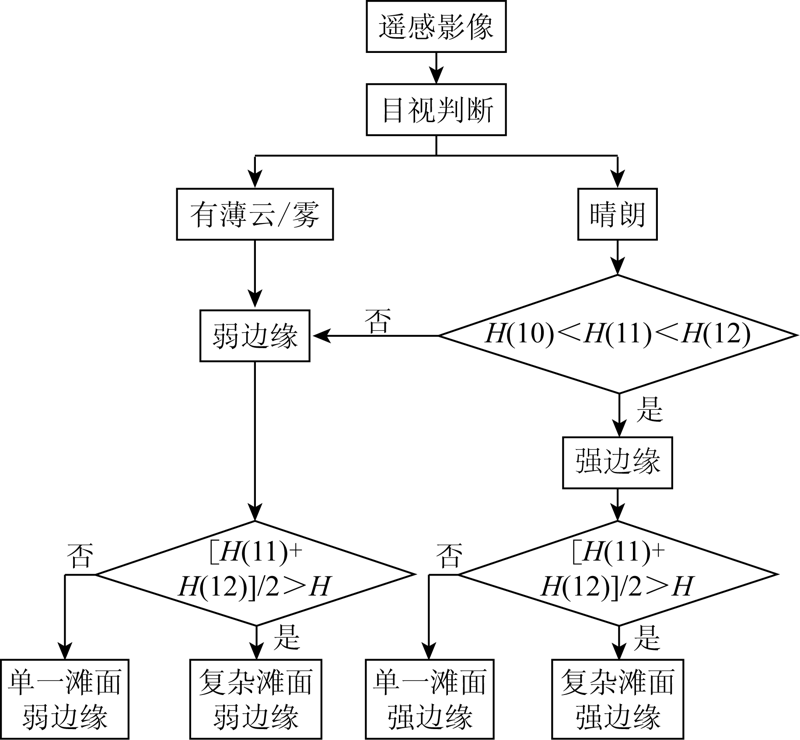
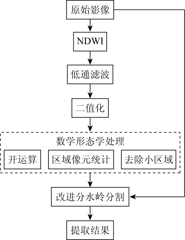
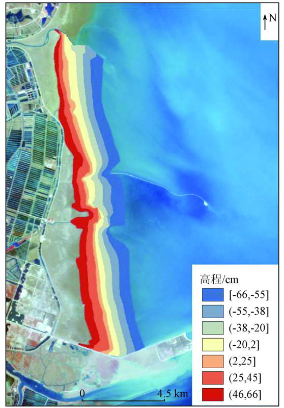
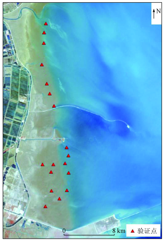
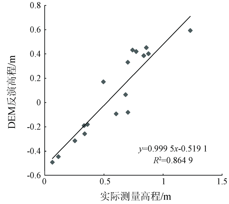
The waterline method is an effective way to obtain a large area of silty tidal flat terrain. Accurate extraction of the waterline is the key to the construction of the tidal flat digital elevation model (DEM). Affected by the tidal conditions and the surface of the tidal flat, the waterlines in different satellite images have large differences in spectrum and texture. It is difficult to extract waterlines accurately using a single method. In this paper, a tidal flat DEM construction method based on multi-algorithm waterline extraction is proposed. The waterlines are classified into four categories according to the tide conditions and are extracted by edge detection, threshold segmentation, object-based segmentation, and improved watershed algorithm respectively. Then, combined with the instantaneous tide level of waterlines, the tidal flat DEM is constructed. In this paper, the method was verified using Laizhou Bay as the research area. There was a high correlation between the inversion elevation and the measured elevation, R2=0.86, and relative error was between 0.31~0.78 m. It is shown that the method in this paper can effectively obtain the approximate topography of the tidal flat.
李天祺, 王建超, 吴芳, 赵政, 张文凯. 基于多算法水边线提取的潮滩DEM构建[J]. 国土资源遥感, 2021, 33(1): 38-44.
LI Tianqi, WANG Jianchao, WU Fang, ZHAO Zheng, ZHANG Wenkai. Construction of tidal flat DEM based on multi-algorithm waterline extraction. Remote Sensing for Land & Resources, 2021, 33(1): 38-44.
Wang B C, Huang Y S. Coastal dynamic geomorphology[M]. Shanghai: East China Normal University Press, 1989: 217-236.
[2]
杨世伦. 海洋环境和地貌过程[M]. 北京: 海洋出版社, 2003: 240.
Yang S L. Coastal environment and geomorphology process[M]. Beijing: Ocean Press, 2003: 240.
[3]
Shi Z, Chen J Y. Morphodynamics and sediment dynamics on intertidal mudflats in China (1961—1994)[J]. Continental Shelf Research, 1996,16(15):1909-1926.
doi: 10.1016/0278-4343(95)00059-3
Ren M D, Liu L, Wang A L. Interpretation of multi-band and multi-temporal satellites for silt and muddy tidal flats[J]. Acta Oceanologica Sinica, 1990,12(6):741-748.
Zheng Z S, Zhou Y X, Liu Z G, et al. DEM reconstruction based on hydrodynamic model and waterline method[J]. Resources and Environment in the Yangtze Basin, 2008,17(5):756-760.
[7]
恽才兴. 海岸带及近海卫星遥感综合应用技术[M]. 北京: 海洋出版社, 2005.
Yun C X. Comprehensive application technology of satellite remote sensing in coastal zone and offshore[M]. Beijing: Ocean Press, 2005.
Qian Y J, Zhang Y, Li H L, et al. Comparison of common edge detection algorithms for waterline extraction in remote sensing images[J]. Yangtze River, 2008,39(13):95-97.
[9]
Ryu J H, Won J S, Min K D. Waterline extraction from Landsat TM data in a tidal flat:A case study in Gomso Bay,Korea[J]. Remote Sensing of Environment, 2002,83(3):442-456.
[10]
Chen A J, Chen C F, Chen K S. Investigation of shoreline change and migration along Wai-San-Ding-Zou barrier island,Central Western Taiwan[C]// 1995 International Geoscience and Remote Sensing Symposium.IEEE, 1995,3:2097-2099.
Li L R, Gao S X, Cao S F. Detection of shoreline in SAR image based on wavelet and GVF Snake model[J]. Hebei Journal of Industrial Science and Technology, 2004,21(4):24-26.
Ju C, Ji C D, Jin L H, et al. The coastline automatic extraction research of object-oriented based on the GF-1 remote sensing image:A case in Qinhuangdao[J]. Geomatics and Spatial Information Technology, 2017,40(12):30-33.
[13]
Mason D C, Davenport I J, Flather R A, et al. A sensitivity analysis of the waterline method of constructing a digital elevation model for intertidal areas in ERS SAR scene of eastern England[J]. Estuarine Coastal and Shelf Science, 2001,53(6):759-778.
Shen F, Gao A, Wu J P, et al. A remotely sensed approach on waterline extraciton of silty tidal construction:A case study in Jiuduansha Shoal of Yangtze River[J]. Acta Geodaetica et Cartographica Sinica, 2008,37(1):106-111.
Mu J, Wu D, Zhu M H, et al. Tidal land digital elevation model establishment based on Beijing-1 small satellite image and high-resolution tidal level grid[J]. Hydrographic Surveying and Charting, 2018,38(1):39-42.
Wu D, Sun J, Huang W Q, et al. Correlation model of waterline detection concerning multi-source images and algorithms[J]. Hydrographic Surveying and Charting, 2014,34(4):50-54.
Liang L, Liu Q S, Liu G H, et al. Review of coastline extraction methods based on remote sensing images[J]. Journal of Geo-Information Science, 2018,20(12):1745-1755.
Duan R L, Li Q X, Li Y H. Summary of image edge detection[J]. Optical Technique, 2005,31(3):415-419.
[19]
Canny J. A computational approach to edge detection[J]. IEEE Transactions on Pattern Analysis and Machine Intelligence, 1986,8(6):679-698.
pmid: 21869365
[20]
McFeeters S K. The use of the normalized difference water index(NDWI) in the delineation of open water features[J]. International Journal of Remote Sensing, 1996,17(7):1425-1432.
[21]
Otsu N. A threshold selection method from gray-level histograms[J]. IEEE Transactions on Systems,Man,and Cybernetics, 2007,9(1):62-66.
Su W, Li J, Chen Y H, et al. Object oriented urban land-cover classification of multi-scale image segmentation method:A case study in Kuala Lumpur city center,Malaysia[J]. Journal of Remote Sensing, 2007,11(4):521-530.
 2021, Vol. 33
  ), 王建超, 吴芳, 赵政, 张文凯