1. Institute of Scientific and Technical Information, Chinese Academy of Tropical Agricultural Sciences/ Key Laboratory of Practical Tropical Crop Information Technology in Hainan, Haikou 570000, China 2. Key Laboratory of Agricultural Remote Sensing, Ministry of Agriculture, Beijing 100100, China
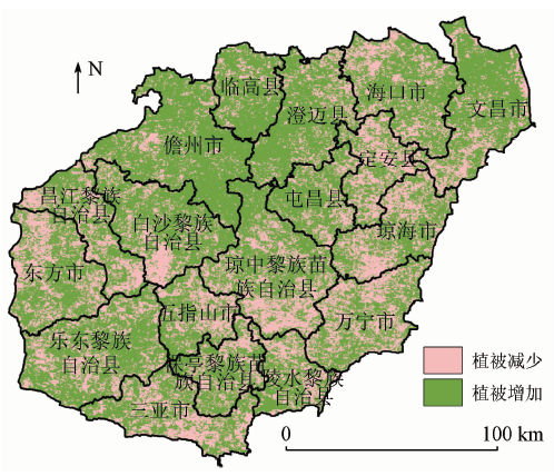
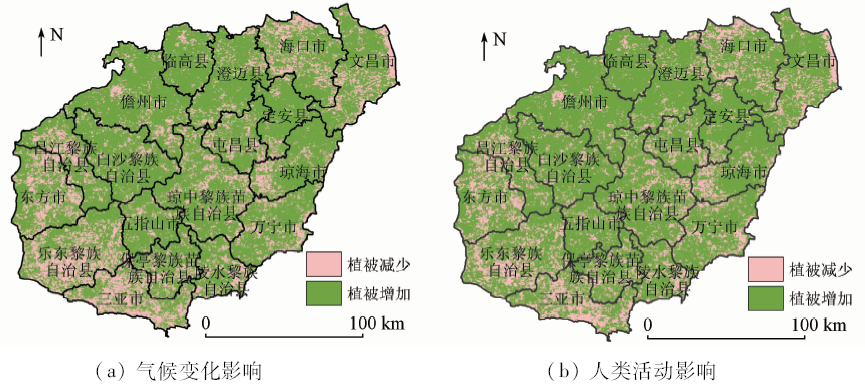
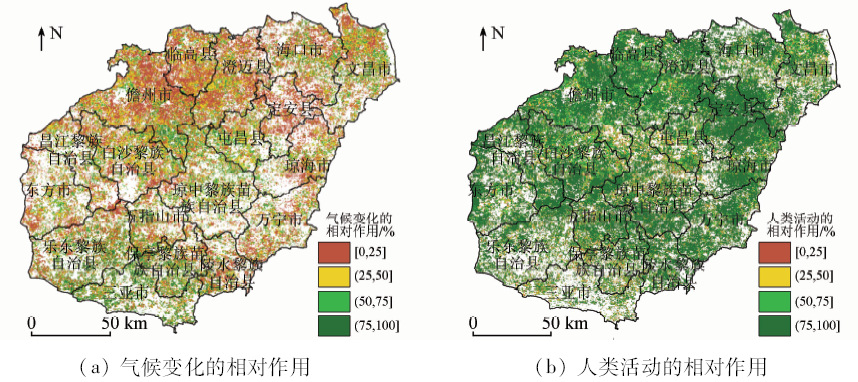
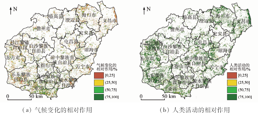
Using MODIS normal difference vegetation index (NDVI) data from 2001 to 2015 and climate data acquired from 7 meteorological stations in Hainan Island, the authors analyzed vegetation variability under the influence of climate variations and human activities based on residual analysis method, unary trend curve regression model and relative role analysis method in Hainan Island. The results showed that NDVI observed by remote sensing (MODIS NDVI) increased over the past 15 years with a rate of 0.024 per ten years in Hainan Island. The proportions of increasing vegetation and decreasing vegetation areas were 77.77% and 22.23%, respectively. As identified by remote sensing observations in Hainan Island, the relative roles of climate changes and anthropogenic activities in vegetation increase areas were 31.04% and 68.96%, while the roles of climate variations and human activities in vegetation decrease areas were 35.03% and 64.97%, respectively, indicating that human activities played a major role in vegetation changes. The area of increased vegetation mainly influenced by human activities (relative role >50%) accounted for 80.79% of the whole increase vegetation area, which was associated with the large-scale rubber plantation in these areas. In contrast, the area of reduced vegetation mainly induced by human activities (relative role > 50%) accounted for 75.59% of the reduced vegetation regions, which may be induced by the increased urbanization and urban expansion in coastal regions. On the whole, climate changes could promote the vegetation growth, whereas human activities played a greater role in the vegetation increasing than in the vegetation decreasing.
Kutiel P, Cohen O, Shoshany M , et al. Vegetation establishment on the southern Israeli coastal sand dunes between the years 1965 and 1999[J]. Landscape and Urban Planning, 2004,67(1-4):141-156.
[2]
Zhang X F, Liao C H, Li J , et al. Fractional vegetation cover estimation in arid and semi-arid environments using HJ-1 satellite hyperspectral data[J]. International Journal of Applied Earth Observation and Geoinformation, 2013,21:506-512.
Bai J J, Bai J T, Wang L . Spatio-temporal change of vegetation NDVI and its relations with regional climate in northern Shaanxi Province in 2000—2010[J]. Scientia Geographic Sinica, 2014,34(7):882-888.
Wang S D, Onyang Z Y, Zhang C P , et al. The dymics of spatial and temporal changes to forested land and key factors driving change on Hainan Island[J]. Acta Ecologica Sinica, 2012,32(23):7364-7374.
[6]
IChii K, Kawabata A, Yamaguchi Y . Global correlation analysis for NDVI and climatic variables and NDVI trends:1982—1990[J]. International Journal of Remote Sensing, 2002,23(18):3873-3787.
[7]
Ren J, Liu H Y, Yin Y , et al. Drivers of greening trend across vertically distributed biomes in temperate arid Asia[J]. Geophysical Research Letters, 2007, 34(7),L07707:1-5.
Liu X F, Pan Y Z, Zhu X F , et al. Spatial temporal variation of vegetation coverage in Qinling-Daba Mountains in relation to environmental factors[J]. Acta Geographica Sinica, 2015,70(5):705-716.
Zhao A Z, Liu X F, Zhu X F , et al. Spatiotemporal analyses and associated driving forces of vegetation coverage change in the Loess Plateau[J]. China Environmental Science, 2016,36(5):1568-1578.
Zhang M, Zhang P S, Liu H B , et al. Study of annual vegetation variability in Hainan Island based on SPOT VEGETATION data[J]. Journal of Southwest University (Natural Science Edition), 2009,31(3):148-153.
Li W G, Tian G H, Zou H P , et al. Typical vegetation area EVI characteristics and responses to meteorological factors in Hainan Island[J]. Chinese Agricultural Science Bulletin, 2014,30(35):190-194.
Lin P S, Li S, Li B S , et al. Correlativity between land desertification and climate variability in west of Hainan Island during past nearly 20 years[J]. Journal of Desert Research, 2005,25(1):27-32.
Chen B Q, Li X P, Xiao X M , et al. Land utilization mapping in Hainan Island by using ALOS PALSAR and multi-temporal Landsat TM/ETM+ imagery[J]. Chinese Journal of Tropical Crops, 2015,36(12):2230-2237.
[14]
Xu Y, Lin S L, He J K , et al. Tropical birds are declining in the Hainan Island of China[J]. Biological Conservation, 2017,210:9-18.
[15]
Sun Y L, Yang Y L, Zhang L , et al. The relative roles of climate variations and human activities in vegetation change in North China[J]. Physics and Chemistry Earth, 2015,87-88:67-78.
Ni J . Development of KIRA’s indices and its application to vegetation climate interaction study of China[J]. Chinese Journal of Applied Ecology, 1997,8(2):161-170.
Zhang C, Li Q, Li Z F . Influence of human activities on variation of vegetation cover in the Three-River Source Region[J]. China Population Resources and Environment, 2014,24(5):139-144.
Ma M G, Wang J, Wang X M . Advance in the inter-annual variability of vegetation and its relation to climate based on remote sensing[J]. Journal of Remote Sensing, 2006,10(3):421-431.
Li S S, Yan J P, Wan J . The spatial-temporal changes of vegetation restoration on Loess Plateau in Shaanxi-Gansu-Ningxia region[J]. Acta Geographica Sinica, 2012,67(7):960-970.
Xu D Y, Kang X W, Liu Z L , et al. Assessing the relative role of climate change and human activities in sandy desertification of Ordos region,China[J]. Science in China Series D(Earth Sciences), 2009,52(6):855-868.
Liu B, Sun Y L, Wang Z L , et al. Analysis of the vegetation cover change and the relative role of its influencing factors in North China[J]. Journal of Natural Resources, 2015,30(1):12-23.
[23]
海南统计局. 海南统计年鉴2001[M]. 北京: 中国统计出版社, 2001.
National Bureau of Statistics of Hainan. Statistical Yearbook of Hainan 2001[M]. Beijing: China Statistics Press, 2001.
[24]
海南统计局. 海南统计年鉴2015[M]. 北京: 中国统计出版社, 2015.
National Bureau of Statistics of Hainan. Hainan Statistical Yearbook 2015[M]. Beijing: China Statistics Press, 2015.
Liu X C, Wang X H, Xing Q . Study on the water conservation function of the ecosystem in the central mountainous area on Hainan Island[J]. Water Saving Irrigation, 2010(7):65-66.
Huang B R, Ouyang Z Y, Zhang H Z , et al. Assessment of eco-environmental vulnerability of Hainan Island,China[J]. Chinese Journal of Applied Ecology, 2009,20(3):639-646.
Wang P, Zheng D, Huang S . The influence factors of urban land expansion and calculation of its utmost scale:A case study of Haikou City[J]. Journal of Shanxi Agricultural University (Social Science Edition), 2018,17(2):44-50.
Zheng Y H, Li S, Wang X Z , et al. Spatio-temporal changes of sandy desertification in recent 50 years in western Hainan Island based on RS and GIS[J]. Journal of Desert Research, 2009,29(1):56-62.
Li S, Liu X W, Sun W . Study of influence of rain shadow region on sandy desertification in west of Hainan Island based on wind tunnel experiments[J]. Journal of Desert Research, 2006,26(2):165-171.
Liao J W, Zhou Y Z . Analysis of drought in western Hainan from the perspective of geographical fringes[J]. Journal of Hainan Normal University (Natural Science), 2012,25(1):104-108.
Diao S J, Liu C L, Zhang T , et al. Extraction of remote sensing information for lake salinity level based on SVM:A case from Badain Jaran desert in Inner Mongolia[J]. Remote Sensing for Land and Resources, 2016,28(4):114-118.doi: 10.6046/gtzyyg.2016.04.18.
 2020, Vol. 32