1. College of Geomatics, Xi’an University of Science and Technology, Xi’an 710054, China 2. School of Remote Sensing and Information Engineering, Wuhan University, Wuhan 430079, China
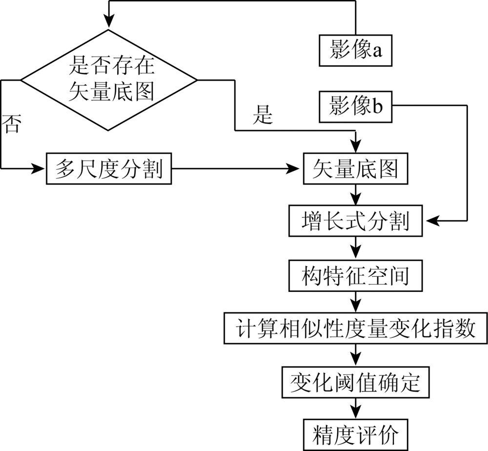
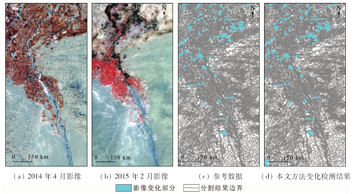
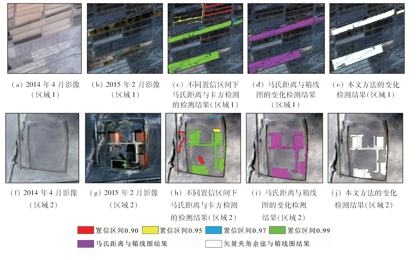
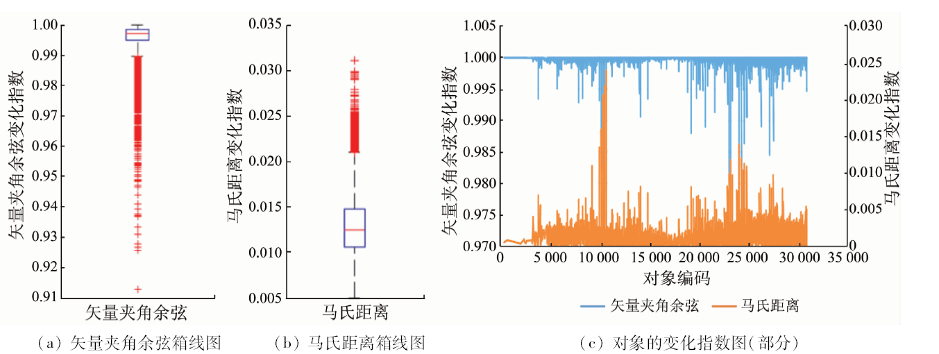
The traditional statistics-based change detection method requires the prerequisite that the dataset should obey the Gaussian distribution, such as the iterative chi-square test based change detection method. However, the dataset does not strictly obey the Gaussian distribution, and hence the result is not ideal. A novel change detection method is proposed in this paper, which does not need any assumptions and can take change detection by its own structure. First, an incremental segmentation method is adapted to get objects. After that, spectral and contextual features are combined to calculate its cosine value. Finally, changed objects are found by the box-plot. High-resolution remote sensing images of GF-1 are used as the experimental data. The results are much better than the results of the traditional statistical object-based change detection.
Zhao Z M, Meng Y, Yue A Z, et al. Review of remotely sensed time series data for change detection[J]. Journal of Remote Sensing, 2016,20(5):1110-1125.
[3]
Coppin P, Jonckheere I, Nackaerts K, et al. Digital change detection methods in ecosystem monitoring:A view[J]. International Journal of Remote Sensing, 2004,25(9):1565-1596.
[4]
Falowski M J, Wulder M A, White J C, et al. Supporting large-area, sample-based forest inventories with very high spatial resolution satellite imagery[J]. Progress in Physical Geography, 2009,33(3):403-423.
[5]
Hay G J, Hemchandran B, Kyle C D. HEAT (home energy assessment technologies):Residential waste heat monitoring,google maps and airborne thermal imagery [C]//Proceedings of the ISPRS Conference GEOBIA.ISPRS, 2010.
[6]
Fisher P F, Comber A J, Wadsworth R. Land use and land cover:Contradiction or complement[G].Fisher P F,Re-Presenting GIS.Hoboken:John Wiley and Sons Ltd., 2005: 85-98.
[7]
Hussain M, Chen D, Cheng A, et al. Change detection from remotely sensed images:From pixel-based to object-based approaches[J]. ISPRS Journal of Photogrammetry and Remote Sensing, 2013,80(2):91-106.
Zhao M. Object-oriented and multi-feature hierarchical change detection based on CVA for high-resolution remote sensing imagery[J]. Journal of Remote Sensing, 2018,22(1):119-131.
[9]
Chen G, Hay G J, Carvalho L M T,et al.Object-based change detection[J]. International Journal of Remote Sensing, 2012,33(14):4434-4457.
[10]
Janalipour M, Taleai M. Building Change detection after earthquake using multi-criteria decision analysis based on extracted information from high spatial resolution satellite images[J]. International Journal of Remote Sensing, 2017,38(1):82-99.
doi: 10.1080/01431161.2016.1259673
[11]
Yang X T, Liu H P, Gao X F. Land cover changed object detection in remote sensing data with medium spatial resolution[J]. International Journal of Applied Earth Observations and Geoinformation, 2015,38:129-137.
[12]
Liang L, Ying G, Wen X, et al. Object-oriented change detection based on spatiotemporal relationship in multitemporal remote-sensing images [C]//36th International Symposium on Remote Sensing of Environment.IAPRS, 2015: 1241-1248.
[13]
Moghadam N K, Delavar M R, Forati A. Vegetation monitoring of mashhad using an object-oriented POST classification comparison method[J]. 2017 Tehran’s Joint ISPRS Conferences of GI Research,SMPR and EOEC,IAPRS, 2017: 123-131.
[14]
An K, Zhang J S, Xiao Y. Object-oriented urban dynamic monitoring:A case study of Haidian Distirict of Beijing[J]. Chinese Geographical Science, 2007,17(3):236-242.
[15]
Peng D F, Zhang Y J. Object-based change detection from satellite imagery by segmentation optimization and multi-features fusion[J]. International Journal of Remote Sensing, 2017,38(13):3886-3905.
doi: 10.1080/01431161.2017.1308033
[16]
Desclée B, Bogaert P, Defourny P. Forest change detection by statistical object-based method[J]. Remote Sensing of Environment, 2006,102(1):1-11.
[17]
Bontemps S, Bogaert P, Titeux N, et al. An object-based change detection method accounting for temporal dependences in time series with medium to coarse spatial resolution[J]. Remote Sensing of Environment, 2008,112(6):3181-3191.
doi: 10.1016/j.rse.2008.03.013
Li C G, Dai H B. Statistical object-based method for forest change detection using high-resolution remote sensing image[J]. Scientia Silvae Sinicae, 2017,53(5):74-81.
Wu S, Wei Z B, Wang S Z, et al. The damage identification method based on AR model and principal component analysis[J]. Journal of Vibration,Measurement and Diagnosis, 2012,32(5):841-845.
[20]
Li X, Yeh A G O, Qian J, et al.A matching algorithm for detecting land use changes using case-based reasoning[J]. Photogrammetric Engineering and Remote Sensing, 2009,75(11):1319-1332
doi: 10.14358/PERS.75.11.1319
[21]
Im J, Jensen J R, Tullis J A. Object-based change detection using correlation image analysis and image segmentation[J]. International Journal of Remote Sensing, 2008,29(2):399-423.
[22]
Ouma Y O, Tetuko J, Tatteishi R. Analysis of co-occurrence and discrete wavelet transform textures for differentiation of forest and non-forest vegetation in very-high-resolution optical-sensor imagery[J]. International Journal of Remote Sensing, 2008,29(12):3417-3456.
[23]
Tukey J W. Exploratory data analysis[J]. Journal of the American Statistical Association, 1977,26(2):163-182.
Gong J J, Li F L, Yang G G, et.al.The application of box-plot method to determining geochemical anomaly thresholds based on VBA procedure in Excel[J]. Geophysical and Geochemical Exploration, 2013,37(5):926-933.
 2020, Vol. 32