Please wait a minute...
 
国土资源遥感  2020, Vol. 32 Issue (2): 40-45    DOI: 10.6046/gtzyyg.2020.02.06
  技术方法 本期目录 | 过刊浏览 | 高级检索 |
无人机影像稳健区域网平差
薛武1, 赵玲2, 于英3
1.航天工程大学太空安全研究中心,北京 101416
2.91039部队,北京 102400
3.信息工程大学地理空间信息学院,郑州 450001
Robust bundle adjustment for UAV images
Wu XUE1, Ling ZHAO2, Ying YU3
1. Space Security Research Center, Space Engineering University, Beijing 101416, China
2. 91039 Troops, Beijing 102400, China
3. School of Geospatial Information, Information Engineering University, Zhengzhou 450001, China
全文: PDF(5050 KB)   HTML  
输出: BibTeX | EndNote (RIS)      
摘要 

针对无人机影像区域网平差中误匹配点较多,采用方差损失函数可能造成求解参数失真,偏离真值误差大,甚至无法收敛的问题,采用了一种顾及观测值可靠性的稳健区域网平差方法。该方法采用损失函数作为粗差抑制策略,是在Cauchy损失函数基础上的一种变体,主要思想为根据特征点重叠度的均值、方差以及残差大小自适应调整总体损失函数,从而克服误匹配点对平差参数求解的干扰,并设计了不依赖地面控制点的精度评价实用方法。实验表明,该方法在较高误匹配率的情况下,仍然能够得到稳健的平差结果,具有一定实用价值。

服务
把本文推荐给朋友
加入引用管理器
E-mail Alert
RSS
作者相关文章
薛武
赵玲
于英
关键词 无人机影像误匹配点稳健损失函数    
Abstract

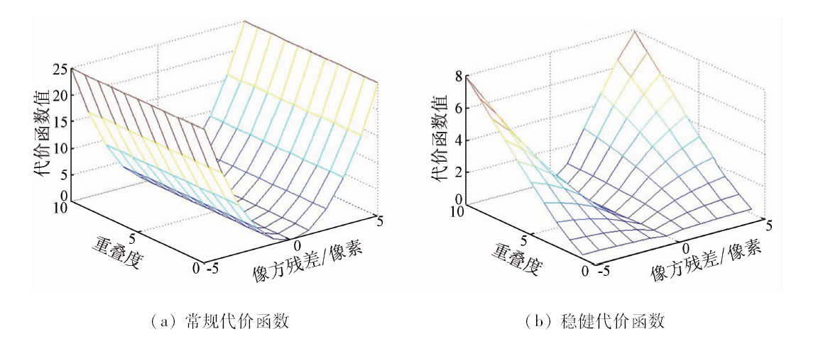
Aimed at tackling the problems that there are many mismatched points in the bundle adjustment of unmanned aerial vehicle (UAV) images, the variance loss function may cause the distortion of the solution parameters, and there exists large deviation from the true value which even causes impossibility of converge, the authors applied a robust bundle adjustment method considering the reliability of the observation value. This method uses loss function as a strategy to suppress gross errors, and is a variant designed on the basis of Cauchy loss function. The main idea of this method is adjusting the total loss function adaptively according to the mean value and variance of overlap degree and the residual of feature points, so as to overcome the influence of mismatched points on the computation of image parameters. Correspondingly, a practical accuracy evaluation method independent of ground control point (GCP) was designed. Experiments show that the method can still get robust adjustment results with high mismatch rate, and hence it is practical.

Key wordsUAV image    mismatch points    robust    loss function
收稿日期: 2019-06-21      出版日期: 2020-06-18
:  TP79  
基金资助:航天工程大学青年创新基金项目
作者简介: 薛 武(1988-),男,博士,助理研究员,研究方向为无人机摄影测量与计算机视觉。Email: xuewu_81@126.com。
引用本文:   
薛武, 赵玲, 于英. 无人机影像稳健区域网平差[J]. 国土资源遥感, 2020, 32(2): 40-45.
Wu XUE, Ling ZHAO, Ying YU. Robust bundle adjustment for UAV images. Remote Sensing for Land & Resources, 2020, 32(2): 40-45.
链接本文:  
https://www.gtzyyg.com/CN/10.6046/gtzyyg.2020.02.06      或      https://www.gtzyyg.com/CN/Y2020/V32/I2/40
Fig.1  代价函数曲面图
Fig.2  对极几何示意图
区域 影像数量/幅 平台 相机 像幅/像素 航摄时间 行政区划 航高/m 地面分辨率/cm
A 1 209 智能鸟无人机 Canon EOS 5DS 8 688×5 792 2015年10月 内蒙古自治区 700 10.0
B 186 无人直升机 Phase One IQ180 10 328×7 760 2015年10月 河南省 500 5.0
C 563 天宝无人机 SONY_α5100 6 000×4 000 2016年4月 河南省 150 4.0
D 433 天宝无人机 SONY_α5100 6 000×4 000 2016年4月 河南省 150 4.0
Tab.1  实验数据基本情况

同名点数量
(物方/像方)
原始数据 5% 噪声 10% 噪声 15% 噪声 20% 噪声 25% 噪声
BA RBA BA RBA BA RBA BA RBA BA RBA BA RBA
A 68 238/141 592 1.03 0.71 2.32 0.76 4.68 0.81 × 1.33 × 1.50 × 2.84
B 532 324/2 309 275 0.99 0.58 1.21 0.66 3.25 0.72 × 1.29 × 2.01 × ×
C 206 543/454 724 1.23 0.72 1.56 0.84 6.22 0.88 × 1.56 × 2.34 × 2.99
D 330 087/742 503 1.35 0.78 3.11 0.77 5.88 0.98 × 1.07 × 1.12 × ×
Tab.2  数据处理结果
Fig.3  稀疏点云
[1] Colomina I, Molina P. Unmanned aerial systems for photogrammetry and remote sensing:A review[J]. ISPRS Journal of Photogrammetry and Remote Sensing, 2014,92:79-97.
[2] 隋立芬, 宋力杰. 误差理论与测量平差基础[M]. 北京: 解放军出版社, 2004: 51-62.
Sui L F, Song L J. Error theory and measurement adjustment basis[M]. Beijing: PLA Press, 2004: 51-62.
[3] 雷玉珍, 李中伟, 钟凯, 等. 基于随机抽样一致算法的误匹配标志点校正方法[J]. 光学学报, 2013,33(3):1-8.
Lei Y Z, Li Z W, Zhong K, et al. Mismatching marked points correction method based on random sample consensus algorithm[J]. Acta Optica Sinca, 2013,33(3):1-8.
[4] 单小军, 唐娉. 图像匹配中误匹配点检测技术综述[J]. 计算机应用研究, 2015,32(9):2561-2564.
Shan X J, Tang P. Review of false matching points detection methods for image matching[J]. Application Research of Computers, 2015,32(9):2561-2564.
[5] 徐青, 吴寿虎, 朱述龙, 等. 近代摄影测量[M]. 北京: 解放军出版社, 2000: 29-35.
Xu Q, Wu S H, Zhu S L, et al. Modern photogrammetry[M]. Beijing: PLA Press, 2000: 29-35.
[6] 舒红, 史文中. 浅谈测量平差到空间数据分析的可靠性理论延伸[J]. 武汉大学学报(信息科学版), 2018,43(12):1989-1993.
Shu H, Shi W Z. Extension of reliability theory of surveying adjustment into spatial data analytics[J]. Geomatics and Information Science of Wuhan University, 2018,43(12):1989-1993.
[7] 张保明, 龚志辉, 郭海涛 . 摄影测量学[M]. 北京: 测绘出版社, 2008.
Zhang B M, Gong Z H, Guo H T. Photogrammetry[M]. Beijing:Surveying and Mapping Compilation, 2008.
[8] 李德仁, 袁修孝. 误差处理与可靠性理论[M]. 武汉: 武汉大学出版社, 2012.
Li D R, Yuan X X. Error processing and reliability theory[M]. Wuhan: Wuhan University Press, 2012.
[9] Aravkin M, Styer Z, Moratto A, et al. Student’s trobust bundle adjustment algorithm [C]// International Conference on Image Processing, 2012: 1757-1760.
[10] 吴福朝 . 计算机视觉中的数学方法[M]. 北京: 科学出版社, 2008.
Wu F C. Mathematic method in computer vision[M]. Beijing:Science Preess, 2008.
[11] Madsen K, Nielsen H B, Tingleff O. Methods for Non-Linear Least Squares Problems[M]. Copenhagen:[s.n.], 2004.
[12] Moulon P, Monasse P, Marlet R. Adaptive structure from motion with a contrario model estimation [C]//Asian Conference on Computer Vision.Springer, 2012: 257-270.
[13] 薛武. 无人机影像定位优化技术研究[D]. 郑州:信息工程大学, 2017.
Xue W. Research on optimization technology of UAV images positioning[D]. Zhengzhou:Information Engineering University, 2017.
[14] Talker L, Moses Y, Shimshoni I. Using spatial order to boost the elimination of incorrect feature matches [C]//Proceedings of the IEEE Conference on Computer Vision and Pattern Recognition.IEEE, 2016: 1809-1817.
[15] Masiero A, Guarnieri A, Vettore A, et al. On the use of INS to improve feature matching[J]. The International Archives of Photogrammetry,Remote Sensing and Spatial Information Sciences, 2014,40(1):227.
[16] Tsai C H, Lin Y C. An accelerated image matching technique for UAV orthoimage registration[J]. ISPRS Journal of Photogrammetry and Remote Sensing, 2017,128:130-145.
[17] Google.Ceres Solver[EB/OL].[2019-06-21]. http://ceres-solver.org.
[18] Hartley R. 计算机视觉中的多视图几何[M]. 韦穗,等译.合肥:安徽大学出版社, 2002.
Hartley R. Multiple View Geometry in Computer Vision[M]. Translated by Wei S, et al,Hefei:Anhui University Press, 2002.
[19] 袁修孝, 陈时雨, 钟灿. 基于基础矩阵的倾斜航摄影像相对定向方法[J]. 武汉大学学报(信息科学版), 2016,41(8):995-1000.
Yuan X X, Chen S Y, Zhong C. Oblique aerial image relative orientation based on fundamental matrix[J]. Geomatics and Information Science of Wuhan University, 2016,41(8):995-1000.
[20] 耿则勋, 张保明, 范大昭 . 数字摄影测量学[M]. 北京: 测绘出版社, 2010.
Geng Z X, Zhang B M, Fan D Z. Digital photogrammetry[M]. Beijing:Surveying and Mapping Compilation, 2010.
[1] 蔡祥, 李琦, 罗言, 齐建东. 面向对象结合深度学习方法的矿区地物提取[J]. 国土资源遥感, 2021, 33(1): 63-71.
[2] 夏炎, 黄亮, 陈朋弟. 模糊超像素分割算法的无人机影像烟株精细提取[J]. 国土资源遥感, 2021, 33(1): 115-122.
[3] 王伟, 王新盛, 姚婵, 金添, 邬佳昱, 苏伟. 基于无人机影像的小麦植株密度估算方法研究[J]. 国土资源遥感, 2020, 32(4): 111-119.
[4] 陈朋弟, 黄亮, 夏炎, 余晓娜, 高霞霞. 基于Mask R-CNN的无人机影像路面交通标志检测与识别[J]. 国土资源遥感, 2020, 32(4): 61-67.
[5] 连会青, 孟璐, 韩瑞刚, 杨艺, 余标. 基于无人机遥感的地质信息提取——以柳江盆地为例[J]. 国土资源遥感, 2020, 32(3): 136-142.
[6] 娄佩卿, 陈晓雨, 王疏桐, 付波霖, 黄永怡, 唐廷元, 凌铭. 基于无人机影像的喀斯特农耕区地物识别——以桂林市为例[J]. 国土资源遥感, 2020, 32(1): 216-223.
[7] 李朋龙, 丁忆, 胡艳, 罗鼎, 段松江, 舒文强. 一种基于GPU并行计算的无人机影像快速镶嵌方法[J]. 国土资源遥感, 2017, 29(4): 57-63.
[8] 王旭东, 段福洲, 屈新原, 李丹, 余攀锋. 面向对象和SVM结合的无人机数据建筑物提取[J]. 国土资源遥感, 2017, 29(1): 97-103.
[9] 张恩兵, 秦昆, 岳梦雪, 张晔, 曾诚. 基于变差函数和格网划分的居民区特征描述与提取[J]. 国土资源遥感, 2016, 28(4): 149-155.
[10] 耿娟, 何成龙, 刘宪鑫. 基于CSIFT特性的无人机影像匹配[J]. 国土资源遥感, 2016, 28(1): 93-100.
[11] 李政, 李永树, 楚彬, 唐敏. 基于加权整体最小二乘法的无人机影像配准[J]. 国土资源遥感, 2014, 26(2): 69-73.
[12] 唐敏, 李永树, 李歆, 刘波. 无人机影像局部增强方法及其在影像匹配中的应用[J]. 国土资源遥感, 2013, 25(4): 53-57.
[13] 何少林, 徐京华, 张帅毅. 面向对象的多尺度无人机影像土地利用信息提取[J]. 国土资源遥感, 2013, 25(2): 107-112.
[14] 鲁恒, 李永树, 何敬. 大重叠度无人机影像自动展绘控制点方法研究[J]. 国土资源遥感, 2011, 23(4): 69-73.
Viewed
Full text


Abstract

Cited

  Shared   
  Discussed   
京ICP备05055290号-2
版权所有 © 2015 《自然资源遥感》编辑部
地址:北京学院路31号中国国土资源航空物探遥感中心 邮编:100083
电话:010-62060291/62060292 E-mail:zrzyyg@163.com
本系统由北京玛格泰克科技发展有限公司设计开发