Please wait a minute...
 
国土资源遥感  2020, Vol. 32 Issue (2): 94-102    DOI: 10.6046/gtzyyg.2020.02.13
  技术方法 本期目录 | 过刊浏览 | 高级检索 |
道路通行障碍物遥感检测与通过性评价
康晋洁1, 戚浩平1(), 杨清华2, 陈华2
1.东南大学交通学院,南京 211189
2.中国自然资源航空物探遥感中心,北京 100083
Study of remote sensing detection method for road obstacle and accessibility evaluation
Jinjie KANG1, Haoping QI1(), Qinghua YANG2, Hua CHEN2
1. School of Transportation, Southeast University, Nanjing 211189, China
2. China Aero Geophysical Survey and Remote Sensing Center for Natural Resources, Beijing 100083, China
全文: PDF(3511 KB)   HTML  
输出: BibTeX | EndNote (RIS)      
摘要 

针对现有道路障碍物遥感检测方法对配准精度要求高、受成像条件影响大、自动化程度不高以及需要专业人员操作等不足,提出了一种基于反向特征匹配的道路障碍物检测方法和路段通过性评估方法。该方法基于尺度不变特征变换(scale-invariant feature transform,SIFT)特征提取算法,通过获取灾后影像上道路缓冲区内不能匹配的特征点集来检测定位障碍物,然后采用多种子点区域生长算法获得障碍物分布范围与形状,最后通过与道路矢量数据叠置分析进行路段通过性评价。实验结果表明,该方法能有效地提取因自然灾害而产生的山区公路障碍物位置和面积信息。

服务
把本文推荐给朋友
加入引用管理器
E-mail Alert
RSS
作者相关文章
康晋洁
戚浩平
杨清华
陈华
关键词 高分辨率遥感影像障碍物检测SIFT区域生长通过性    
Abstract

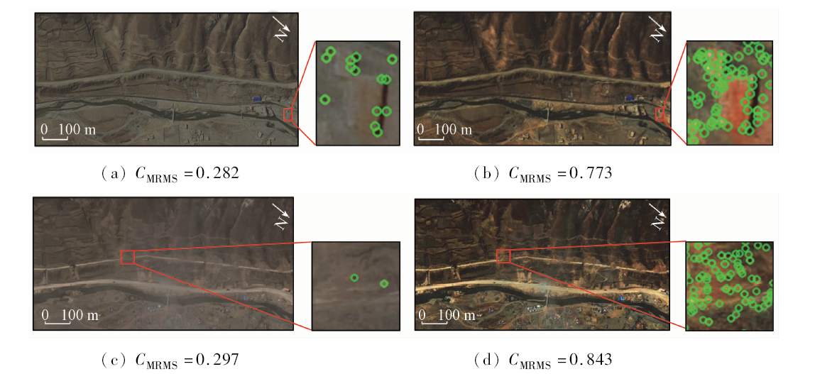
In view of the defects of the existing road obstacle detection methods, such as requirement for high registration accuracy, influence by imaging conditions , low-level automation and the need for professional operation, this paper proposes a road obstacle detection method based on reverse feature matching and accessibility evaluation method. On the basis of SIFT feature extraction algorithm, this method detects obstacles by acquiring the set of feature points that are not matched in the road buffer area of the disaster image, then obtains the distribution range and shape of obstacles by using a variety of sub-point region growing algorithms, and finally evaluates the road accessibility by overlapping analysis with road vector data. The experimental results show that this method can effectively extract the position information and shape information of obstacles.

Key wordshigh-resolution remote sensing image    obstacle detection    SIFT    region growth    accessibility
收稿日期: 2019-06-28      出版日期: 2020-06-18
:  TP79  
基金资助:高分辨率对地观测系统重大专项项目“**重点区遥感综合调查及关键技术与标准研究”资助(1204-120402)
通讯作者: 戚浩平
作者简介: 康晋洁(1995-),女,硕士研究生,主要研究方向为遥感影像目标提取与分析。Email: 317540589@qq.com。
引用本文:   
康晋洁, 戚浩平, 杨清华, 陈华. 道路通行障碍物遥感检测与通过性评价[J]. 国土资源遥感, 2020, 32(2): 94-102.
Jinjie KANG, Haoping QI, Qinghua YANG, Hua CHEN. Study of remote sensing detection method for road obstacle and accessibility evaluation. Remote Sensing for Land & Resources, 2020, 32(2): 94-102.
链接本文:  
https://www.gtzyyg.com/CN/10.6046/gtzyyg.2020.02.13      或      https://www.gtzyyg.com/CN/Y2020/V32/I2/94
Fig.1  影像对比度对特征点检测的影响
Fig.2  障碍物特征点筛选示意图
Fig.3  障碍物特征点分组
Fig.4  相同障碍物两侧特征点识别归并
Fig.5  提取标准道路样本
Fig.6  标定障碍物候选点性质
标注 后侧点 前侧点
+1 与路面相似 与障碍物相似
-1 与障碍物相似 与路面相似
0 与路面相似 与路面相似
0 与障碍物相似 与障碍物相似
Tab.1  障碍物候选点的性质
情形 双边线 路中线 通过性
1 双侧相交 相交 完全封闭
2 单侧相交 相交 部分通行
3 单侧相交 不相交 畅通
4 不相交 相交 部分通行
5 不相交 不相交 畅通
Tab.2  通过性评价
Fig.7  灾后影像和障碍物分布
Fig.8  道路ROI内特征点
Fig.9  障碍物特征点集示例
Fig.10  障碍物候选点示例
编号 障碍物坐标点标记 是否需要合并
1 0
2 +1
3 0
4 +1
5 -1
6 0
7 0
8 +1
9 -1
10 +1
11 -1
12 +1
13 -1
14 0
15 0
Tab.3  候选点性质的标定结果
Fig.11  障碍物检测结果
编号 坐标 计算面积/m2 参考面积/m2 误差/%
(103,529) 7.75 6.75 14.8
(290,502) 23.75 27.75 -14.4
(697,447) 36.50 37.00 -1.4
(1 146,464) 33.75 40.25 -16.1
(1 280,481) 15.50 13.25 17.0
(1 366,494) 34.25 34.50 -0.7
(1 500,506) 20.25 22.00 -8.0
(1 691,526) 23.00 24.50 -6.1
(1 841,538) 39.50 41.25 -4.2
(599,621) 8.00 7.25 10.3
? (1 698,682) 0 0 0
Tab.4  障碍物提取结果
Fig.12  叠置分析
Fig.13  道路ROI内特征点
Fig.14  障碍物特征点筛选及分组
Fig.15  障碍物检测结果
编号 坐标 计算面积/m2 参考面积/m2 误差/%
(114,201) 103 107 -3.7
(82,43) 67 76 -11.8
Tab.5  障碍物的位置和面积信息
[1] 交通运输部.2018年交通运输行业发展统计公报[EB/OL].(2019-05-27)[2019-04-12]. http://www.chinahighway.com/article/63052.html.
Ministry of Transport.Development statistics bulletin of transport industry in 2018[EB/OL](2019-05-27)[2019-04-12]. http://www.chinahighway.com/article/63052.html.
[2] 沙明华. 山区公路事故多发点判别及安全设施设置研究[D]. 成都:西南交通大学, 2018.
Sha M H. Study on the setting of safety facilities for accident prone points in mountain area[D]. Chengdu:Southwest Jiaotong University, 2018.
[3] 朱长安, 李玉文, 廖炜, 等. 地震灾区公路隧道泥石流灾害分析及减灾对策[J]. 公路, 2016,61(12):245-251.
Zhu C A, Li Y W, Liao W, et al. Analysis of debris flow hazard of highway tunnel in earthquake-strike area and mitigation countermeasures[J]. Highway, 2016,61(12):245-251.
[4] 胡凯衡, 陈成, 李秀珍, 等. 地震区降雨作用下泥石流易发性动态评估[J]. 中国地质灾害与防治学报, 2018,29(2):1-8.
Hu K H, Chen C, Li X Z, et al. Dynamic assessment of debris-flow susceptibility under the influence of earthquake and rainfall events[J]. The Chinese Journal of Geological Hazard and Control, 2018,29(2):1-8.
[5] 陈晓利, 单新建, 张凌, 等. 地震诱发滑坡的快速评估方法研究:以2017年MS7.0级九寨沟地震为例[J]. 地学前缘, 2019,26(2):312-320.
Chen X L, Shan X J, Zhang L, et al. Study on the rapid evaluation method of earthquake induced landslides:Taking the Jiuzhaigou earthquake of MS7.0 in 2017 as an example[J]. Geoscience front, 2019,26(2):312-320.
[6] 马思远, 许冲. 2018年地震滑坡机理与评估研讨会概述[J]. 地震地质, 2018,40(3):718-719.
Ma S Y, Xu C. Summary of 2018 Symposium on Mechanism and Assessment of Earthquake Induced Landslides[J]. Seismology and Geology, 2018,40(3):718-719.
[7] 吴毅勇.南方地区道路塌陷的成因分析、预防及治理[J].江西建材, 2017(21): 176,180.
Wu Y Y. Cause analysis, prevention and treatment of road collapse in South China[J].Jiangxi Building Materials,2017(21): 176,180.
[8] 胡聿涵, 白玉川, 徐海珏. 近10年中国城市道路塌陷原因及防治对策分析[J]. 公路, 2016,61(9):130-135.
Hu Y H, Bai Y C, Xu H Y. Analysis of reasons for urban road collapse and prevention and control countermeasures in recent decade of China[J]. Highway, 2016,61(9):130-135.
[9] 陈岩岩, 魏涛. 地震诱发崩塌滚石的运动特性及防护研究[J].路基工程, 2017(6):48-53.
Chen Y Y, Wei T. Kinetic characteristics of rockfall induced by earthquake and the protective measures[J].Subgrade Engineering, 2017(6):48-53.
[10] 林镇. 公路边坡滚石灾害运动特征模拟及风险评估[D]. 福州:福州大学, 2015.
Lin Z. Simulation of motion characteristics and risk assessment of rockfall hazard on highway slope[D]. Fuzhou:Fuzhou University, 2015.
[11] 自然资源部.2018年全国地质灾害灾情及2019年地质灾害趋势预测[EB/OL].(2019-05-27)[2019-01-09]. http://www.legaldaily.com.cn/index/content/2019-01/09/content_.htm.
Ministry of Natural Resources.2018 national geological disaster situation and 2019 geological disaster trend prediction[EB/OL](2019-05-27)[2019-01-09]. http://www.legaldaily.com.cn/index/content/2019-01/09/content_.htm.
[12] 鲁学军, 范晓冰, 李柳柯, 等. 地质灾害群测群防系统设计与实现[J]. 测绘科学, 2017,42(3):152-157,163.
Lu X J, Fan X B, Li L K, et al. Design and implementation of mass monitoring and mass prevention system of geological hazard[J]. Science of Surveying and Mapping, 2017,42(3):152-157,163.
[13] 曹海翊, 高洪涛, 赵晨光. 我国陆地定量遥感卫星技术发展[J]. 航天器工程, 2018,27(4):1-9.
Cao H Y, Gao H Y, Zhao C G. Development of China land quantitative remote sensing satellite technology[J]. Spacecraft Engineering, 2018,27(4):1-9.
[14] 李器宇, 张拯宁, 张皓琳. 商业卫星遥感产业发展现状与趋势分析[J].卫星应用, 2018(12):56-59.
Li Q Y, Zhang Z N, Zhang H L. Analysis of development status and trend of commercial satellite remote sensing industry[J].Satellite Application, 2018(12):56-59.
[15] 郭晗. 高分五号、六号卫星正式投入使用[J].卫星应用, 2019(4):54-55.
Guo H. GF-5 and GF-6 satellites are officially put into use[J].Satellite Application, 2019(4):54-55.
[16] 袁益琴, 何国金, 江威, 等. 遥感视频卫星应用展望[J]. 国土资源遥感, 2018,30(3):1-8.doi: 10.6046/gtzyyg.2018.03.01.
Yuan Y Q, He G J, Jiang W, et al. Application of earth observation system of video satellite[J]. Remote sensing of land and resources, 2018,30(3):1-8.doi: 10.6046/gtzyyg.2018.03.01.
[17] 罗伦. 卫星遥感技术在公路交通领域的应用[J].卫星应用, 2017(8):48-50.
Luo L. Application of satellite remote sensing technology in the field of highway transportation[J].Satellite Application, 2017(8):48-50.
[18] 唐尧, 王立娟, 马国超, 等. 利用国产遥感卫星进行金沙江高位滑坡灾害灾情应急监测[J]. 遥感学报, 2019,23(2):252-261.
Tang Y, Wang L J, Ma G C, et al. Emergency monitoring of high-level landslide disasters in Jinsha River using domestic remote sensing satellites[J]. Journal of Remote Sensing, 2019,23(2):252-261.
[19] 李金香, 温和平, 常想德, 等. 基于多光谱遥感的新疆皮山6.5级地震灾情监测与分析[J]. 内陆地震, 2017,31(1):30-39.
Li J X, Wen H P, Chang X D, et al. Monitoring and analysis of Xinjiang Pishan earthquake with MS6.5 disaster damage using multi-spectral remote sensing[J]. Inland earthquake, 2017,31(1):30-39.
[20] 陈子翰, 窦爱霞, 王晓青, 等. 基于高分辨率影像的九寨沟7.0级地震道路震害评估[J]. 中国地震, 2017,33(4):590-601.
Chen Z H, Dou A X, Wang X Q, et al. Assessment of road seismic damage for the Jiuzhaigou MS7.0 earthquake based on high resolution image[J]. Earthquake Research in China, 2017,33(4):590-601.
[21] 杨羿, 刘瑞强, 李海崇, 等. 遥感技术在广东省丰顺县地质灾害详细调查中的应用[J]. 地质灾害与环境保护, 2019,30(1):84-91.
Yang Y, Liu R Q, Li H C, et al. The application of rs technique for detailed investigation of geological hazards in Fengshun Country of Guangdong Province[J]. Journal of Geological Hazards and Environment Preservation, 2019,30(1):84-91.
[22] Chen Z H, Dou A X. Road damage extraction from post-earthquake UAV images assisted by vector data [C]// The ISPRS Technical Commission III Midterm Symposium on Developments,Technologies and Applications in Remote Sensing.Beijing,ISPRS, 2018.
[23] 王鹏, 葛洁, 方峥, 等. 半自动面向对象高分遥感地灾目标提取方法[J]. 山地学报, 2018,36(4):654-659.
Wang P, Ge J, Fang Z, et al. Semi-automatic object-oriented geological disaster target extraction based on high-resolution remote sensing[J]. Mountain Research, 2018,36(4):654-659.
[24] 权鸿斌, 姚剑敏. 基于卷积神经网络的道路障碍物检测算法[J]. 有线电视技术, 2018,25(6):19-23.
Quan H B, Yao J M. Road obstacle detection algorithm based on convolutional neural network[J]. Cable TV Technology, 2018,25(6):19-23.
[25] 韩健楠, 孙增慧. 卫星遥感在滑坡识别中的应用[J]. 资源节约与环保, 2018,204(11):131.
Han J N, Sun Z H. Application of satellite remote sensing in landslide identification[J]. Resources Economization and Environmental Protection, 2018,204(11):131.
[26] 陈彦, 伏晨荣, 卢有春, 等. 基于SAR图像的道路损毁信息提取[J]. 电子科技大学学报, 2016,45(4):551-556.
Chen Y, Fu C R, Lu Y C, et al. Road damage information extraction based on high-resolution SAR imagery[J]. Journal of University of Electronic Science and Technology of China, 2016,45(4):551-556.
[27] 马昱肖, 戚浩平, 田馨, 等. 高分辨率航摄影像城市交通设施变化检测方法研究[J]. 测绘工程, 2018,27(11):66-70,80.
Ma Y X, Qi H P, Tian X, et al. Resarch on detecting change of urban traffic facilities with high resolution aerial images[J]. Engineering of Surveying and Mapping, 2018,27(11):66-70,80.
[28] Sghaier M O, Lepage R. Road damage detection from VHR remote sensing images based on multiscale texture analysis and dempster shafer theory [C]// IEEE International Geoscience and Remote Sensing Symposium(IGARSS).IEEE, 2015.
[29] 钟家强, 王润生. 一种基于线特征的道路网变化检测算法[J]. 遥感学报, 2007,11(1):27-32.
Zhong J Q, Wang R S. A road network change detection algorithm based on linear feature[J]. Journal of Remote Sensing, 2007,11(1):27-32.
[30] 张玺锐. 基于SAR图像的道路损毁信息提取方法研究[D]. 成都:电子科技大学, 2013.
Zhang X R. Method research of damaged road information extraction based on SAR images[D]. Chengdu:University of Electronic Science and Technology of China, 2013.
[31] 刘轩, 刘佳宾. 基于对比度受限自适应直方图均衡的乳腺图像增强[J]. 计算机工程与应用, 2008,44(10):173-175.
Liu X, Liu J B. Mammary image enhancement based on contrast limited adaptive histogram equalization[J]. Computer Engineering and Applications, 2008,44(10):173-175.
[32] 郭兴隆. 基于多指标与支持向量回归的道路监控图像质量检测方法[J]. 公路交通技术, 2018,34(6):123-127.
Guo X L. A detection method of road monitor image quality based on multi-index and support vector regression[J]. Technology of Highway and Transport, 2018,34(6):123-127.
[33] 交通运输部公路局. JTG B01-2014公路工程技术标准[S].北京: 人民交通出版社, 2015.
Highway Bureau of the Ministry of Transport. JTG B01-2014 Highway Engineering Technical Standard[S]. Beijing: People’s Communications Press, 2015.
[1] 薛白, 王懿哲, 刘书含, 岳明宇, 王艺颖, 赵世湖. 基于孪生注意力网络的高分辨率遥感影像变化检测[J]. 自然资源遥感, 2022, 34(1): 61-66.
[2] 胡苏李扬, 李辉, 顾延生, 黄咸雨, 张志麒, 汪迎春. 基于高分辨率遥感影像的神农架大九湖湿地土地利用类型变化及其驱动力分析——来自长时间尺度多源遥感信息的约束[J]. 国土资源遥感, 2021, 33(1): 221-230.
[3] 张萌生, 杨树文, 贾鑫, 臧丽日. 一种基于格网索引优化的遥感影像自动配准算法[J]. 国土资源遥感, 2021, 33(1): 123-128.
[4] 卫虹宇, 赵银娣, 董霁红. 基于改进RetinaNet的冷却塔目标检测[J]. 国土资源遥感, 2020, 32(4): 68-73.
[5] 薛白, 付钰莹, 崔成玲, 宋艳茹, 赵世湖. 多重约束条件下的不同遥感影像匹配方法[J]. 国土资源遥感, 2020, 32(3): 49-54.
[6] 吴同, 彭玲, 胡媛. 基于SU-RetinaNet的高分辨率遥感影像非正规垃圾堆检测[J]. 国土资源遥感, 2020, 32(3): 90-97.
[7] 叶发茂, 罗威, 苏燕飞, 赵旭青, 肖慧, 闵卫东. 卷积神经网络特征在遥感图像配准中的应用[J]. 国土资源遥感, 2019, 31(2): 32-37.
[8] 程滔, 李广泳, 毕凯. 顾及时点特征的水体提取成果空间修正方法[J]. 国土资源遥感, 2019, 31(2): 96-101.
[9] 李云帆, 谭德宝, 刘瑞, 邬建伟. 顾及建筑物屋顶结构的改进RANSAC点云分割算法[J]. 国土资源遥感, 2017, 29(4): 20-25.
[10] 岳梦雪, 秦昆, 张恩兵, 张晔, 曾诚. 基于数据场和密度聚类的高分辨率影像居民区提取[J]. 国土资源遥感, 2017, 29(3): 92-97.
[11] 苏腾飞, 张圣微, 李洪玉. 基于纹理特征与区域生长的高分辨率遥感影像分割算法[J]. 国土资源遥感, 2017, 29(2): 72-81.
[12] 杜守基, 邹峥嵘, 张云生, 张明磊. L0级机载三线阵影像连接点自动提取[J]. 国土资源遥感, 2017, 29(1): 65-70.
[13] 李迁, 甘拯, 支晓栋, 刘玥, 王建超, 金鼎坚. 无人机近红外传感器数据匹配方法[J]. 国土资源遥感, 2017, 29(1): 86-91.
[14] 邓曾, 李丹, 柯樱海, 吴燕晨, 李小娟, 宫辉力. 基于改进SVM算法的高分辨率遥感影像分类[J]. 国土资源遥感, 2016, 28(3): 12-18.
[15] 李孚煜, 叶发茂. 基于SIFT的遥感图像配准技术综述[J]. 国土资源遥感, 2016, 28(2): 14-20.
Viewed
Full text


Abstract

Cited

  Shared   
  Discussed   
京ICP备05055290号-2
版权所有 © 2015 《自然资源遥感》编辑部
地址:北京学院路31号中国国土资源航空物探遥感中心 邮编:100083
电话:010-62060291/62060292 E-mail:zrzyyg@163.com
本系统由北京玛格泰克科技发展有限公司设计开发