Remote sensing survey of land occupied and damaged by abandoned mines along the Yangtze River Economic Belt and research on ecological remediation countermeasures
Yaqiu YIN, Jinzhong YANG, Jie WANG, Na AN, Yun JIANG
China Aero Geophysical Survey and Remote Sensing Center for Natural Resources, Beijing 100083, China
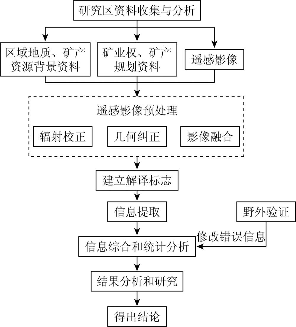
The Yangtze River Economic Belt is an important mineral resource base in China. Ecological and environmental problems caused by mineral resources exploitation are outstanding. In order to survey the situation of the land occupied and damaged by abandoned open-pit mines in this area and study the ecological remediation countermeasures, based on the domestic high spatial resolution remote sensing images acquired in 2016—2018 as the main data source, the authors used the techniques of remote sensing interpretation and information extraction to obtain the distribution information of the land occupied and damaged by abandoned open-pit mines in the range 50 km on the both sides of the main channel of the Yangtze River, which included Jinsha River in Sichuan and Yunnan Province and Yangtze River from Yibin to the estuary and the main tributaries which included Minjiang River, Tuojiang River, Chishui River, Jialing River, Wujiang River, Qingjiang River, Xiangjiang River, Hanjing River and Ganjiang River in the Yangtze River Economic Belt, and the geological hazard and environmental pollution information related to mining in the range of 10 km on the both sides of the river. The results show that in the range of 5 km, 10 km, 30 km, and 50 km from the main stream, the areas of the land occupied and damaged by abandoned open-air mines are 4 655.14 hm2, 8 787.57 hm2, 12 207.59 hm2, 21 040.85 hm2 and 30 034.47 hm2 respectively, and that for tributaries are 5 080.04 hm2, 8 644.25 hm2, 12 345.53 hm2, 21 290.29 hm2 and 33 491.49 hm2 respectively. Based on the results of remote sensing survey, the authors analyzed the environment of the abandoned open-air mines in the range of 10 km on the both sides of the Yangtze River main channel and main tributaries. The results show that the main problem in the upper reaches of the Yangtze River is that geological disasters caused by open mining and environmental pollution caused by metal and chemical raw material mines in the middle and lower reaches of the Yangtze River are quite serious. Combined with the advanced technology of mine environmental restoration, the authors put forward the countermeasures of mine ecological environmental restoration. Methods of slope reduction, slope cutting and slope reinforcement can be adopted to eliminate the hidden danger of collapse. Different green technologies can be used to prevent soil erosion according to the slope size. Artificial barrier layer, artificial fertilizer and microbial methods can be used for soil improvement. Toxic heavy metals in soil can be degraded by tolerant plants and microorganisms. Constructed wetlands can be built for water ecological restoration. The survey results and suggestions presented in this paper would provide the scientific bases and important references for the local mining administration on the ecological environmental remediation of the abandoned open-pit mines.
殷亚秋, 杨金中, 汪洁, 安娜, 姜赟. 长江经济带废弃矿山占损土地遥感调查与生态修复对策[J]. 国土资源遥感, 2020, 32(2): 170-176.
Yaqiu YIN, Jinzhong YANG, Jie WANG, Na AN, Yun JIANG. Remote sensing survey of land occupied and damaged by abandoned mines along the Yangtze River Economic Belt and research on ecological remediation countermeasures. Remote Sensing for Land & Resources, 2020, 32(2): 170-176.
Zhu D C, Ren Y S, Xu H M, et al. The spatial-temporal differentiation of spatial spillover effect in Yangtze River Economic Belt[J]. Economic Geography, 2016,36(6):26-33.
[2]
肖庆文. 长江经济带生态补偿机制深化研究[J].科学发展, 2019(5):74-85.
Xiao Q W. Deep research on ecological compensation mechanism of the Yangtze River Economic Belt[J].Scientific Development, 2019(5):74-85.
Fan L, Wen X H, Zhang X. Serving the green coordinated development of the Yangtze River Economic Belt:The documentary of Sichuan Bureau’s innovation and implementation of geographical situation monitoring[J].China Surveying and Mapping, 2018(6):37-40.
[4]
殷缶, 梅深. 长江经济带发展上升为国家战略[J]. 水道港口, 2016,37(2):134.
Yin F, Mei S. The development of the Yangtze River Economic Belt has risen to the national strategy[J]. Journal of Waterway and Harbor, 2016,37(2):134.
Chen J B. Research on the scientific development of the Yangtze River Economic Belt serving the three gorges project from the perspective of regional economy[D]. Wuhan:Wuhan University, 2017.
Wu C Q, Huang L. The difficulties and approaches of green development in the Yangtze River Economic Belt[J].Nankai Journal(Philosophy,Literature and Social Science Edition), 2017(3):50-61.
Li X, Wu R N, Guo Z Q, et al. Analysis on the relationship between Yangtze River Economic Belt and forestry development[J].Forestry Economics, 2016(11):30-35.
Li G J. Adhere to the ecological priority,green development and advance the Yangtze River Economic Belt of the ecological environment protection work[J]. Environmental Protection, 2016,44(11):7-13.
[9]
周飞. 湖北长江经济带小城市发展研究[D]. 武汉:华中师范大学, 2014.
Zhou F. Research on the development of small cities in the Yangtze River Economic Zone of Hubei Province[D]. Wuhan:Central China Normal University, 2014.
Wang Y, Zhang Y N, Zhang X G.Forestry ecology in the report on the work of the goverment of the two Sessions in 2017[J]. Ningxia Forestry Communication, 2017(2):8-10.
Zhang Y H, Wang B Q, Hou H L. Research on the mining industry coordinated development of the Yangtze River Economic Belt[J]. China Mining Magazine, 2018,25(8):58-63.
Liu L, Gao J H, Yu D Q. Monitoring and analysis of mine land occupation in Hunan Province based on remote sensing[J]. Geospatial Information, 2019,17(1):41-46,11.
Guan Q C, Hao J M, Wang H L, et al. Evaluation of ecological sensitivity of mineral resources city under economic transformation[J]. Transactions of the Chinese Society of Agricultural Engineering, 2018,34(21):253-262,311.
Tang R B, Fu M C, Chen Y. Identification of ecological critical portion by controlling the diffusion of mining disturbance:A case of Daye City[J].Metal Mine, 2018(3):161-167.
Li G Z. Upgrading and reshaping of mine geological remediation mode from the perspective of green development[J]. Journal of China University of Mining and Technology(Social Sciences), 2019,21(3):92-104.
Zhang C, Lyu Y H, Yun W J, et al. Analysis on research progress of remote sensing monitoring of land consolidation[J]. Transactions of the Chinese Society of Agricultural Machinery, 2019,50(1):1-22.
Zha D P, Shen Z, Liu Z G, et al. Changes of ecological environment in the Dexing copper mine based on TM images[J]. Remote Sensing for Land and Resources, 2015,27(4):109-114.doi: 10.6046/gtzyyg.2015.04.17.
Yang J Z, Nie H F, Jing Q Q. Preliminary analysis of mine geo-environment status and existing problems in China[J]. Remote Sensing for Land and Resources, 2017,29(2):1-7.doi: 10.6046/gtzyyg.2017.02.01.
Chen S L, Bi Y L. Application of remote sensing technology to microbial reclamation[J]. Remote Sensing for Land and Resources, 2014,26(3):16-23.doi: 10.6046/gtzyyg.2014.03.03.
Liu H B. Slope stability problem and landslide control method in construction of geological hazard control project[J].West-China Exploration Engineering, 2015(8):5-7,9.
Luo X M, Wang L. Along the high and steep slope rock mass mechanism analysis and control measures of the collapse[J]. Shanxi Architecture, 2018,44(3):78-80.
Fu J T, Li G Y, Hu X T, et al. Research status and development tendency of vegetation effects to soil reinforcement and slope stabilization[J]. Journal of Engineering Geology, 2014,22(6):1135-1146.
doi: 10.13544/j.cnki.jeg.2014.06.018
 2020, Vol. 32