Please wait a minute...
 
国土资源遥感  2020, Vol. 32 Issue (2): 196-203    DOI: 10.6046/gtzyyg.2020.02.25
  技术应用 本期目录 | 过刊浏览 | 高级检索 |
岸线变迁对田湾核电站温排水影响遥感调查
石海岗1, 梁春利1(), 张建永1,2, 张春雷1, 程旭1
1.核工业航测遥感中心,石家庄 050002
2.东华理工大学,南昌 330013
Remote sensing survey of the influence of coastline changes on the thermal discharge in the vicinity of Tianwan Nuclear Power Station
Haigang SHI1, Chunli LIANG1(), Jianyong ZHANG1,2, Chunlei ZHANG1, Xu CHENG1
1. Airborne Survey and Remote Sensing Center of Nuclear Industry, Shijiazhuang, Shijiazhuang 050002, China
2. Donghua Polytechnic University,Nanchang 330013, China
全文: PDF(8313 KB)   HTML  
输出: BibTeX | EndNote (RIS)      
摘要 

以田湾核电站周边海域为主要研究对象,选取2组同一潮态下、不同时相的Landsat8数据,研究田湾核电站周边岸线变化及温排水热影响现象,综合分析核电站周边岸线变迁对附近海域水温分布与变化的影响。结果表明,田湾核电站周边海域岸线变化显著,岸线变迁影响温排水水域流场分布,对核电站温排水区域造成影响。遥感技术能够监测出核电站周边岸线变迁情况及其对温排水的影响情况,关注周边岸线变化情况对于核电站周边海域海温监测工作具有积极意义。

服务
把本文推荐给朋友
加入引用管理器
E-mail Alert
RSS
作者相关文章
石海岗
梁春利
张建永
张春雷
程旭
关键词 岸线变迁Landsat8核电站温排水温度反演遥感监测    
Abstract

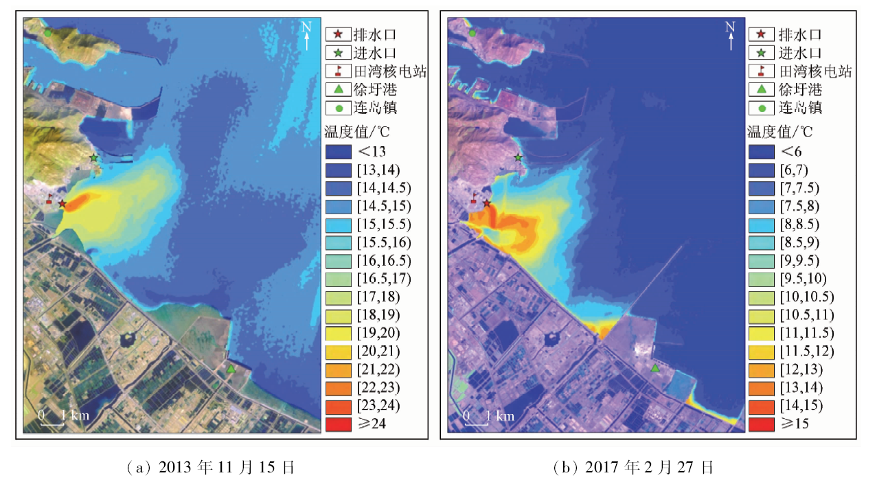
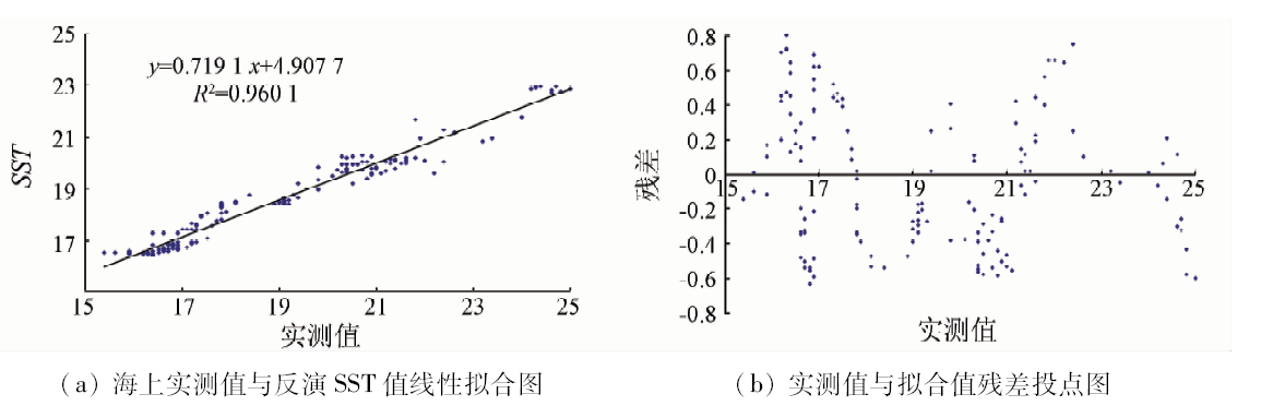
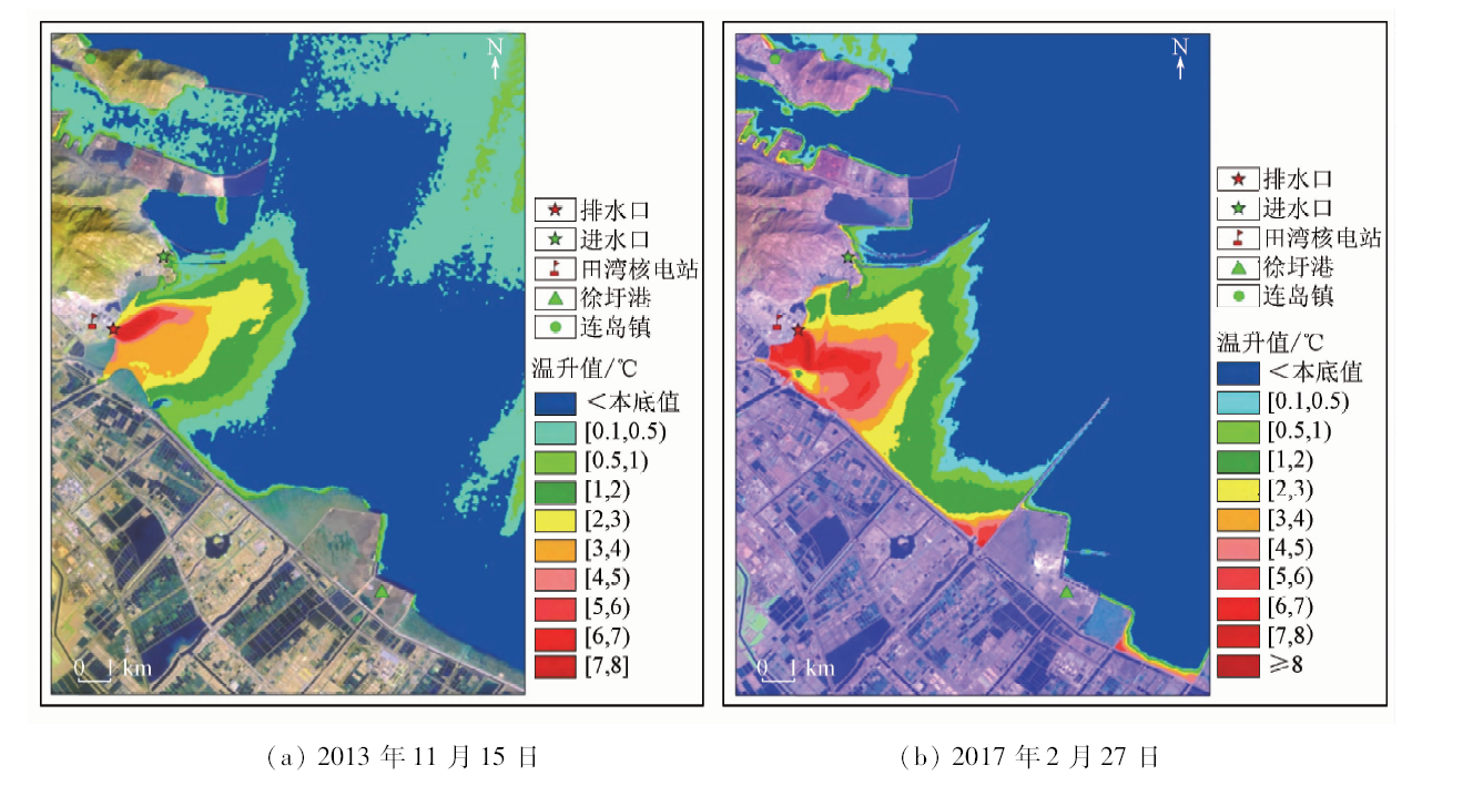
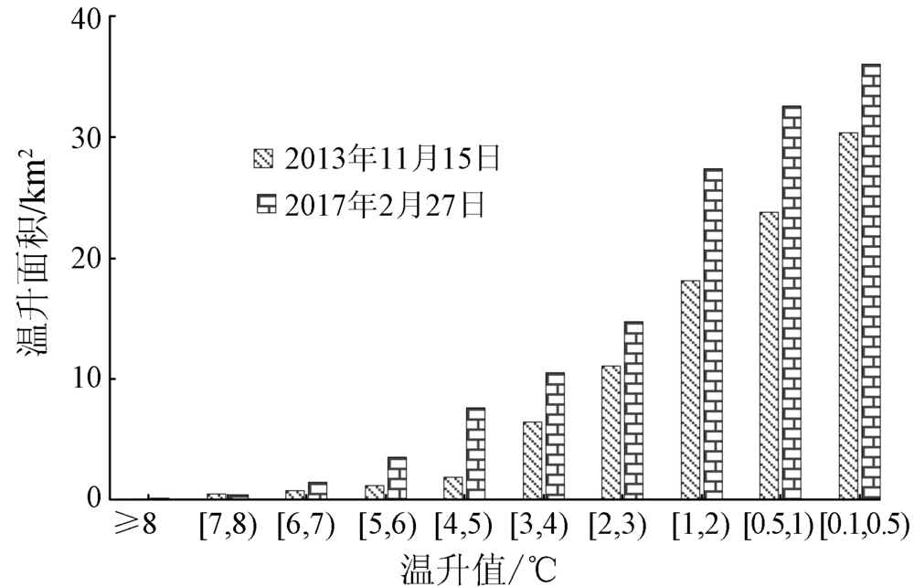
Based on the infrared data of the Landsat8 in similar tides and different time spans in the sea region near Tianwan nuclear plant,Lianyungang City,Jiangsu Province, on November 15,2013 and February 27,2017,the authors used remote sensing technology to study the thermal discharge of nuclear power plant and change along the coastal line. The relationship between the thermal discharge and change in the coastal line was analyzed. The results show that the construction of peripheral engineering of Tianwan nuclear power plant dramatically changed the coastline,which affected the size and distribution of the thermal discharge. Remote sensing technology can detect the change of coastal line near the nuclear power plant and its effect on thermal discharge distribution. It is important to monitor the change of coastline near the nuclear power plant for sea temperature monitoring.

Key wordscoastline changes    Landsat8    thermal discharge of nuclear power plant    temperature retrieving    remote sensing monitoring
收稿日期: 2018-11-09      出版日期: 2020-06-18
:  TP79  
基金资助:江苏核电站温排水调查项目“2017—2018年附近海域温排水遥感调查项目”(ASNJF17060-02);河北省人才工程培养经费资助科研项目“核电站温排水遥感监测技术研究”(A2017005010)
通讯作者: 梁春利
作者简介: 石海岗(1984-),男,硕士,工程师,主要从事遥感地质及应用方面工作,研究方向为遥感软件的应用及开发。Email: 383071766@qq.com。
引用本文:   
石海岗, 梁春利, 张建永, 张春雷, 程旭. 岸线变迁对田湾核电站温排水影响遥感调查[J]. 国土资源遥感, 2020, 32(2): 196-203.
Haigang SHI, Chunli LIANG, Jianyong ZHANG, Chunlei ZHANG, Xu CHENG. Remote sensing survey of the influence of coastline changes on the thermal discharge in the vicinity of Tianwan Nuclear Power Station. Remote Sensing for Land & Resources, 2020, 32(2): 196-203.
链接本文:  
https://www.gtzyyg.com/CN/10.6046/gtzyyg.2020.02.25      或      https://www.gtzyyg.com/CN/Y2020/V32/I2/196
Fig.1  田湾核电站周边岸线解译结果图
Fig.2  热红外温度场图
Fig.3  2013年11月15日海面实测点位图
Fig.4  2013年11月15日海上实测值与反演SST值线性拟合图和残差投点图
Fig.5  2013年11月15日MODIS热红外温度场图
Fig.6  2013年11月15日潮汐状态变化示意图
序号 Landsat8
反演结果
MODIS
反演结果
偏差
1 14.69 14.41 0.28
2 14.52 14.62 -0.10
3 14.76 14.87 -0.12
4 14.64 14.70 -0.05
5 14.55 14.55 0.00
6 14.63 14.46 0.17
7 14.37 14.56 -0.19
8 14.36 14.60 -0.24
9 14.40 14.63 -0.23
10 14.47 14.63 -0.16
11 15.15 15.79 -0.64
12 14.50 14.81 -0.31
13 15.18 14.60 0.58
14 14.87 14.78 0.09
15 14.37 14.43 -0.06
16 16.33 15.20 1.13
17 15.06 16.11 -1.05
18 14.40 14.70 -0.30
19 14.23 14.45 -0.22
20 14.27 14.33 -0.06
21 14.30 14.39 -0.09
22 14.30 14.45 -0.15
23 15.25 14.68 0.57
Tab.1  Landsat 8反演结果与MODIS反演结果对比表
Fig.7  2013年11月15日Landsat 8与MODIS反演结果数据拟合图
Fig.8  热影响编码图
Fig.9  不同时相热影响面积对比图(单位: km2)
[1] 於凡, 张永兴. 滨海核电站温排水对海洋生态系统影响的研究[J].辐射防护通讯, 2008(1):1-7.
Yu F, Zhang Y X. The review on the effects of thermal effluent from nuclear plants on the marine ecosystem[J].Radiation protection communication, 2008(1):1-7.
[2] 刘永叶, 陈晓秋. 核电厂温排水热影响研究的建议[J]. 辐射防护通讯, 2011,31(6):20-23.
Liu Y Y, Chen X Q. Suggestion of the study on thermal impact of thermal discharge from NPPs[J]. Radiation protection communication, 2011,31(6):20-23.
[3] 陈晓秋, 商照荣. 核电厂环境影响审查中的温排水问题[J].核安全, 2007(2):69-74.
Chen X Q, Shang Z R. The issue of thermal discharge in reviewing the environmental impacts report for nuclear power plant[J].Nuclear Saftey, 2007(2):46-50.
[4] 姜晟, 李俊龙, 李旭文. 核电站温排水遥感监测方法研究——以田湾核电站为例[J]. 中国环境监测, 2013,29(6):46-50.
Jiang S, Li J L, Li X W. A research on the remote sensing monitoring method with the thermal discharge of Tian-Wan nuclear power station[J]. Environmental Monitoring in China, 2013,29(6):46-50.
[5] 熊盛青. 国土资源遥感技术应用现状与发展趋势[J]. 国土资源遥感, 2002,51(1):1-5.doi: 10.6046/gtzyyg.2002.01.01.
S Q.The application status and development trend of remote sensing technology in national land and resources[J].Remote Sensing for Land and Resources,2002,51(1):1-5.doi: 10.6046/gtzyyg.2002.01.01.
[6] 姚沛林. 滨海核电厂温排水的监测与实践[J]. 红外, 2013,34(11):43-48.
Yao P L. Monitoring of warm water discharged from coastal nuclear power station[J]. Infrared, 2013,34(11):43-48.
[7] 王冠琳, 熊学军. 田湾海域温排水分布及变化规律分析[J]. 海洋科学进展, 2013,31(1):46-50.
Wang G L, Xiong X J. Distribution and variation of warm water discharge in the coasalt area of Tianwan[J]. Advances in Marine Science, 2013,31(1):46-50.
[8] 孙恋君, 王凤英, 朱晓翔. 田湾核电站温排水环境影响遥感调查[J]. 中国辐射卫生, 2011,20(3):330-332.
Sun L J, Wang F Y, Zhu X X. Remote sensing investigation on environmental impact of thermal discharge of Tianwan nuclear power station[J]. Chinese Journal of Radiological Health, 2011,20(3):330-332.
[9] 山东海阳核电项目3、4号机组温排水、液态流出物数值模拟补充计算分析报告[R]. 中国水利水电科学研究院, 2015,12:15-57.
Supplementary calculation and analysis report on numerical simulation of thermal discharge and liquid effluent for No.3 and No.4 nuclear power units of Haiyang nuclear power project in Shandong Province[R]. China Institute of Water Resources and Hydropower Research, 2015,12:15-57.
[10] 初庆伟, 张洪群, 吴业炜, 等, Landsat8卫星数据应用探讨[J]. 遥感信息, 2013,28(4):110-114.
Chu Q W, Zhang H Q, Wu Y W, et al. Application research of Landsat8[J]. Remote Sensing Information, 2013,28(4):110-114.
[11] 陈瀚阅, 朱利, 李家国, 等. 基于Landsat8数据的2种海表温度反演单窗算法对比——以红沿河核电基地海域为例[J]. 国土资源遥感, 2018,30(1):45-53.doi: 10.6046/gtzyyg.2008.01.07.
Chen H Y, Zhu L, Li J G, et al. A Comparison of two mono-window algorithm for retrieving sea surface temperature from Landsat8 data in coastal water of Hongyan River nuclear power station[J]. Journal of Geomatics, 2018,30(1):45-53.doi: 10.6046/gtzyyg.2008.01.07.
[12] Rozenstein. Derivation of land surface temperature for Landsat8 TIRS using a split window algorithm[J]. Sensors, 2014,14:5768-5780.
[13] Barsi J A, Barker J L, Schott J R. An atmospheric correction parameter calculator for a single thermal band earth-sensing instrument[J]. IGARSS03, 2003,5:3014-3016.
[14] Barsi J A, Schott J R, Palluconi F D, et al.Validation of a web-based atmospheric correction tool for single thermal band instruments[Z]. Earth Observing Systems X, 2005,5882:1-6.
[15] 刘玉洁, 杨忠东, 等. MODIS遥感信息处理原理与算法[M]. 北京: 科学出版社, 2001: 287-297.
Liu Y J, Yang Z D, et al. Processing principle and algorithm of MODIS remote sensing information[M]. Beijing: Science Press, 2001: 287-297.
[16] Otis B B, Peter J M,et al.Modis infrared sea surface temperature algorithm theoretical basis document[EB/OL].[2004-5-6]. http://modis.gsfc.nasa.gov/data/dataprod/dataproducts.php?MOD_NUMBER=28.
[17] 刘恒. 多传感器卫星海表温度数据的验证与交叉比较[D]. 青岛:中国海洋大学, 2008: 1-12.
Liu H. Verification and cross-comparison of multi-sensor satellite sea surface temperature data[D]. Qingdao:China Ocean University, 2008: 1-12.
[18] 田国良. 热红外遥感[M]. 北京: 电子工业出版社, 2006: 7-10.
Tian G L. Thermal infrared remote sensing[M]. Beijing: Electronic Industry Press, 2006: 7-10.
[1] 吕品, 熊丽媛, 徐争强, 周学铖. 基于FME的矿山遥感监测矢量数据图属一致性检查方法[J]. 自然资源遥感, 2022, 34(1): 293-298.
[2] 陈栋, 姚维岭. 基于ArcPy与定制ArcToolbox的矿山新增图斑自动编号及方法改进[J]. 国土资源遥感, 2021, 33(2): 262-269.
[3] 仇一帆, 柴登峰. 无人工标注数据的Landsat影像云检测深度学习方法[J]. 国土资源遥感, 2021, 33(1): 102-107.
[4] 王琳, 谢洪波, 文广超, 杨运航. 基于Landsat8的含蓝藻湖泊水体信息提取方法研究[J]. 国土资源遥感, 2020, 32(4): 130-136.
[5] 蔡耀通, 刘书彤, 林辉, 张猛. 基于多源遥感数据的CNN水稻提取研究[J]. 国土资源遥感, 2020, 32(4): 97-104.
[6] 汪洁, 刘小杨, 杨金中, 周英杰, 安娜, 王志晖. 基于国产高空间分辨率卫星数据的浙江省矿山环境恢复治理典型模式分析[J]. 国土资源遥感, 2020, 32(3): 216-221.
[7] 刁明光, 刘文静, 李静, 刘芳, 王彦佐. 矿山遥感监测矢量成果数据动态变化检测方法[J]. 国土资源遥感, 2020, 32(3): 240-246.
[8] 冯力力, 江利明, 柳林, 孙亚飞. 新疆克拉牙依拉克冰川变化(1973—2016)主被动遥感监测分析[J]. 国土资源遥感, 2020, 32(2): 162-169.
[9] 刘晰, 郝利娜, 杨显华, 黄洁, 张志, 杨武年. 矿山遥感监测指标快速统计方法研究与实现[J]. 国土资源遥感, 2020, 32(2): 259-265.
[10] 汪洁, 殷亚秋, 于航, 蒋存浩, 万语. 基于RS和GIS的浙江省矿山地质环境遥感监测[J]. 国土资源遥感, 2020, 32(1): 232-236.
[11] 赵玉灵, 杨金中, 殷亚秋, 赵航, 何金宝, 张汉. 海南岛东部滨海锆钛砂矿开发状况遥感监测与生态恢复治理对策研究[J]. 国土资源遥感, 2019, 31(4): 143-150.
[12] 吴海平, 黄世存. 基于深度学习的新增建设用地信息提取试验研究——全国土地利用遥感监测工程创新探索[J]. 国土资源遥感, 2019, 31(4): 159-166.
[13] 刘畅, 杨康, 程亮, 李满春, 郭紫燕. Landsat8不透水面遥感信息提取方法对比[J]. 国土资源遥感, 2019, 31(3): 148-156.
[14] 王大钊, 王思梦, 黄昌. Sentinel-2和Landsat8影像的四种常用水体指数地表水体提取对比[J]. 国土资源遥感, 2019, 31(3): 157-165.
[15] 刘文雅, 邓孺孺, 梁业恒, 吴仪, 刘永明. 基于辐射传输模型的巢湖叶绿素a浓度反演[J]. 国土资源遥感, 2019, 31(2): 102-110.
Viewed
Full text


Abstract

Cited

  Shared   
  Discussed   
京ICP备05055290号-2
版权所有 © 2015 《自然资源遥感》编辑部
地址:北京学院路31号中国国土资源航空物探遥感中心 邮编:100083
电话:010-62060291/62060292 E-mail:zrzyyg@163.com
本系统由北京玛格泰克科技发展有限公司设计开发