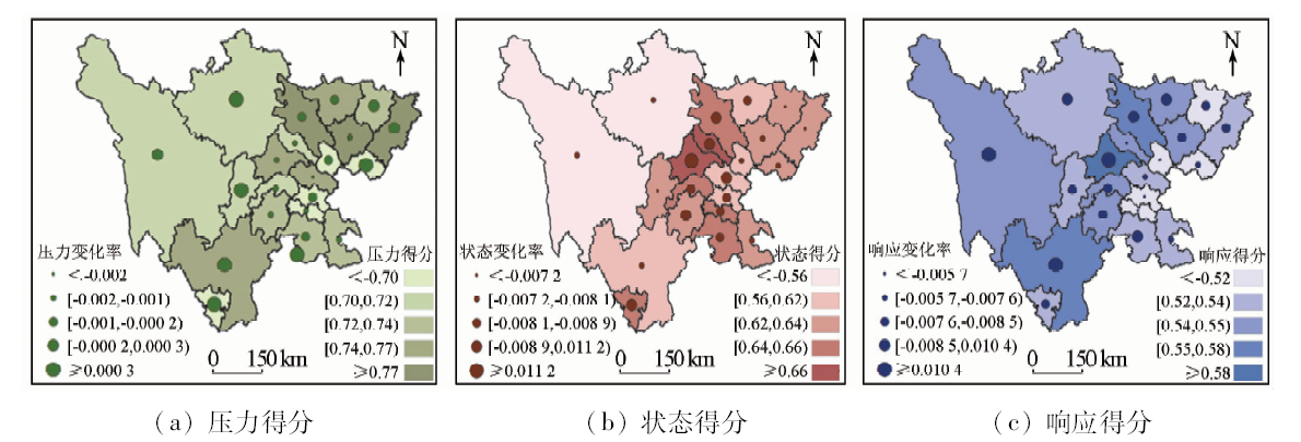
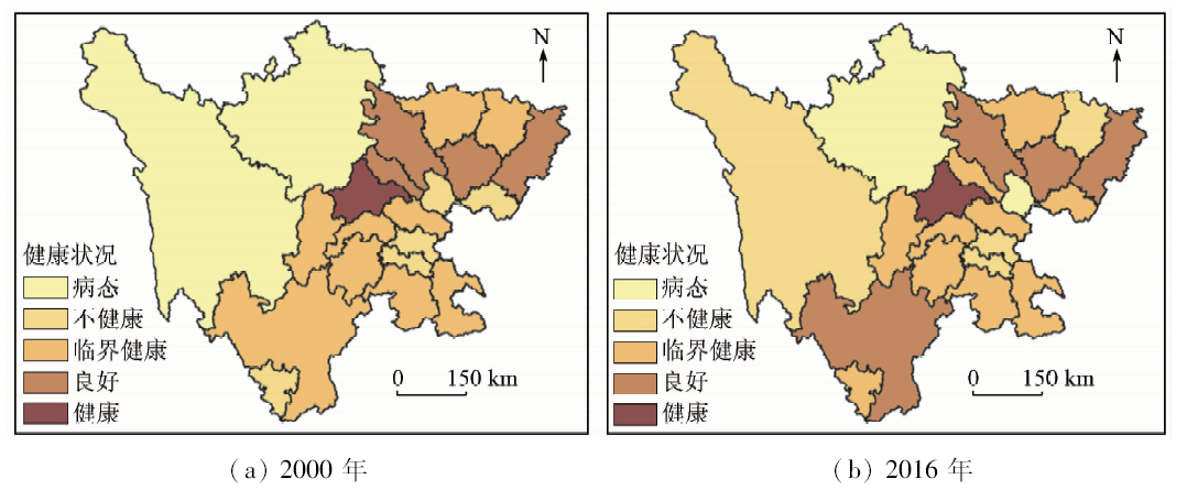
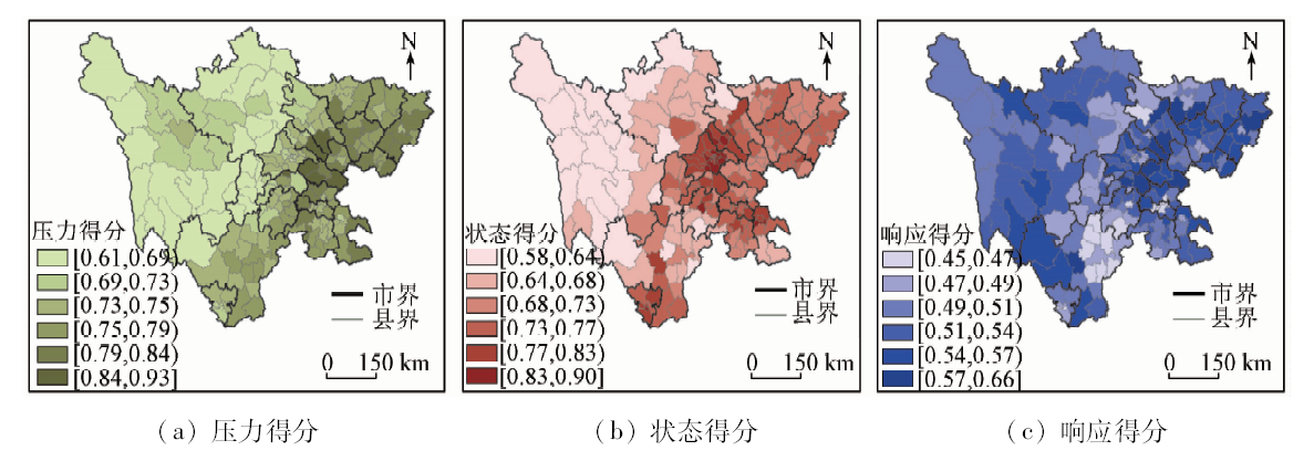
A great many ecological and environmental problems have been caused in the course of rapid economic development and urbanization in Sichuan Province. Evaluating ecosystem health condition is of significant importance for regional sustainable development. Based on relevant city-level data in social, economic, agricultural and ecological aspects from 2000 to 2016 as well as county-level data obtained through the downscaling model, the authors built the pressure-status-response model to make comprehensive evaluation and analysis of ecosystem health of studied regions in Sichuan Province on city-level and county-level scales. The results show that the overall score of ecosystem health in Sichuan increased from 0.610 to 0.687 in 2000—2016, but the spatial distribution shows that the eastern part of Sichuan was better than the western part. The development between studied regions is extremely unbalanced. Chengdu had outstanding advantages in comparison other regions. The results of ecosystem health assessment in each county shows that 27.9% of the total counties are “unhealthy” and “sick”, while about half of the counties are above the “normal” level. The counties whose evaluation results are “sick” are mainly concentrated in Garze and Aba prefectures. The ecological health status in northwest Sichuan deserves much more attention.
徐洲洋. 基于PSR模型的四川生态系统健康时空动态研究[J]. 国土资源遥感, 2020, 32(2): 251-258.
Zhouyang XU. Spatial-temporal dynamics of ecosystem health in Sichuan Province based on PSR model. Remote Sensing for Land & Resources, 2020, 32(2): 251-258.
Wang Z, Tang L, Qiu Q, et al. Assessment of regional ecosystem health——A case study of the golden triangle of southern Fujian Province,China[J]. International Journal of Environmental Research and Public Health, 2018,15(4):802.
Sun Y, Zhou Y M, Zhang Q W, et al. Ecosystem health:Theory/concept and evaluation method[J]. Progress in Geosciences, 2011,26(8):887-896.
[3]
Zhang F, Zhang J, Wu R, et al. Ecosystem health assessment based on DPSIRM framework and health distance model in Nansi Lake,China[J]. Stochastic Environmental Research and Risk Assessment, 2016,30(4):1235-1247.
[4]
Rapport D J. What constitutes ecosystem health?[J]. Perspectives in Biology and Medicine, 2015,33(1):120-132.
doi: 10.1353/pbm.1990.0004
[5]
Zhang J Y, Wang L C. Assessment of water resource security in Chongqing City of China:What has been done and what remains to be done?[J]. Natural Hazards, 2015,75(3):2751-2772.
[6]
Jia H C, Cao C X, Ma G R, et al. Assessment of wetland ecosystem health in the source region of Yangtze,Yellow and Yalu Tsangpo Rivers of Qinghai Province[J]. Wetland Science, 2011,9(3):209-217.
[7]
Jϕrgensen S E, Constanza R, Xu F L.Handbook of Ecological Indicators for Assessment of Ecosystem Health[M]. London: CRC Press, 2005.
[8]
Xu F L, Lam K C, Chen Y Q, et al. Restorating marine coastal ecosystem health as a new goad for integrated catchment management in Tolo Harbour,Hong Kong,China[J]. Chinese Journal of Population Resources and Environment, 2004,2(2):11-19.
[9]
Su S, Zhang Z, Xiao R, et al. Geospatial assessment of agroecosystem health:Development of an integrated index based on catastrophe theory[J]. Stochastic Environmental Research and Risk Assessment, 2012,26(3):321-334.
[10]
Murray C N, Avogadro A. Effect of a long-term release of plutonium and americium into an estuarine-coastal sea ecosystem-I.Development of an assessment methodology[J]. Health Physics, 1979,36(5):573-585.
[11]
Spiegel J M, Bonet M, Yassi A, et al. Developing ecosystem health indicators in Centro Habana:A community-based approach[J]. 2001,7(1):15-26.
Yi W Y, Su W C. Evaluation of ecological security in the Wujiang River basin using remote sensing and GIS technologies[J]. Carsologica Sinica, 2014,33(3):308-318.
Wang Y, Qian W Y, Zhu L. Zoning assessment of ecosystem health based on GIS in Hongze Lake[J]. Journal of Water Resources and Water Engineering, 2011,22(4):124-127.
Chen P. Ecological health assessment at the landscape scale based on RS and GIS:A case study from the new district of a bay-type city[J].Acta Scientiae Circumstantiae, 2007(10):1744-1752.
[16]
Maga$\bar{n}$a P, López-Ruiz,Lira A, et al. A public, open Western Europe database of shoreline undulations based on imagery[J]. Applied Geography, 2014,55:278-291.
[17]
Frashure K M, Bowen R E, Chen R F. An integrative management protocol for connecting human priorities with ecosystem health in the Neponset River Estuary[J].Ocean and Coastal Management, 2012(69):255-264.
[18]
Dereynier Y L, Levin P S, Shoji N L. Bringing stakeholders,scientists,and managers together through an integrated ecosystem assessment process[J]. Marine Policy, 2010,34(3):534-540.
doi: 10.1016/j.marpol.2009.10.010
[19]
Pirrone N, Trombino G, Cinnirella S, et al. The driver-pressure-state-impact-response (DPSIR) approach for integrated catchment-coastal zone management:Preliminary application to the Po catchment-Adriatic Sea coastal zone system[J]. Regional Environmental Change, 2005,5(2-3):111-137.
doi: 10.1007/s10113-004-0092-9
[20]
Liang P, Du L, Yue G. Ecological security assessment of Beijing based on PSR model[J]. Procedia Environmental Sciences, 2010,2(2):832-841.
doi: 10.1016/j.proenv.2010.10.094
[21]
Ye H, Ma Y, Dong L. Land ecological security assessment for Bai Autonomous Prefecture of Dali based using PSR model-with data in 2009 as case[J]. Energy Procedia, 2011,5(22):2172-2177.
doi: 10.1016/j.egypro.2011.03.375
Shi Y L, Yang D F, Wang R S, et al. Ecosystem health assessment based on PSR model:A case study of Dafeng City in Jiangsu Province[J].Environmental Science and Technology, 2008(2):120-123.
[23]
Jin Y, Lu Z, Tan F, et al. Assessment of ecological carrying capacity on the typical resources-based cities:A case study of Tangshan City[J]. Acta Ecologica Sinica, 2015,35(14).
Jan Y H, Zhao J, Nan Z R, et al. The application of entropy-right method to the study of ecological security evaluation of grassland:A case study at the ecological security evaluation of grassland to pastoral area of Gansu[J]. Journal of Arid Land Resources and Environment, 2007,21(1):17-21.
[25]
Mayor M, López A J. Spatial shift-share analysis versus spatial filtering:An application to Spanish employment data[J]. Empirical Economics, 2008,34(1):123-142.
doi: 10.1007/s00181-007-0167-9
Fang L Y, Huang Z F, Chen W D. Spatial evolution of county economy in Anhui Province during 2001—2010[J]. Progress in Geography, 2013,32(5):831-839.
doi: 10.11820/dlkxjz.2013.05.014
[27]
Zhou L, Zhou C, Yang F, et al. Spatio-temporal evolution and the influencing factors of PM_(2.5) in China between 2000 and 2011[J]. Acta Geographica Sinica, 2017,72(11):2079-2092.
doi: 10.11821/dlxb201711012
Hou G L, Zhang H Y, Guo D, et al. Spatial-temporal variation of NDVI in the growing season and its sensitivity to climatic factors in Changbai Mountains[J]. Progress in Geography, 2012,31(3):285-292.
doi: 10.11820/dlkxjz.2012.03.003
Wang J C. The construction and application of economic gravity model in Chengdu economic zone from the perspective of spatial economics[D]. Chengdu:Southwest Jiaotong University, 2018.
[30]
Raskie J. Geospatial analysis of fisheries to improve federal enforcement[D]. Durham:Duke Vniversity, 2013.
He X, Jiang G H, Zhang R J, et al. Temporal and spatial variation of land ecosystem health based on the pressure-state-response model:A case study of Pinggu District,Beijing[J]. Journal of Natural Resources, 2015,30(12):2057-2068.
Hong H K, Liao H P, Wei C F, et al. Health assessment of a land use system used in the ecologically sensitive area of the Three Gorges reservoir area,based on the improved TOPSIS Method[J]. Acta Ecologica Sinica, 2015,35(24):8016-8027.
[33]
Wang L, Cao L, Deng X, et al. Changes in aridity index and reference evapotranspiration over the central and eastern Tibetan Plateau in China during 1960—2012[J]. Quaternary International, 2014,349:280-286.
doi: 10.1016/j.quaint.2014.07.030
[34]
Vuuren D P V, Smith S J, Riahi K. Downscaling socioeconomic and emissions scenarios for global environmental change research:A review[J]. Wiley Interdisciplinary Reviews Climate Change, 2010,1(3):393-404.
doi: 10.1002/wcc.50
 2020, Vol. 32