Please wait a minute...
 
国土资源遥感  2020, Vol. 32 Issue (3): 114-120    DOI: 10.6046/gtzyyg.2020.03.15
  技术应用 本期目录 | 过刊浏览 | 高级检索 |
基于多源SAR数据唐山城区活动断裂微小差异形变探测
张玲(), 刘斌, 葛大庆, 郭小方
中国自然资源航空物探遥感中心,北京 100083
Detecting tiny differential deformation of Tangshan urban active fault using multi-source SAR data
ZHANG Ling(), LIU Bin, GE Daqing, GUO Xiaofang
China Aero Geophysical Survey and Remote Sensing Center for Natural Resources, Beijing 100083, China
全文: PDF(4024 KB)   HTML  
输出: BibTeX | EndNote (RIS)      
摘要 

活动断裂活动特征存在明显的时空分异性,需要长期有效地进行监测。合成孔径雷达干涉测量(interferometric synthetic aperture Radar,InSAR)技术是近些年来地表形变调查监测的主要技术手段之一,具有覆盖范围广、信息获取效率高、成本低等优势。以InSAR技术为手段,采用相干目标点长时间序列分析方法,利用RADARSAT-2卫星Wide模式30 m空间分辨率和TerraSAR-X卫星Strip模式3 m空间分辨率这2种雷达数据,开展了唐山市城区主要活动断裂两侧微小差异性形变探测的应用研究。结果显示,城区内唐山—古冶断裂较为明显,最大的差异量在2 mm/a。以RADARSAT-2卫星C波段中等分辨率雷达数据为数据源的形变结果可以清晰地呈现出活动断裂两侧差异性形变; 而TerraSAR-X卫星X波段数据雷达波长较短,受地表覆被变化影响较大,且活动断裂的变化相对于该量值较小,较难从地表形变中分离出断裂两侧的差异性形变。

服务
把本文推荐给朋友
加入引用管理器
E-mail Alert
RSS
作者相关文章
张玲
刘斌
葛大庆
郭小方
关键词 InSAR活动断裂差异性形变微小形变    
Abstract

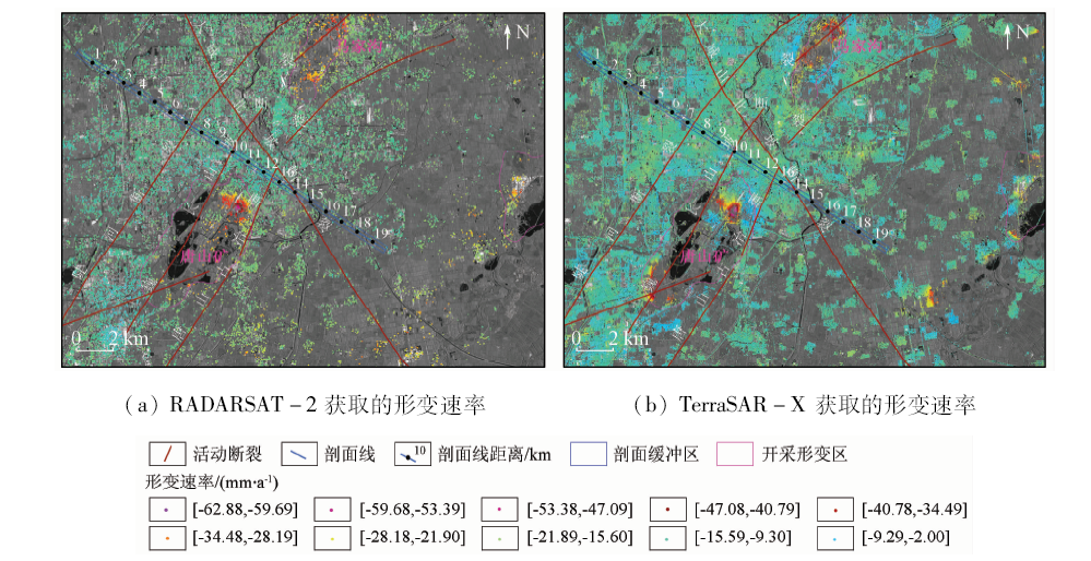
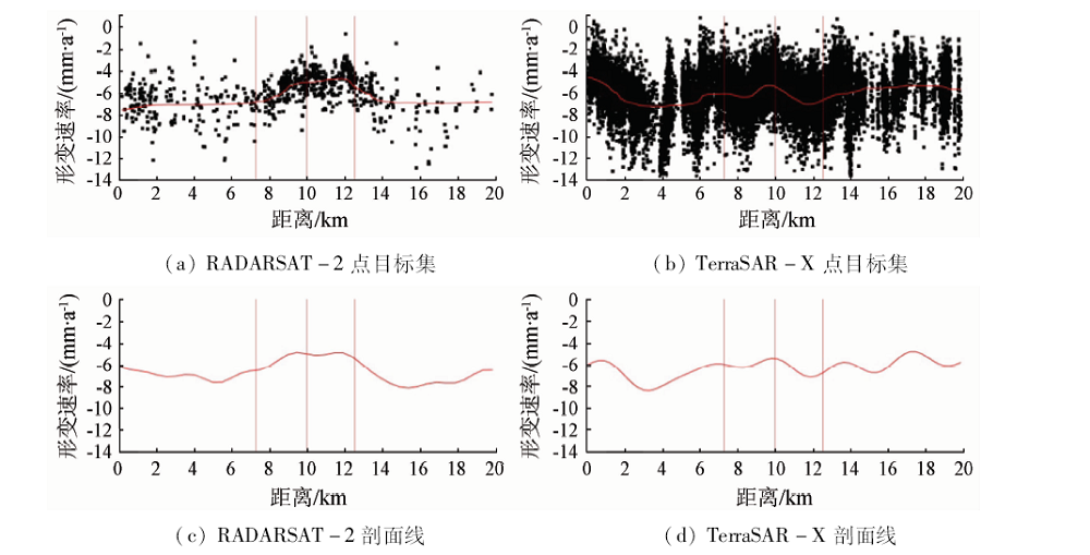
The active faults deformation, with distinct temporal and spatial variations, requires long-term and effective monitoring. InSAR (interferometry synthetic aperture Radar), with the advantages of high efficiency, wide coverage and low cost, is one of the main technical means for ground surface deformation survey in recent years. In this paper, the small differential deformation of the main active faults in Tangshan urban area was monitored by the interferometric point target analysis. Two kinds of radar data were used: the Wide strip mode of RADARSAT-2 C-band with 30m spatial resolution and the Strip mode of TerraSAR-X X-band with 3 m spatial resolution. The results show that the differential deformation of Tangshan-Guye active fault is obvious with the maximum differential velocity of 2 mm/a. In this case, the deformation results from RADARSAT-2 C-band medium resolution data can clearly show the tiny differential deformation between the two sides of the active faults. However, TerraSAR-X X-band data, with shorter wavelength, is more obviously affected by the change of surface cover. Compared with this deformation, the vertical differential deformation between the two sides of active faults is too small to be separated from the TerraSAR results.

Key wordsInSAR    active fault    differential deformation    tiny surface deformation
收稿日期: 2019-07-26      出版日期: 2020-10-09
:  P237  
基金资助:中国地质调查局项目“京津冀地区地面沉降地裂缝调查及地质环境监测”(DD20160237);“全国地面沉降遥感地质调查与监测”(DD20190513)
作者简介: 张玲(1982-),女,硕士,高级工程师。主要从事InSAR地表形变监测理论与应用研究。 Email: zling127@qq.com
引用本文:   
张玲, 刘斌, 葛大庆, 郭小方. 基于多源SAR数据唐山城区活动断裂微小差异形变探测[J]. 国土资源遥感, 2020, 32(3): 114-120.
ZHANG Ling, LIU Bin, GE Daqing, GUO Xiaofang. Detecting tiny differential deformation of Tangshan urban active fault using multi-source SAR data. Remote Sensing for Land & Resources, 2020, 32(3): 114-120.
链接本文:  
https://www.gtzyyg.com/CN/10.6046/gtzyyg.2020.03.15      或      https://www.gtzyyg.com/CN/Y2020/V32/I3/114
测量值 精度(1σ)
平均形变速率(LOS)/(mm·a-1) 1
单次差分测量(LOS)/mm 5
东向/m 6
北向/m 3
高程/m 1.5
Tab.1  InSAR典型测量值精度[7]
Fig.1  处理基本流程
编号 日期 编号 日期 编号 日期 编号 日期
1 2012/11/18 10 2013/11/13 19 2014/12/02 28 2016/03/26
2 2013/01/05 11 2013/12/07 20 2014/12/26 29 2016/04/19
3 2013/01/29 12 2014/02/17 21 2015/02/12 30 2016/05/13
4 2013/04/11 13 2014/04/06 22 2015/04/01 31 2016/06/06
5 2013/05/05 14 2014/04/30 23 2015/05/19 32 2016/06/30
6 2013/06/22 15 2014/08/04 24 2015/07/30 33 2016/08/17
7 2013/08/09 16 2014/08/28 25 2015/08/23 34 2016/09/10
8 2013/09/02 17 2014/09/21 26 2015/10/10 35 2016/10/28
9 2013/09/26 18 2014/11/08 27 2016/02/07
Tab.2  RADARSAT-2数据列表
编号 日期 编号 日期 编号 日期 编号 日期
1 2012/12/06 4 2013/04/28 7 2013/09/29 10 2013/12/04
2 2013/02/10 5 2013/06/11 8 2013/10/21 11 2013/12/26
3 2013/03/15 6 2013/08/27 9 2013/11/12
Tab.3  TerraSAR-X数据列表
Fig.2  干涉图像对组合时空基线
Fig.3  2013年唐山市主城区地面沉降速率
Fig.4  2013年不同剖面分析数据比较
Fig.5  2013—2016年研究区微小差异性形变
[1] Fialko Y. Interseismic strain accumulation and the earthquake potential on the southern San Andreas Fault system[J]. Nature, 2006,441(22):967-971.
[2] 屈春燕, 单新建, 张国宏, 等. 时序InSAR断层活动性观测研究进展及若干问题探讨[J]. 地震地质, 2014,36(3):731-748.
doi: 10.3969/j.issn.0253-4967.2014.03.015
Qu C Y, Shan X J, Zhang G H, et al. The research progress in measurement of fault activity by time series InSAR and discussion of related issues[J]. Seismology and Geology, 2014,36(3):731-748.
doi: 10.3969/j.issn.0253-4967.2014.03.015
[3] Zhang L, Cao D Y, Zhang J F, et al. Interseismic fault movement of Xianshuihe fault zone based on across-fault deformation data and InSAR[J].Pure and Applied Geophysics, 2019(176):649-667.
[4] 周海涛, 郭良迁, 张立成. 唐山断裂现代活动性研究[J]. 华北地震科学, 2009,27(3):17-22.
Zhou H T, Guo L Q, Zhang L C. Study on modern activity of Tangshan fault[J]. North China Earthquake Sciences, 2009,27(3):17-22.
[5] Ferretti A, Prati C, Rocca F. Permanent scatterers in SAR interferometry[J]. IEEE Transactions on Geoscience and Remote Sensing, 2001,39(1):1-20.
[6] Wemer C, Wegmiiller U, Strozzi T, et al. Interferometric point target analysis for deformation mapping[J].IEEE Transactions on Geoscience and Remote Sensing, 2003(7):4362-4364.
[7] Ferretti A, Tamburini A, Novali F, et al. Impact of high resolution radar imagery on reservoir monitoring[J]. Energy Procedia, 2011,(4):3465-3471.
doi: 10.1016/j.egypro.2011.02.272
[8] Berardino P, Fornaro G, Lanari R, et al. A new algorithm for surface deformation monitoring based on small baseline differential SAR interferograms[J]. IEEE Transactions on Geoscience and Remote Sensing, 2002,40(11):2375-2383.
doi: 10.1109/TGRS.2002.803792
[9] 邓起东. 城市活动断裂探测和地震危险性评价问题[J]. 地震地质, 2002,24(4):601-605.
Deng Q D. Exploration and Seismic hazard assessment of active faults in urban areas[J]. Seismology and Geology, 2002,24(4):601-605.
[10] 李传友, 汪一鹏, 王志才. 中国东部城市地区隐伏断裂上断点与最新活动时代关系的初步分析——以邢台、唐山地震区为例[J]. 地震地质, 2007,29(2):431-445.
Li C Y, Wang Y P, Wang Z C. Some analyses on the relation between the upper offset point and the latest activity times of buried faults in cities of eastern China:Taking the Xingtai and Tangshan earthquake regions as an example[J]. Seismology and Geology, 2007,29(2):431-445.
[11] 王景明, 王文秋, 苏幼坡. 唐山市区断裂活动与地质灾害[J]. 河北理工学院学报, 1998,20(1):75-83.
Wang J M, Wang W Q, Su Y P. The fracture activities and geological calamity in Tangshan City[J]. Journal of Hebei Institute of Technology, 1998,20(1):75-83.
[12] Liu K, Qu G S, Chen J Q, et al. Recurrence characteristics of major earthquakes in the Tangshan area,north China[J]. Acta Geologica Sinica-English Edition, 2013,87(1):254-271.
doi: 10.1111/1755-6724.12046
[1] 杨旺, 何毅, 张立峰, 王文辉, 陈有东, 陈毅. 甘肃金川矿区地表三维形变InSAR监测[J]. 自然资源遥感, 2022, 34(1): 177-188.
[2] 李梦梦, 范雪婷, 陈超, 李倩楠, 杨锦. 徐州矿区2016—2018年地面沉降监测与分析[J]. 自然资源遥感, 2021, 33(4): 43-54.
[3] 史珉, 宫辉力, 陈蓓蓓, 高明亮, 张舜康. Sentinel-1A京津冀平原区2016—2018年地面沉降InSAR监测[J]. 自然资源遥感, 2021, 33(4): 55-63.
[4] 沙永莲, 王晓文, 刘国祥, 张瑞, 张波. 基于SBAS InSAR的新疆哈密砂墩子煤田开采沉陷监测与反演[J]. 自然资源遥感, 2021, 33(3): 194-201.
[5] 张腾, 谢帅, 黄波, 范景辉, 陈建平, 童立强. 利用Sentinel-1和ALOS-2数据探测茂县中部活动滑坡[J]. 国土资源遥感, 2021, 33(2): 213-219.
[6] 何海英, 陈彩芬, 陈富龙, 唐攀攀. 张家口明长城景观廊道Sentinel-1影像SBAS形变监测示范研究[J]. 国土资源遥感, 2021, 33(1): 205-213.
[7] 于海若, 宫辉力, 陈蓓蓓, 周超凡. 新水情下利用InSAR-GRACE卫星的新兴风险预警与城市地下空间安全展望[J]. 国土资源遥感, 2020, 32(4): 16-22.
[8] 朱茂, 沈体雁, 黄松, 白书建, 葛春青, 胡琼. InSAR技术地铁沿线建筑物形变监测[J]. 国土资源遥感, 2019, 31(2): 196-203.
[9] 汪东, 来风兵, 陈孟禹, 陈蜀江, 黄铁成, 贾翔. 基于InSAR技术天山乌吐劲河谷同震形变遥感研究[J]. 国土资源遥感, 2019, 31(1): 187-194.
[10] 谢小平, 白毛伟, 陈芝聪, 柳伟波, 席书娜. 龙门山断裂带北东段活动断裂的遥感影像解译及构造活动性分析[J]. 国土资源遥感, 2019, 31(1): 237-246.
[11] 薛娟, 俞琳锋, 林起楠, 刘广, 黄华国. 基于Sentinel-1多时相InSAR影像的云南松切梢小蠹危害程度监测[J]. 国土资源遥感, 2018, 30(4): 108-114.
[12] 刘一霖, 张勤, 黄海军, 杨成生, 赵超英. 矿区地表大量级沉陷形变短基线集InSAR监测分析[J]. 国土资源遥感, 2017, 29(2): 144-151.
[13] 李曼, 葛大庆, 张玲, 刘斌, 郭小方, 王艳. 基于PSInSAR技术的曹妃甸新区地面沉降发育特征及其影响因素分析[J]. 国土资源遥感, 2016, 28(4): 119-126.
[14] 孙晓鹏, 鲁小丫, 文学虎, 甄艳, 王蕾. 基于SBAS-InSAR的成都平原地面沉降监测[J]. 国土资源遥感, 2016, 28(3): 123-129.
[15] 陈丹蕾, 刘国祥, 王晓文, 王蕾, 蒲慧龙. 基于DInSAR技术与断层自动剖分方法反演断层滑动参数[J]. 国土资源遥感, 2016, 28(3): 25-30.
Viewed
Full text


Abstract

Cited

  Shared   
  Discussed   
京ICP备05055290号-2
版权所有 © 2015 《自然资源遥感》编辑部
地址:北京学院路31号中国国土资源航空物探遥感中心 邮编:100083
电话:010-62060291/62060292 E-mail:zrzyyg@163.com
本系统由北京玛格泰克科技发展有限公司设计开发