Please wait a minute...
 
国土资源遥感  2020, Vol. 32 Issue (3): 143-148    DOI: 10.6046/gtzyyg.2020.03.19
  技术应用 本期目录 | 过刊浏览 | 高级检索 |
郑州市地面沉降时空演变规律研究
汪宝存1(), 朱琳1, 潘登2, 郭凌飞1, 彭鹏3
1.河南省地质矿产勘查开发局测绘地理信息院,郑州 450000
2.河南省地质环境监测院,郑州 450016
3.安徽省地质调查院,合肥 230001
Research on temporal and spatial evolution law of land subsidence in Zhengzhou
WANG Baocun1(), ZHU Lin1, PAN Deng2, GUO Lingfei1, PENG Peng3
1. Institute of Surveying, Mapping and Geoinformation of Henan Provincial Bureau of Geo-Exploration and Mineral Development,Zhengzhou 450000, China
2. Henan Geo-Environmental Monitoring Institute, Zhengzhou 450016, China,Zhengzhou 450000, China
3. Geological Survey of Anhui Province, Hefei 230001, China
全文: PDF(3624 KB)   HTML  
输出: BibTeX | EndNote (RIS)      
摘要 

为查明郑州市地面沉降演变规律,服务城市地面沉降防控工作,选用2007—2017年间合成孔径雷达(synthetic aperture Radar,SAR)数据,结合水准监测结果,获取了郑州市2007—2010年、2012—2013年、2013—2016年和2016—2017年4个时间段的地面沉降分布图,从时间和空间2个角度,分析了郑州市地面沉降演变规律; 利用地理信息系统(geographic information system,GIS)空间分析方法,研究了10 a间地面沉降与城中村演变之间的时空响应关系。研究结果表明,城中村是郑州市地面沉降演变的主导因素,即城中村超采地下水导致地面沉降; 城中村拆迁,地下水抽取减少导致地面沉降变缓甚至出现地面沉降抬升; 因拆迁导致流动人口迁移到远郊的城中村,形成新的流动人口、产业聚集区,进而形成了新的地面沉降区。

服务
把本文推荐给朋友
加入引用管理器
E-mail Alert
RSS
作者相关文章
汪宝存
朱琳
潘登
郭凌飞
彭鹏
关键词 SAR地面沉降演变规律城中村    
Abstract

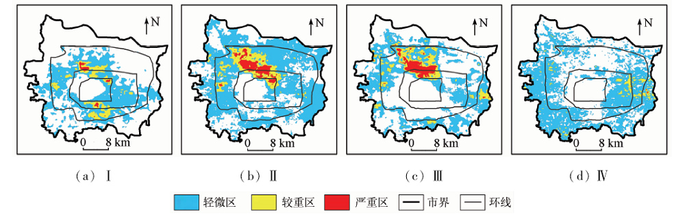
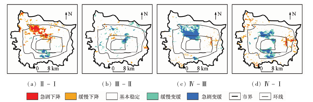
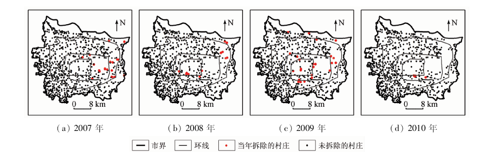
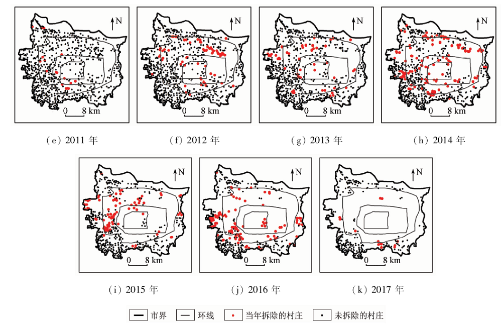
The monitoring results in recent years show that land subsidence in Zhengzhou has been developed rapidly. In order to find out the evolution law of Zhengzhou’s land subsidence and serve the prevention and control work of urban land subsidence, the authors selected the synthetic aperture Radar(SAR) data in recent years (2007—2017), compiled the land subsidence distribution maps of Zhengzhou in four periods of 2007—2010, 2012—2013, 2013—2016 and 2016—2017 by combining with the bench-mark monitoring results, and analyzed the evolution law of Zhengzhou’s land subsidence from time and space. By the GIS room analysis method, the authors studied the space-time response relation between land subsidence and urban village evolution in recent years. Research results show that the urban village is the predominant factor in the land subsidence evolution of Zhengzhou, namely, the groundwater abstraction in urban village causes land subsidence; the relocation of urban village and reduction of groundwater abstraction cause slow land subsidence and even uplift of land subsidence; the relocation causes the floating population to move to outer suburbs, which forms a new floating population and industrial accumulation area, and further forms a new ground subsidence area.

Key wordsSAR    land subsidence    evolution law    urban village
收稿日期: 2019-11-29      出版日期: 2020-10-09
:  TP79  
基金资助:国家自然科学基金仪器专项“面向高陡岩质边坡滑坡机理的查分干涉雷达测量仪”(61427802);河南省国土资源厅地质科研项目“郑州市地面沉降成因机理及防控措施研究”(2018-132-11);安徽省自然资源科技项目“基于PS-InSAR的皖北地区地面沉降长时序监测方法研究”(2016-k-8)
作者简介: 汪宝存(1980-),男,硕士,高级工程师,主要从事基于InSAR的地表形变调查与监测工作。Email: wangbc@cegn.gov.cn
引用本文:   
汪宝存, 朱琳, 潘登, 郭凌飞, 彭鹏. 郑州市地面沉降时空演变规律研究[J]. 国土资源遥感, 2020, 32(3): 143-148.
WANG Baocun, ZHU Lin, PAN Deng, GUO Lingfei, PENG Peng. Research on temporal and spatial evolution law of land subsidence in Zhengzhou. Remote Sensing for Land & Resources, 2020, 32(3): 143-148.
链接本文:  
https://www.gtzyyg.com/CN/10.6046/gtzyyg.2020.03.19      或      https://www.gtzyyg.com/CN/Y2020/V32/I3/143
时段 卫星 图像数
量/景
空间分
辨率/m
时间
ENVISAT-1 20 20 2007年9月—2010年10月
TerraSAR-X 17 3 2012年9月—2013年9月
Radarsat-2 15 30 2013年9月—2016年2月
Radarsat-2 12 5 2016年2月—2017年2月
Tab.1  所采用的SAR图像
Fig.1  郑州市地面沉降分区
(图中环线从内往外为二环、三环、四环)
Fig.2  郑州市地面沉降变幅图
(图中环线从内往外为二环、三环、四环)
时间段 轻微区 较重区 严重区 总面积
302.5 52.8 5.9 361.2
540.5 70.1 34.9 645.5
336.2 67.8 32.3 436.3
498.8 25.8 0.3 524.9
Tab.2  地面沉降分区面积
时间段 急剧
下降
缓慢
下降
沉降加剧
总面积
缓慢
变缓
急剧
变缓
沉降变缓
总面积
Ⅱ-Ⅰ 32.9 65.0 97.9 15.0 8.1 23.1
Ⅲ-Ⅱ 1.9 14.8 16.7 30.7 10.2 40.9
Ⅳ-Ⅲ 1.2 18.6 19.8 36.7 58.0 94.7
Ⅳ-Ⅰ 9.4 50.6 60.0 42.5 35.3 77.8
Tab.3  地面沉降变幅分区面积
Fig.3-1  郑州市城中村拆迁过程
(图中环线从内往外为二环、三环、四环)
Fig.3-2  郑州市城中村拆迁过程
(图中环线从内往外为二环、三环、四环)
时间段 轻微区 较重区 严重区
218 34 5
314 31 20
192 50 9
194 19 0
  不同沉降分区内城中村的数量
时间段 急剧下降区 缓慢下降区 缓慢变缓区 急剧变缓区
前一时
段/个
后一时
段/个
保有
率/%
前一时
段/个
后一时
段/个
保有
率/%
前一时
段/个
后一时
段/个
保有
率/%
前一时
段/个
后一时
段/个
保有
率/%
Ⅱ-Ⅰ 17 12 71 41 32 78 10 5 50 6 2 33
Ⅲ-Ⅱ 3 3 100 13 11 85 5 0 0 4 0 0
Ⅳ-Ⅲ 1 1 100 11 11 100 8 6 75 19 6 32
Ⅳ-Ⅰ 10 9 90 54 38 70 26 2 8 25 2 8
Tab.5  地面沉降变幅区内城中村的数量
年份 地下水位
埋深/m
地下水降落
漏斗面积/km2
当年拆掉
的村庄/个
当年一直存
在的村庄/个
2013年 75.9 152.9 15 56
2014年 64.1 133.6 17 39
2015年 60.1 88.0 24 15
2016年 55.7 85.1 9 6
2017年 53.3 76.5 2 4
Tab.6  降落漏斗范围内2013—2017年间城中村的数量
时间段 轻微区 较重区 严重区
57.8 36.0 29.8
44.7 1.8 0
Tab.7  降落漏斗范围内地面沉降分区面积
[1] 吴建中. 中国地面沉降地质灾害区划方法与实践[J].上海国土资源, 2011(2):84-87.
Wu J Z. Method and application of land subsidence disaster regionalization[J].Shanghai Land & Resources 2011(2):84-87.
[2] 张永红, 吴宏安, 康永辉. 京津冀地区1992—2014年三阶段地面沉降InSAR监测[J]. 测绘学报, 2016,45(9):1050-1058.
Zhang Y H, Wu H A, Kang Y H. Ground subsidence over Beijing-Tianjin-Hebei region during three periods of 1992 to 2014 monitored by interferometric SAR[J]. Acta Geodateica et Cartographica Sinica, 2016,45(9):1050-1058.
[3] 田芳, 罗勇, 周毅, 等. 北京地面沉降与地下水开采时空演变对比[J]. 南水北调与水利科技, 2017,15(2):163-169.
Tian F, Luo Y, Zhou Y, et al. Contrastive analysis of spatial-temporal evolution between land subsidence and groundwater exploitation in Beijing[J]. South-to-North Water Transfers and Water Science & Technology, 2017,15(2):163-169.
[4] 葛大庆, 张玲, 王艳, 等. 上海地铁10号线建设与运营过程中地面沉降效应的高分辨率InSAR监测及分析[J].上海国土资源, 2014(4):62-67.
Ge D Q, Zhang L, Wang Y, et al. Monitoring subsidence on Shanghai metro line 10 during construction and operation using high-resolution InSAR[J].Shanghai Land & Resources 2014(4):62-67.
[5] 范景辉, 李梅, 郭小方, 等. 基于PSInSAR方法和ASAR数据监测天津地面沉降的试验研究[J]. 国土资源遥感, 2007,19(4):23-27.doi: 10.6046/gtzyyg.2007.04.05.
Fan J H, Li M, Guo X F, et al. A preliminary study of the subsidence in Tianjin area using ASAR images based on PSInSAR technique[J]. Remote Sensing for Land and Resources, 2007,19(4):23-27.doi: 10.6046/gtzyyg.2007.04.05.
[6] 郭新华, 李建欣. 开展郑州市地面沉降监测工作的必要性[J], 中国地质灾害与防治学报, 2007,18(1):147-148.
Guo X H, Li J X. The necessity of land subsidence monitoring in Zhengzhou[J]. The Chinese Journal of Geological Hazard and Control, 2007,18(1):147-148.
[7] 汪宝存, 李芳芳, 潘登, 等. PS-InSAR技术在郑州市地面沉降调查中的应用[J]. 测绘科学, 2013,38(5):43-45.
Wang B C, Li F F, Pan D, et al. Application of PS-InSAR technology in land subsidence investigation of Zhengzhou[J]. Science of Surveying and Mapping, 2013,38(5):43-45.
[8] 王义梅, 罗小军, 于冰, 等. 郑州市地面沉降InSAR监测[J]. 测绘科学, 2019,44(9):100-106.
Wang Y M, Luo X J, Yu B, et al. Monitoring ground subsidence in Zhengzhou with InSAR[J]. Science of Surveying and Mapping, 2019,44(9):100-106.
[9] 管力, 唐伟, 戴华阳, 等. 采用SBAS-InSAR技术监测郑州城区地面沉降[J]. 北京测绘, 2019,33(4):462-467.
Guan L, Tang W, Dai H Y, et al. Monitoring ground subsidence in Zhengzhou City based on SBAS-InSAR technology[J]. Beijing Surverying and Mapping, 2019,33(4):462-467.
[10] 夏飞雪, 姚青, 聂明军. 京广高铁郑州段地面沉降原因分析[J]. 地下水, 2014,36(4):97-98.
Xia F X, Yao Q, Nie M J. Reason analysis of land subsidence in Zhengzhou section of Beijing Guangzhou high speed railway[J]. Ground Water, 2014,36(4):97-98.
[11] 詹学启, 张占荣. 郑徐高速铁路郑州段区域地面沉降预测分析[J]. 铁道标准设计, 2014,58(7):56-60.
Zhan X Q, Zhang Z R. Prediction and analysis of regional land subsidence in Zhengzhou section of Zheng Xu high speed railway[J]. Railway Standard Design, 2014,58(7):56-60.
[12] 朱卫民, 汪宝存, 宋会传, 等. 基于InSAR的京广高铁郑州段地面沉降调查与监测[J]. 测绘与空间地理信息, 2019,42(9):61-63.
Zhu W M, Wang B C, Song H C, et al. Investination and monitoring of ground subsidence in Zhengzhou section of high-speed railway between Beijing and Guangzhou[J]. Geomatics & Spatial Information Technology, 2019,42(9):61-63.
[13] 刘勇. 黄河三角洲地区地面沉降时空演变特征及机理研究[D]. 青岛:中国科学院海洋研究所, 2013.
Liu Y. Spatiotemporal evolution of land subsidence and mechanism discussion in the Yellow River Delta,China[D].Tsingtao:Institute of Oceanology,Chinese Academy of Science, 2013.
[14] 刘杰. 郑州市流动人口信息服务与管理研究[D]. 郑州:郑州大学, 2014.
Liu J. Zhengzhou City information service and management of the floating population study[D]. Zhengzhou:Zhengzhou University, 2014.
[15] 王元亮. 郑州城中村改造现状、困境与对策[J]. 现代城市, 2015,10(2):11-14.
Wang Y L. The status quo,dilemma,and countermeasure of the reconstruction of urban village in Zhengzhou[J]. Modern City, 2015,10(2):11-14.
[16] 豆敬峰, 田君慧, 潘登, 等. 郑州市地下水动态监测报告(2007—2017)[R]. 郑州:河南省地质环境监测院, 2017.
Dou J F, Tian J H, Pan D, et al. Report on groundwater dynamic monitoring in Zhengzhou(2007—2017)[R].Zhengzhou:Henan Geo-Environmental Monitoring Institute, 2015.
[1] 杨旺, 何毅, 张立峰, 王文辉, 陈有东, 陈毅. 甘肃金川矿区地表三维形变InSAR监测[J]. 自然资源遥感, 2022, 34(1): 177-188.
[2] 臧丽日, 杨树文, 申顺发, 薛庆, 秦肖伟. 耦合分水岭与形态学的特殊纹理影像配准算法[J]. 自然资源遥感, 2022, 34(1): 76-84.
[3] 周超凡, 宫辉力, 陈蓓蓓, 雷坤超, 施轹原, 赵宇. 联合WT-RF的津保高铁沿线地面沉降预测[J]. 自然资源遥感, 2021, 33(4): 34-42.
[4] 李梦梦, 范雪婷, 陈超, 李倩楠, 杨锦. 徐州矿区2016—2018年地面沉降监测与分析[J]. 自然资源遥感, 2021, 33(4): 43-54.
[5] 史珉, 宫辉力, 陈蓓蓓, 高明亮, 张舜康. Sentinel-1A京津冀平原区2016—2018年地面沉降InSAR监测[J]. 自然资源遥感, 2021, 33(4): 55-63.
[6] 李渊, 毋琳, 戚雯雯, 郭拯危, 李宁. 基于改进OGMRF-RC模型的SAR图像分类方法[J]. 自然资源遥感, 2021, 33(4): 98-104.
[7] 艾璐, 孙淑怡, 李书光, 马红章. 光学与SAR遥感协同反演土壤水分研究进展[J]. 自然资源遥感, 2021, 33(4): 10-18.
[8] 于冰, 谭青雪, 刘国祥, 刘福臻, 周志伟, 何智勇. 高分辨率TerraSAR-X时序差分干涉沉降监测及精度验证[J]. 自然资源遥感, 2021, 33(4): 26-33.
[9] 沙永莲, 王晓文, 刘国祥, 张瑞, 张波. 基于SBAS InSAR的新疆哈密砂墩子煤田开采沉陷监测与反演[J]. 自然资源遥感, 2021, 33(3): 194-201.
[10] 冯东东, 张志华, 石浩月. 基于多元数据的省会城市城中村精细提取[J]. 自然资源遥感, 2021, 33(3): 272-278.
[11] 张腾, 谢帅, 黄波, 范景辉, 陈建平, 童立强. 利用Sentinel-1和ALOS-2数据探测茂县中部活动滑坡[J]. 国土资源遥感, 2021, 33(2): 213-219.
[12] 何海英, 陈彩芬, 陈富龙, 唐攀攀. 张家口明长城景观廊道Sentinel-1影像SBAS形变监测示范研究[J]. 国土资源遥感, 2021, 33(1): 205-213.
[13] 江珊, 王春, 宋宏利, 刘玉锋. 基于SAR与光学遥感数据相结合的农作物种植类型识别研究[J]. 国土资源遥感, 2020, 32(4): 105-110.
[14] 孙超, 陈振杰, 王贝贝. 基于SAR时间序列的建设用地扩展监测——以常州市新北区为例[J]. 国土资源遥感, 2020, 32(4): 154-162.
[15] 于海若, 宫辉力, 陈蓓蓓, 周超凡. 新水情下利用InSAR-GRACE卫星的新兴风险预警与城市地下空间安全展望[J]. 国土资源遥感, 2020, 32(4): 16-22.
Viewed
Full text


Abstract

Cited

  Shared   
  Discussed   
京ICP备05055290号-2
版权所有 © 2015 《自然资源遥感》编辑部
地址:北京学院路31号中国国土资源航空物探遥感中心 邮编:100083
电话:010-62060291/62060292 E-mail:zrzyyg@163.com
本系统由北京玛格泰克科技发展有限公司设计开发