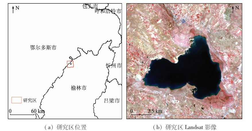
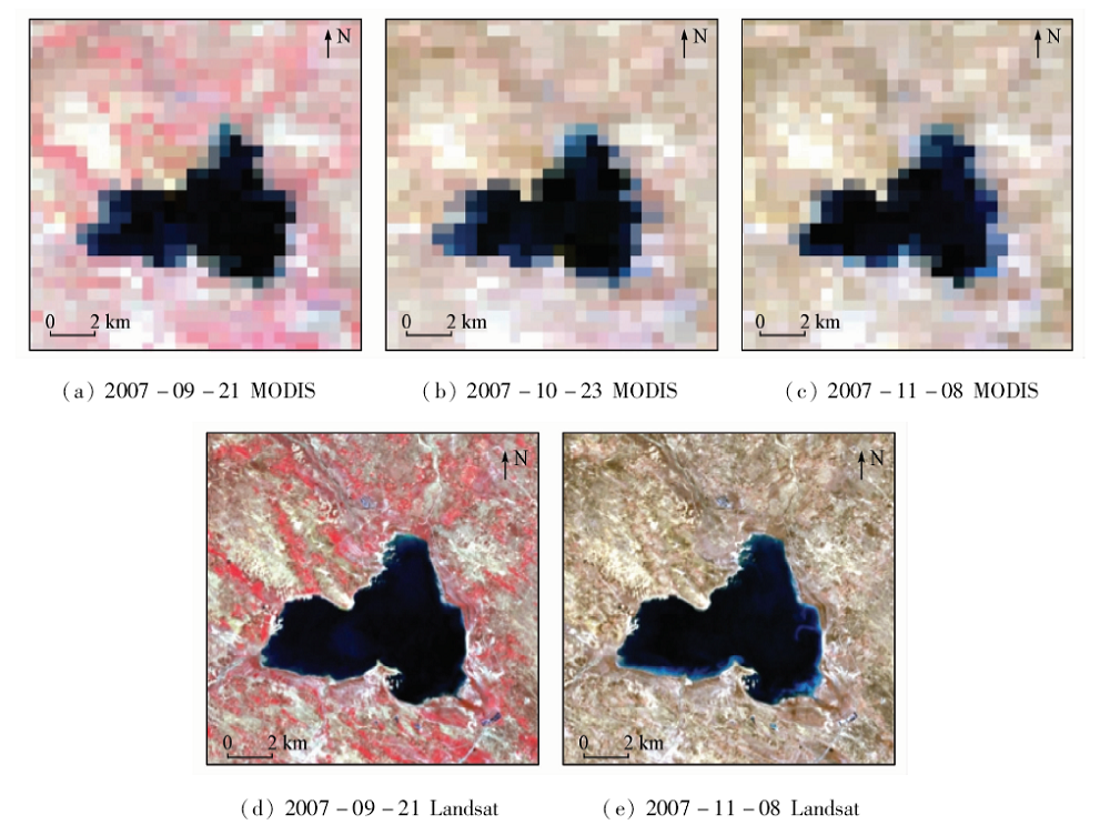
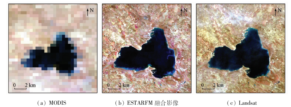
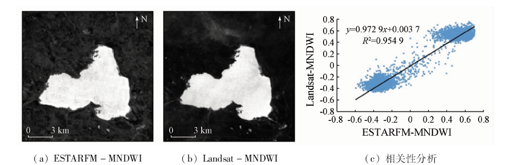
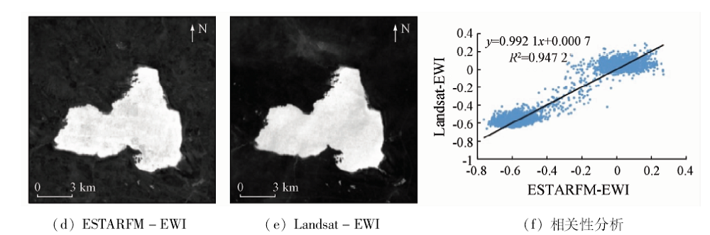
According to the fact that data missing problem often occurs during the study of long-term remote sensing dynamic monitoring of inland lake area, the authors tried to make up for the missing remote sensing images by utilizing the ESTARFM to combine with the MODIS data so as to simulate the missing Landsat images after 2000. On such a basis, the water index method was used to extract the lake area and shoreline so as to realize the long-term remote sensing dynamic monitoring of inland lake. Hongjiannao Lake in Inner Mongolia was selected as the study area. The method was tested by making up for the missing Landsat images from 1987 to 2018 with ESTARFM algorithm and extracting Hongjiannao Lake from all the images. Some conclusions have been reached: The MODIS and Landsat fusion images generated by the ESTARFM algorithm are ideal, which can effectively solve the problem of missing Landsat images after 2000. It is proved that the image obtained from the ESTARFM fusion can be applied to water extraction. In addition, time-series images with the fusion images are added to reflect the water changes more delicately when the water dynamic change is monitored, which contributes to the subsequent research. In addition, through the long-term remote sensing dynamic change monitoring of Hongjiannao, it is found that the lake changes generally show a shrinking stage, and the specifics can be divided into three stages: stability, sustained shrinkage and growth.
程筱茜, 洪友堂, 陈劲松, 叶宝莹. 基于ESTARFM的内陆湖泊遥感动态变化监测[J]. 国土资源遥感, 2020, 32(3): 183-190.
CHENG Xiaoqian, HONG Youtang, CHEN Jinsong, YE Baoying. A study of the long-term remote sensing dynamic monitoring of inland based on ESTARFM. Remote Sensing for Land & Resources, 2020, 32(3): 183-190.
Hu A Y. Analysis of the impacts of climate change and human activities on inland lakes[J].Journal of Arid Land Resources and Environment 2007(5):1-5.
[4]
Pohl C, Van Genderen J L. Review article multisensor image fusion in remote sensing:Concepts,methods and applications[J]. International Journal of Remote Sensing, 1998,19(5):823-854.
doi: 10.1080/014311698215748
Xie D F, Zhang J S, Pan Y Z, et al. Fusion of MODIS and Landsat8 images to generate high spatial-temporal resolution data for mapping autumn crop distribution[J]. Journal of Remote Sensing, 2015,19(5):791-805.
Liu Y M, Ma L, Huang C, et al. Study on the change of vegetation coverage of Loss Plateau in northern Shaanxi Province based on MODIS-Landsat fusion data[J].Journal of Northwest University(Natural Science Edition) 2019(1):62-70.
[7]
Jia K, Liang S L, Wei X Q, et al. Land cover classification of landsat data with phenological features extracted from time series MODIS NDVI data[J]. Remote Sensing, 2014,6(11):11518-11532.
doi: 10.3390/rs61111518
[8]
Zhu X L, Jin C, Feng G, et a1. An enhanced spatial and temporal adaptive reflectance fusion model for complex heterogeneous regions[J]. Remote Sensing of Environment, 2010,114(11):2610-2623.
doi: 10.1016/j.rse.2010.05.032
[9]
Acerbi-Junior F W, Clevers J G P W, Schaepman M E. The assessment of multi-sensor image fusion using wavelet transforms for mapping the Brazilian Savanna[J]. International Journal of Applied Earth Observation and Geoinformation, 2006,8(4):278-288.
doi: 10.1016/j.jag.2006.01.001
Gu X H, Han L J, Wang J H, et al. Estimation of maize planting area based on wavelet fusion of multi-resolution images[J]. Transactions of the Chinese Society of Agricultural Engineering, 2012,28(3):203-209.
[11]
Zhukov B, Oertel D, Lanzl F, et al. Unmixing-based multisensor multiresolution image fusion[J]. IEEE Transactions on Geoscience and Remote Sensing, 1999,37(3):1212-1226.
doi: 10.1109/36.763276
[12]
Maselli F. Definition of spatially variable spectral endmembers by locally calibrated multivariate regression analyses[J]. Remote Sensing of Environment, 2001,75(1):29-38.
doi: 10.1016/S0034-4257(00)00153-X
[13]
Busetto L, Meroni M, Colombo R. Combining medium and coarse spatial resolution satellite data to improve the estimation of sub-pixel NDVI time series[J]. Remote Sensing of Environment, 2008,112(1):118-131.
doi: 10.1016/j.rse.2007.04.004
[14]
Gao F, Masek J, Schwaller M, et al. On the blending of the Landsat and MODIS surface reflectance:Predicting daily Landsat surface reflectance[J]. IEEE Transactions on Geoscience and Remote Sensing, 2006,44(8):2207-2218.
doi: 10.1109/TGRS.2006.872081
[15]
Mcfeeters S K. The use of the normalized difference water index (NDWI) in the delineation of open water features[J]. International Journal of Remote Sensing, 1996,17(7):1425-1432.
doi: 10.1080/01431169608948714
Xu H Q. A study on information extraction of waterbody with the modified normalized difference water index(MNDWI)[J]. Journal of Remote Sensing, 2005,9(5):589-595.
doi: 10.11834/jrs.20050586
[17]
Yan P, Zhang Y J, Zhang Y. A study on information extraction of water system in semi-arid regions with the enhanced water index(EWI) and GIS based noise remove techniques[J].Remote Sensing Information, 2007(6):62-67.
Li D K, He H J, Liu A L. Effects of human activities and climate change on vegetation cover change of Hongjiannao[J]. Journal of Desert Research, 2010,30(4):831-836.
Tang K W, Wang H, Liu C. Preliminary study on lake change and ecological water demand in Hongjiannao,northern Shaanxi Province[J].Journal of Natural Resources 2003(3):304-309.
doi: 10.11849/zrzyxb.2003.03.007
Li D K, Zhuo J, Wang Z. Effect of human activities and climate change on the water surface area of Hongjiannao[J]. Journal of Glaciology and Geocryology, 2009,31(6):1110-1115.
Yang L B, Huang Q, Wu J, et al. Influencing factors and prediction analysis of lake area change of Hongjiannao[J]. Journal of Arid Land Resources and Environment, 2014,28(3):74-78.
 2020, Vol. 32
  ), 洪友堂(