Extraction of paddy rice based on convolutional neural network using multi-source remote sensing data
CAI Yaotong1,2,3,4(), LIU Shutong4, LIN Hui1,2,3,4, ZHANG Meng1,2,3,4()
1. Research Center of Forestry Remote Sensing and Information Engineering, Central South University of Forestry and Technology, Changsha 410004, China 2. Key Laboratory of Forestry Remote Sensing Based Big Data and Ecological Security for Hunan Province, Changsha 410004, China 3. Key Laboratory of State Forestry Administration on Forest Resources Management and Monitoring in Southern Area, Changsha 410004, China 4. College of Forestry, Central South University of Forestry and Technology, Changsha 410004, China
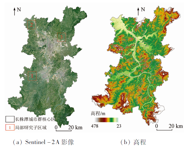
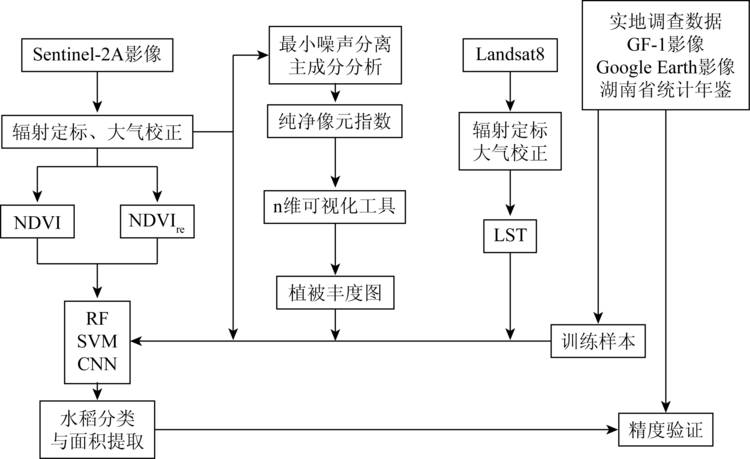
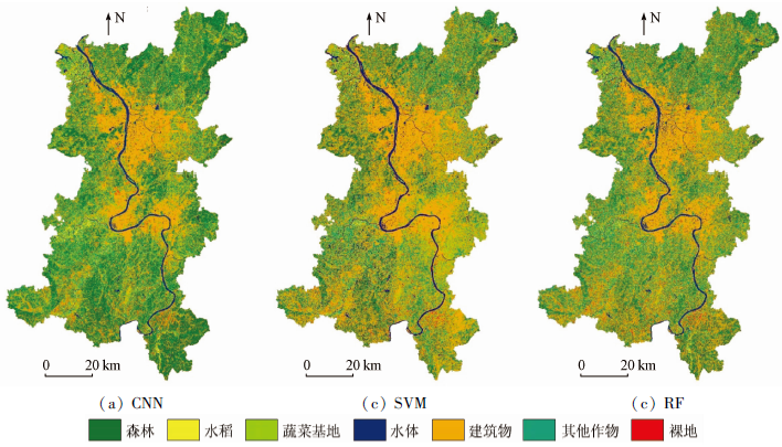
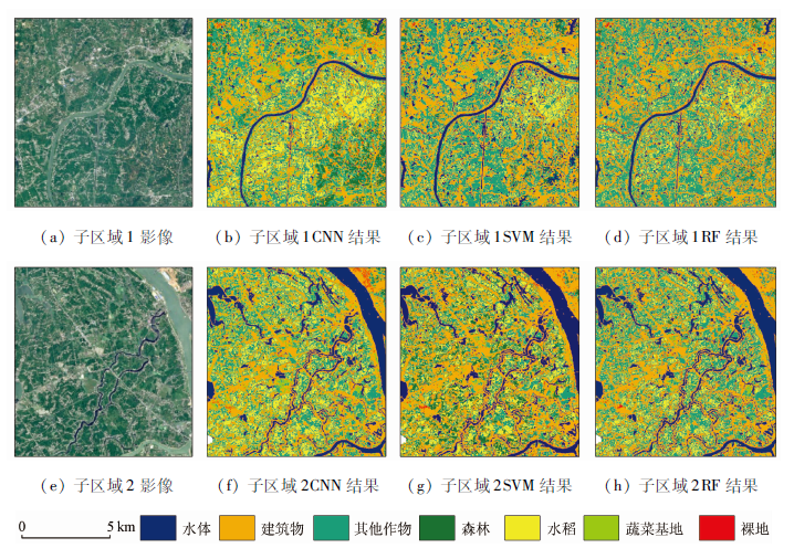
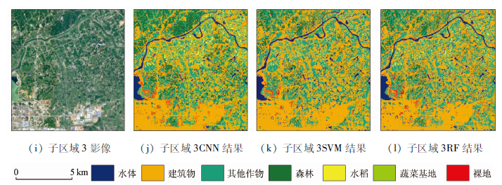
Rice is one of the most widely planted food crops in China. Therefore, timely and accurate rice identification and monitoring is of great significance to the national food security and the evolution of agricultural land spatial pattern. In this study, multi-temporal Sentinel-2A multispectral images, vegetation indices, vegetation abundance and Landsat 8 derived LST on the critical period of rice phenology were used. The CNN, SVM and RF classifiers were applied to extracting the paddy rice and finally the paddy rice map was obtained. The result shows that using multi-temporal and multi-source remote sensing data with the CNN algorithm can effectively extract rice information in high heterogeneity region. The overall accuracy of rice classification and Kappa coefficient are over 92% and 0.90 respectively. This study has demonstrated the potential of using moderate spatial resolution images combined with CNN to map the paddy rice in highly heterogeneous area.
蔡耀通, 刘书彤, 林辉, 张猛. 基于多源遥感数据的CNN水稻提取研究[J]. 国土资源遥感, 2020, 32(4): 97-104.
CAI Yaotong, LIU Shutong, LIN Hui, ZHANG Meng. Extraction of paddy rice based on convolutional neural network using multi-source remote sensing data. Remote Sensing for Land & Resources, 2020, 32(4): 97-104.
Luo G C. Rice in south China,land characteristics,farmers planting patterns:Empirical analysis based on survey data of five southern provinces rice farmers[D]. Guangzhou:South China Agricultural University, 2016.
[2]
Dong J, Xiao X. Evolution of regional to global paddy rice mapping methods:A review[J]. ISPRS Journal of Photogrammetry and Remote Sensing, 2016,119(1):214-227.
[3]
Bachelet D. Rice paddy inventory in a few provinces of China using AVHRR data[J]. Geocarto International, 1995,10(1):23-38.
[4]
Xiao X, Boles S, Frolking S, et al. Mapping paddy rice agriculture in South and Southeast Asia using multi-temporal MODIS images[J]. Remote Sensing of Environment, 2006,100(1):95-113.
[5]
Cai Y T, Zhang M, Lin H. Mapping paddy rice by the object-based random forest method using time series Sentinel-1/Sentinel-2 data[J]. Advance in Space Research, 2019,64(11):2233-2244.
[6]
Thenkabail P S. Mapping rice areas of south Asia using MODIS multitemporal data[J]. Journal of Applied Remote Sensing, 2011,5(4):863-871.
[7]
Dong J, Xiao X, Kou W, et al. Tracking the dynamics of paddy rice planting area in 1986—2010 through time series Landsat images and phenology-based algorithms[J]. Remote Sensing of Environment, 2015,160(160):99-113.
Zhang M, Zeng Y N. Mapping paddy fields of Dongting Lake area by fusing Landsat and MODIS data[J]. Transactions of the Chinese Society of Agricultural Engineering, 2015,31(13):178-185.
Yang B, Li D, Gao G S, et al. Processing analysis of Sentinel-2A data and application to arid valleys extraction[J]. Remote Sensing for Land and Resources, 2018,30(3):128-135.doi: 10.6046/gtzyyg.2018.03.18.
[10]
Lambert M, Traore P, Blaes X, et al. Estimating smallholder crops production at village level from Sentinel-2 time series in Mali’s cotton belt[J]. Remote Sensing of Environment, 2018,216(1):647-657.
[11]
Toshihiro S, Masayuki Y, Hitoshi T, et al. A crop phenology detection method using time-series MODIS data[J]. Remote Sensing of Environment, 2005,96(3):366-374.
[12]
Wardlow B D, Egbert S L. Large-area crop mapping using time-series MODIS 250 m NDVI data:An assessment for the U.S. Central Great Plains[J]. Remote Sensing of Environment, 2008,112(3):1096-1116.
Guo X Y, Li K, Wang Z Y, et al. Fine classification of rice with multi-temporal compact polarimetric SAR based on SVM+SFS strategy[J]. Remote Sensing for Land and Resources, 2018,30(4):20-27.doi: 10.6046/gtzyyg.2018.04.04.
[14]
Qin Y, Xiao X, Dong J, et al. Mapping paddy rice planting area in cold temperate climate region through analysis of time series Landsat8 (OLI),Landsat7 (ETM+) and MODIS imagery[J]. ISPRS Journal of Photogrammetry and Remote Sensing, 2015,105:220-233.
doi: 10.1016/j.isprsjprs.2015.04.008
pmid: 27695195
[15]
Erinjery J, Singh M, Kent R. Mapping and assessment of vegetation types in the tropical rainforests of the Western Ghats using multispectral Sentinel-2 and SAR Sentinel-1 satellite[J]. Remote Sensing of Environment, 2018,216(1):345-354.
[16]
Romero A, Gatta C, Camps-vall G. Unsupervised deep feature extraction for remote sensing image classification[J]. IEEE Transactions on Geoscience and Remote Sensing, 2016,54(3):1349-1362.
[17]
Maggiori E, Tarabalka Y, Charpiat G, et al. Convolutional neural networks for large-scale remote-sensing image classification[J]. IEEE Transactions on Geoscience and Remote Sensing, 2016,55(2):645-657.
doi: 10.1109/TGRS.2016.2612821
[18]
Pan X, Zhao J. High-resolution remote sensing image classification method based on convolutional neural network and restricted conditional random field[J]. Remote Sensing, 2018,920(10):1-20.
Cai Y T, Lin H, Sun H, et al. Stand allocation high inversion method based on TanDEM-X data[J]. Journal of Southwest Forestry University (Natural Sciences), 2019,39(5):110-117.
Zhao L, Zhang J S, Hu T G, et al. The application of the dynamic endmember linear spectral unmixing model to winter wheat area estimation[J]. Remote Sensing for Land and Resources, 2011,23(1):66-72.doi: 10.6046/gtzyyg.2011.01.13.
[21]
Zhang M, Lin H, Wang G, et al. Mapping paddy rice using a convolutional neural network (CNN) with Landsat8 datasets in the Dongting Lake area,China[J]. Remote Sensing, 2018,10(11), 1840.
Xu H Q. Retrieval of the reflectance and land surface temperature of the newly-launched Landsat8 satellite[J]. Chinese Journal of Geophysics, 2015,58(3):741-747.
[23]
Azizpour H, Razavian A S, Sullivan J, et al. Factors of transferability for a generic ConvNet representation[J]. IEEE Transactions on Pattern Analysis and Machine Intelligence, 2015,38(9):1790-1802.
doi: 10.1109/TPAMI.2015.2500224
pmid: 26584488
[24]
Kontgis C, Schneider A, Ozdogan M. Mapping rice paddy extent and intensification in the Vietnamese Mekong River Delta with dense time stacks of Landsat data[J]. Remote Sensing of Environment, 2015,169:255-269.
doi: 10.1016/j.rse.2015.08.004
 2020, Vol. 32
  ), 刘书彤4, 林辉1,2,3,4, 张猛1,2,3,4(