Estimation of wheat planting density using UAV image
WANG Wei1,2(), WANG Xinsheng1,2, YAO Chan1,2, JIN Tian1,2, WU Jiayu1,2, SU Wei1,2()
1. College of Land Science and Technology, China Agricultural University, Beijing 100083, China 2. Key Laboratory of Remote Sensing for Agri-Hazards, Ministry of Agriculture, Beijing 100083, China
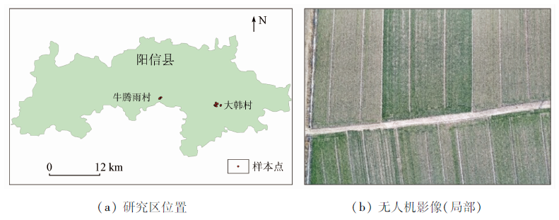
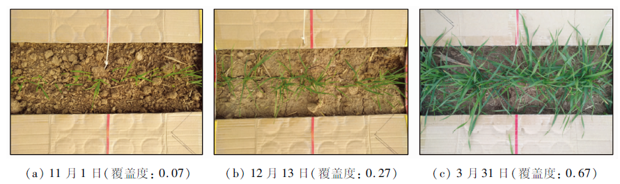
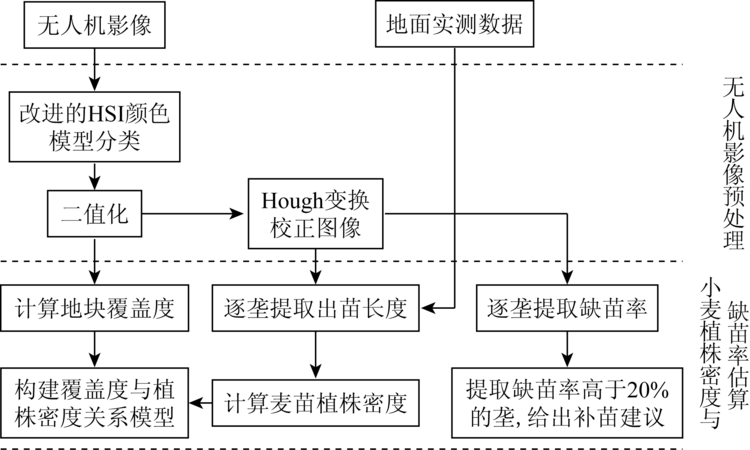
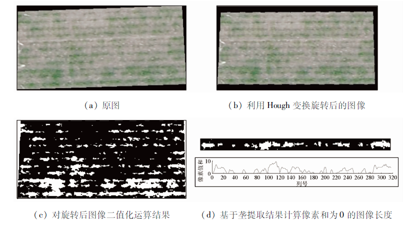
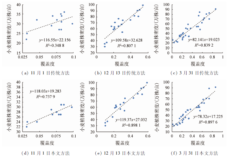
Wheat is a densely planted crop, and the planting volume per acre is nearly 20 kg. The plant density of winter wheat will directly affect the final yield. Therefore, real-time monitoring of wheat plant density is an important way to ensure wheat yield. At present, the main method for obtaining the plant density of wheat is mainly manual measurement, which is time-consuming and laborious. In this paper, the DJ inspire 2 UAV is equipped with a Zens X4S camera to obtain high-resolution visible light images of wheat planting areas, extract wheat coverage based on UAV images, and establish the relationship between plant density and plant density so as to achieve rapid acquisition of wheat plant density based on UAV image. Experiments show the following results: ① Using the improved HSI color model to extract wheat coverage improves accuracy and extraction efficiency compared with traditional visual estimation, manual counting and other classification methods, and overcomes differences in lighting conditions and shadows of different sorts of UAV images influences. ② There is a high correlation between wheat coverage and plant density at the seedling stage, overwintering stage and turning green stage. Among them, the correlation coefficient R2 between the coverage based on drone image and the plant density of wheat are 0.737 9, 0.898 1 and 0.897 6 in three growth stages. The verification results of the relationship model using Niutengyu Village samples show that the inversion results based on the established relationship model also have a good correlation with the measured values, and R2 reaches 0.919 8.
王伟, 王新盛, 姚婵, 金添, 邬佳昱, 苏伟. 基于无人机影像的小麦植株密度估算方法研究[J]. 国土资源遥感, 2020, 32(4): 111-119.
WANG Wei, WANG Xinsheng, YAO Chan, JIN Tian, WU Jiayu, SU Wei. Estimation of wheat planting density using UAV image. Remote Sensing for Land & Resources, 2020, 32(4): 111-119.
Zhou J B, Liu L. Study on the differences of the impact of future climate change on wheat yield in China quantitative review based on Meta regression analysis[J]. Chinese Journal of Agrometeorology, 2018,39(3):141-151.
Huang D F. Research progress of planting density affecting rice agronomic traits[J]. Auhui Agricultural Science Bulletin, 2012,18(1):70-71.
[4]
Jin X, Li Z, Yang G, et al. Winter wheat yield estimation based on multi-source medium resolution optical and Radar imaging data and the Aqua Crop model using the particle swarm optimization algorithm[J]. ISPRS Journal of Photogrammetry and Remote Sensing, 2017,126:24-37.
Zhao S Y, Gong Z N, Liu X Y. Correlation analysis between vegetation coverage and climate drought conditions in North China during 2001—2013[J]. Acta Geographica Sinica, 2015(5):31-43.
Xing Z R, Feng Y G, Yang G J, et al. Method of estimating vegetation coverage based on remote sensing[J]. Remote Sensing Technology and Application, 2009,24(6):849-854.
[7]
Yang G J, Liu J G, Zhao C J, et al. Unmanned aerial vehicle remote sensing for field-based crop phenotyping:Current status and perspectives[J]. Frontiers in Plant Science, 2017,8:1111.
doi: 10.3389/fpls.2017.01111
pmid: 28713402
Sun G, Huang W J, Chen P F, et al. Advances in UAV-based multispectral remote sensing applications[J]. Transactions of the Chinese Society for Agricultural Machinery, 2018,49(3):1-17.
Liu J G, Zhao C J, Yang G J, et al. Review of field-based phenotyping by unmanned aerial vehicle remote sensing platform[J]. Transactions of the Chinese Society of Agricultural Engineering, 2016,32(24):98-106.
Wang K, Fu Y R, Peng X Y, et al. Overview of UAV low altitude remote sensing technology and application in typical industries[J]. Bulletin of Surveying and Mapping, 2017(s1):79-83.
[11]
Primicerio J, Gennaro S F D, Fiorillo E, et al. A flexible unmanned aerial vehicle for precision agriculture[J]. Precision Agriculture, 2012,13(4):517-523.
[12]
Sugiura R, Tsuda S, Tamiya S, et al. Field phenotyping system for the assessment of potato late blight resistance using RGB imagery from an unmanned aerial vehicle[J]. Biosystems Engineering, 2016,148:1-10.
Liu F, Liu S H, Xiang Y. Study on monitoring fractional vegetation cover of garden plots by unmanned aerial vehicles[J]. Transactions of the Chinese Society for Agricultural Machinery, 2014,45(11):250-257.
Feng H Y, Feng Z K, Feng H X. A new method for estimating the fractional vegetation cover based on UVA hyperspectrum[J]. Spectroscopy and Spectral Analysis, 2017,37(11):3573-3578.
Zhou Z M, Yang Y M, Chen B Q. Fractional vegetation cover of invasive spartina alterniflora in coastal wetland using unmanned aerial vehicle (UAV) remote sensing[J]. Journal of Applied Ecology, 2016,27(12):3920-3926.
doi: 10.13287/j.1001-9332.201612.006
pmid: 29704351
Guo Z D, Gu Z D, Xu S, et al. UAV-based investigation of community vegetation coverage[J]. Beijing Surveying and Mapping, 2017(5):88-91.
[17]
Chen J, Yi S, Yu Q, et al. Improving estimates of fractional vegetation cover based on UAV in alpine grassland on the Qinghai-Tibetan Plateau[J]. International Journal of Remote Sensing, 2016,37(8):1922-1936.
Ge J, Meng B P, Yang S X, et al. Dynamic monitoring of alpine grassland coverage based on UAV technology and MODIS remote sensing data:A case study in the headwaters of the Yellow River[J]. Acta Prataculturae Sinica, 2017,26(3):1-12.
Li B, Liu R Y, Liu S H, et al. Monitoring vegetation coverage variation of winter wheat by low-altitude UAV remote sensing system[J]. Transactions of the Chinese Society of Agricultural Engineering, 2012,28(13):160-165.
Niu Y X, Zhang L Y, Han W T, et al. Fractional vegetation cover extraction method of winter wheat based on UAV remote sensing and vegetation index[J]. Transactions of the Chinese Society for Agricultural Machinery, 2018,49(4):212-221.
Song R X, Sun X D, Wang X C. Haze removal algorithm based on HSI color space and dark channel prior[J]. Journal of Systems Science and Mathematical Sciences, 2017,37(10):2111-2120.
Mao Z C, Sun Y H. Algorithm of male tassel recognition based on HSI space[J]. Transducer and Microsystem Technologies, 2018,37(9):117-119.
[23]
Montalvo M, Pajares G, Guerrero J M, et al. Automatic detection of crop rows in maize fields with high weeds pressure[J]. Expert Systems with Applications, 2012,39(15):11889-11897.
[24]
Slaughter D C, Giles D K, Downey D. Autonomous robotic weed control systems:A review[J]. Computers and Electronics in Agriculture, 2008,61(1):63-78.
[25]
Liu T, Li R, Jin X L, et al. Evaluation of seed emergence uniformity of mechanically sown wheat with UAV RGB imagery[J]. Remote Sensing, 2017,9(12):1-15.
 2020, Vol. 32
  ), 王新盛1,2, 姚婵1,2, 金添1,2, 邬佳昱1,2, 苏伟1,2(