A study on regional ecological barrier construction based on landscape ecological risk
JIANG Lei1(), HAN Weizheng1, SUN Lina2
1. Changchun Urban and Rural Planning and Design Institute, Changchun 130022, China 2. Department of Environmental Science and Engineering, Changchun Institute of Technology, Changchun 130022, China
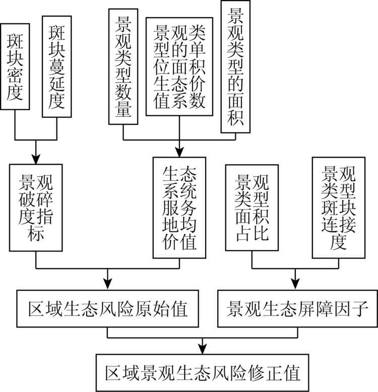
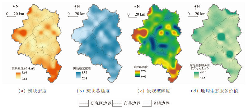
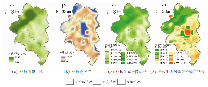
Carrying out territory virescence action and ecological barrier construction is one of the important measures of eco-civilization construction in China. At present, the ecological problems in the northwestern part of Changchun economic circle are relatively prominent, which have become the shortcoming of regional ecological security. Based on the ecological background characteristics and main ecological problems of the study area, the authors constructed a quantitative assessment method for landscape ecological risk including ecological barrier factor. The results are as follows: ① The key areas of ecological barrier construction in the study area include two categories: areas where landscape ecological risk is relatively high, and areas where ecological barrier construction is relatively weak; ② the areas with relatively high landscape ecological risk are mainly distributed in the central part of Nong’an County, accounting for 1.25% and 1.74% of the total area of the study area; ③ the relatively weak areas of ecological barrier construction are the areas where the landscape ecological risk increases after the introduction of ecological barrier factor, mainly distributed in the border zone between Changlin County and Nong’an County, accounting for about 1/4 of the total area. Based on the comprehensive problem-oriented and target-oriented approach, the authors put forward strategies from two aspects of strengthening the control of landscape ecological risk and promoting ecological construction in relatively weak areas, so as to promote the high-quality and sustainable development of Changchun economic circle. This study provides not only a feasible idea for the study of regional ecological barrier construction and related ecological planning but also a useful reference for the optimization of land space spatial pattern.
蒋蕾, 韩维峥, 孙丽娜. 基于景观生态风险的区域生态屏障建设研究[J]. 国土资源遥感, 2020, 32(4): 219-226.
JIANG Lei, HAN Weizheng, SUN Lina. A study on regional ecological barrier construction based on landscape ecological risk. Remote Sensing for Land & Resources, 2020, 32(4): 219-226.
Research group on ecological barrier,functional zoning and population development. Build national ecological barrier to promote coordinated development of population,resources and environment:Research report on problems of population,resources and environment in 8 provinces and regions including Inner Mongolia,Gansu,et al.[J]. Population Research, 2008,32(2):1-4.
Wang Y K, Sun X F, Deng Y L, et al. Discussion on concept definition and academic value of ecological defence[J]. Journal of Mountain Science, 2005(7):431-436.
Cao Q W, Zhang X W, Ma H K, et al. Review of landscape ecological risk and an assessment framework based on ecological services:ESRISK[J]. Acta Geographica Sinica, 2018,73(5):843-855.
Zhou L J, Zhang X P, Chen S. Land use change and ecological risk assessment of Zhalong Natural Protection area[J]. Journal of Natural Disasters, 2009(2):186-190.
Gong J, Zhao C X, Xie Y C, et al. Ecological risk assessment and its management of Bailongjiang watershed,southern Gansu based on landscape pattern[J]. Chinese Journal of Applied Ecology, 2014(7):2041-2048.
pmid: 25345056
Zhang Y, Zhang F, Zhou M, et al. Landscape ecological risk assessment and its spatio-temporal variations in Ebinur Lake region of inland arid area[J]. Chinese Journal of Applied Ecology, 2016,27(1):233-242.
pmid: 27228614
Pan J H, Liu X. Landscape ecological risk assessment and landscape security pattern optimization in Shule River Basin[J]. Chinese Journal of Ecology, 2016,35(3):791-799.
Li Y Y, Huang Y X, Yang Y, et al. Temporal and spatial characteristics of coastal ecological risk in the Fujian Province based on landscape structure[J]. Bulletin of Soil and Water Conservation, 2018,38(4):241-246.
Xi S J, An Y L, Li Y B, et al. Ecological risk assessment of Karst mountain watershed based on landscape pattern:A case study of Wujiang River Basin in Guizhou Province[J]. Resources and Environment in the Yangtze Basin, 2019,28(3):712-721.
Li X Y, Liu S J, Wang Z J. Landscape ecological risk characteristics of water source site in Hanzhong City of the middle route of the South-to-North water transfer project of China[J]. Research of Soil and Water Conservation, 2019,26(5):181-187.
Sun X B, Liu H Y. The effect of land use on landscape ecological risk in Yancheng coastal area,Jiangsu Province[J]. Remote Sensing for Land and Resource, 2011,23(3):140-145.doi: 10.6046/gtzyyg.2011.03.25.
[13]
Yu Z L, Qin T L. The impact on the ecosystem services value of the ecological shelter zone reconstruction in the upper reaches basin of the Yangtze River in China[J]. International Journal of Environmental Research and Public Health, 2018(15):2273.
Yu F. On land layout of ecological shelter zone in general land use planning:A case study of Xingzi County in Jiujiang City,Jiangxi Province[D]. Nanchang:Jiangxi University of Finance and Economics, 2010.
Wang X J, Huang G S, Zhang Y X, et al. The layout of its ecological protective barrier in Ganzhou City based on regional carrying capacity of resources and environments[J]. Journal of Fujian Forestry Science and Technology, 2014(6):161-165.
Chen S Q, Diao C T, Zhou C R. Study on reconstruction and functional regionalization of ecological shelter zone in land use planning:A case study of Yongchuan District,Chongqing City[J]. Research of Soil and Water Conservation, 2011(2):105-111.
Tang J, Li H W, Li Z Y, et al. Response of ecosystem service value to land use change in the region of Taipingchi Wetland[J]. Jiangsu Agricultural Science, 2017,45(7):224-230.
Wang X G, Wang Y M, Wei C F. Present situation of west wetland in Jilin Province and countermeasures for restoration[C]// Proceedings of the Ninth National Forum on River and Lake Governance and the Development of Water Ecological Civilization, 2017:72-75.
 2020, Vol. 32
  ), 韩维峥1, 孙丽娜2