A study of runoff scenario prediction in the upper reaches of Hanjiang River based on SWAT model
MA Xinping1,2(), WU Tao3, YU Yuyang2
1. College of Resources, Environment, History and Culture, Xianyang Normal University, Xianyang 712000, China 2. College of Equipment Management and UAV Engineering, Air Force Engineering University, Xi’an 710126, China 3. College of Automation, Northwest Polytechnic University, Xi’an 710129, China
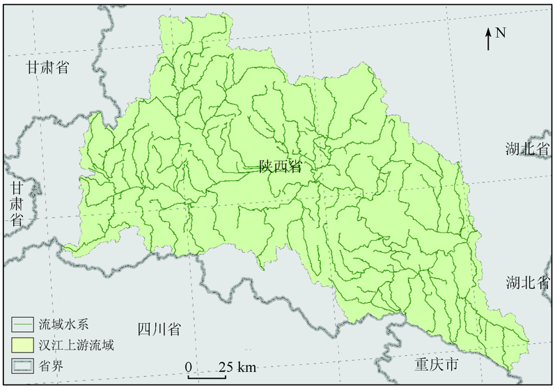
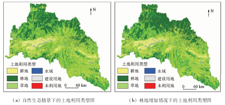
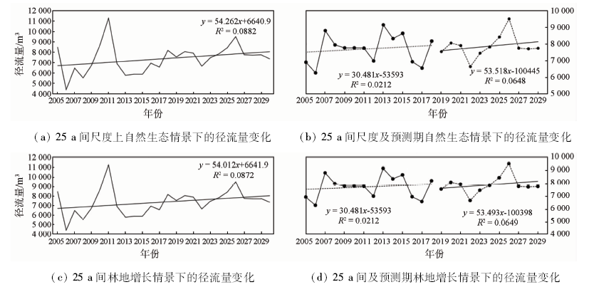
The main driving factors of runoff change are climate change and land use. In order to accurately predict the runoff change trend in the upper reaches of Hanjiang River in the future, the authors predicted runoff changes under the two land-use change modes based on SWAT model, weather generator BCC /RCG-WG and Ca-Markov model. The setting of land-use scenarios was based on the prediction results of Ca-Markov model. The results show that, in the future, the runoff in the upper reaches of Hanjiang River will show an obvious upward trend, and the increase rate of runoff under the scenario of increasing forest land is less than that in the natural ecological scenario, which may be related to the increase of ecological water demand caused by the increase of forest land. Therefore, the protection of water resources in the upper reaches of Hanjiang River is not feasible. Researchers should follow the natural growth law of vegetation, continue the current ecological protection policy, try to reduce man-made pollution and improve the ideological awareness of water conservation.
马新萍, 武涛, 余玉洋. 基于SWAT模型的汉江上游流域径流情景预测研究[J]. 国土资源遥感, 2021, 33(1): 174-182.
MA Xinping, WU Tao, YU Yuyang. A study of runoff scenario prediction in the upper reaches of Hanjiang River based on SWAT model. Remote Sensing for Land & Resources, 2021, 33(1): 174-182.
Song X M, Zhang J Y, Zhan C S, et al. Research Progress on the impact of climate change and human activities on hydrological cycle[J]. Journal of Water Conservancy, 2013,44(7):779-790.
Xia J, Ma X Y, Zou L, et al. Quantitative study on the impact of climate change and human activities on runoff change in the upper reaches of Hanjiang River[J]. South to North Water Diversion and Water Conservancy Science and Technology, 2017,15(1):1-6.
Shi C, Xia J, She D X, et al. Temporal and spatial evolution of ecological water demand of woodland vegetation in the upper reaches of Hanjiang River under climate change[J]. Resources and Environment in the Yangtze River Basin, 2016,25(4):580-589.
[4]
Worku T, Khare D, Tripathi S K. Modeling runoff-sediment response to land use/land cover changes using integrated GIS and SWAT model in the Beressa watershed[J]. Environmental Earth Sciences, 2017,76(16):550.
[5]
Ayivi F, Jha M K. Estimation of water balance and water yield in the Reedy Fork-Buffalo Creek Watershed in North Carolina using SWAT[J]. International Soil and Water Conservation Research, 2018:S2095633917302411.
[6]
Moshtaghi B, Niksokhan M H, Ghazban F, et al. Assessing the Impacts of Climate Change on the Quantity and Quality of Agricultural Runoff (Case Study:GOLGOL River Basin)[J]. Irrigation and Drainage, 2018: 468-478.
[7]
Shiferaw H, Gebremedhin A, Gebretsadkan T, et al. Modelling hydrological response under climate change scenarios using SWAT model:The case of Ilala watershed,Northern Ethiopia[J]. Modeling Earth Systems and Environment, 2018: 546-556.
[8]
Dhami B, Himanshu S K, Pandey A, et al. Evaluation of the SWAT model for water balance study of a mountainous snowfed river basin of Nepal[J]. Environmental Earth Sciences, 2018,77(1):21.
[9]
Yan X M, Lu W X, An Y K, et al. Uncertainty analysis of parameters in non‐point source pollution simulation:Case study of the application of the Soil and Water Assessment Tool model to Yitong River watershed in northeast China[J]. Water and Environment Journal, 2019,33(3):246-237.
[10]
Achamyeleh M, van Leon R, Woyessa Y L. Techniques for calibration and validation of SWAT model in data scarce arid and semi-arid catchments in South Africa[J]. Journal of Hydrology:Regional Studies, 2019,25:56-67.
[11]
Achamyeleh M. Hydrology;Findings in the Area of Hydrology Reported from University of Oslo (Uncertainty In Simulation of Land-use Change Impacts On Catchment Runoff With Multi-timescales Based On the Comparison of the Hspf and SWAT Models)[J]. Science Letter, 2019,55:66-67.
[12]
McDonald S, Mohammed I N, Bolten J D, et al. A web-based decision support system tools:The Soil and Water Assessment Tool online visualization and analyses (SWAT Online) and NASA earth observation data downloading and reformatting tool (NASAaccess)[J]. Environmental Modelling and Software, 2019,87:486-495.
[13]
Arnold J G, Srinivasan R, Ramanarayanan T S, et al. Water resources of the Texas gulf basin[J]. Water Science and Technology, 1999,39(3):121-133.
[14]
McDonald S, Mohammed I N, Bdten J D, et al. Web-based decision support system tools:The Soil and Water Assessment Tool online visualization and analyses (SWAT Online) and NASA earth observation data downloading and reformatting tool (NASA access)[J]. Environmental Modelling and Software, 2019,2(3):56-68.
Wang Y, Zhang Q, Wang J S, et al. Hydrological impact of land use and climate change on Tao River Basin Based on SWAT[J]. Deserts in China, 2017,37(1):175.
Yuan Y Z, Zhang Z D, Meng J H. Effects of land use and climate change on runoff in Liuxi River Basin based on SWAT model[J]. Chinese Journal of Applied Ecology, 2015,26(4):989.
pmid: 26259438
Liu S L, An N N, Yi Y J, et al. Spatiotemporal correlation between soil erosion and NDVI in the middle reaches of Lancang River Based on SWAT Model[J]. Journal of Soil and Water Conservation, 2016,30(1):62.
Meng X Y, Wang H, Lei X H, et al. Simulation, verification and analysis of hydrological related components in Jingbo River Basin based on SWAT model driven by cmdas[J]. Journal of Ecology, 2017,37(21):7114.
Guo J T, Zhang Z Q, Wang S P, et al. Effects of land use and climate change on Runoff in Chaohe River Basin using SWAT model[J]. Journal of Ecology, 2014,34(6):1559.
Qu Y J, Cheng X R, Yu M K, et al. Runoff simulation of land use change in Qujiang River Basin based on SWAT model[J]. Study on Soil and Water Conservation, 2019,26(1):130-134.
[22]
Anand J, Gosain A K, Khosa R. Prediction of land use changes based on land change modeler and attribution of changes in the water balance of Ganga Basin to land use change using the SWAT model[J]. Science of the Total Environment, 2018,644:503-519.
Wu L C, Song Y Y. Application of weighted Markov chain in precipitation prediction of Yulin City[J]. People’s Yangtze River, 2017,48(s1):82-84,100.
[24]
Gong W F, Li Y, Fan W Y, et al. Analysis and simulation of land use spatial pattern in Harbin prefecture based on trajectories and cellular automata-Markov modelling[J]. International Journal of Applied Earth Observation and Geoinformation, 2015(34):207-216.
Huang X L, Liu D Y. Study on land use prediction of Tianjin based on Ca Markov model[J]. China Agricultural Science and Technology Guide, 2012,14(5):84-89.
[26]
廖要明. 中国天气发生器BCC/RCG-WG的研究与应用[D]. 北京:北京师范大学, 2012.
Liao Y M. Research and application of BCC/rcg-wg weather generator in China[D]. Beijing:Beijing Normal University, 2012.
[27]
Schuol J, Abbaspour K C, Srinivasan R, et al. Estimation of freshwater availability in the West African sub-continent using the SWAT hydrologic model[J]. Journal of Hydrology, 2008,352(1/2):30-49.
Central Government Portal. Outline of national forest land protection and utilization planning (2010—2020)[EB/OL].(2010-8-24). http://www.gov.cn/zxft/ft205/content_1695019.htm.
[29]
叶加俊. 汉江上游流域径流模拟及未来气候变化响应[D]. 武汉:华中科技大学, 2018.
Ye Jiajun. Runoff simulation and future climate change response in the upper reaches of Hanjiang River[D]. Wuhan:Huazhong University of Science and Technology, 2018.
 2021, Vol. 33
  ), 武涛3, 余玉洋2