Please wait a minute...
 
国土资源遥感  2021, Vol. 33 Issue (1): 138-144    DOI: 10.6046/gtzyyg.2020095
     技术方法 本期目录 | 过刊浏览 | 高级检索 |
基于高光谱的土壤碳酸钙含量估算模型研究
吴倩(), 姜琦刚(), 史鹏飞, 张莉莉
吉林大学地球探测科学与技术学院,长春 130026
The estimation of soil calcium carbonate content based on Hyperspectral data
WU Qian(), JIANG Qigang(), SHI Pengfei, ZHANG Lili
College of Geo-exploration Science and Technology, Jilin University, Changchun 130026, China
全文: PDF(4841 KB)   HTML  
输出: BibTeX | EndNote (RIS)      
摘要 

土壤中碳酸钙的含量是土壤分类及肥力评价的重要依据。研究选取陕西省黄土高原区的78个黄绵土土壤样品为研究对象,在分析碳酸钙含量的基础上,采用SVC HR-1024i便携式光谱仪获取土壤样品的可见光、近红外与短波红外高光谱反射率(350~2 500 nm)数据,对原始光谱曲线分别进行一阶微分、二阶微分和连续统去除3种数学变换,运用相关分析法和连续投影算法分别进行敏感波段的选取,采用随机森林回归建立土壤碳酸钙的估算模型。结果表明: 黄绵土的光谱曲线特征相似,在1 440 nm,1 900 nm和2 200 nm等处均存在明显的吸收特征,且碳酸钙含量与光谱反射率呈现正相关态势; 基于二阶微分与连续投影算法的随机森林估算模型精度最高,验证集R2为0.82,相对分析误差(residual predictive deviation,RPD)值为2.37。

服务
把本文推荐给朋友
加入引用管理器
E-mail Alert
RSS
作者相关文章
吴倩
姜琦刚
史鹏飞
张莉莉
关键词 碳酸钙含量黄绵土高光谱连续投影算法随机森林回归    
Abstract

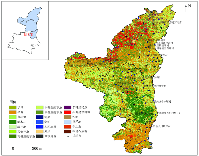
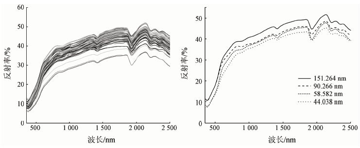
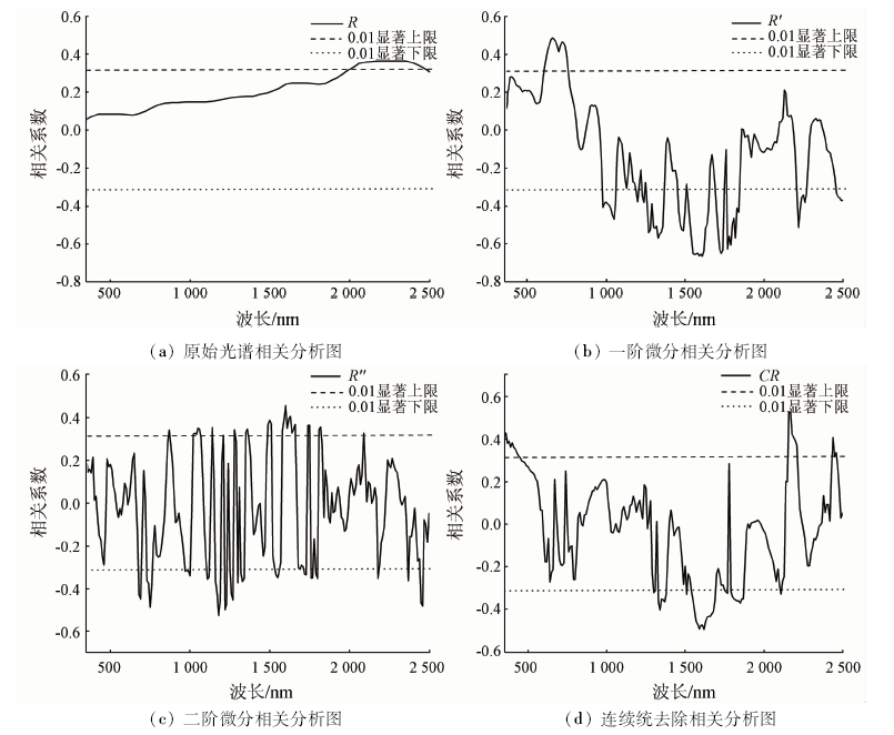
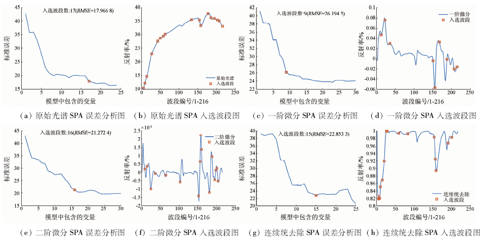
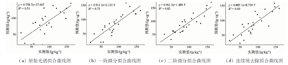
Carbonate content in soil is an important basis for soil classification and fertility evaluation. Based on an analysis of calcium carbonate content, the authors chose 78 soil samples from Loess Plateau of Shaanxi Province as the research objects. The visible near infrared hyperspectral reflectance (350~2 500 nm) data of soil samples were obtained by hyperspectral imager. Three mathematical transformations, i.e., first-order differentiation, second-order differentiation and continuum removal, were carried out on the original spectral curve, and correlation analysis was used. The method and the continuous projection algorithm were used to select the sensitive band respectively, and the Stochastic Forest regression was used to establish the estimation model of soil calcium carbonate. According to the results obtained, the spectral curve characteristics of Huangmian soil are almost the same, there are obvious absorption characteristics at 1 440 nm, 1 900 nm, 2 200 nm and so on, and the calcium carbonate content and spectral reflectance show a positive correlation trend; the accuracy of random forest estimation model based on the second-order differential and continuous projection algorithm is the highest, the validation set R 2 is 0.82, and the PRD value is 2.37.

Key wordscalcium carbonate    Huangmian soil    hyperspectral    continuous projection algorithm    random forest regression
收稿日期: 2020-04-07      出版日期: 2021-03-18
ZTFLH:  TP79  
基金资助:中国地质调查项目“全国地球关键带遥感地质调查”资助(DD20190536)
通讯作者: 姜琦刚
作者简介: 吴 倩(1997-),女,硕士研究生,主要从事遥感制图及其技术应用研究。Email: 1148545835@qq.com
引用本文:   
吴倩, 姜琦刚, 史鹏飞, 张莉莉. 基于高光谱的土壤碳酸钙含量估算模型研究[J]. 国土资源遥感, 2021, 33(1): 138-144.
WU Qian, JIANG Qigang, SHI Pengfei, ZHANG Lili. The estimation of soil calcium carbonate content based on Hyperspectral data. Remote Sensing for Land & Resources, 2021, 33(1): 138-144.
链接本文:  
https://www.gtzyyg.com/CN/10.6046/gtzyyg.2020095      或      https://www.gtzyyg.com/CN/Y2021/V33/I1/138
Fig.1  研究区地理位置及采样点分布
样本集 数目 最小值/(g·kg-1) 最大值/(g·kg-1) 平均值/(g·kg-1) 标准差 偏度 变异系数/%
建模样本 52 11.109 173.509 85.365 28.262 0.457 44.82
验证样本 22 11.236 175.077 87.607 8 33.798 0.253 49.99
总样本 74 11.109 175.077 86.362 30.536 0.354 46.94
Tab.1  土壤样本碳酸钙含量的统计结果
Fig.2  研究样本波长反射率图
Fig.3  基于相关分析(CA)的敏感波段筛选图
Fig.4  基于连续投影算法(SPA)的敏感波段筛选图
模型 波段选取方法 建模波段数 建模集 验证集
R2 RMSE R2 RMSEp RPD
RFR- R CA 54 0.59 20.43 0.41 25.22 1.43
SPA 17 0.60 20.03 0.51 22.56 1.49
RFR- R' CA 82 0.76 19.19 0.68 19.94 1.88
SPA 9 0.79 17.56 0.73 16.56 2.32
RFR- R″ CA 54 0.74 12.36 0.70 13.45 2.21
SPA 16 0.89 11.25 0.82 12.79 2.37
RFR- CR CA 44 0.71 14.28 0.58 18.62 1.83
SPA 15 0.68 17.11 0.69 19.64 1.88
Tab.2  土壤碳酸钙含量的敏感波段的RFR模型
Fig.5  基于SPA的四种数学变换RFR模型实测值与预测值验证集拟合图
[1] 赵其国, 史学正. 土壤资源概论[M]. 北京: 科学出版社科学, 2017: 15-20.
Zhao Q G, Shi X Z. Introduction to soil resources[M]. Beijing: Science Press, 2017: 15-20.
[2] 陈留美, 张甘霖. 滨海沉积物发育的水稻土时间序列母质均一性判定与特性演变[J]. 土壤学报, 2009,46(5):753-763.
Chen L M, Zhang G L. Determination of parent material homogeneity and evolution of characteristics of paddy soils developed in coastal sediments[J]. Soil Journal, 2009,46(5):753-763.
[3] 张宁, 何兴东, 邬畏. 腾格里沙漠3种土壤有机质和碳酸钙特征[J]. 生态学报, 2009,29(8):4095-4101.
Zhang N, He X D, Wu W. Characteristics of organic matter and calcium carbonate in three soils of Tengger Desert[J]. Acta Ecologica, 2009,29(8):4095-4101.
[4] 童庆禧, 张兵, 张立福. 中国高光谱遥感的前沿进展[J]. 遥感学报, 2016,20(5):689-707.
Tong Q X, Zhang B, Zhang L F. Current progress of hyperspectral remote sensing in China[J]. Journal of Remote Sensing, 2016,20(5):689-707.
[5] Gaffey S J. Spectral reflectance of carbonate minerals in visible and near infrared(0.35~2.55 μm):A nhydrous carbonate minerals[J]. Journal of Geophysical Research, 1987,92:1429— 1440.
[6] 张婷婷. 基于PLS模型的农业土壤成分高光谱遥感反演研究[D]. 长春:吉林大学, 2010.
Zhang T T. Partial least squares modeling of hyperspectral remote sensing for mapping agricultural soil properties[D]. Changchun:Jilin University, 2010.
[7] Stenberg B, Viscarra Rossel R A, Mouazen A M, et al. Visible and near infrared spectroscopy in soil science[J]. Advances in A gronomy, 2010,107:163— 215.
[8] Sexton J, Laake P. Standard errors for bagged and random forest estimators[J]. Computational Statistics & Data Analysis, 2009,53(3):801-811.
[9] 宋建国, 高强山, 李哲. 随机森林回归在地震储层预测中的应用[J]. 石油地球物理勘探, 2016,51(6):1203-1211.
Song J G, Gao Q S, Li Z. Application of stochastic forest regression in seismic reservoir prediction[J]. Petroleum Geophysical Exploration, 2016,51(6):1203-1211.
[10] 秦倩如. 基于高光谱的陕西省土壤游离铁与碳酸钙含量预测研究[D]. 杨凌:西北农林科技大学, 2019.
Qin Q R. Prediction of soil free iron and calcium carbonate content based on hyperspectral data in Shaanxi Province[D]. Yang Ling:Northwest Agricultural and Forestry University of Science and Technology, 2019.
[11] 单海滨, 蒋平安, 颜安, 等. 基于高光谱的北疆绿洲农田灰漠土有机质反演[J]. 农业资源与环境学报, 2018,35(3):276-282.
Shan H B, Jiang P A, Yan A, et al. Hyperspectral retrieval of organic matter in grey desert soil of oasis farmland in Northern Xinjiang[J]. Journal of Agricultural Resources and Environment, 2018,35(3):276-282.
[12] Araújo M C U, Saldanha T C B, Galvão R K H, et al. The successive projections algorithm for variable selection in spectroscopic multicomponent analysis[J]. Chemometrics and Intelligent Laboratory Systems, 2001,57(2):65-73.
[13] 杨红云, 周琼, 杨珺, 等. 基于高光谱的水稻叶片氮素营养诊断研究[J]. 浙江农业学报, 2019,31(10):1575-1582.
Yang H Y, Zhou Q, Yang J, et al. Hyperspectral diagnosis of nitrogen nutrition in rice leaves[J]. Zhejiang Journal of Agriculture, 2019,31(10):1575-1582.
[14] 李勋兰, 易时来, 何绍兰, 等. 高光谱成像技术的柚类品种鉴别研究[J]. 光谱学与光谱分析, 2015,35(9):2639-2643.
pmid: 26669182
Li X L, Yi S L, He S L, et al. Identification of pummelo cultivars based on hyperspectral imaging technology[J]. Spectroscopy and Spectral Analysis, 2015,35(9):2639-2643.
pmid: 26669182
[15] 秦倩如, 齐雁冰, 吴娟, 等. 基于高光谱的土壤游离铁随机森林模型估算研究[J]. 土壤通报, 2018,49(6):1286-1293.
Qin Q R, Qi Y B, Wu J, et al. Estimation of soil free iron random forest model based on hyperspectral data[J]. Soil Bulletin, 2018,49(6):1286-1293.
[16] 彭杰, 周清, 张杨珠, 等. 有机质对土壤光谱特性的影响研究[J]. 土壤学报, 2013,50(3):517-524.
Peng J, Zhou Q, Zhang Y Z, et al. Effect of soil organic m atter on spectral characteristics of soil[J]. Acta Pedologica Sinica, 2013,50(3):517-524.
[17] 洪长桥, 郑光, 陈昌春. 苏北滨海土壤碳酸钙含量反射光谱估算研究[J]. 土壤学报, 2016,53(5):1121-1129.
Hong C Q, Zheng G, Chen C C. Study on reflectance spectrum estimation of calcium carbonate content in coastal soil of Northern Jiangsu[J]. Journal of Soil Science, 2016,53(5):1121-1129.
[18] 张东, 张飞, 等. 分数阶微分在盐渍土高光谱数据预处理中的应用[J]. 农业工程学报, 2014,30(24):151-160.
Zhang D, Zhang F, et al. Application of fractional differential in preprocessing hyperspec-tral data of saline soil[J]. Transactions of the Chinese Society of Agricultural Engineering, 2014,30(24):151-160.
[19] Gomez C, Philippe L, Guillaume C. Continuum removal versus PLSR method for clay and calcium carbonate content estimation from laboratory and airborne hyperspectral measurements[J]. Geoderma, 2008,148(2):141-148.
[1] 王嘉芃, 徐建国, 沈家晓, 张登荣. 德兴铜矿矿山重金属污染修复效果高光谱遥感评价[J]. 自然资源遥感, 2023, 35(3): 284-291.
[2] 郑宗生, 刘海霞, 王振华, 卢鹏, 沈绪坤, 唐鹏飞. 改进3D-CNN的高光谱图像地物分类方法[J]. 自然资源遥感, 2023, 35(2): 105-111.
[3] 张国建, 刘胜震, 孙英君, 俞凯杰, 刘丽娜. 基于弱监督鲁棒性自编码的高光谱异常检测[J]. 自然资源遥感, 2023, 35(2): 167-175.
[4] 孔卓, 杨海涛, 郑逢杰, 李扬, 齐济, 朱沁雨, 杨忠霖. 高光谱遥感图像大气校正研究进展[J]. 自然资源遥感, 2022, 34(4): 1-10.
[5] 张鹏强, 高奎亮, 刘冰, 谭熊. 联合空谱信息的高光谱影像深度Transformer网络分类[J]. 自然资源遥感, 2022, 34(3): 27-32.
[6] 孙肖, 徐林林, 王晓阳, 田野, 王伟, 张中跃. 基于优化K-P-Means解混方法的高光谱图像矿物识别[J]. 自然资源遥感, 2022, 34(3): 43-49.
[7] 晏红波, 韦晚秋, 卢献健, 杨志高, 黎振宝. 基于高光谱特征的土壤含水量遥感反演方法综述[J]. 自然资源遥感, 2022, 34(2): 1-9.
[8] 孙肖, 彭军还, 赵锋, 王晓阳, 吕洁, 张登峰. 基于空间统计学的高光谱遥感影像主成分选择方法[J]. 自然资源遥感, 2022, 34(2): 37-46.
[9] 王茜, 任广利. 高光谱遥感异常信息在阿尔金索拉克地区铜金矿找矿工作中的应用[J]. 自然资源遥感, 2022, 34(1): 277-285.
[10] 曲海成, 王雅萱, 申磊. 多感受野特征与空谱注意力结合的高光谱图像超分辨率算法[J]. 自然资源遥感, 2022, 34(1): 43-52.
[11] 陈洁, 张立福, 张琳珊, 张红明, 童庆禧. 紫外-可见光水质参数在线监测技术研究进展[J]. 自然资源遥感, 2021, 33(4): 1-9.
[12] 高文龙, 张圣微, 林汐, 雒萌, 任照怡. 煤矿开采中SOM的遥感估算和时空动态分析[J]. 自然资源遥感, 2021, 33(4): 235-242.
[13] 刘咏梅, 范鸿建, 盖星华, 刘建红, 王雷. 基于无人机高光谱影像的NDVI估算植被盖度精度分析[J]. 自然资源遥感, 2021, 33(3): 11-17.
[14] 李双权, 马玉凤, 刘勋, 李长春, 杜军. 郑州邙山枣树沟黄土剖面常量元素含量的高光谱反演[J]. 自然资源遥感, 2021, 33(3): 121-129.
[15] 杜程, 李得林, 李根军, 杨雪松. 基于高原盐湖光谱特性下的溶解氧反演应用与探讨[J]. 自然资源遥感, 2021, 33(3): 246-252.
Viewed
Full text


Abstract

Cited

  Shared   
  Discussed   
京ICP备05055290号-2
版权所有 © 2015 《自然资源遥感》编辑部
地址:北京学院路31号中国国土资源航空物探遥感中心 邮编:100083
电话:010-62060291/62060292 E-mail:zrzyyg@163.com
本系统由北京玛格泰克科技发展有限公司设计开发