Development of farmland drought remote sensing dynamic monitoring system based on Android
LONG Zehao1(), ZHANG Tianyuan1, XU Wei1, QIN Qiming1,2()
1. Institute of Remote Sensing and Geographical Information System, School of Earth and Space Science, Peking University, Beijing 100871, China 2. Geographic Information System Technology Innovation Center of the Ministry of Natural Resources, Beijing 100871, China
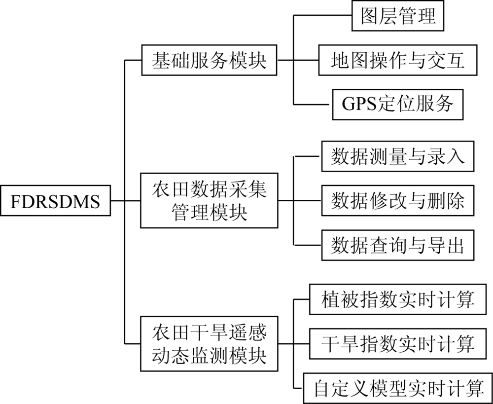
A farmland drought remote sensing dynamic monitoring system has been established on the Android mobile platform in order to meet the actual needs of users for observation of agricultural conditions such as farmland drought. For the problem of inefficiency in traditional manual field recording by users, the system combines the advantages of portable mobile devices and global positioning system (GPS) to realize the digital management of farmland data, and completes a set of processing flow from field data entry, processing to export. With the purpose of real-time drought dynamic monitoring, the system uses the massive remote sensing data management and powerful calculating ability advantages provided by the Google Earth Engine remote sensing cloud computing platform, utilizes multi-source remote sensing data such as Landsat, MODIS and Sentinel, applies the Flask framework to implement the Google Earth Engine platform Python service interface access scheme, and completes the function of dynamic drought monitoring for farmland, which provides users with a technical application platform for selecting the remote sensing data source, calculating the drought monitoring model and finally generating the grade thematic map of drought.
龙泽昊, 张添源, 许伟, 秦其明. 基于Android的农田干旱遥感动态监测系统研制[J]. 国土资源遥感, 2021, 33(2): 256-261.
LONG Zehao, ZHANG Tianyuan, XU Wei, QIN Qiming. Development of farmland drought remote sensing dynamic monitoring system based on Android. Remote Sensing for Land & Resources, 2021, 33(2): 256-261.
Yao Y, Chen X, Qian J. Advance in agricultural drought monitoring using remote sensing data[J]. Spectroscopy and Spectral Analysis, 2019, 39(4):1005-1012.
[2]
Liu X, Zhu X, Pan Y, et al. Agricultural drought monitoring:Progress,challenges,and prospects[J]. Journal of Geographical Sciences, 2016, 26(6):750-767.
doi: 10.1007/s11442-016-1297-9
Jin C, Qin Q M, Wang D D, et al. Design and implementation of drought monitoring remote sensing supporting system[J]. Journal of Remote Sensing, 2007(3):420-425.
[4]
Wu B, Meng J, Li Q, et al. Remote sensing-based global crop monitoring:Experiences with China’s CropWatch system[J]. International Journal of Digital Earth, 2014, 7(2):113-137.
doi: 10.1080/17538947.2013.821185
Li D R. Towards geospatial information technology in 5G/6G era[J]. Acta Geodaetica et Cartographica Sinica, 2019, 48(12):1475-1481.
[6]
Novac O C, Novac M, Gordan C, et al. Comparative study of google android,apple IOS and microsoft windows phone mobile operating systems[C]// 2017 14th International Conference on Engineering of Modern Electric Systems (EMES).IEEE, 2017:154-159.
Zhao Z M, Gao L R, Chen D, et al. Development of satellite remote sensing and image processing platform[J]. Journal of Image and Graphics, 2019, 24(12):2098-2110.
[10]
Dong J, Xiao X, Menarguez M A, et al. Mapping paddy rice planting area in northeastern asia with Landsat 8 images,phenology-based algorithm and Google Earth Engine[J]. Remote Sensing of Environment, 2016, 185:142-154.
doi: 10.1016/j.rse.2016.02.016
[11]
Gorelick N, Hancher M, Dixon M, et al. Google Earth Engine:Planetary-scale geospatial analysis for everyone[J]. Remote Sensing of Environment, 2017, 202:18-27.
doi: 10.1016/j.rse.2017.06.031
[12]
Ghulam A, Qin Q, Zhan Z. Designing of the perpendicular drought index[J]. Environmental Geology, 2007, 52(6):1045-1052.
doi: 10.1007/s00254-006-0544-2
[13]
Ghulam A, Qin Q, Teyip T, et al. Modified perpendicular drought index (MPDI):A real-time drought monitoring method[J]. ISPRS Journal of Photogrammetry and Remote Sensing, 2007, 62(2):150-164.
doi: 10.1016/j.isprsjprs.2007.03.002
Qin Q M, You L, Zhao Y, et al. Soil line automatic identification algorithm based on two-dimensional feature space[J]. Transactions of the Chinese Society of Agricultural Engineering, 2012, 28(3):167-171.
[15]
Baret F, Clevers J, Steven M D. The robustness of canopy gap fraction estimates from red and near-infrared reflectances:A comparison of approaches[J]. Remote Sensing of Environment, 1995, 54(2):141-151.
doi: 10.1016/0034-4257(95)00136-O
 2021, Vol. 33
  ), 张添源1, 许伟1, 秦其明1,2(